

wxeyeNH
-
Posts
9,327 -
Joined
-
Last visited
Content Type
Profiles
Blogs
Forums
American Weather
Media Demo
Store
Gallery
Posts posted by wxeyeNH
-
-
26.2 IP 12"
-
 1
1
-
-
Flipping back to SN. 25.8F My accumulation had been stuck at around 12" but will now commence again.
-
1
-
-
-
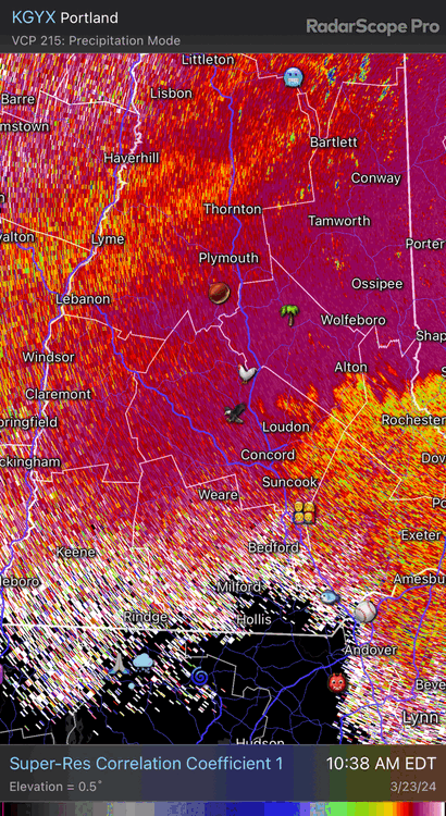
and just like that it went from SN+ to IP. KLW, the CC is radar Correlation Coefficent. It's a good way to see where the snow sleet line is.
-
 2
2
-
-
6 minutes ago, dendrite said:
Back to all pellets. Roared right back in on CC.
Really interesting to watch the CC. The mix wants to come up my way but at the last moment gets shunted to the east.
SN but close to SN+ 25.6F
-
1
-
-
1 minute ago, dendrite said:
Looking at that collapse SE and the good push SE on ENX I’m thinking that may be about it for the sleet extent. Probably 50/50 sn/ip now.
I flipped almost to all IP about half an hour ago but back to 100% snow. Very good snow growth too
-
2
-
-
25.2F SN Over the past 45 minutes IP has mixed in. At one point 30 minutes ago it almost changed to all IP. Back to all snow
-
1
-
-
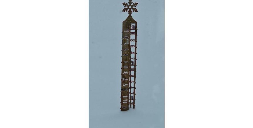
2pm SN- IP- goes back and forth 25.2F Just under 12" but I assume sleet will mash down the pack. I could use a snowboard and reclear in 6 hours but I'm just going to watch the snow stake.
-
2
-
-
24.9F SN but the first IP is trying to mix in. 11.5"
-
2
-
-
24.8F Snow had been moderate most of the day but now SN+
-
1
-
-
SN 24.6F Snow growth has improved. Not the fine sand from earlier.
-
2
-
-
17 minutes ago, dendrite said:
Hanging onto a wedge of cold here despite the mixing making its way up to Wolfeboro east of me. Looks like it’s nearing e18 on 93 now.
I'm watching your obs carefully as your only 20 miles SSE as the crow flies. I just looked at the HRRR and 12Z GFS and it seems it is nudging colder. Also noted on the HRRR some heavy qpf comes in this evening. The IP line looks to get to me or about 5 miles north. It is going to fun watching how this sets up. I went with 7-14" and still over 1" qpf to come. If this stays snow accums are going to be huge.
Noon SN 24.3F
-
SN 24F Just passing through 10". Snowing 1-2" per hour. Snow growth has improved. Warmer air moving in aloft?
-
1
-
-
23.8F SN 8.5"ish
-
2
-
-
845am Moderate to heavy snow. Fair snow growth. Vis est 1/2 mile 23.4F 7.25"
-
2
-
-
29.4/-1 2" of qpf. The only questions is how much is pingers tomorrow?
-
2
-
-
1 minute ago, CoastalWx said:
I thought Brian had a good take. At least a guess as good as any. I don't see downsloping as real issue. Winds at 925 and below are ENE to NE but light. Big time lift is 850 and above where winds are srly. It's more about the temps aloft. Pretty sure you'll be below 32. Possibly Brian as well.
Thanks guys. In strong Nor'easter downslope off the Whites make Plymouth and my area a bit of a snowhole. I do best in SWFE. So I totally agree no downslope issues. Probably ping for awhile. Snowstake is out and ready!
-
27.6F high clouds just moving in. So we are about at our high temp for the day
-
Just now, CoastalWx said:
That srn VT to Brian-Gene area is a wild card.
Scott, as you know I'm no Met and many of you on here know much more than me. I am pretty active in our 10,000 member Newfound Lake FB group. Last year every once in a while I would make a weather post or a forecast. People started latching on and now I'm very well known locally. WMUR Mets are good but they tailor their forecasts to S NH in the big population centers. Being 50 miles north and higher in elevation our local weather is different. Coming from Metro Boston where the coastal front setup or sea breeze was the biggest challenge up here it is elevation changes. PF and Alex get upslope. We don't. Sometimes we get shadowed from the Whites just to our north and northeast. So I have been trying to figure things out on my own without mucking up the SNE forums.
.
-
1 hour ago, dendrite said:
Nammy has a decent flip back to snow up here at the end. That would probably create some power issues.
Brian, give me a guess for my area? Clown maps are crazy but showing 20" of snow but I think they are including sleet. 8-12" or would you go higher? I have not been on the forum much..
-
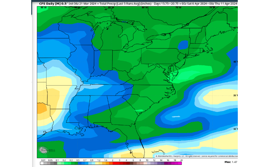
I subscribe to Weatherbell and looked at the extended CFSv2. I saw on another site that this is a good model to look at the extended forecast. It shows average precip forecasted over a 5 day period. Here is what it shows as far a precip for Apil 6th through 11th. It would be ironic if a Gulf Storm were to be forming knocking out Texas area viewing while we are still clear. Models can barely get 5 days out correct so I'm sure this will change each day as we approach April.
-
1 minute ago, alex said:
Done. A little less intense now but still ripping.
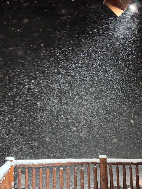
A crazy good squall wasn't it!
-
 1
1
-
-
28.3 Light snow and blowing snow. Eyeballing 1 to 1 1/2". Jeez, that Euro for this weekend. 12-18" jack from Brian north.
-
1
-
-
Down to 29.4F Moderate snow 1" No residual salt on roads going to be a SShow.

The Congrats Dendrite Deck Destroyer 3/23-3/25 obs discussion
in New England
Posted
26.3F Parachutes. Over the past few hours the precipatation has changed from snow to IP and back several times. Most of the time it has been sleet. In the last 5 minutes it has again flipped to snow. Will this be it for the duration? i would think so.