

Crazy4Wx
-
Posts
203 -
Joined
-
Last visited
Content Type
Profiles
Blogs
Forums
American Weather
Media Demo
Store
Gallery
Posts posted by Crazy4Wx
-
-
On radar it looks like it's making a beeline towards Cape Coral & Ft. Myers
It is on track to go north of Ft. Myers. Port Charlotte gets the 12-16 ft surge. Tampa Bay gets the western eyewall with 150mph winds. Everything in between gets the eye.
.-
 1
1
-
 1
1
-
 2
2
-
-
We starting to get close to the time where minor jogs will depend who gets the SE eyewall. Looking at Sanibel and Cape Coral in particular. Regardless though, Ian has a large core and it going to effect a large area of populated real estate.
On current trajectory it would be more like Venice to Bradenton. Tampa Bay gets Western eye (which is bad with 155 mph winds) and Port Charlotte gets surge.
. -
137 kts SFMR in the west quad ("weak" side)..... major yikes.
Cat 5, and still strengthening
.-
1
-
-

High end Cat 4. Closing in on Cat 5
.-
1
-
-
At this angle of approach, Ft. Myers’s to Port Charlotte would get hammered with surge and Tampa Bay might get the western eye wall.
Doesn’t look good for Tampa Bay.-
1
-
-
Unreal intensification going on right now
Going to make a run at Cat 5. Might run out of time.
.-
2
-
-
1 minute ago, MDphotog said:
Wow, this cell could not hit at a worse time for the DC/Balt area. Very few will be paying attention or even be awake.
Won’t they send alerts to everyone’s phones as it gets closer?
-
So much for sleeping for the next hour. That cell looks like it could track close to my area.
-
2 minutes ago, yoda said:
SW of there by Orange... Culpepper would be next if warning were issued. But looks to slide just east of there
Looks to be tracking through some pretty dense population in the next hour. Not good.
-
5 minutes ago, yoda said:
Hail threat increasing on Radarscope with that cell
The one moving past Culpeper?
-
1 minute ago, Wmsptwx said:
Am I too hopeful, or does it appear that the rain may lighten awhile in New Orleans proper within couple hours?
Depends how far west it travels.
-
Just now, tim123 said:

They are getting pummeled with some of those bands right now.
-
2 minutes ago, hazwoper said:
Maybe. I just look at the radar and the reduction in stronger returns coming in from south of NO.
Tell that to Grand Isle…still getting hit with heavy rain…9 hours after landfall.
-
2 minutes ago, Hotair said:
All of NO without power due to “catastrophic transmission damage”
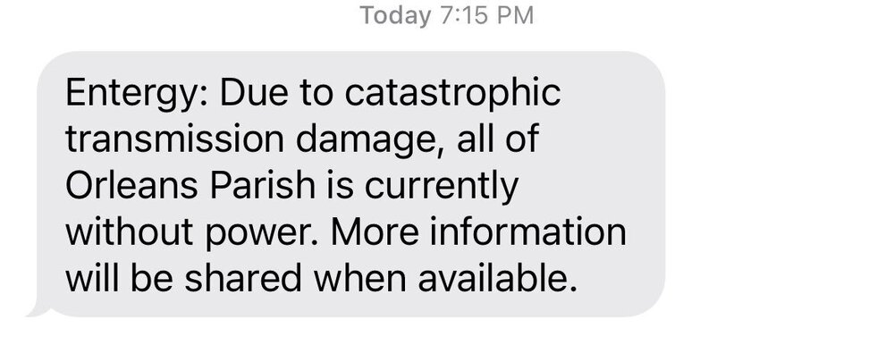
Do the pumps work without power?
-
 1
1
-
-
Sure looks like Mid City NOLA is gonna catch some of that band spinning off the eyewall.
Airport just getting that NE quad now
-
One more wobble East and NOLA city center gets that eyewall. Going to be close for them. Airport looks like it will certainly get hit by eyewall.
-
Sure looks like Ida has turned due North, if not NNE.
-
Heavy outer bands about to move into New Orleans.
-
1 minute ago, turtlehurricane said:
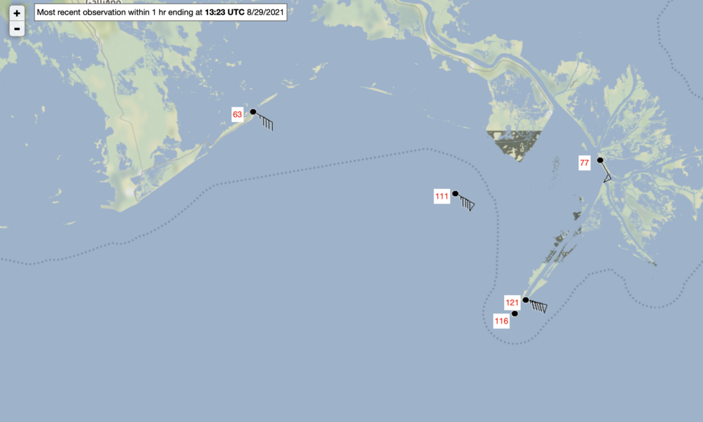
Wind gusts of 120+ mph (100+ sustained) on Mississippi Delta, these are observations that are technically on land. This is not even the eyewall!!! Just inner bands. This is extremely rare to see winds this high outside the eyewall.
This bands will definitely be going over New Orleans.
-
2
-
1
-
-
2 minutes ago, user13 said:
Pretty good wobble to the wnw in the last 30 min. Every inch counts for NoLa at this point.
On current heading the airport gets that eastern eyewall. Will be so close for downtown
-
Recon just turned toward Ida…I am thinking they find a monster.
-
Looks like recon should be getting to outer skirts of Ida in 10-15 mins
-
2 minutes ago, WEATHER53 said:
Best hope now for NO is it pushes further east and get out of ne quad
You know it’s bad when you hope to be in the eye.
-
2
-
-
Just now, tim123 said:
00z Rgem has eastern eyewall into New orleans.
I think we knew that was coming…going to be rough ride for the big easy


Hurricane Ian
in Tropical Headquarters
Posted
Don’t forget the 150mph winds in Tampa Bay area
.