psuhoffman
-
Posts
24,041 -
Joined
-
Last visited
Content Type
Profiles
Blogs
Forums
American Weather
Media Demo
Store
Gallery
Everything posted by psuhoffman
-
It’s ok. The 50/50 is fine. The blocking is fine. But the trough cuts off over Colorado then lifts up near Chicago. That’s the issue. There is cold in front available if it took a good track.
-
-
It won’t show up as a -NAO because of the lower heights near Iceland. It’s not a typical NAO. But that look is good. A block across Canada with a 50/50 is a good look even if it doesn’t show as an NAO block.
-
JB just had the greatest JB moment of all. Someone told me but I didn’t believe it. But yup he did it. He posted a video yelling at people for misrepresenting his forecast, while he misrepresented his forecast. He didn’t put up his actual forecast from November, he posted an edited map that he just published TODAY and talked about it as if it was his winter forecast. Then he drew on the map where he had above normal snow, implying he didn’t say there would be above normal in the 95 cities...when his actual winter forecast predicted 125% normal snow DC to Boston. He was literally lying about his forecast while yelling at people for lying about his forecast. He jumped the shark!
-
I was mostly analyzing how the gefs was trending towards the gfs op wrt what happens in the Atlantic. As for the op run I was analyzing what happens around day 5 that sets off the chain reaction after. I would never waste time analyzing specifics longer out than that on an op run unless it was just to have fun. But the op run is a look at one permutation of the atmospheres possible outcomes. Looking at how it got to that outcome to understand what we need to happen can be useful. Using an op run as a carbon copy forecast at day 10 or analyzing synoptic details at day 10 are a waste of time.
-
GEFS is trending the right way. Look at the changes the last 3 runs wrt the 50/50 and where the ridging is centered leading into the threat.
-
Thank you! Thanks! I love to teach! I am just as passionate about politics and history as I am weather. I just wish my students were as easy to “hook” as this audience lol. There are good and bad days...but the good make it worth it. One reason I like putting in the effort to make a post like that is I get to do what I love with another topic I love. Maybe someday I’ll go back and finish my meteorology degree and get paid to do this also
-
@Bob Chill @C.A.P.E. the way the gfs goes off on that beautiful tangent actually happens at only hour 120 or so. After the weekend storm instead of getting absorbed into the TPV that NS vort in Quebec dives in and phases with the fish storm early next week pulling it up into a 50/50. The wave break from that pumps the NAO ridge and sets to the crazy blocking across Canada that leads to everything after. That one thing sets off a chain reaction.
-
Yea I would much rather be analyzing a 24 hour plot of moisture convergence, fgen, vorticity etc to figure out where the death band is going to set up. But truth is in 90% of the time I’m stuck chasing long range unicorns or day 15 pattern changes. Even our rare amazing winters often have lots of dead space. 3 weeks after the second Jan 1996 storm. A month between storms in 2010. Even 2013/14 had a dead spot the second half of Dec and it was the most consistent non stop winter of my lifetime.
-
@frd there are so many variables it’s impossible to know them all. I know overall phase 7/8 in January are cold. But what does phase 8 correlate too when a purple polka dot unicorn does the Macarena while facing southeast on top of Mount Washington? Apparently there is some obscure reason why phase 7/8/1 actually suck whenever the mjo actually goes into 7/8/1! This would be 3 times in a row someone offered a reason why “in this very specific scenario” it’s not actually good. In 2018 things were delayed a week more than typical but an epic pattern did come in March. Yea it was March but it snowed in our area 3 times and one was significant! They wasn’t a fluke. Last year we never got a typical phase 8 response but the wave was very weak. And when I looked into what Furtado said there was a sample size of like 3 and 1 was cold, 2 not. So how that’s statistically significant? My guess is there are factors that can countermand the mjo or mute it. Especially when it’s a weak wave. But at some point it’s paralysis by analysis. You break down these pattern influencers into smaller and smaller categories and you don’t have enough examples to really know anything anymore. Besides what then happens in other phases? I asked Furtado what phases we want for cold in his specific scenario and he never answered. Was the answer we can’t get cold during low solar with a weak strat PV? They can’t be true! Do we want no mjo wave? Honestly I don’t know. He didn’t answer. Anyhow we can’t even predict the mjo very well at long range so it’s tool in long range predictions is limited. Remember last year it looked great then suddenly collapsed through the COD and cycled right back to the warm phases. Really screwed the unanimous calls for cold. Then after the fact a lot of people gave reasons but funny I don’t remember them saying anything before it became apparent.
-
The MJO in 7/8/1 is great, except when it ever actually goes into 7/8/1 and then it sucks.
-
Fringed
-
As of now the eps favors the warmer solution. But it’s not a case where there may or may not be a storm. The storm is there just the eps favors too much ridging in front and torches the temps. But watch that change in a dime if a future run decides to phase the ocean storm next week with the NS and suddenly there is a 50/50. Or it suddenly decides the NS vort in Canada next week is going to bomb. So imo it’s one of these situations that looks bad and isn’t likely but could flip on a dime if just one thing breaks our way. Ironically the gfs and euro flipped positions in the last 48 hours. Wrt the eps there was a huge spike in snow just southwest day 15. Looking at the members there were several “incoming” storms at day 15. Day 16 was going to be big. Lol
-
That’s some of the most redonculous blocking I’ve ever seen. All of Canada. Why it still manages to snow with a primary way west. I’d settle for just getting the 50/50 and have the storm stay under us. I like simple.
-
OK...this really is my last post... So the main mid level WAA is still aimed well to our northwest but look at the secondary mid level vorticity maximum and kink in the flow aimed at/attacking the CAD in the Mid Atlantic. This is the kind of thing the globals are not going to pick up at 4/5 days out and is a realistic option to hope for a better result. That is what is fueling the little thump on the NAM. Not saying it is right...we been through this dance with the NAM before...that that is a realistic way to eek out a back door win in this situation.
-
With a track this far north yes...The mountains in Vermont are also aligned good to get some upslope snows on Sunday after the low goes by and winds shift to the west. Might tack on another few inches in the higher elevations. Killington area might be all booked up. Forgot its a holiday weekend. This weekend gets crazy busy up there. Burlington VT is a really awesome town...and only 30 min drive to Stowe which will get absolutely blasted with snow the next few days from both systems and the upslope on Sunday. Trust me...they average about 300" of snow for a reason! Lake Placid NY is another good option...really nice town, Olympic venues to check out. North Conway NH is another good option more likely to have last minute lodging (because they have so damn much of it) but its further away.
-
Lake Placid isnt a bad option either
-
Last post for a while...have to get back to work This is the issue with the progression...EPS day 10 The timing of the ensembles is a little slower than the op but this shows the issue. The flow ahead of the trough is all out of the south. That is torching the mid levels. If we had some cold to work with in the mid's we could probably overcome the warmer surface temps...mix some cold down with a good track...but if we torch the mids and the surface...well its game over. So taking the 6z GFS that had snow as an example This wasnt perfect...it was still messy, the ridge would be better centered west not east of the Hudson Bay, but that 50/50 makes it work. Look at the flow now over us and to our northeast. Cutting off the southerly flow from torching us ahead of the trough. Plus it creates confluence to hold a high pressure in longer. This lead to the snowy solution on this run. The op euro though... That same feature is displaced where it can't help us and so the southerly flow torches us ahead of the system and there is no confluence to our north. It's close...but this isn't horseshoes or hand grenades. So how can we get to the look we need.... So there the energy that will be the day 10 threat is coming onshore in the west. We need to get one of those vorts numbered to amplify significantly and into the 50/50 spot. What happens on the euro op, 1 amplifies but remains cut off from the NS flow so its too far south, 3 gets absorbed into the TPV lobe and up into Greenland...2 washes out completely and 4 does end up where we need it but doesn't amplify enough and is way too weak to do much good. Get 3 and 1 to phase and pull them up into the 50/50 domain and that works. Get 2 and 4 to phase and amplify...get 4 to amplify by itself. None of those solutions would do us any good for snow BEFORE the day 10 threat... the flow is way to suppressive, could help give northern New England a light event...but any of those combo's would knock down the ridge to our northeast, create confluence and shunt the southerly flow ahead of the wave from destroying our thermal profile. Hope that explains what you were asking. Back to real life...
-
BTW wrt to the EPS, while the snow mean is unimpressive, there is a big spike just to our southwest day 14-15. A lot of members end day 15 about to blast us with a stj system, this time with cold locked in thanks to the lower heights to our northeast due to the storm day 10-12.
-
Euro depiction of slightly above normal temps between day 7-12 is reasonable given its stale cold air trapped under a ridge. But we can snow in that profile...especially if we can fix the ridge issue to our northeast allowing the mid levels to torch ahead of the wave. It's cooling again day 15 either way. GFS is too cold in the long range...we know that.
-
This look here day 13 actually fits the profile of our “positive AO big snowstorms”. Obviously we want a -AO. But when we scored snow with a +AO it was often in a look like this... Whatever happens with the day 10 threat the eps thinks that system migrated through the 50/50 region knocking down the ridge to our northeast. The fate of the day 10 seems to rest on the ability of some discreet wave before that to amplify just enough to knock down heights there ahead of the day 10 storm. A murkier proposition in the spread.
-
Eps isn’t there yet but trending the right way. Remember the Hudson Bay ridge look I posted wrt the 50/50. This is the h5 run to run change leading into the day 10 threat. This is exactly the trend we need. Lower the heights to our northeast and this becomes a classic snow look. After that the eps opens the door that the day 10 storm becomes a 50/50 for a threat later. Lots of possibilities with the current pattern progs. GEPS looked good day 10-15 also.
-
@RevWarReenactor North Conway NH is another good option. Lots to do there. Near Mt Washington. More lodging options. This weekend is likely to be very booked up. But it’s Further away. Burlington VT won’t get as much snow as the mountains but it’s a really awesome town. Dito Manchester VT.
-
@RevWarReenactor 12z euro update this is from the storm the next 48 hours this is from the weekend. VT still looks like the place to be given all that. Way more lodging than the areas in NY they get blasted. You can see how Albany is stuck in the screw zone SW of there. The PA stuff is mix to ice to rain...and not as much a sure thing. It’s going to be a great ski weekend up in VT that’s for sure! Speaking of...last night my shoulder was killing me from an injury I got skiing at Tremblant 20 years ago in College. I’m getting old...

-
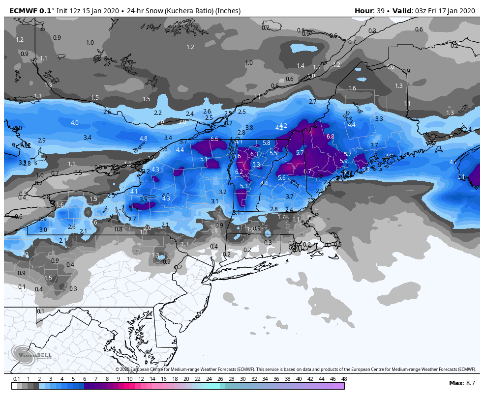
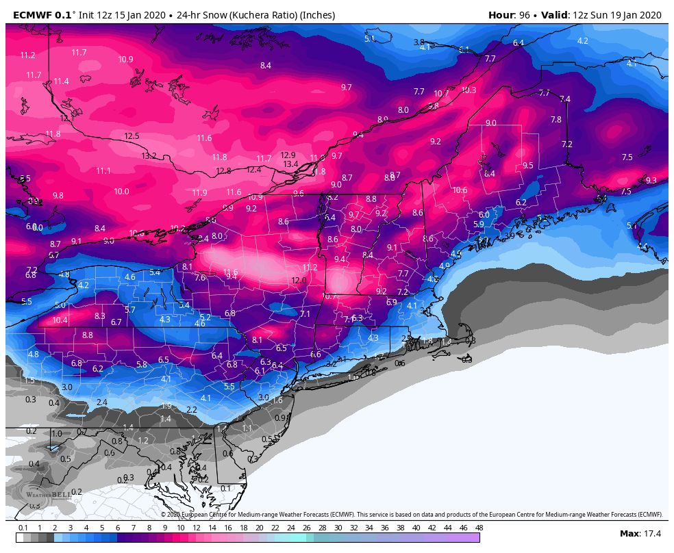
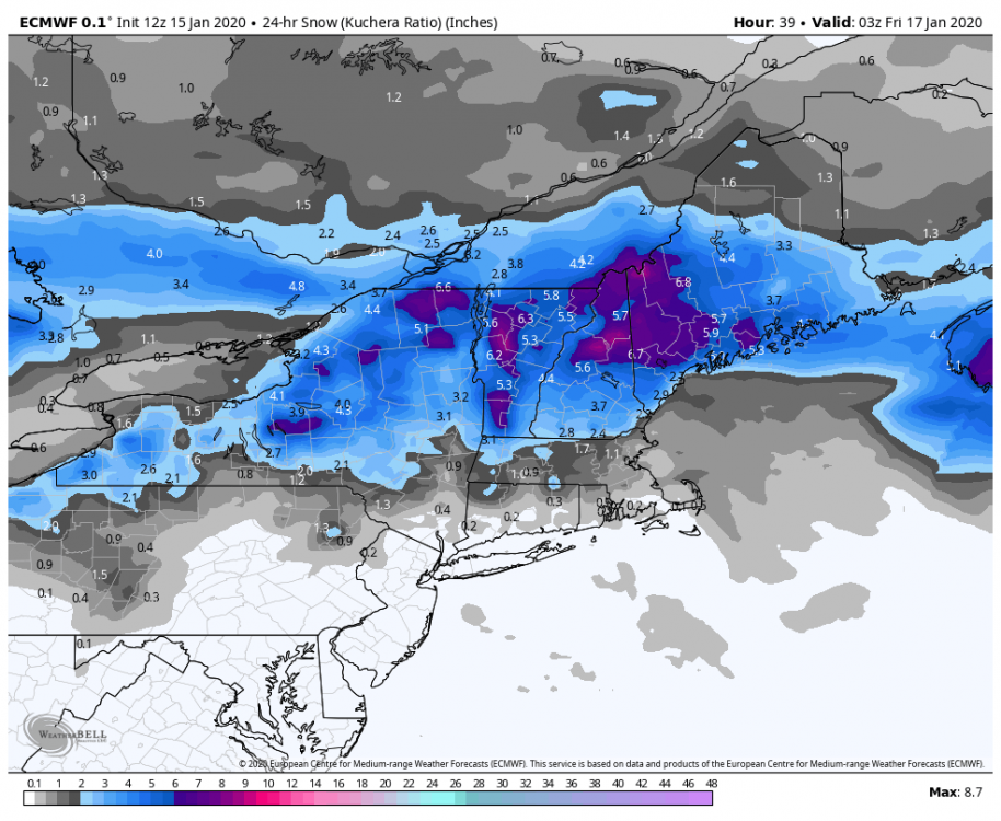
That is about as good a 5 day mean that far out will ever look. We see higher ens means but it’s always either a close range threat or over a longer period that includes multiple threats.