

GramaxRefugee
-
Posts
1,337 -
Joined
-
Last visited
Content Type
Profiles
Blogs
Forums
American Weather
Media Demo
Store
Gallery
Posts posted by GramaxRefugee
-
-

Probably not a great picture, but I noticed the cherry reached blossom last year on April 6, (when I took the same photo), so blooms are running 1 week later this spring than 2023.
It's been so windy the tree is hard to photograph.
-
 2
2
-
-
This morning; tide height on the South River is highest I've seen in a few years. (Wish I could give a more numerical description)
-
Cherry trees just budding at my location. Walked the dog up the hill last night, and same buds have opened. A little sun and I could have some flowers by next week.
-
39 minutes ago, Mrs.J said:
So the older Ms. J is in a scriptwriting class this semester. The next assignment is to write 3 pitches for PSA's. She was going to do Spay and Neuter your pets, but changed to Weather PSA's. We got into the discussion about how the NWS has changed up their wording recently so that the public takes it seriously. Will be interesting to see what she comes up with.
I hope you showed her some of @Jebman 's posts.
-
 2
2
-
-
-
58 minutes ago, stormy said:
2.54 " March total rainfall. This is only 72% of normal.
A rather remarkable statistic: 8 of the past 8 Marches have been drier than normal in my area. 100% dry in March during the past 8 years!!
7 of the past 8 winters have had below normal snowfall.
87% of the time during the past 8 years, low winter snowfall precedes a dry March west of the Blue Ridge.
The last wet March was 2015. During the winter of 14/15 I had above normal snowfall.
Before that, March of 2014 was wet. I also had above normal snowfall for the 13/14 winter!!!!!!!!!!!!
Your study seems to give you the ability to predict March precipitation based on DJF snowfall. But...
.... If you can find a way to make March (accurately) predict the following year DJF snowfall; well, that would certainly get attention.
-
March total here 5.52" (including a Trace of snow)
Highest temp 79f, lowest 24.
-
1
-
-
49f and heavy rain 7:45
T&L but limited to a few claps.
-
Pretty significant thunder lightning just hitting here about 10:15
-
1 hour ago, TSG said:
Oooo a topic I know well! I'll keep this short, I know it's off topic. The pervious vs impervious debate on solar panels has been happening in many states and the legislation typically falls well short of common sense... like a lot of things these days. My view as an engineer is they shouldn't be considered completely one or the other except for very specific cases. On a typical ground mount installation, the only truly blocked off portions of the ground are where foundations enter the ground/sit. The panels will of course redirect and concentrate rainfall a bit, but you have gaps between every panel where water can drip down to the ground below. Water running across the ground is also not prevented from entering the ground when running under panels. A more useful piece of legislation would take all this into account, but that would require doing more legwork to figure out. And lawmakers are lazy. So we get half-baked decisions like "totally impervious" or "totally pervious" when the truth lies somewhere in-between.
Rooftop/garagetop solar won't affect stormwater calcs since they're going on top of already impervious surface.
True to us sensible scientists, but not to State of Maryland. The only thing that redevelopment buys you now is cutting inches of rainfall from 2.2 (roughly) down to 1 inch. If you put impervious on impervious, you still have to do quality control (ESD) as of c. 2015. (Was phased in 50%, 75%, now 100%) . And, in Prince George's, as of 2019, you have to do quantity control too, even though you are replacing roof with roof.
Redskins stadium made some covered parking by making their carport roof out of PV panels. Clever.
VA is more sensible than MD. But I've long told clients...never try to make sense out of environmental laws.
-
1
-
-
19 minutes ago, bigtenfan said:
This!!
By the time that the enviornmentalist and their lawyers are done with this it will take 4 years to get permits!
About 8-10 years ago, MDE gave in to Big Solar and declared that PV panels are not really impervious, thus avoiding SWM for those thousands of acres of solar farms. I predict they do similar for new Key Bridge if it becomes a pet project of the State. Otherwise, you'd be right... no bridge for you.
-
Low of 30
I was also expecting warmer today than yesterday, but it actually was a degree colder.
-
Hit a low of 29f sometime after midnight, but was up to 33 at daybreak.
Red oak in the stove.
-
1
-
-
1.90" storm total here.
Winter air blowing back in now, DP down to 32
-
4 minutes ago, CAPE said:
The dry weather was nice while it lasted. Now back to the usual heavy, maybe excessive rain. The wind wont be trivial ether. Good old fashioned WEEKEND Nor'easter rainer for the MA.
Forecast here is for a half inch tonight and 2-3 tomorrow.
FYP
-
low of 27
still no frost. (DP 20)
-
Low 29f
(DP reached 12)
-
Light snow at 7:30 here in AACo.
Low was 31f.
-
On 3/13/2024 at 12:48 PM, Weather Will said:
Not over yet.....WB Day 12 or so both GFS and EURO have a storm and "Barney" purple cold is around.


March 1942 (Baltimore)... Temp anomaly was +2.8...Hit 76f on feast of St. Patrick.....22" of snow fell on 3/29/42. Same date also the lowest temp of the month at 33f. That's right, a 22" snowfall month in which the temp never fell to freezing.
-
Snow squall here at 16:40; was working outdoors and it caught me by surprise.
-
3 hours ago, Kmlwx said:
I'm torn on whether to root for a last minute freak snowstorm that makes me lose....or if I should just hope for the win at this point.
At this time of year, a heavy snow would be melted in a few days anyway. Winning Glory Never Melts.
However....2.5 inches at RIC, with a little bit at IAD would suit me fine.
-
Feb Total 1.62"
Highest temp 66, lowest 21
-
1
-
-
17 minutes ago, SnowenOutThere said:
If you have any old AFDs from our blizzards saved please do share them as unfortunately I am too young to have been able to read of them live...
Here's the 2016 storm as written by the legendary Paul Kocin. (For some reason it's been hanging around my hard drive for years)
http://www.wpc.ncep.noaa.gov/discussions/hpcdiscussions.php?disc=pmdepd
EXTENDED FORECAST DISCUSSION
NWS WEATHER PREDICTION CENTER COLLEGE PARK MD
1100 AM EST TUE JAN 19 2016VALID 12Z FRI JAN 22 2016 - 12Z TUE JAN 26 2016
HIGHLIGHTS...
LETS CUT TO THE CHASE. THE MAIN EVENT IN THE MEDIUM RANGE IS THE
POTENTIAL FOR A SIGNIFICANT EAST COAST SNOWSTORM FROM FRIDAY
THROUGH SUNDAY/DAYS 3 TO 5. THERE HAS BEEN AND CONTINUES TO BE
RELATIVELY GOOD AGREEMENT ESPECIALLY BETWEEN THE MODEL ENSEMBLES.
COMPARING THE OPERATIONAL RUNS TO THE ENSEMBLE MEANS DOES INDICATE
SOME DIFFERENCES THAT ARE SMALL IN THE LARGE SCALE BUT CRUCIAL TO
THE FORECAST. ALL MODELS SUGGEST THAT MAJOR DEVELOPMENT FOR THIS
SYSTEM WILL OCCUR AS IT MOVES TO THE MID ATLANTIC COAST AND THEN
THE SYSTEM OCCLUDES...BECOMES MORE VERTICAL AND THEN CONTINUES
NORTHEASTWARD WITH THE MOVEMENT OF THE UPPER TROUGH. WITH THAT IN
MIND...THE STORM WILL LIKELY SLOW IN ITS FORWARD MOVEMENT AS IT
MOVES OFF THE MID ATLANTIC COAST AND THEN WILL LIKELY ACCELERATE
NORTHEASTWARD OR ANOTHER TRIPLE POINT LOW MAY DEVELOP FARTHER
NORTH AND EAST. THE 00Z ECMWF SUGGESTS BOTH SCENARIOS. IN EITHER
EVEN...THE OVERALL SPEED OF THE SYSTEM IS IMPORTANT TO AFFECT THE
AMOUNT OF SNOW IN ANY ONE AREA. THIS WILL BE AN IMPORTANT TREND
TO FOLLOW AS THE MORNING MODEL SOLUTIONS START COMING IN.IN ADDITION...ANY TRENDS EITHER NORTH OR SOUTH WILL IMPACT
SNOWFALL AMOUNTS ALONG THE NORTHERN EDGE OF THE HEAVIEST SNOW AS
WELL AS THE ISSUES OF MIXING/CHANGEOVER ALONG THE SOUTHERN EDGE OF
THE SYSTEM. THERE HAVE BEEN SUBTLE NORTH/SOUTH SHIFTS WITH THIS
FORECAST BUT WILL HAVE TO BE ASSESSED WHEN THE MORNING MODELS
ARRIVE. THERE HAVEN'T BEEN LARGE CHANGES WITH THE OVERNIGHT CYCLE.IN GENERAL...THE OPERATIONAL GFS RUNS ARE SLIGHTLY MORE
PROGRESSIVE THAN THE OPERATIONAL ECMWF RUNS. IN PARTICULAR THE 06Z
GFS TRENDED FASTER THAN PREVIOUS RUNS RESULTING IN LOWER SNOWFALL
AMOUNTS DUE TO LOWER SNOWFALL DURATION. THE 00Z UKMET IS SIMILAR
TO THE ECMWF AND TO SOME EXTENT THE GFS BUT THE 00Z CANADIAN WAS
MUCH MORE PROGESSIVE THAN ANY OTHER MODEL AS WELL AS THE CANADIAN
ENSEMBLES. AS A RESULT...LATER IN THE FORECAST...THE NAEFS MEAN
IS FASTER THAN THE GFS MEAN DUE TO THE CONTRIBUTION OF THE
CANADIAN SOLUTIONS. AT THIS TIME...THE HIGHEST PROBABILITIES FOR
THE HEAVIEST SNOW BETWEEN THE ISSUES WITH THE NORTHERN EDGE AND
THE SOUTHERN MIX/CHANGEOVER IS CURRENTLY SUGGESTED TO RUN FROM
NORTHERN VIRGINIA TO EASTERN PENNSYLVANIA/NEW JERSEY INTO SOUTHERN
NEW ENGLAND.TO PUT THIS SYSTEM IN CONTEXT...THE POTENTIAL SNOWFALL
DISTRIBUTION HAS SIMILARITIES TO SEVERAL MAJOR EAST COAST STORMS
IN RECENT PAST INCLUDING THE 5-6 FEBRUARY 2010 SNOWSTORM/THE
JANUARY 1996 BLIZZARD OF 1996 AND THE PRESIDENTS DAY OF FEBRUARY
2003. JANUARY 1996 IS LIKELY TO BE MORE WIDESPREAD/HEAVY BUT ONLY
TIME WILL TELL. THE MECHANISMS COMING TOGETHER FOR A MAJOR
SNOWFALL ARE TEXTBOOK.IN THE WEST...PRECIPITATION SHOULD WANE ALONG THE COAST DAY 3 INTO
DAY 4...WITH THE NEXT MAJOR PRECIPITATION EVENT EXPECTED ACROSS
THE PACIFIC NORTHWEST BY NEXT MONDAY OR TUESDAY...WITH SEVERAL
INCHES OF LIQUID EQUIVALENT EXPECTED.CONFIDENCE...
THIS IS A HIGH CONFIDENCE EVENT THIS FAR OUT IN ADVANCE BUT THAT
ALSO SUGGEST THAT SMALL CHANGES CAN HAVE SIGNIFICANT CHANGES TO
IMPACT. THERE IS STILL 3 TO 4 DAYS FROM THE EVENT AND MANY MODEL
SOLUTIONS TO COME. THERE HAS BEEN EXCELLENT CONTINUITY RELATIVE
TO AVERAGE AND PERHAPS SIMILAR TO WHAT WAS OBSERVED WITH THE
FORECASTS PRIOR TO 5-6 FEBRUARY 2003...WHICH WAS FORECAST AS MUCH
AS 8 DAYS IN ADVANCE. OTHER STORMS HAVE BEEN MUCH LESS
PREDICTABLE. THIS MAY BE ONE CASE WITH A HIGH DEGREE OF
PREDICTABILITY BUT WE SHALL SEE.KOCIN
-
5
-
-
2 hours ago, Jebman said:
Not really sure why visibilities are getting so low on woolly camera at Mammoth. Winds are increasing a lot. That wind is beginning to take on a kind of milkshake froth appearance. Not really understanding what I am seeing here. Okay there is some increase in areal coverage of snow on the woolly lot. It is blowing around a lot more than it did at 3am my time. Winds are gusting to damaging speeds. If snow is actually accumulating, it will be extremely difficult to measure because of 90 mph gusts.
I am not hugging the gfs. This snow is probably only a brief shower or two. This storm is a day late and one hell of a dollar short! We shall see but I am not fooled by the goofus's siren song of 10 to 12 feet. That is pure nonsense. Maybe a foot for Mammoth over the next 10 days including the next storm later next week. I threw that useless gfs out! It's an outlier.
They seem to have measured gusts at 145mph..
https://forecast.weather.gov/product.php?site=rev&issuedby=REV&product=PNS
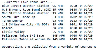
Notice how their gadget drops the highest to the bottom because its not set for 3 digit measurements.
-
1
-


April Discobs 2024
in Mid Atlantic
Posted
0.02" of rain. High temp 55f.