stormy
-
Posts
1,009 -
Joined
-
Last visited
Content Type
Profiles
Blogs
Forums
American Weather
Media Demo
Store
Gallery
Everything posted by stormy
-
Rain with the incoming system focuses north of I-70.................................. Not a good trend.........
-
Mother Nature always balances. Syracuse has only had 31% of climo, DC has had 84%, I have had 29%. I am happy, that is 28.6 % more than last year. Rejoice and be happy with your blessings.
-
What Went Wrong in Winter 23-24/Base State/Will It Ever Snow Again??
stormy replied to WxUSAF's topic in Mid Atlantic
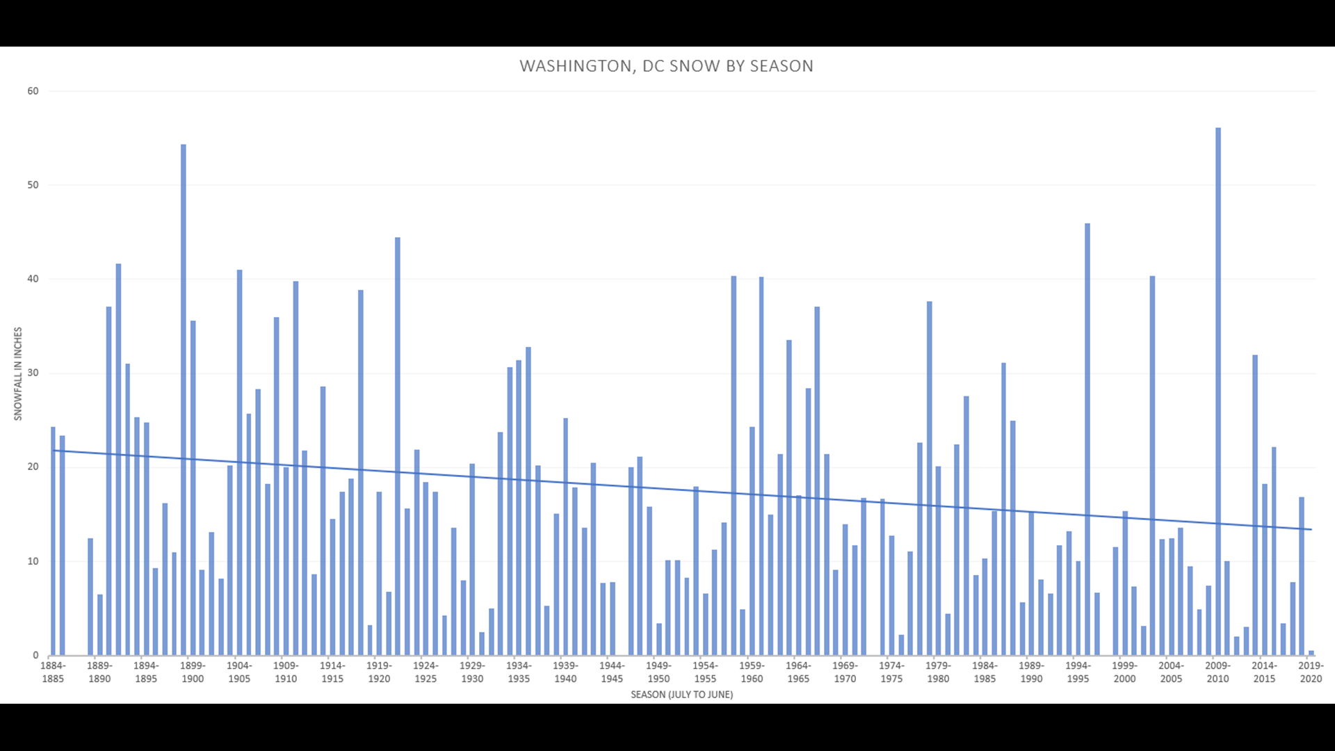
The immediate DC region is closer to normal snowfall this winter than the great majority on the east coast according to NOAA. DCA 8.5 received, average ann.total 13.7 = 60%, Pittsburgh 13 received, average total 42 31%, Philadelphia 10 received 19 average 53%, Staunton 7 received 24 average 29%. This makes some people happy and some unhappy. There has been a gradual downhill slide in D.C. snowfall for 140 years according to this data, but look at the wildly fluctuating seasons with the recording breaking season not 100 but only 14 years ago. We should be getting close to another big year.
-
17.5 degrees at 7 am. That's 9 degrees colder than normal.
-
What Went Wrong in Winter 23-24/Base State/Will It Ever Snow Again??
stormy replied to WxUSAF's topic in Mid Atlantic
Bob, Thank You!! I always enjoy reading your down to earth wisdom. I only received .25 inch of snow but that is fine because I have about 7 weeks to go. My greatest prayer in November was to have a wet winter to rebuild the water table. That has happened. According to NOAA , many in the DC area are now around 100% of normal snowfall to date. DC has been very lucky this winter!! As you said recently, Mother Nature really has not wanted to snow this winter along the east coast. Just look at these snowfall percentages of normal for this winter: Roanoke 40%, Richmond 11%, Blacksburg 21%, Pittsburgh 38%, Cleveland 38%, Scranton 61%, Concord N.H. 70%, Buffalo NY 76%, Caribou Maine 75%. -
What Went Wrong in Winter 23-24/Base State/Will It Ever Snow Again??
stormy replied to WxUSAF's topic in Mid Atlantic
Be patient, it will happen. -
The Weekend Rule? Saturday 2/17 - The Icon Storm
stormy replied to DDweatherman's topic in Mid Atlantic
Since this morning, the 6 model blend for DC has dropped from 3.7" to 3.0". The 6 model blend for Augusta/Rockingham has dropped from 3.1 to 1.8". -
The Weekend Rule? Saturday 2/17 - The Icon Storm
stormy replied to DDweatherman's topic in Mid Atlantic
2 - 4 was my call last night. Did I find a nut?? -
The Weekend Rule? Saturday 2/17 - The Icon Storm
stormy replied to DDweatherman's topic in Mid Atlantic
Good News!! The 3 model blend for DC increased from 2.6 to 3.4. A new 6 model blend for DC is 3.7". This is the GFS, ECM, GEM, ICON,NAM3 and NAM12. Kuchera For west of the BR, this 6 model blend is 3.1". -
The Weekend Rule? Saturday 2/17 - The Icon Storm
stormy replied to DDweatherman's topic in Mid Atlantic
THE WSW IS NUTS!!!!!! -
The Weekend Rule? Saturday 2/17 - The Icon Storm
stormy replied to DDweatherman's topic in Mid Atlantic
My final call: 2-4 for most in this subforum -
The Weekend Rule? Saturday 2/17 - The Icon Storm
stormy replied to DDweatherman's topic in Mid Atlantic
I am very happy to read this! -
The Weekend Rule? Saturday 2/17 - The Icon Storm
stormy replied to DDweatherman's topic in Mid Atlantic
You are exactly right my friend out here on the western front!.. .39 is indeed in the .35 - .55 range. This was for PSU and you nailed it. I'm just playing semantics, don't you understand? -
The Weekend Rule? Saturday 2/17 - The Icon Storm
stormy replied to DDweatherman's topic in Mid Atlantic
You admit that you follow him. What more needs to be said??? -
The Weekend Rule? Saturday 2/17 - The Icon Storm
stormy replied to DDweatherman's topic in Mid Atlantic
The latest GFS doesn't like your ideas. Only .23.- .39 -
The Weekend Rule? Saturday 2/17 - The Icon Storm
stormy replied to DDweatherman's topic in Mid Atlantic
The GFS is a little more amped at 18z and consolidates over NC. GOOD RUN! -
The Weekend Rule? Saturday 2/17 - The Icon Storm
stormy replied to DDweatherman's topic in Mid Atlantic
I hope!!! -
The Weekend Rule? Saturday 2/17 - The Icon Storm
stormy replied to DDweatherman's topic in Mid Atlantic
Thanks for this from DT -
The Weekend Rule? Saturday 2/17 - The Icon Storm
stormy replied to DDweatherman's topic in Mid Atlantic
The ICON and NAM have both shifted significantly north at 18z -
The Weekend Rule? Saturday 2/17 - The Icon Storm
stormy replied to DDweatherman's topic in Mid Atlantic
Will DC become a snow-town Friday night?? This chart reveals very interesting data through Tuesday Caribou, Maine has only received 75% of normal snowfall this 23/24 winter while DC has received 85% of normal. What does this say? Lack of snowfall is more than simply a lack of cold air. Other factors are involved. By the way DC only has about an inch and a half to go over climo to date Friday night!!! -
The Weekend Rule? Saturday 2/17 - The Icon Storm
stormy replied to DDweatherman's topic in Mid Atlantic
Anything coming from the Texas, Panhandle always has potential. -
The Weekend Rule? Saturday 2/17 - The Icon Storm
stormy replied to DDweatherman's topic in Mid Atlantic
The 3 model Blend for DC has ticked up from 1.9 to 2.6 inches since 8 am. The same Blend has ticked down west of the BR from 3.1 - 2.9". -
The Weekend Rule? Saturday 2/17 - The Icon Storm
stormy replied to DDweatherman's topic in Mid Atlantic
My latest 3 model blend for DC is 1.9 inches, Kuchera, GFS ECM GEM. West of the BR, Staunton to New Market is 3.1". -
Statistics are always fascinating to me. The very interesting thing here is that Caribou,Maine has only received 75% of normal snowfall while DCA has received 85%!!! There is much more at issue here than simply being too warm. Thanks for posting this very revealing information!!
-
The Weekend Rule? Saturday 2/17 - The Icon Storm
stormy replied to DDweatherman's topic in Mid Atlantic
GFS much better than NAM