

Scott747
-
Posts
3,251 -
Joined
Content Type
Profiles
Blogs
Forums
American Weather
Media Demo
Store
Gallery
Posts posted by Scott747
-
-
While the thread isn't in 'storm mode' there definitely needs to be a little more constructive posting that's storm specific. Also over the next few days as Lee is producing some eye candy refrain from quoting any imagery with one liners. Chances are it's going to be deleted. All it does is clog up the thread.
-
 12
12
-
 2
2
-
 1
1
-
-
We're at the point leading up to landfall that if it isn't some solid analysis or discussion then expect that the posts will be removed.
Chit chat, predictions, one word responses etc. should go into banter.
-
10
-
7
-
 1
1
-
-
33 minutes ago, Ed, snow and hurricane fan said:
OT 3rd time in a day I get a notification @ldub23 has quoted me in this thread, and when I look, there is no quote. I wonder if he is replying, and them immediately deleting just to make me look.
Those posts have gone away because it's the same schtick as it always is.
In a nutshell that poster has cancelled the rest of August and September. Also October will be cancelled along with 2024, 2025 and beyond.
-
4
-
5
-
9
-
-
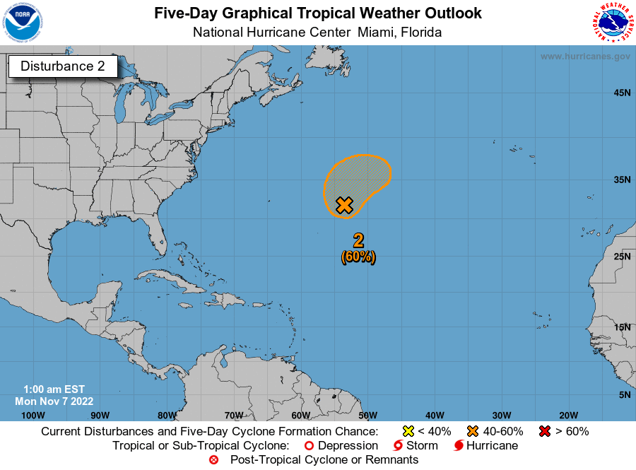
Tropical Weather Outlook
NWS National Hurricane Center Miami FL
800 PM EDT Tue Aug 15 2023
3. Western Gulf of Mexico:
A broad area of low pressure could form in the central or western
Gulf of Mexico by the beginning of next week. Some slow development
of this system is possible thereafter as it moves generally
westward, potentially nearing the western Gulf of Mexico coastline
in about a week.
* Formation chance through 48 hours...low...near 0 percent.
* Formation chance through 7 days...low...20 percent.

-
2 hours ago, ldub23 said:
The overall pattern will have to reverse for that to matter.
In what is potentially shaping up to be a boring and below average year... We don't need your same schtick telling us it's going to be a boring and below average year.
-
4
-
-
14 minutes ago, cptcatz said:
Anyone know when the next low level recon is?
Should be taking off soon and making a pass or two before this afternoon's package.
-
1
-
-
Take the NAM disco to banter.
-
5
-
6
-
5
-
 2
2
-
2
-
-
About a 2-3 mb pressure drop on latest fix.
Official upgrade won't be till the next update in an hour or so.
-
1
-
-
Looks like it has been upgraded in the database...
-
1
-
-
Could be one of those 'bombs away' kinda night.
-
5:00 AM AST Fri Sep 23
Location: 13.9°N 68.6°W
Moving: WNW at 13 mph
Min pressure: 1006 mb
Max sustained: 35 mph
-
1
-
-
0z GFS is NC-17 for Galveston.
-
1
-
-
Behaving as expected. Modeling has backed off somewhat the last couple of days and showing more of a stretched out system with no dominant center between the lower and mid Texas coast. At least there is a 'tropical' feel between the wave action and winds/cloud cover that is bringing some relief from the heat and eventual rain across parts of the area.
-
Models have been flirting with the potential of a quick spin up off the Texas coast early next week. Seems a toss up right now of an organized tropical system, but should at least bring some well needed rain across parts of Texas.
-
1
-
-
Meh so far.
Maybe 35 sustained and 50 gusts at the casa.
Took a dip down near the coast about an hour ago and it was about 40-45 sustained and 60 gusts. Probably getting a little rougher down there these last 30 minutes.
-
1
-
-
Leading up to landfall in these last few hours and if it isn't some heavy hitting analysis or solid contributions and you see your posts removed...
That's a good hint to take it to the banter thread.
-
12
-
2
-
5
-
1
-
6
-
-
This special
advisory is issued to raise the 12-hour forecast intensity to 135
kt, but it is possible that Ida could peak slightly above that
before landfall occurs.
-
5
-
1
-
-
AF305 will be making a pass in about 15 min.
Currently approaching the eye.
-
1 minute ago, dseagull said:
The responses to my opinion speak volumes. It was an OPINION. If you wish to censor opinions, feel free to do so, but at least acknowledge that debate leads to progress. Would it be fair to assume that you are progressive? If you censor and ignore opposing viewpoints, how will you ever attain progress? It is quite disturbing that you feel I am to be labeled a climate change denier. I never denied climate change. I simply deny that humans have any "real" effects on such. I'll leave you guys to it. Sorry for offering a professional perspective.
It had no business in the main thread.
'Opinion' away in this thread.
-
2
-
-
Josh is moving up the coast. Should be a fun drive....
-
2
-
-
41 minutes ago, wxmx said:
Yes, now I have this image in my mind
That's what it's going to look like too after landfall once it hits those mountains. The disintegration of Karl was pretty amazing.
-
5 minutes ago, MJO812 said:
I'm seeing 995
Where are you seeing 989 ?
Low-level Reconnaissance
-
That's 0z guidance based on 18z models...
-
24 minutes ago, eyes2theskies said:
pretty big swing to the east on the 00z models
What 0z models?
Category Five Hurricane Lee
in Tropical Headquarters
Posted
At least compared to the HWRF/HMON the HAFS was about 15% better on track while it was in the experimental phase the last few years and only expected to improve. So any shifts they show should be noteworthy.