
Bob Chill
-
Posts
35,665 -
Joined
Content Type
Profiles
Blogs
Forums
American Weather
Media Demo
Store
Gallery
Everything posted by Bob Chill
-
 There's putting a cart before the horse and then there's Ralph. Worrying about a storm destroying future storm chances in a disastrous winter does not compute anywhere in my head. Might need a crtl/alt/delete or something
- 2,529 replies
-
- 15
-

-

-

-
- weenie fest or weenie roast?
- weenies got roasted
- (and 2 more)
-
Just don't include that with "the socks" album cover
- 2,529 replies
-
- 3
-
-
-
- weenie fest or weenie roast?
- weenies got roasted
- (and 2 more)
-
Found a good use for snow maps lol. Good visual here of last 7 gfs runs for vday period. Scattershot/unresolved at first but last 4 runs show a clear trend and it's caused by upper air patten trying to find any way to press down into this wave. Yea, temps are disastrous I get that but we're in a state of massive flux in the high latitudes. There is still a real opportunity. Until that vanishes it's hard for me to look beyond. This isn't a setup you can just dismiss yet imo only
.thumb.gif.ed9eb2c7994320bbaab461d93c564b34.gif)
- 2,529 replies
-
- 12
-
-
-
- weenie fest or weenie roast?
- weenies got roasted
- (and 2 more)
-
With the longwave flow in major flux above us, and acknowledging that the last 2 times this happened (both directions) models all jumped to new conclusions inside of 10 days, it's worth keeping a completely open mind to the VD period. The ingredients are there but dicey (as always). But the path to victory is perfectly logical and has happened b4. @Jiyou mentioned 2015 type storms. Yea, I remember a few in more detail now. One in particular. Wave running into a cold press. Temps went from not great leading in to actually too much cold arctic air pressing down and it pacman'd the northern edge really bad. It surprised us a little. Those "press" type of setup do happen here. The VD period is a longshot but if it sets up it's not complicated
- 2,529 replies
-
- 5
-
-
-
- weenie fest or weenie roast?
- weenies got roasted
- (and 2 more)
-
The 80s has some good storms like this iirc. 2015 had weird blocking but we definitely got striped like a train track. I was thinking yesterday how how terrible the 14 day AO forecasts have been this winter. The big moves were missed badly beyond 10 days. Outside of normal bad range too. AO is tanking faster than predicted now. GFS could be right but it's messy with temps no matter.
- 2,529 replies
-
- 1
-
-
- weenie fest or weenie roast?
- weenies got roasted
- (and 2 more)
-
I like these setups. Shortwave isn't crazy strong and confluence is backing down into it. Everything has to smash into each other just right but there's wiggle room. Just need the confluence to set up right. It can happen before or during the approach. We have some good history with this stuff.
- 2,529 replies
-
- 11
-
-
- weenie fest or weenie roast?
- weenies got roasted
- (and 2 more)
-
Idk. We can barely figure out next week. Maybe somebody knows something but I'll wait until late Nov before discussing it.
- 2,529 replies
-
- 11
-
-
-
-
- weenie fest or weenie roast?
- weenies got roasted
- (and 2 more)
-
I'm 100% stoked on the AO/NAO. Mid Jan was a gut punch with the hit and run. That was unusual. So much so I don't remember seeing a rapid flip from dep neg to deep positive. Oscillations are normal/expected. That wasn't an oscillation. It was a bowling ball on a trampoline. Considering length of lead and laser focus throughout, this current potential blocking event looks much more classic and stable. If that's the case, we can probably expect a decent -AO/NAO on the means for 45 days. Maybe longer but 45 gets us thru March. Maybe coincidence (again) but met winter sure seems to have moved forward 2 weeks last 8 years or so. Maybe this winter is progressing as previous just not following the calendar. Beats me but Mar 24 will likely be another memorable and recent March. How long was the big block in place b4 the first Feb storm in 2010? We were cold and dry for a while before the late Jan storm. I remember the big relax after Dec 19th but when it came back it never left until late Feb.
- 2,529 replies
-
- 5
-
-
- weenie fest or weenie roast?
- weenies got roasted
- (and 2 more)
-
I'm leaning towards the front half of March to be the most active. Ens guidance did an incredible job seeing the blocking pattern. One thing I never liked seeing is the corresponding precip anomaly panels. Second half of Feb has looked pretty dry with unanimous agreement. Now that it's getting closer it's looking more likely. We can still get a big storm as the pattern itself is ripe but idk. BN precip anomaly in the TN valley across all weekly/monthly guidance is bugging me. Pretty strong clue of suppressed storm track and/or quiet northern stream. That narrows our path to true Miller A's that have to turn the corner. NW shield would be tight and track more on the vertical side. I can't think of many pure Miller As without a primary in the tn vly. Jan 2000? Lol Eta: I graphed a bunch of nao data leading into our bigger storms. This was back in like 2012 so there is new data but the basic premise was obvious. We don't get big snow with a real -NAO descending into anomalous territory. We generally dont even get moderate snow with a tanked-NAO. There are a few but vast majority are on the relax. Most know this. This is a massive blocking event. That's not our forte on the front side.
- 2,529 replies
-
- 11
-
-
- weenie fest or weenie roast?
- weenies got roasted
- (and 2 more)
-
This is why I'm not engaged. I don't doubt a good snow pattern showing up (I'm as certain as anyone) but without snow it will feel like average boring late winter. Chilly in the wind, warm in the sun, daylight dinners and frosty mornings. If we were tracking an arctic blast like 2015, I'd be a laser. Once I see something that has higher odds than another longshot letdown, I'll be locked and loaded. Maybe this month, maybe March, or maybe next winter lol
- 2,529 replies
-
- 10
-
-
- weenie fest or weenie roast?
- weenies got roasted
- (and 2 more)
-
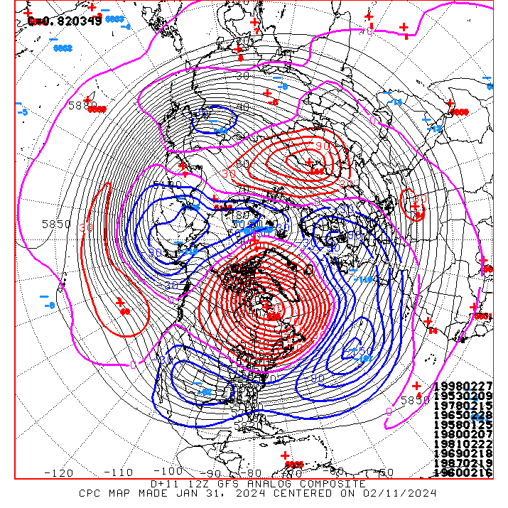
For reasons above my pay grade, this entire winter never had a good analog set except for the time it snowed. Even when the mean looked good at times, nothing good ever matched. Imo- this year is far less a warmer earth problem than it is just a stubborn bad winter. Most of the analogs the whole trip this year have showed that over and over. You can take long lead op runs that look good and still come up with a bunch of turd periods. Very frustrating but far from uncommon. We've had plenty like this in the last 80 years. This is just an example. I know long lead ops are the last upper air pattern to pull analogs from but even with a very good look like this... the match dates kinda suck lol
-
I'm absolutely not convinced about a west track rain around the 12th-15th. Only how it looks to me right now. We've had a ton of rain last 2 months so dry hasn't been a problem at all. Would be a real ass chapper if we get a couple weeks of good air with no precip to mix with it lol
-
I think I figured out what I didn't like under the hood. My best guess right now based on everything I see is the pattern flip will preceded by a west track rain/front sometime around the 12-15th then we go dry for a bit and wait for something to undercut the pna. Guidance is kinda dry after the trough hits and it seems to last. If the northern stream is quiet and all precip events are lower slower southern stream waves, there's typically a 5-7 day gap in between. Maybe the goods are still a week beyond where ens guidance ends. Looking forward to the flip getting closer so I can track analog guidance. Analogs still look pretty bad irt snow chances
- 2,529 replies
-
- 1
-
-
- weenie fest or weenie roast?
- weenies got roasted
- (and 2 more)
-
Jan/Early Feb Medium/Long Range Discussion Part 3
Bob Chill replied to WinterWxLuvr's topic in Mid Atlantic
Complicated... lol. If the low stays completely separate from the northern stream like most guidance shows, a flush hit carries a huge risk of flush rain. Thermals are awful without stream interaction. Can that still happen? Sure, it's in the envelope. But getting stream interaction downstream is backwards. We need to tap downstream and pull cold nearly backwards. Idk man. That's a tall order lol -
Jan/Early Feb Medium/Long Range Discussion Part 3
Bob Chill replied to WinterWxLuvr's topic in Mid Atlantic
That's been happening since I started tracking. Reasons are simple. Storms want to gain latitude. It's their job. Strength of storm is never resolved so as storms look "better" or stronger as lead times shorten, there's like an 88% chance it fights to push north. Without a transient big block or more classic blocked flow, storms will always butt against walls and usually bully them a little. Happens both ways though. A good storm in the mid range that weakens will almost always end up south (or get squashed into dark matter lol). Blocked flow can easily push a storm south in the mid to short range. And that's certainly happened. Congrats short pump was born in that setup lolol Eta: one more thing. Op models appear to have a bias with depth of cold in the mid range. Fronts rarely push as far south as initially modeled and cold moderates more than expected. This is often a result of cold taking longer than expected to bleed east. -
Jan/Early Feb Medium/Long Range Discussion Part 3
Bob Chill replied to WinterWxLuvr's topic in Mid Atlantic
There's 2 separate schools of positive winter thoughts/discussion happenin and it can be hard to filter lol. I think most everyone agrees that getting no more snowfall is far less likely than getting 1 (or dare I say 2) additional accumulating snowfalls. More is always better lol but I don't see how we don't add to our totals without a complete reversal of how we currently see late Feb followed by a shitblinds March. Nobody is canceling that except for the notorious Schleprocks we have around here goin' all wowzee wowzee woo woo (wah wah lol). Where things are degrading is big storm optimism. We know our yards real well here. Uphill climo starts in earnest around the 3rd week of Feb and then big anomalous patterns are required in March. Doesn't mean we can't or won't get shellacked but history has a lot of arguments about a big finish once we cross into that 3rd week. The ironic thing this year is that even if we were to get a single 12" storm in late Feb, the winter appeal of our Jan magic week will put it to shame. Lol. Kids were sledding packed powder for 7 straight days with full coverage. South slopes took forever to go brown. 12" on Feb 23rd? Man, you better have your camera ready and take first run on the sledding hill cuz that appeal will last 48 hours tops and will likely be potatoes within 24 -
Jan/Early Feb Medium/Long Range Discussion Part 3
Bob Chill replied to WinterWxLuvr's topic in Mid Atlantic
Oh trust me, i definitely have my radar on and am absorbing everything because this stinker period has a different feel. Kinda feels like this is normal now. Lol. Recency bias in play but still... there are trouble signs. The one thing I keep getting stuck on is warm oceans and gulf and how they effect winter storm track.... it sure seems hard to get anything to track under us from the northern stream now... always riding the edge and one of the reasons the SE has been suffering. They prob do better than us with a deep digging northern stream but it sure doesn't want to dig with a shortwave embedded lolol Eta: maybe the clipper drought is part of this. We say there's a clipper drought but I've seen a bunch skip us to the north last 5-7 years -
Jan/Early Feb Medium/Long Range Discussion Part 3
Bob Chill replied to WinterWxLuvr's topic in Mid Atlantic
Looking at h5 means I agree. But the mean isn't catching the flaws imo. So if this year is a sign of a pattern not working, then it includes Philly, NYC, and SNE. Can't get behind that yet. It's a aberration to me more than a sign. The "breaks" basically. If we're were raining when we shouldn't (oh boy there's been a lot of rain lol) and Philly or NYC kept piling up snow, that would make me think differently. Analog guidance has consistently shown mixy/messy/flawed since Dec 1st. The one time it lit up it snowed twice. The repetitive analog years have been bad too. Over and over with no signs of big storm history hitting the wires. Majority of the repetitive analogs were from the not great 60s winters and 80s were always there. The more recent analogs like 04 showed up a lot too. A good analogy is 92/93 and 13/14. Incredibly similar H5 pattern with incredibly unsimilar results. Fine details often make or break us as we are right on the edge of good snow climo and no snow climo lol. Maybe another Nino or hudson high pattern shows up and snows instead of rains. Wouldn't surprise me but this year doesn't want to work in the east and it's persistent -
Jan/Early Feb Medium/Long Range Discussion Part 3
Bob Chill replied to WinterWxLuvr's topic in Mid Atlantic
Next 10 days looks like a variation of Dec with the central/eastern Canada blocking ridge. I never want to see one again lol. H5 mean plots in the rear view will look "good". PSU illustrated that earlier this month. But ground truth is anything but. We don't see that type of setup much and I learned something.... It will prob never be cold enough for snow when the streams stay separate in this regime. When they do, they keep the warm and cold air all neat and bottled up away from each other with no mechanism to mix. . So it requires a phase of sorts to pull down workable air. But phasing also curls storms and a big flat Canadian ridge really isn't a block as much as a guardrail. So the phase requirement introduces significant storm track risk. Idk man. The longwave pattern has been hostile for east coast snow door to door so far except for fits and spurts. Sometimes it's just how it goes and not some big lesson or evidence of trouble in years to come. That's where my head is. I don't see this year as some big scary piece of evidence to fear the future. We get a lot of rain and warmth on the winter. The early 80s were terrible for that stuff. I mean TERRIBLE. This winter has reminded me of those stinker periods. -
Jan/Early Feb Medium/Long Range Discussion Part 3
Bob Chill replied to WinterWxLuvr's topic in Mid Atlantic
I'd be happy with a -ao of any strength, neutral NAO, and +pna. Just give us 14 straight days of that. It may not end up like 2003 but that type of pattern is what i personally think is most likely to deliver at this point. If we were going to get real nao help, we've typically already had several cycles or one long one. The hit and run we just had was a bubble buster for me. Stable blocks in general don't do that. They oscillate with a bias. This winter hasn't shown any of that from how i look at things. I not poo poo'ing anything though. Things look totally fine for winter wx in Feb. I'm just not excited with what ens are showing irt big storms. Weekly and monthly guidance leading into this winter had plenty of stable blocking ideas and they still do but we haven't actually had any yet lol. And winters with stable blocking show their hand earlier than Feb 1st in general. I understand that Feb has always had the strongest signal. No argument from me. But it's perfectly logical for me at this point to assume the NAO prob isn't the feature that pushes this winter into the "big" category. I'd pay money to be wrong tho hahaha -
Jan/Early Feb Medium/Long Range Discussion Part 3
Bob Chill replied to WinterWxLuvr's topic in Mid Atlantic
The pattern is flipping around and mostly on schedule from what I see. I just don't like what I see under the hood. Storms have been curling early and easy this year and cold has mostly just been a blast that moderates without a cycles of reinforcement (except for the 10 days we got 2 quite lucky storms). Basically, guidance never shows a good spread of ingredients that hang out for a few cycles in the east. I haven't been a fan of analog guidance at all this year except for the 1 period where it snowed. Always showing mixy/messy when ens guidance shows something much more promising. Idk. I'm mostly going off my gut instincts to what I see. My personal algorithm has only been set off once this year and that's 8 weeks of tracking lol. When it goes off again, I'll be here shotgun posting lol Eta: Important detail... I'm talking about bigger storms in a real pattern. Not a normal climo choas event or any moderate event. Something that checks off boxes and pastes the coast is about the only thing that can turn this winter around for the majority. Not feelin that yet -
Jan/Early Feb Medium/Long Range Discussion Part 3
Bob Chill replied to WinterWxLuvr's topic in Mid Atlantic
I hate doing it and always want it to fail but for some reason simply adding a week to any meaningful longwave pattern change (meaning the change puts us in a pattern that can snow a few times) nails it like 80% of the time compared to just using ensembles. When things degraded my stupid gut said the way out will be difficult.... gah We're not really that close to discussing anything other than being in the game down the line imho. We can walk right into an event during the next 7-10 days but it's more climo than pattern driven (imo again). A stable pattern that keeps cycling us in the game has been quite elusive this year. Up and down the coast really. Sure would like to see that general personality change pretty soon. Otherwise I have a hunch storm track will continue to be a fight for the balance of remaining winter. Just spitballin but this is not a year for the east, period. The season has spoken loudly and it's basically Feb now. -
Jan/Early Feb Medium/Long Range Discussion Part 3
Bob Chill replied to WinterWxLuvr's topic in Mid Atlantic
People sensationalize EVERYTHING nowadays. Gotta yell at the sky and your followers right?! Lol. Gotta be first too! Haha. It is a crappy snow pattern and it is happening as modeled. The way out has remained locked in. Doesn't have to be a scorch the earth and leave charred remains to be a terrible snow pattern. Imo, bigger deals are too often made with just about everything since the internet became more important than reality. Hahahaha -
Here's the thing Rev, we all view the world through our own lenses/perspectives. We just walked out of an 8 day snow covered stretch mostly below freezing with 6-12" of snowfall in one week. Full coverage of excellent sledding and hiking snow for an entire week+ and the scenery was outstanding. That simply doesn't happen here often at all and that's a hard fact. It was a remarkable winter week in any winter. And what you are criticizing is people enjoying and being satisfied with a rare and beautiful anomalous week of winter weather. You obviously hated it and and nearly every post you make is a glass half empty. And you really want people to see it your way. Majority of people are actually optimistic on the balance and can be satisfied with the small things in life. Instead of criticizing that, maybe.... maybe consider trying to add some of that into your life. Satisfaction and happiness is a free will choice that we all make every single day. It's free, harmless, and the payoff is huge.
.gif.7f94429af6d0348d260e6c06cf996f99.gif)
