

ARyan
-
Posts
215 -
Joined
-
Last visited
Content Type
Profiles
Blogs
Forums
American Weather
Media Demo
Store
Gallery
Posts posted by ARyan
-
-
The HRRR has been trending towards expanding the ZR region NE along the NC/SC border over the past 5 runs or so. Doing a quick glance at the 17z initialization, it appears to be initializing correctly. It'll be interesting to see if this trend continues.
https://weather.cod.edu/forecast/?load=prun&prunType=2022011517-HRRR-SE-prec-ptype-18
-
...and back to sleet. Here's a live look from 700mb.

-
 3
3
-
-
Huge flakes. They're hitting the ground and rolling like tumbleweeds. (Okay. That's a bit of an exaggeration.)
-
Trying to go back to all snow. Still a few sleet pellets mixed in.
-
Some sleet mixing in but still mostly snow in Long Beach.
-
Just now, weatherbear5 said:
I think you’re confusing the mixing ratio line with the 0C temperature line
Yes. Thank you. I need another cup of coffee. I was just about the edit my post. Haha.
-
1
-
-
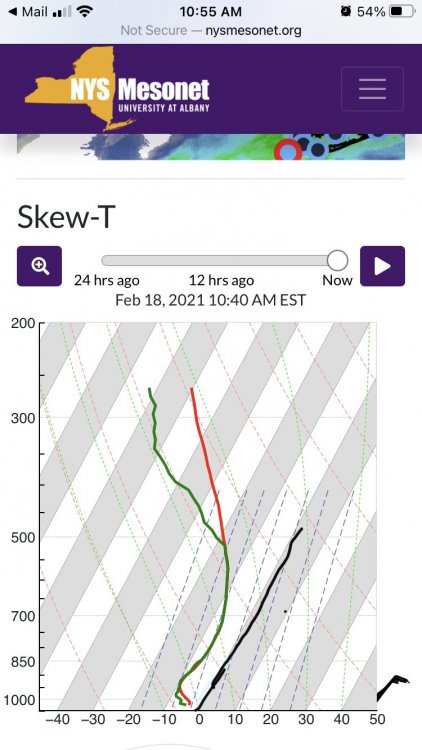
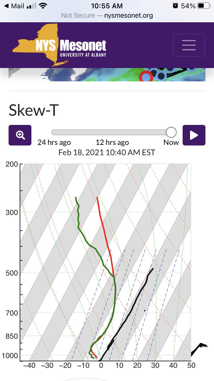
LIDAR soundings in the metro are already looking sketchy. Temps in the 700mb level are flirting with 0C. The heavy snow will help, but if/when things lighten up is when we'll be in trouble.http://www.nysmesonet.org/networks/profiler#stid=prof_stat
EDIT: I need another cup of coffee. Not nearly as close as I first interpreted.
-
4 minutes ago, nycemt123 said:
Unless they find some way to claim it was an act of Gd lol
Sent from my SM-G965U using Tapatalk
"Jesus take the wheel!"
-
Light precip in Long Beach, but whatever is falling is all sleet.
-
Based on my portable snow board, snow rates in Long Beach are 2-3"/hr.
-
 1
1
-
-
Intense band south of LI. Note the subsidence surrounding it.
-
1
-
-
Wind is whipping in Long Beach. Thankfully it's keeping the sidewalk clear. Haha.
-
2
-
-
6 minutes ago, MJO812 said:
Winter storm Orlena
Which of course is Latin for "Out to Sea."
-
1
-
2
-
-
6 minutes ago, jm1220 said:
Yikes, OK thanks. Wind was howling here too but I’m sure was worse down there. Luckily since almost no big trees post Sandy are left there, not as much to fall on power lines and take them out.
Same here. Thankfully we didn't lose power. However, we did lose internet...from a car hitting a power pole.
-
4 minutes ago, jm1220 said:
@wdrag The call for an icy mess on the immediate coast here looks like it worked out. Parents in Long Beach say there’s ice everywhere, guess it rained for a time down there and all refroze. Not sure how much snow/sleet but hopefully 5-6”? Anyway now it’ll freeze into a brick if not already. Sun starting to peek out here and snow’s done. Very nice event even if it verified on the low end of expectations for snow amounts. My more conservative thought worked out well.
Here I think I’ll go with 8” but may have been a little more if rain/sleet compacted the snow overnight.
I slept through most of it. I remember hearing a lot of sleet. The pinging stopped early this morning. I'm guessing we have about 3-4", at best, of concrete. The wind was howling at times last night. Enough to wake me up. I was just waiting for it to take the power out.
-
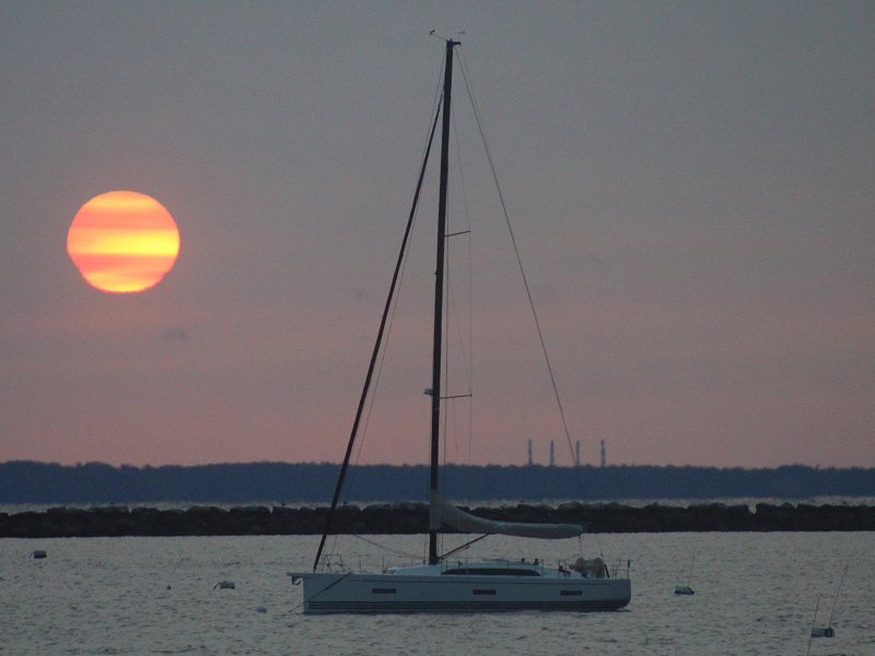
Not much snow in Long Beach, but it is Siberian approved.
-
11
-
-
2 minutes ago, jm1220 said:
How much on the ground there? Not surprised at all Long Beach would be one of the first places on LI to mix. Grew up knowing it.
Hard to tell. The wind is blowing what snow has fallen against my apartment. Maybe 2"? Also, we're back to all snow.
-
Currently there's sleet here in Long Beach, but some snow is trying to mix back in.
-
13 minutes ago, shadowsintherain said:
Cc radar? Link? Sorry.
.If you have a smartphone, I recommend downloading RadarScope.
-
Outside the metro, but if you like heavy snow and trains, this will be great cam to watch.
-
5
-
-
11 hours ago, bluewave said:
The models that handle the 500 mb heights near Oregon and general PNA best will get the storm track correct.
Bottom line: I'll be really curious to see tonight's MFR sounding. That 500mb height observation will perhaps help give us (and models) a clue where the storm might go later on. 5570m vs 5590m may seem small, but in a nonlinear system those tiny differences grow rapidly!
Following up this. Based on this post and the 0z MFR sounding, it would hint at a further NW track...
-
1
-
-
2 hours ago, donsutherland1 said:
Two photos of this morning’s smoky sunrise.
That's a crazy good shot! What an eerie world we're living in now.
-
3
-
-
Wow. These rainfall totals are unbelievable. I know it rained a lot last night but 4-5" is crazy. Thankfully not too much flooding in my part of Long Beach. The usual trouble spots are flooded but passable.
-
10 hours ago, Will - Rutgers said:
full disclosure: i was about to say "i don't see what you're seeing, i see the two TS and a lemon." before saying something stupid i decided to click around and discovered there's a 5 day NHC forecast graphical. been following weather my entire life, had literally no idea. don't think i ever saw it posted here.
alright now that we all agree i'm not mentally competent to stand trial, i have a question. does the NHC have any kind of follow-up post-season analysis of storm intensity predictions? probably not? i ask because it seems like storms have historically over-performed, but i have no data, just a WAG from hanging around here too much.
not looking to impinge the good work of the folks at the NHC, literally just curious. i recognize the amazing strides in weather prediction made in the last 20 years and i'm glad we have accurate tropical forecasting at all, especially with the added wild card of global warming.
Yes. Every branch of the NWS does forecast verification. Although, they're usually buried and can be hard to find.
https://www.nhc.noaa.gov/verification/
Also, I didn't know they did those forecasts either.
-
2
-

January 20-22 “bring the mojo” winter storm threat
in Southeastern States
Posted
weather.cod.edu