LakeEffectOH
-
Posts
299 -
Joined
-
Last visited
Content Type
Profiles
Blogs
Forums
American Weather
Media Demo
Store
Gallery
Everything posted by LakeEffectOH
-

Fall/Winter 2018-19 Complaint/Banter Thread
LakeEffectOH replied to IWXwx's topic in Lakes/Ohio Valley
Yeah, this past February's 500mb anomalies say otherwise...Nasty -PNA there!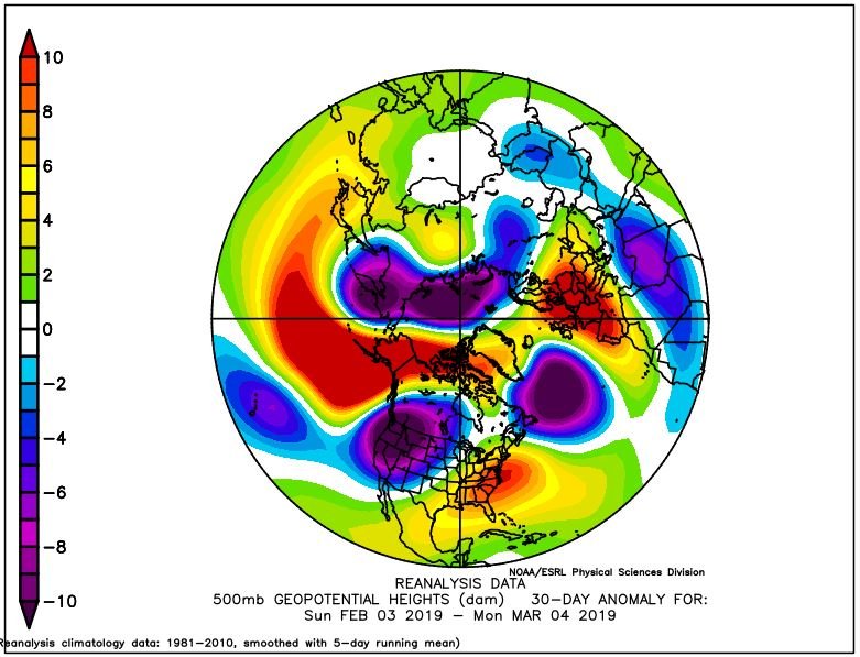
-
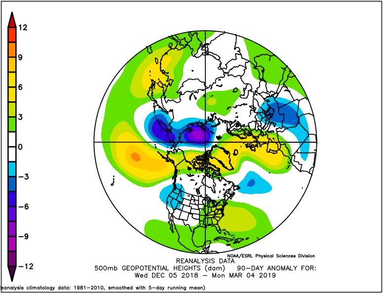
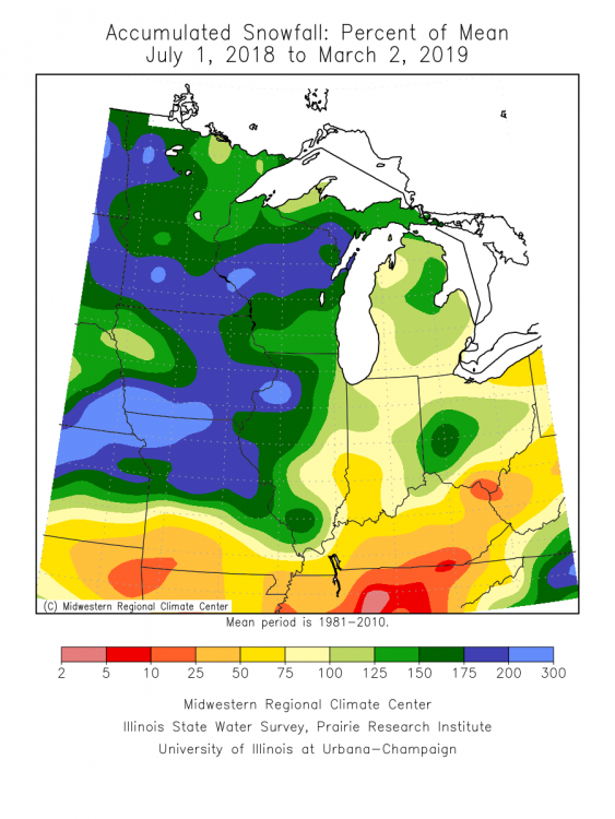
I checked BUF and was surprised to see they already have 113" as of yesterday. Must've been asleep, . -PNA pattern still messes things up as the beloved SE Ridge tilts the flow more ENE sending the LES away from us and to NWPA/WNY. Because of the -PNA's persistence, what few lake effect events we've had this year are brief, in and out events before the flow returns to the ENE. Eventually the SE Ridge is amplified by the next Cutter spiking our temps for 12-36 hours with a lot of rain to melt it all away. During Feb., the amped SE Ridge decided to camp out for much of the month. Also, a -PNA pattern sweeps high pressure into the area as we are in an upper level pattern dominated by flat ridging (SE Ridge), even when it is really cold, thus drying the air at all levels. During most winters, we get in at least a few upper level trough patterns that last several days and rotate little short waves once every 18-36 hours depositing a good bit of LES over much NE Ohio over the duration of said upper level trough. You can see the 500mb height anomalies for 2/3-3/4 and 12/5/18-3/4/19. The 2/3-3/4 heights are pretty telling.

-
I had 3" of fluff too. NWS CLE was forecasting their usual less than one inch accumulation. I hate that term less than one inch. The old little or no accumulation sounded better. When "less than one inch" or "less than 1/2 inch" is used, to me that has a rubbing your nose in it feel. End of rant...
-
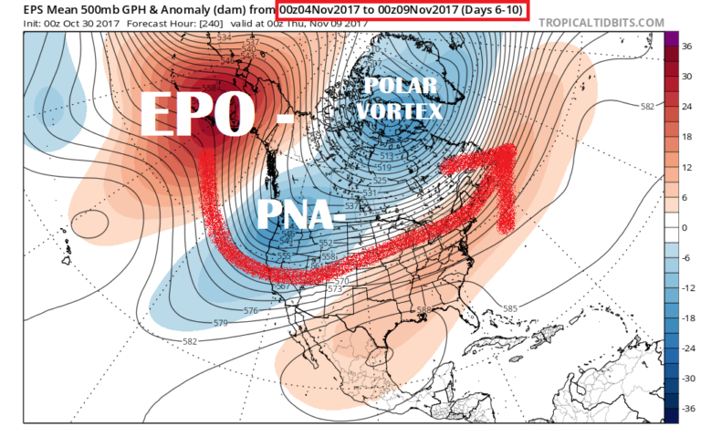
Plus the negative pacific north american pattern (-PNA )set up a mostly southwesterly flow that 1) Kept much of the snow well to the north and west of us (Congrats Minneapolis-St Paul) and shunted what little LES to our north an east. Even when temperatures are really cold, wind was out of the WSW. -PNA patterns often cause shear and sweep high pressure too fast for any decent LES, even in WNY. Good example of a -PNA pattern. From http://www.wisconsinwx.com.
-
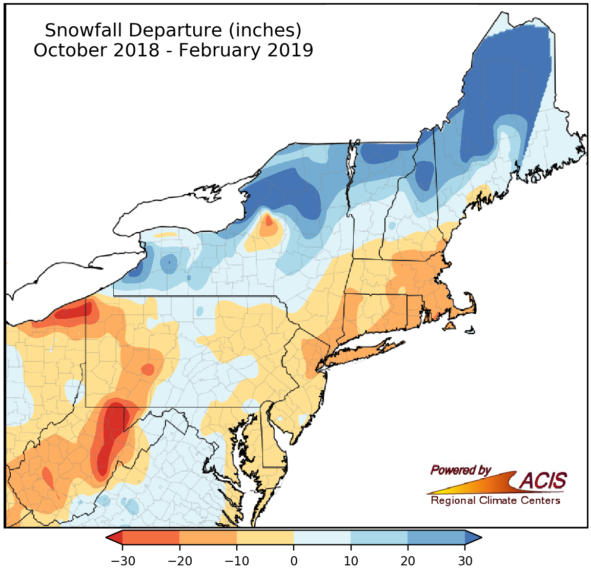
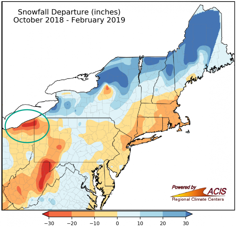
Seasonal Snowfall Departures Data/Maps
LakeEffectOH replied to Ralph Wiggum's topic in Weather Forecasting and Discussion
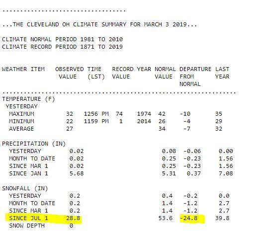
This year has been a disaster for the Cleveland, OH area. In fact, we've been below normal for eight of the past 10 winters...
-
Sad...Next winter HAS to be better...


-
Fall/Winter 2018-19 Complaint/Banter Thread
LakeEffectOH replied to IWXwx's topic in Lakes/Ohio Valley
If you live in the Cleveland, OH area...there's a LOT to complain about!


-
Looks like we had about 6" of paste in Chesterland. Down here at work in Solon...it looks more like 8" fell. Figures CLE issued an advisory with all the wind and snowfall. Late last night and this morning it looked more like warning conditions.
-
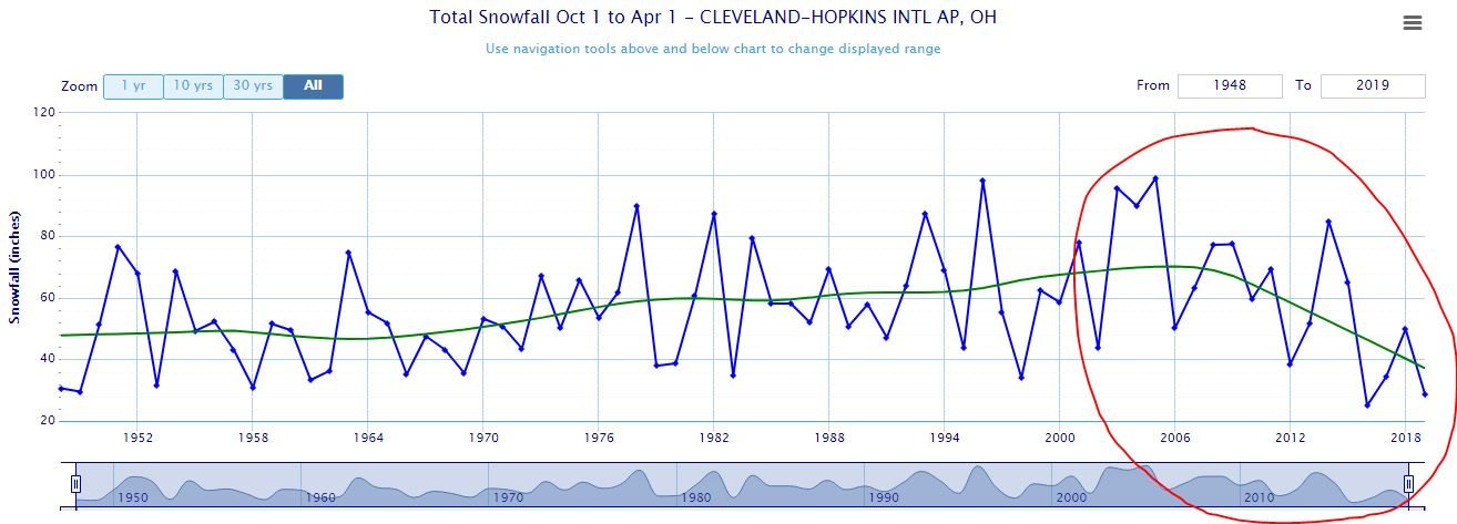
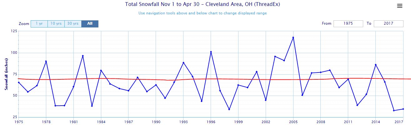
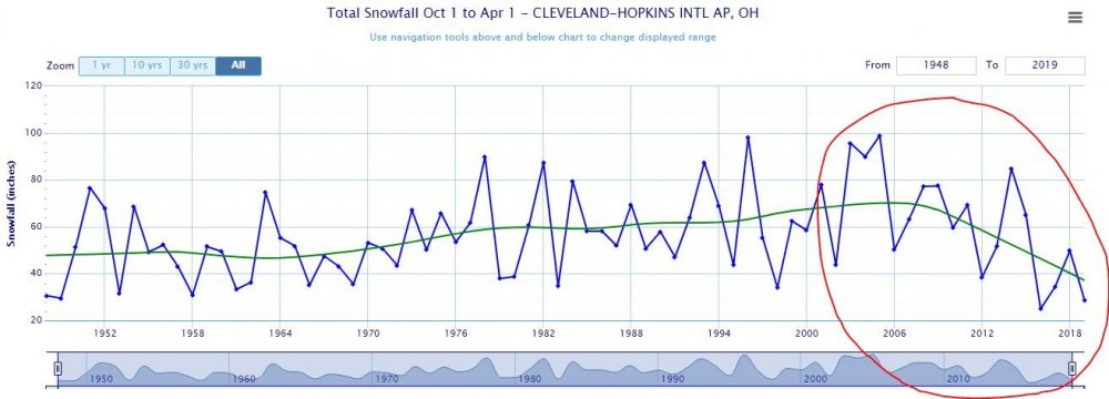
The 2010s are a far cry from the 2000s when big storms seemed to come once or twice a year. I remember the March 2008 storm well. 20-24" all the way up I-71.
-
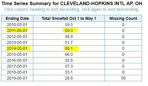
This has been a crappy snow drought...I don't think we've had a decent synoptic event (CLE having 10+") since early 2011. The GHD II storm in 2015 dumped over a foot in many parts of the area, but CLE picked up about 8". I attached a graph of annual snowfall totals for CLE. Red line is at 70" which is close to our annual average of 68.1" The 2010s have been below normal except for 2013-14.
-
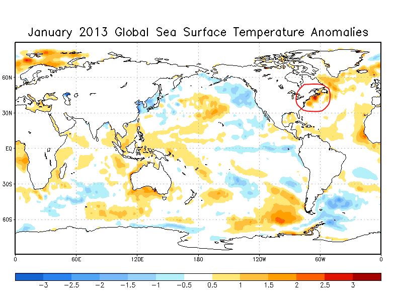
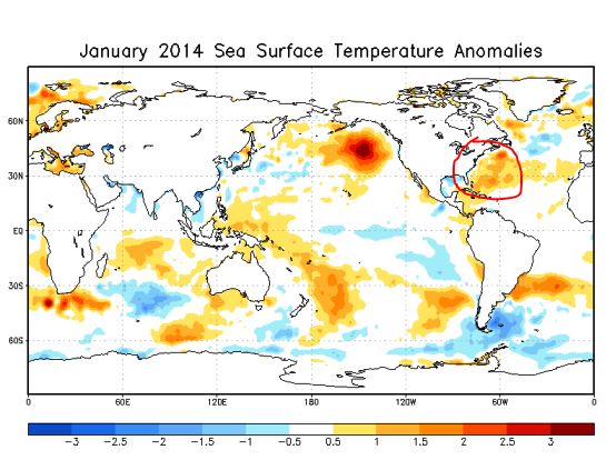
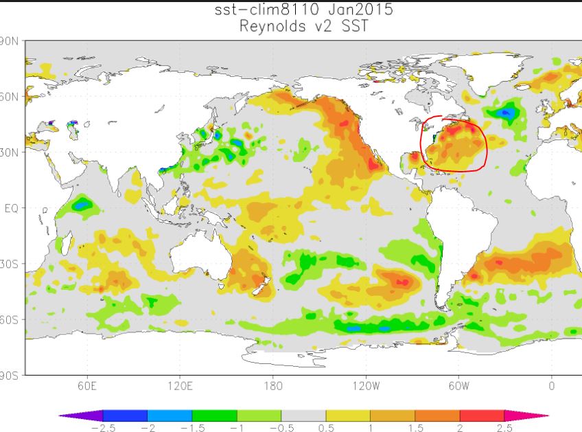
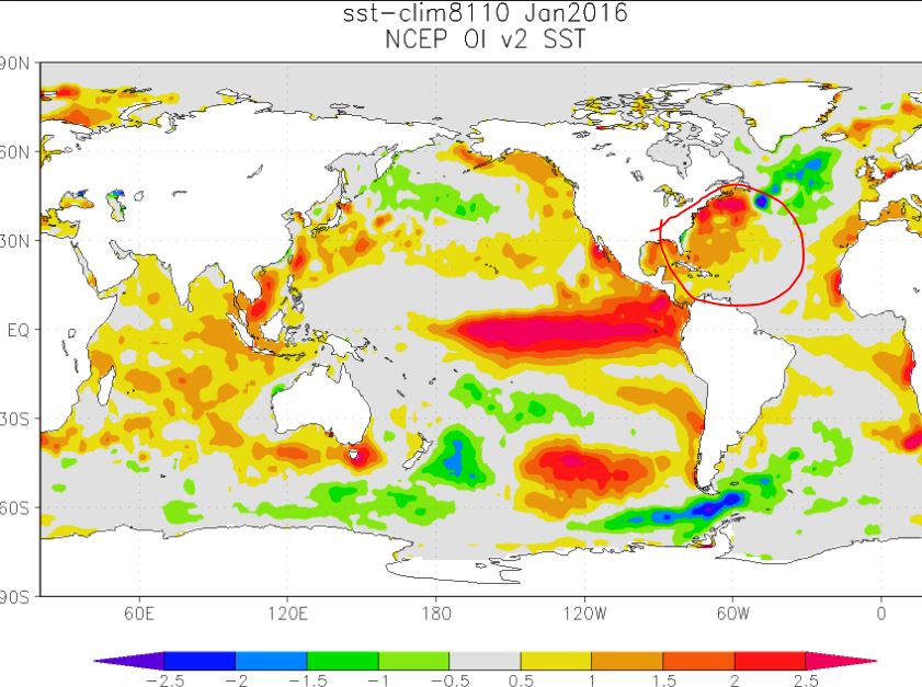
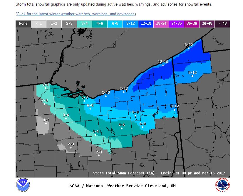
Hard to tell how much fell IMBY. My front yard has spots where the grass is poking thru, but my back yard has drifts up to 2 feet high. Judging by this storm total map from the NWS, Chesterland picked up from 8 to 10 inches. Overall, the storm under-performed based on the totals maps issued on Monday PM. I think, as often happens, drier air advected in faster than forecast, thus cutting snow totals...not to mention the primary storm getting its energy sucked out by the coastal.. It seems like coastals robbing primary storm systems as they approach NE Ohio have been fairly common over the past several years. This could very well be caused by persistent warmer than normal SSTs off the east coast. When the arctic air comes in from the west, clashing with the abnormally warm ssts, the coastal storms spin up fast and quite often, bomb out. SSTA Maps for recent Januarys...Notice the SSTAs off of the east coast (circled in red)...
-
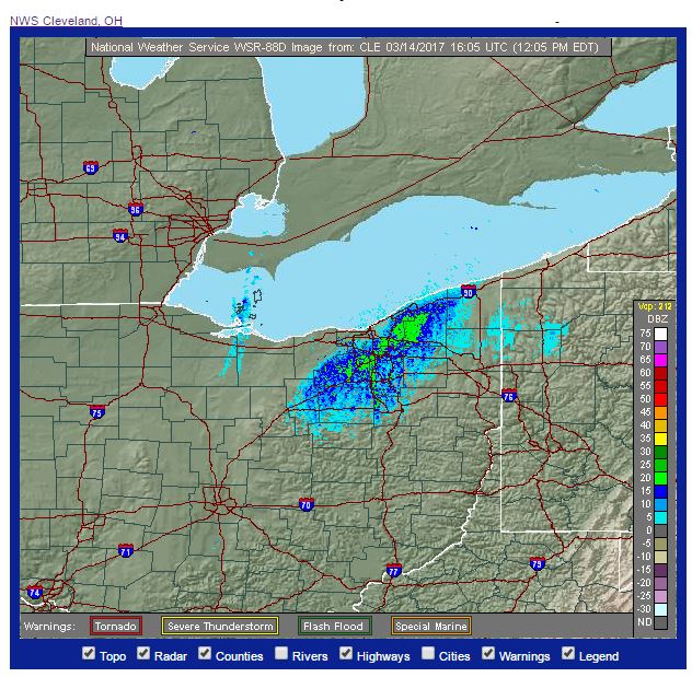
So far, Chesterland has been bracketed by the larger band about 5mi to our west and a weaker band just to the east. Only flurries over the last few hours w/no accumulation. Hope the situation changes.
-
The radar looks awful! Disorganized with Nothing but tiny popcorn snow showers scattered all over the place. Drive a half mile, you are in very light flurries. Go another half mile, its a whiteout. Ugh!
-
Looking out the window, I can actually see a slight blue tinge to the sky overhead.
-
Hopefully it will be over Cuyahoga, Lake & Geauga by tonight. If so, we should have some decent accumulations as there is no sun to fight!
-
Seems that the clouds are pretty thin too. I remember Dick Goddard saying that LES clouds were normally pretty thin.
-
Radar shows most of West Geauga getting pounded
-
Earlier this AM in Chesterland, there were almost bare places with grass showing with other places over 6" deep. Wind, of course... My WAG is around 3" as of 8 am. Been snowing pretty hard in Solon. Interesting with the higher sun angle, it looks as if the sun is trying to come out. Again, hard to say how much has fallen because of the wind and probably, a stronger sun evaporating (not melting) some of that snow since the moisture content is low.
-
CLE has expanded the 12-18" storm totals. Last night, the shading was for northern Geauga county & Erie county PA. Earlier today, the western edge of the 12-18 just touched the Cuyahoga/Geauga line, but covered the Primary belt east into PA. Now...
-
Local QPFs from the 18Z 12KM & the 18Z 4KM NAM look a little better than the 12Z runs.
-
Count me in! Haven't posted this year any. Lots of stuff going on, but meeting up is a great idea!
-
Chesterland had around 13-15" since it all started on Monday. Snow depth has settled to around 8". We will be slammed by next week's storm. How do I know? Because I'll be in California all next week.
-
Radar looks kind of meh now with popcorn snow showers.
-
That band looks pretty intense...Picked up about 5" last night. Have around 6" on the ground. Probably a total of 8" so far with 2 of those inches lost to compression.
-
OHWx...seriously, I think you are one of the best posters on this site. I always look forward to what you have to say about upcoming winter events! Many thanks!!