

Hurricane Agnes
-
Posts
8,575 -
Joined
Content Type
Profiles
Blogs
Forums
American Weather
Media Demo
Store
Gallery
Posts posted by Hurricane Agnes
-
-
Had jury duty today (got caught and am a juror) and when I went out the door to head on downtown, I saw RedSky...errr... a RED SKY.
 And I mean RED. I see there are storms galore to the south right now.
It made it up to 82 IMBY (much higher downtown - my car thermometer kept reading like 86 on my way home today).
Currently partly sunny and 79 with dp 55. Turned the ole house AC on for the first time this season. I know that Aprils sometimes have these hot spells around this time so not unexpected.
-
That line "looked good on radar" but seemed to have fizzled by the time it got here after 9 pm. Deposited 0.06" in the bucket and some kind of pop-up happened after midnight for an additional 0.05" (total 0.11" for the 2 days). It did drop the temp almost 10 degrees when it came through.
Had a low of 40 yesterday and made it up to 74 for a high. Looks like it'll get fairly warm today.
Currently 60 with dp 55.
-
Sun has mostly popped out and finished up this round at 0.62" in the bucket (0.68" 2-day total). Ended up bottoming out at 55 and it's currently 62 with dp 52.
-
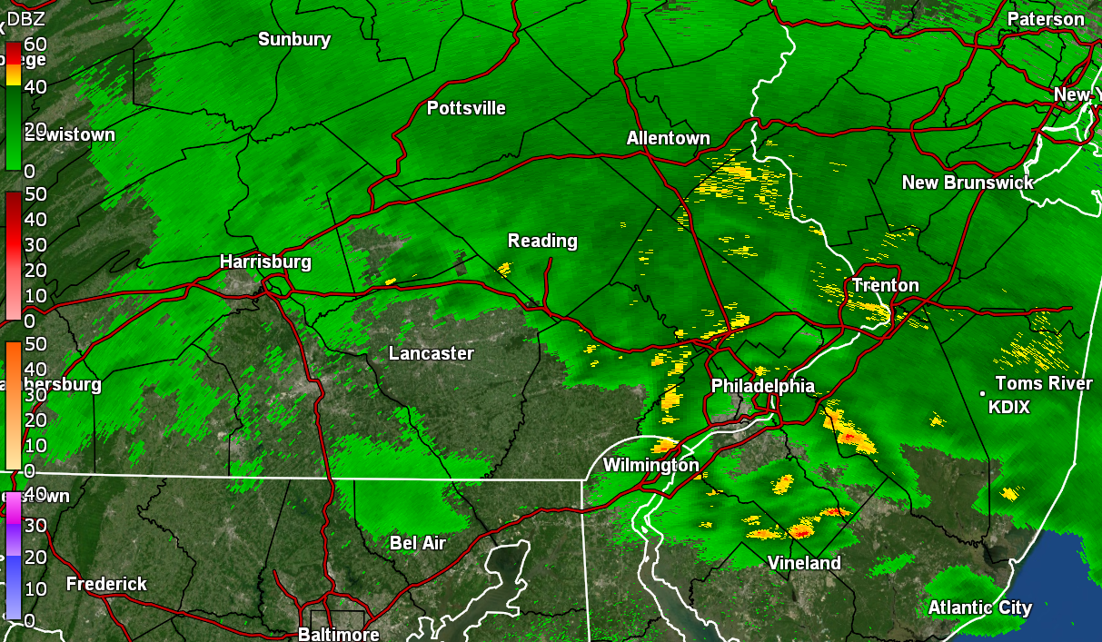
Under one of those segments and getting a gully washer here with >1"/hr rates and some good wind gusts. Had on and off rain overnight and currently have 0.51" in the bucket (with 0.06" yesterday have a 2-day total of 0.57:).
High/low the past couple days were 74/53 & 74/52 and it's been humid those couple days.
Currently at my low for the day of 59 with heavy rain and dp 58.
-
After a 44 low, I actually made it up to 78 for a high!
Had been watching a sea breeze front move inland until it hit the Delaware River and dissipated. It did bring in some more clouds as it approached though.
Currently 69 with dp 49,
-
On 4/6/2024 at 3:32 PM, RedSky said:
So far several Chinook copters passed overhead with military staging in the Lehigh Valley.
I heard them on and off all weekend and finally heard something on KYW about a mix of helicopter activity that was scheduled over the weekend and today. Tried to jump up to catch them but they were gone by the time I would get outside. I know I used to see them when Willow Grove Naval Air Station (later renamed as a Joint Reserve Base) was active. Plus whenever there are celebratory flyovers down in South Philly over the stadiums, they zoom back and forth over this area.
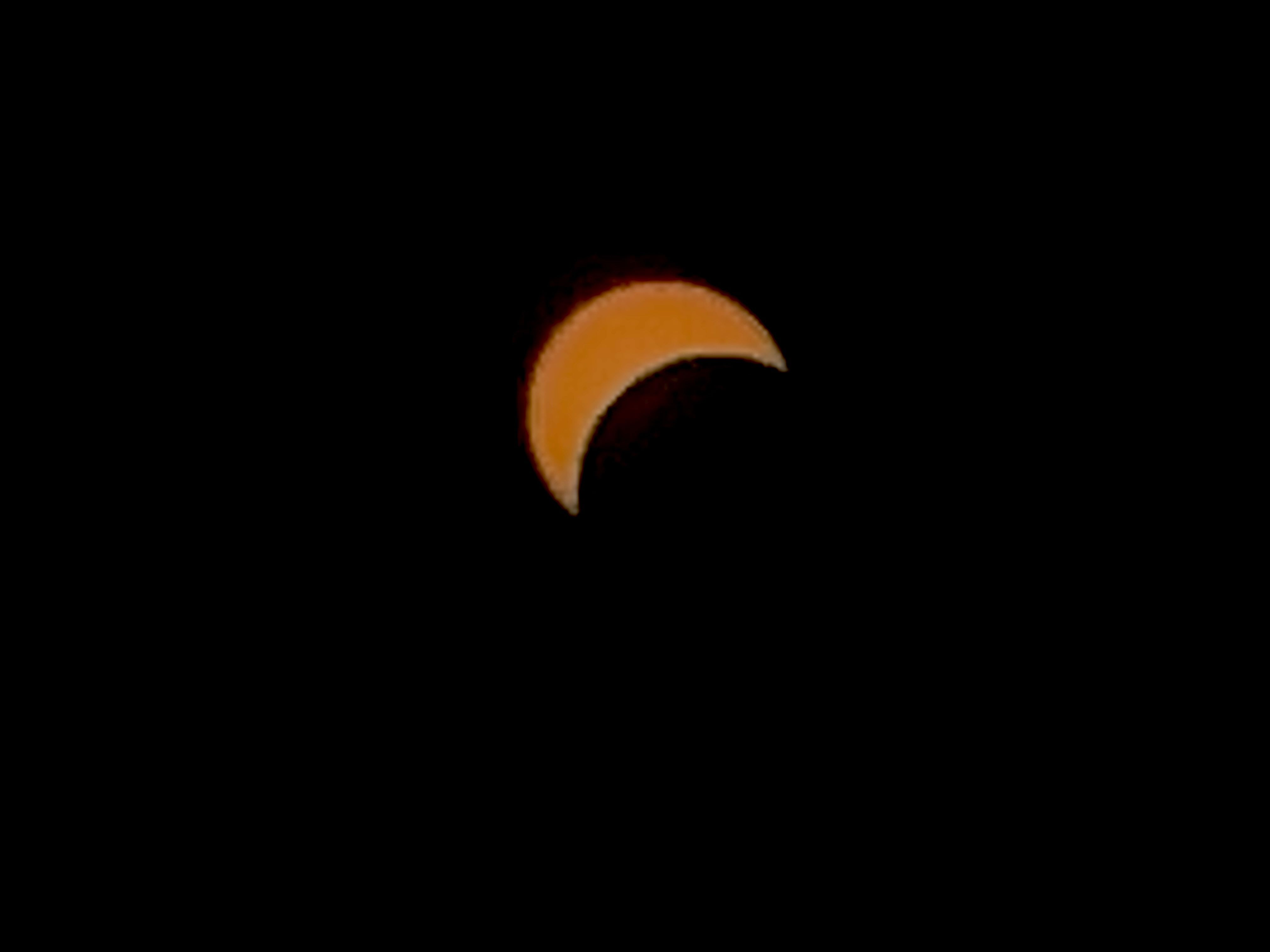
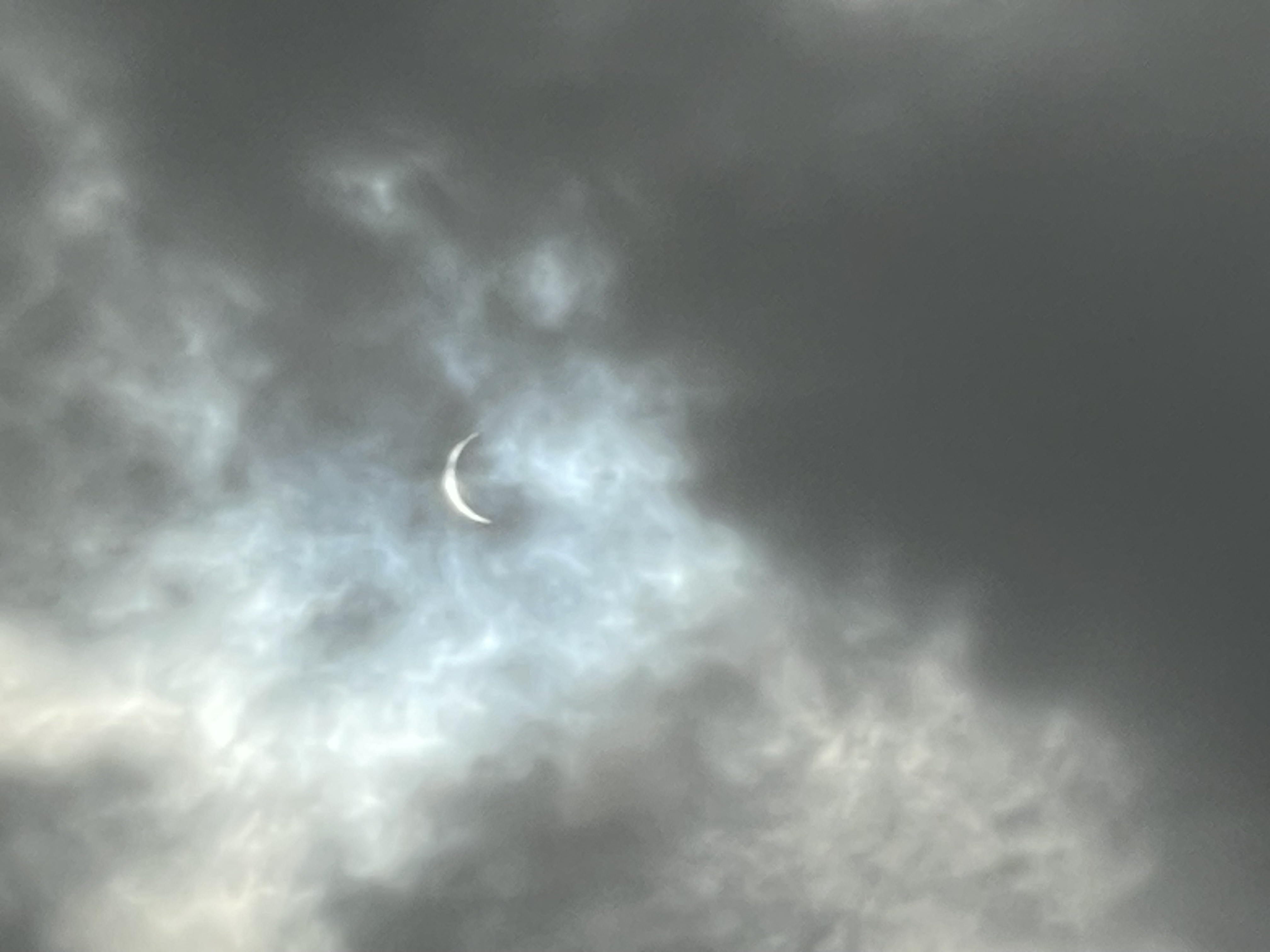
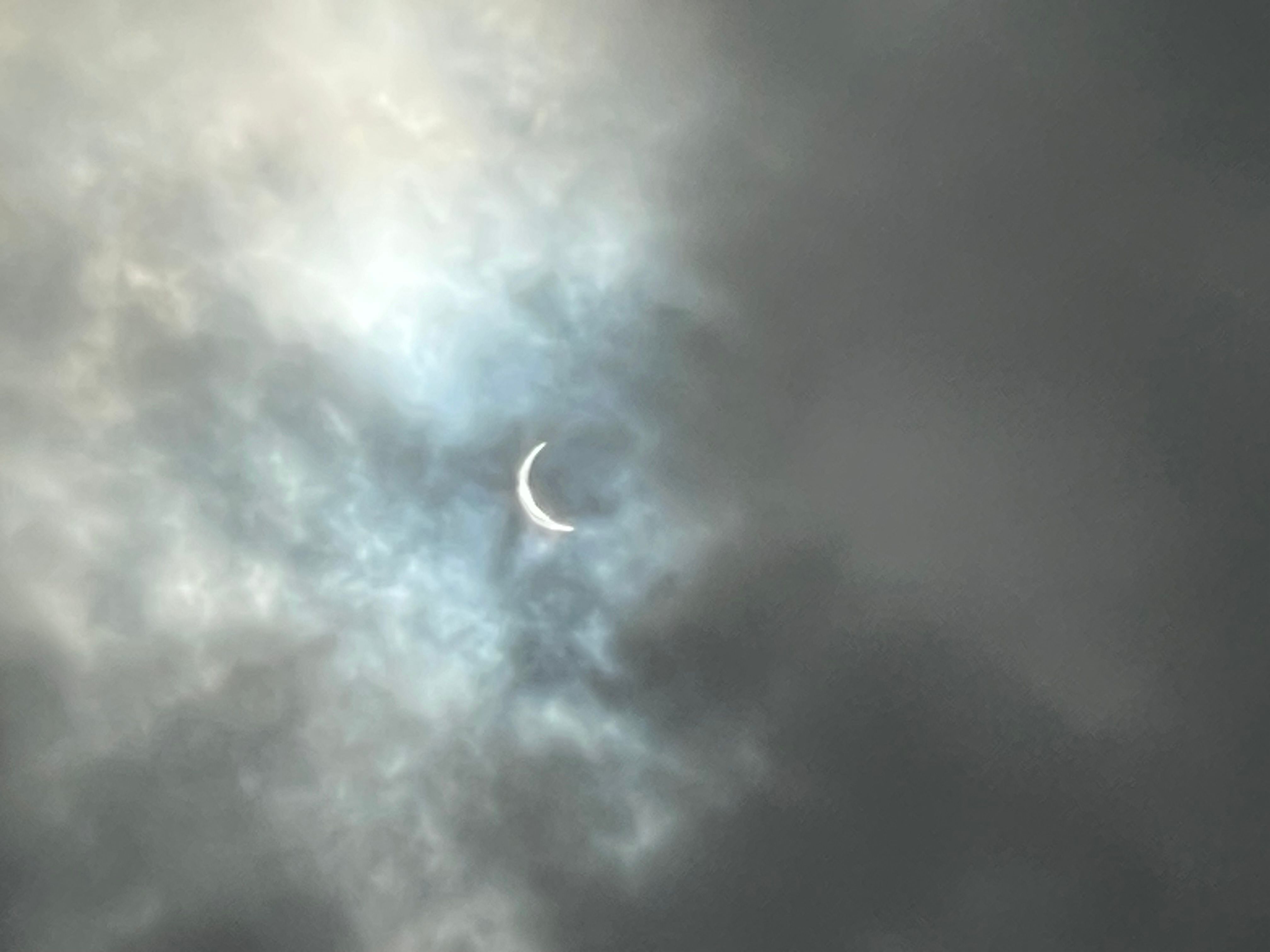
2 hours ago, Birds~69 said:Think 3:23pm was peak. Or was it start? If so, no way that was 90%...
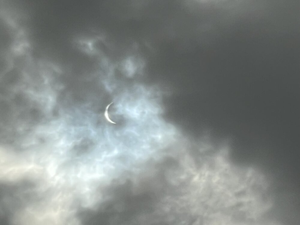
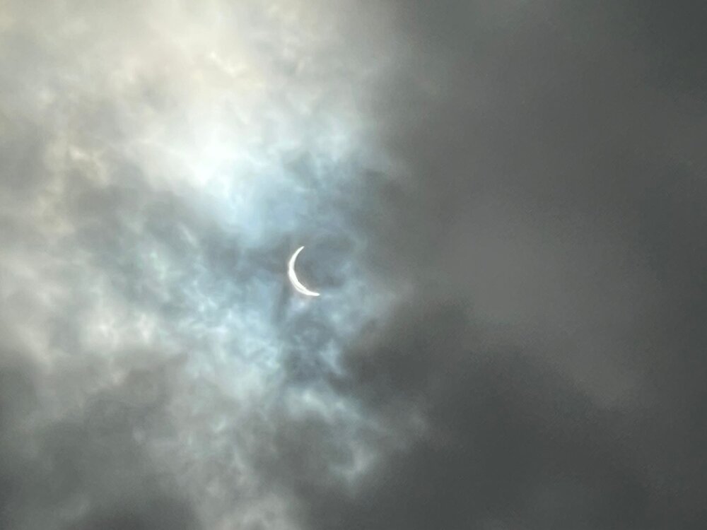
I was at my sister's house in her front yard during the event and a nice dark cloud literally sat over the sun right at 3:23 but I caught some pics at 3:22 pm and 3:.24 pm (plus an earlier one using an app taken at 2:59 pm).
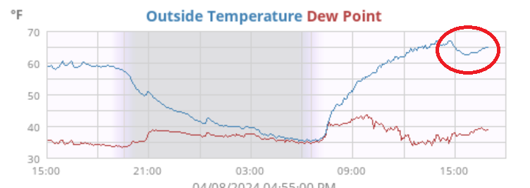
Also did a snapshot of the temps (circled) during that the eclipse time frame and you see the drop.
I had bottomed out at 35 this morning but made it up to 68 about 30 minutes after the eclipse had started (at 2:35 pm). All in all, it was a nice day with a little breeze that kicked in.
Currently 64 with dp 40.

-
 4
4
-
-
12 hours ago, RedSky said:
There was a 4 aftershock an hour ago, didn't feel it
Didn't feel that one either. There was a 2.5 at 6:46 this morning but I thought I felt something at 6:52.
Ended up hitting 51 for a high yesterday after a 39 morning low. Low this morning has also been 39 and it's currently partly sunny and 44 with dp 35.
-
-
Just now, LVblizzard said:
Uh…was there just an earthquake? Anyone else feel that?
YES!! Started around 10:23 and ended around 10:24 !!! Maybe about 20 seconds.
-
9 hours ago, KamuSnow said:
I've got sunshine, on a cloudy day....
Now I'll have that song as an earworm the rest of the evening!
Had a brief warm-up where I managed to hit 54 for a high just after 2 pm. I also got a brief shower to give me another 0.01" for 0.25" for the day (so far) and 3.08" over the 3 days. There's an incoming cluster of something so that might add to the total later tonight.
Currently 44 with dp 41.
-
Got an additional 0.22" last night to finish up with 1.75" for yesterday. And with another 0.24" earlier this morning, I so far have 3.07" for a 3-day event total.
There is an odd yellow orb in the sky this morning, and after bottoming out at 38, it's currently partly sunny
 and 39 with dp 39.
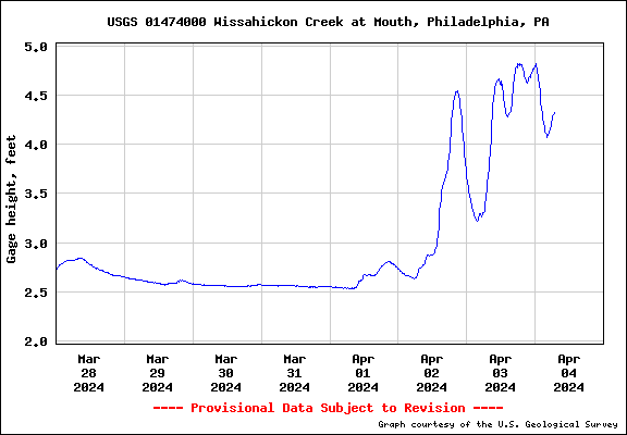
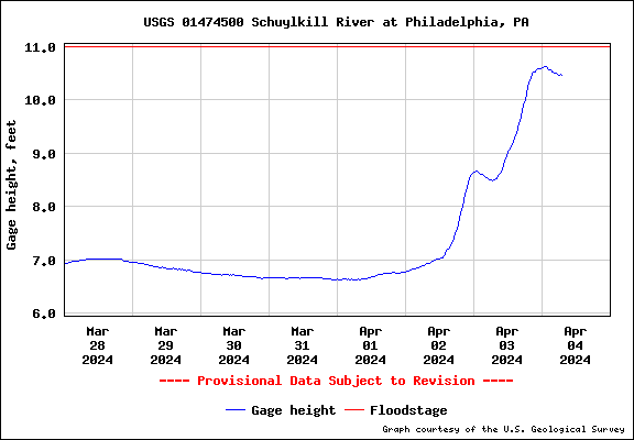
ETA - So far have 3.75" of rain for the month and the Wissahickon creek is pretty much lapping the banks and the Schuylkill @ PHL just barely missed flood stage (so far) but might still get there if the rain picks up again.
-
1 hour ago, RedSky said:
Winds are roaring once again
They sure have for the past couple hours.
Currently in a rain lull again after a long round 2. Picked up an additional 0.28" giving me 1.53" for the day (2.61" 2-day total). My high ended up being 44 at midnight.
Currently a windy and misty 42 with dp 42, and low stratus.
-
Looks like a Tornado Watch is up for the southern part of the CWA (Delaware) -
QuoteTornado Watch
TORNADO WATCH OUTLINE UPDATE FOR WT 87
NWS STORM PREDICTION CENTER NORMAN OK
1235 PM EDT WED APR 3 2024

TORNADO WATCH 87 IS IN EFFECT UNTIL 700 PM EDT FOR THE
 FOLLOWING LOCATIONS

DEC001-005-032300-
/O.NEW.KWNS.TO.A.0087.240403T1635Z-240403T2300Z/

DE
.    DELAWARE COUNTIES INCLUDED ARE

KENT                 SUSSEX
$$
-
1
-
-
Just had a rolling thunder. Definitely audible although not directly near but a bit distant.
ETA - getting a thunderstorm now. Heavier rain and more persistent thunder.
-
2
-
-
Since this morning, I have picked up another 0.70" of rain for 1.25" for the day so far and heard my first thunder (albeit soft) about 5 minutes ago. Total so far for the 2-day event is 2.33".
Currently getting light rain and temp is down to 42 with dp 42.
-
1
-
-
Am in a little rain lull at the moment with the finishing up of a round 1 that added an additional 0.20" to the tally since my last post, for a total of 0.50" at post time (1.62" 2-day). Temp has dropped down to 43 with dp 43 and it is currently overcast, breezy, and misty.
-
1
-
-
My lightning detector has been firing between 2 am and now as a little disturbance comes through. Haven't personally seen the lightning and haven't heard any thunder but something is going on!
Finished up with 1.30" of rain yesterday and currently have 0.30" this morning for a 2-day total so far of 1.60". Currently light rain and 44 with dp 43. Had been using KDOX when KDIX was flakey.
-
1
-
-
Temp has stayed pretty steady much of the day and round 3 gave me another 0.60" for a total of 1.23" for the day so far. Round 4 looks to be out in western PA, probably due here overnight and into tomorrow, triggering formation of a nor'easter at some point.
Currently in a rain lull but it's misty and 45, with dp 45.
-
Bottomed out at 45 this morning (with a high so far at midnight of 48). Have had 2 rounds of rain today so far - 0.47" for the first round and an additional 0.16" in round 2 for a total of 0.63" at this current lull. Another round is incoming and should be measurable shortly.
Currently an overcast and misty 45 with dp 44.
-
Ended up with 0.11" of rain on Saturday, with a high/low of 59/44 yesterday. Finished up March with 8.83" of rain.
This morning's low was 47, and it's currently 48 with dp 47 and light rain. So far have 0.33" in the bucket. Measurable rain didn't start until about 7 am IMBY.
11 hours ago, Birds~69 said:Phils will be dodging raindrops w/a 3 game series starting Monday at CBP.
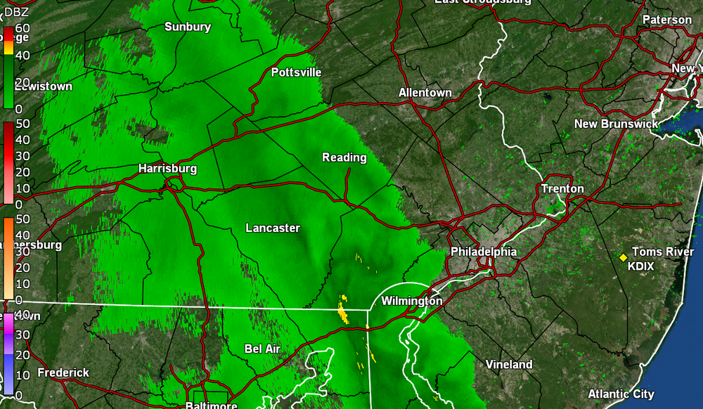
Franklin Institute: (Weather looks pretty good)
On Monday, April 8, beginning at 2:08 pm, a solar eclipse will be visible across America. Because here in Philadelphia, we are off the path of totality, we’ll see a partial eclipse, the first in this region since August 21, 2017. Around Philadelphia, the moon will cover
90% of the sun.
46F/Cloudy...rain looks just W of PSU.Crossing fingers that holds because all of the media hype since last December, kept blanking this area out for viewing based on historical trends (although we do often miss nighttime phenomena due to weather no matter what time of year
 ).
).
Hell... "90%" is more than what we got in 2017 and 2017 was pretty cool in any case!
-
2
-
-
16 minutes ago, KamuSnow said:
Getting some light rain here, refreshing while raking sweet gum balls, lol.
Some of it is over me now but getting virga at the moment although the dp is still going up so I guess trying to moisten things up enough to rain. What might be a heavier band is still to the west. Down to 57 with dp 35.
-
1
-
-
Ended up with 0.49" of rain in the bucket on Wed. and finished up with 0.10" on Thurs. for a 2-day total of 0.59".
Made it up to 55 for a high yesterday after a 39 low, and touched 60 today after a 38 low.
It has clouded over now as some rain is approaching, and temp is 58 with dp that has crept up to 33.
-
On 3/25/2024 at 1:17 PM, JTA66 said:
And the opener was postponed.
And I remember a certain World Series game years ago when the rain was just coming down like crazy.
Well I was able to get out early this afternoon, take care of an appointment, get air in one of my tires, and get home just as it started spritzing. Getting heavier showers now.
Past couple days of highs/lows were 52/32 & 58/36. This morning's low was a milder 42 and made it up to 49 before the rain started. Currently 46 with light rain, dp 44, and 0.09" in the bucket at post time.
-
And the winds have arrived here. Literally has the house creaking and groaning.
Temp down to 36 with dp 30.


E PA/NJ/DE Spring 2024 OBS/Discussion
in Philadelphia Region
Posted
Ended up hitting a high of 82 on Monday after a 59 low, and then had a step down to 72 for a high on Tuesday after a low of 48. Today ended up being an even cooler 67 for a high after a similar low of 48 this morning.
Round 1 of rain gave me 0.20" before exiting but I did get a few hours of sun and cirrus this morning before it clouded over and started to rain just before 1 pm today.
Currently have an overcast sky and a temp of 60 with dp 56.