

StruThiO
-
Posts
82 -
Joined
-
Last visited
Content Type
Profiles
Blogs
Forums
American Weather
Media Demo
Store
Gallery
Posts posted by StruThiO
-
-
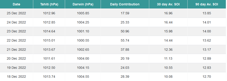
I'm sure some kind of Darwin low had to have skewed this, but nonetheless, I've never seen daily SOI values of +50
-
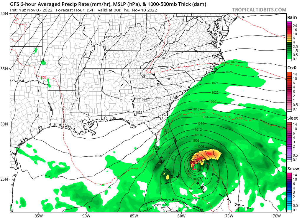
All I gotta say is. I hope people are taking this one seriously despite the calendar

-
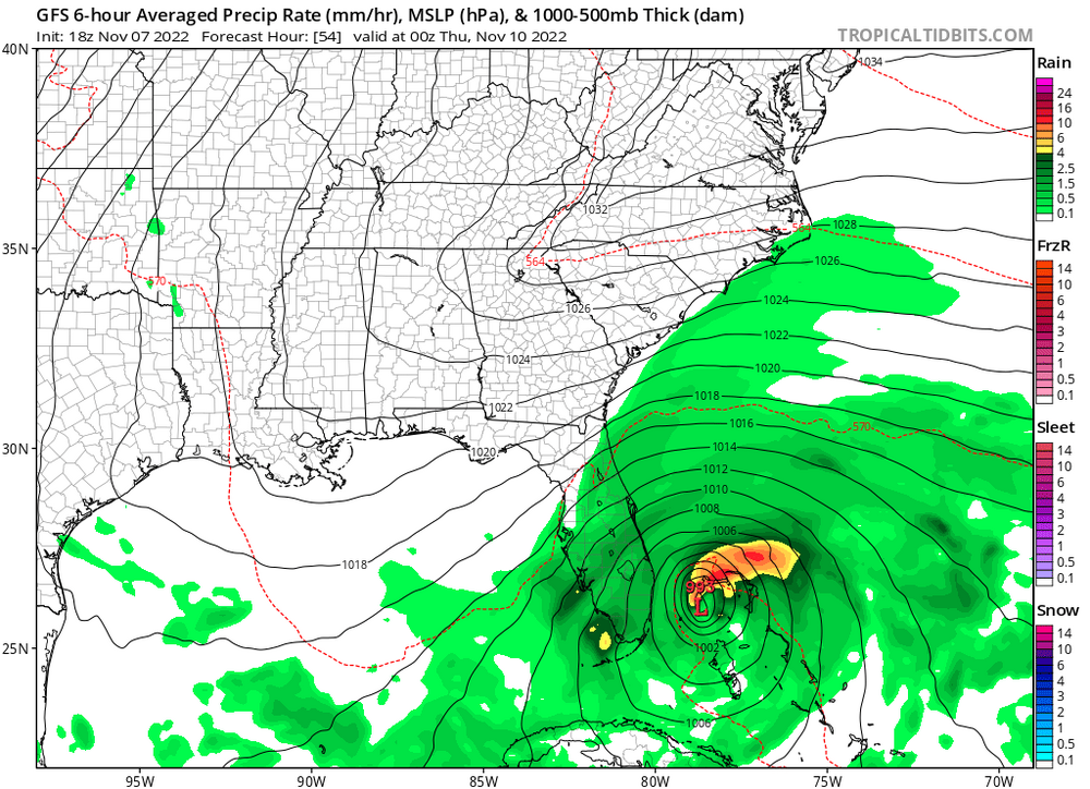
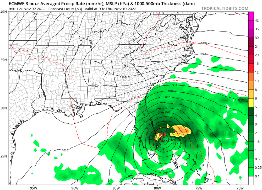
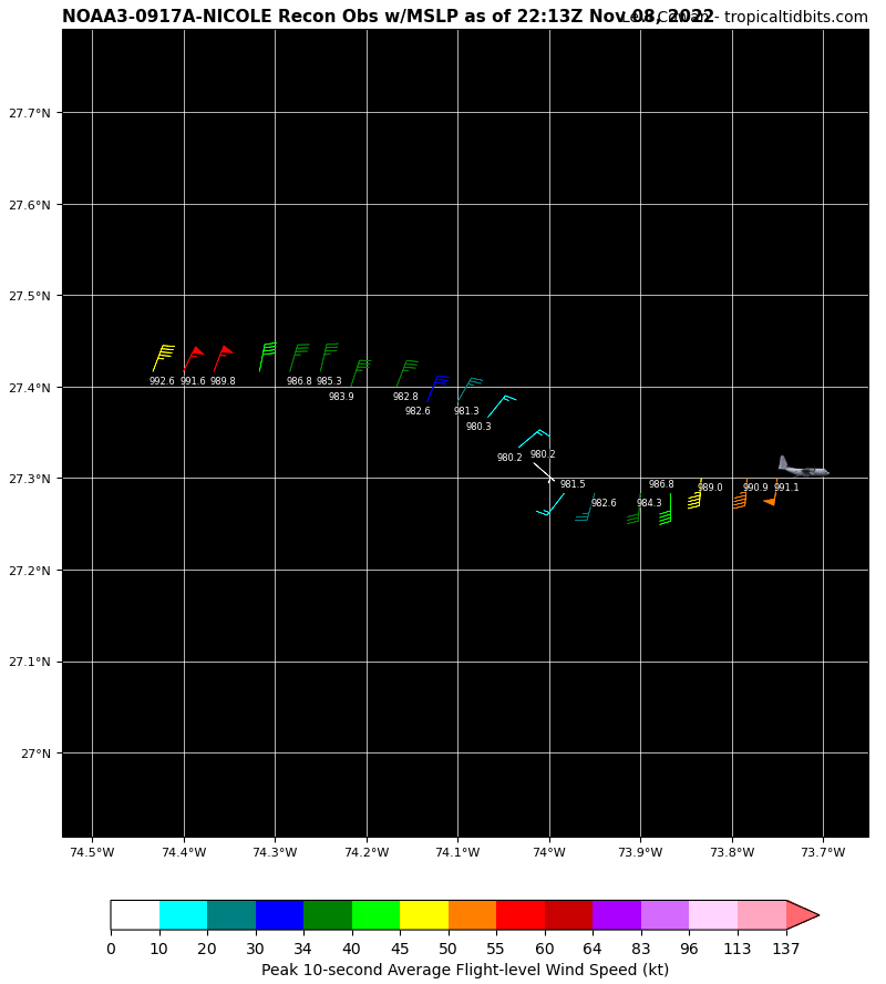
Here's how Nicole's current pressure of ~993-4mb (per 995mb dropsonde w/ 29 kt surface wind) compares to global guidance from two runs ago near landfall:
BTW, once this becomes a hurricane this season will have had more hurricanes form just in November than during all of 2013. As usual, that analog never holds any serious weight to it. RIP downcasters and bears
-
54 minutes ago, Akeem the African Dream said:
looks awful
like a typical November gale
Denial is the first stage
-
 2
2
-
 2
2
-
-
On 10/9/2022 at 6:16 PM, Amped said:
Nothing in the foreseeable future.
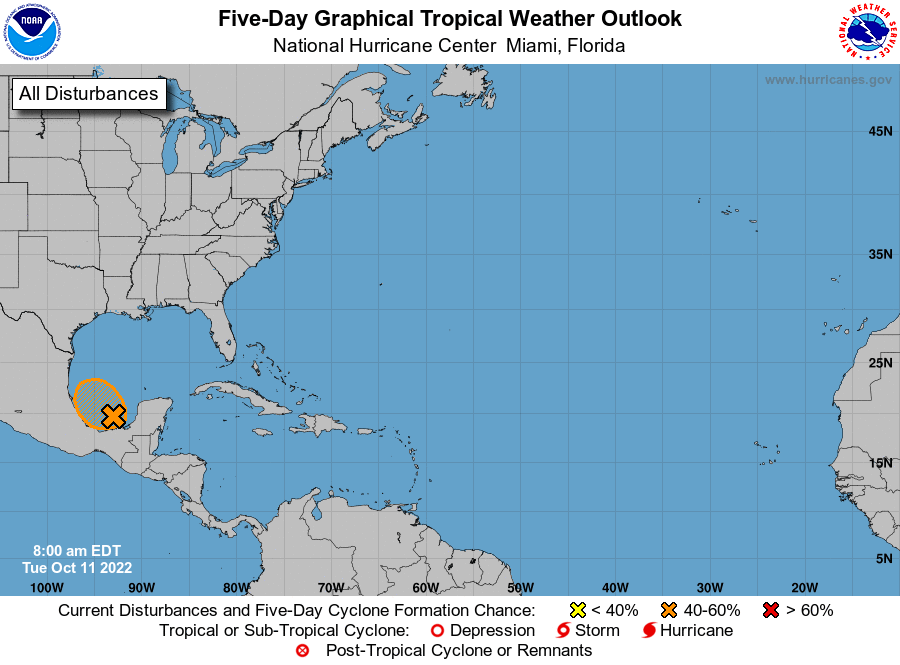
Took 36 hours for a 60% chance of development for now 93L
On 10/9/2022 at 1:41 PM, GaWx said:Make that two now, Fiona and Ian.
Julia has killed at least 60 people, I wonder if that makes it three. Not bad for another 2013 :rollseyes:
-
Here's a link to a real loop (ie, more than five frames):
-
Ridiculously small file size limit of 1.95mb means I can't post an actual loop
.thumb.gif.a715da77210b72b58d2ed90ebf5c9746.gif)
-
1 hour ago, tiger_deF said:
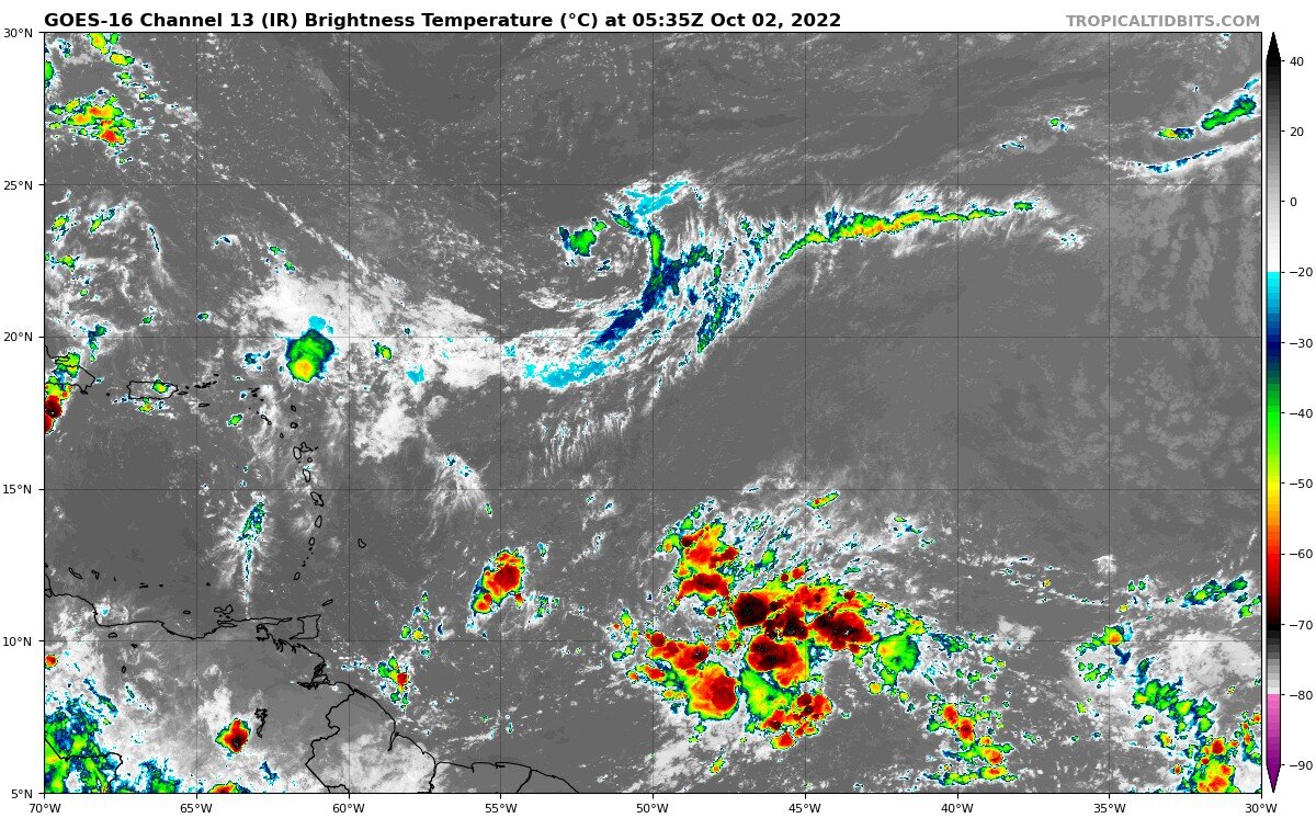
In the past day this wave has blossomed into one of the better looking ones this season, with lots of convection, a relatively moist environment, and growing vorticity. Early October can often signal an end to threats from the deep tropical Atlantic, but the delayed nature of this season could mean a later end to CV season as well.
The UL to the left will provide some short-term barriers to intensification, but I would not be surprised to see a tropical system developing before it reaches the Caribbean.
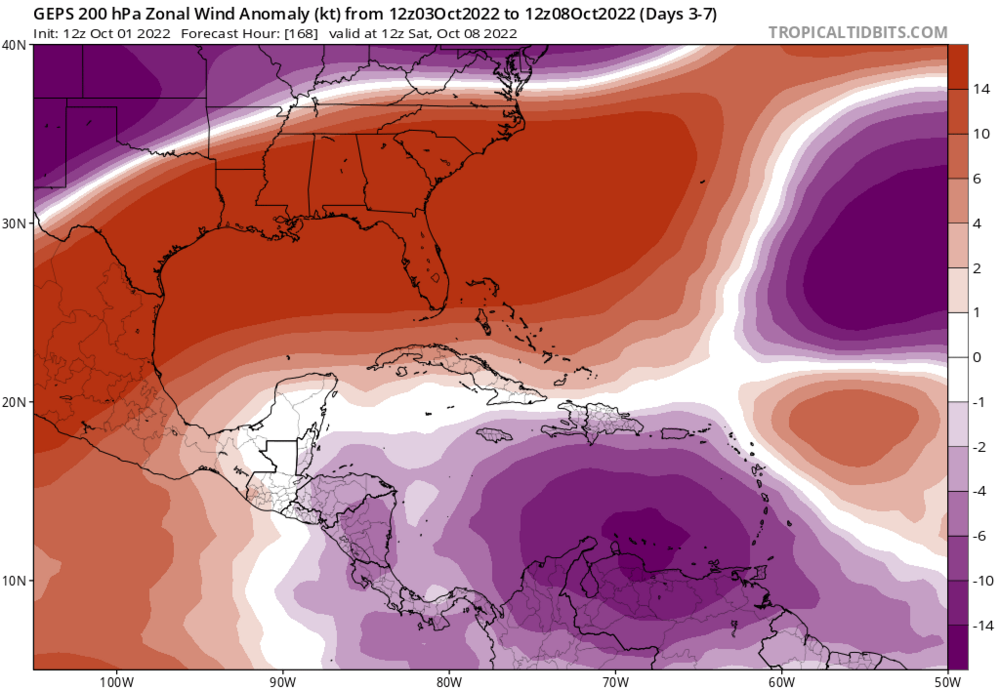
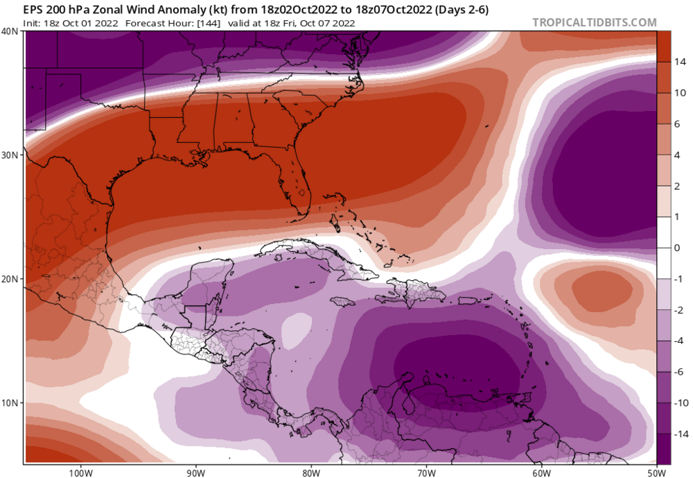
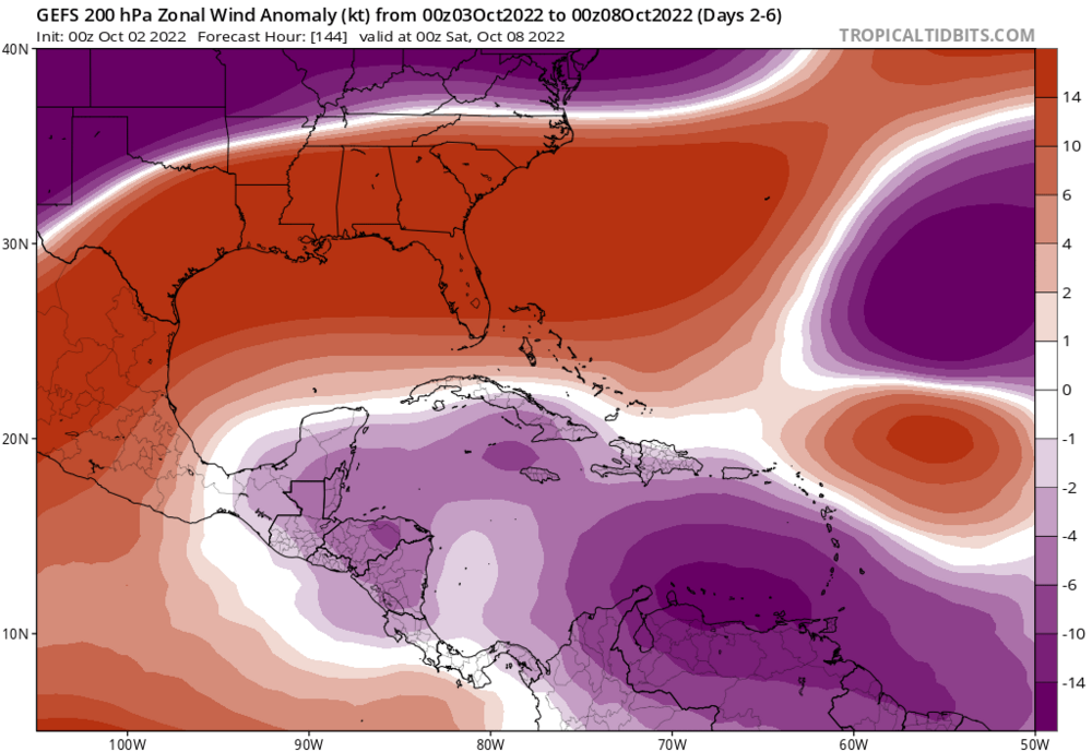
No idea why people aren't discussing this. Globals unanimously depict favorable anomalously easterly upper flow over the Caribbean, consistent with La Nina. This looks like trouble to me.
-
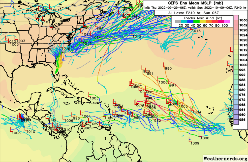
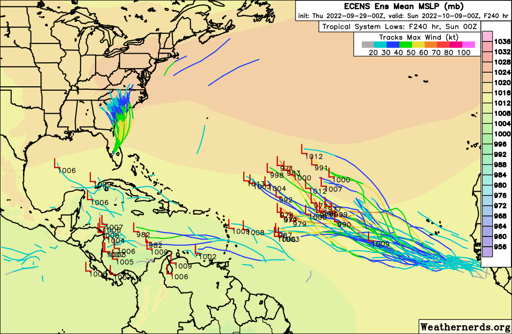
GEFS trend. Becoming uncomfortable very quickly
-
Do NOT like the trend between yesterdays 0z EPS and todays 12z
Appears to be associated with the tropical wave along 40W.
QuoteA central Atlantic tropical wave extends along 38W, from 04N to 19N, moving W at 10 kt. Scattered moderate convection is observed from 06N to 13N, between 35W and 43W. A recent scatterometer pass found moderate to fresh winds shifting from E to NE across the wave axis.
-
-
6z GEFS; 0z EPS.

-
On 9/27/2022 at 12:21 PM, Tallis Rockwell said:
Everyone was predicting another hyperactive system which we are still not seeing, 1 or 2 major landfalls doesn't mean the season is active. Let's say that there are only 4 hurricanes for a season but that all make landfalls, does it sudden;y make the season active? Of course not. An impactful season doesn't have to be an active season.
ACE is ALREADY NEAR-NORMAL.
On 9/27/2022 at 2:02 PM, Tallis Rockwell said:we're not going to break average numbers
WE ALREADY DID
-
10 hours ago, Prospero said:
Whatever. The Legend is Charlie was a Cat 5 badass legendary storm that is known as the most mighty badass legendary Cat 5 to ever hit these parts in a long time.
Don't mess with me on banter. Charlie was a Cat 5 for the Legend.
Maybe the Cat 5 legend was born when the hype was all about rapid intensification over favorable conditions on its way to destroy Tampa Bay. Was there a Cat 5 model coming over the Sunshine Skyway Bridge over Tampa Bay?
CHARLEY. CHARLEY. CHARLEY. IT'S SPELLED CHARLEY.
-
1
-
1
-
-
Up to two high-impact sure-to-be-retired major hurricanes before October with an entrenched La Nina. Wheres the 2013peat bustcasters now? I demand a refund
-
1
-
-
57 minutes ago, CheeselandSkies said:
It's a Cat. 1. It's not a secret that Cat. 1s, even T.S.'s (heck, even open waves) are capable of catastrophic freshwater flooding, usually due to some combination of meteorological and geographic/orographic factors as is the case here.
However, its existence does not "un-bust" pre/early-season forecasts of AA to hyperactive ACE totals and multiple long-tracking CV majors.
No MDR season this year!
-
1
-
-
On 9/9/2022 at 5:04 AM, NorthHillsWx said:
Guidance has, um, apparently forgotten it’s hurricane season. Takeaways:
1. EC trough will continue to offer protection from anything that forms from the east
2. No MDR season this year. Rinse. Wash. Repeat. Wave breaking continues and it seems guidance has picked up on the hostile conditions.
3. TUTT will continue to hinder development from eastern Caribbean through the middle of the basin
4. Some hints at a more active western Caribbean though few members are showing actual development. I’m really thinking our only threats this year will originate here.
Ensemble guidance 3 or 4 days ago, especially EPS, really looked like the proverbial switch had flipped as most members developed 95L, the current lemon, and the following wave. No more. We’re back to the doldrums in peak season. I have officially declared MDR dead. Thinking our season shifts with climo to western Caribbean and GOM but will be slow for next 10 days. We’ve probably surpassed 2013 bc of Earl, but at this point it may be a stretch to get double digit NS numbers. Never count out late September and October in the aforementioned areas though. It only takes one. I just don’t see it yet on any of the guidance this morning
On 9/8/2022 at 6:10 AM, StantonParkHoya said:This is analogous to the snow weenies annual "we can get good storms in March and April"....
On 9/12/2022 at 4:00 AM, A-L-E-K said:what a bust of a season
do better, weenies.
-
You know how they say it only takes one for a memorable / destructive season?
Looks like we found our one. Fiona is a retirement guarantee
-
Down goes 2013 as we have tied its hurricane total today, the 6th of September. Not that it was ever a real analogue in the first place
-
Danielle set to become stronger than any system during 2013 and will contribute a decent bit of ACE.
-
1
-
-
On 8/19/2022 at 6:03 PM, NorthHillsWx said:
Name is the only difference at this point
I rescind my comment
 yeah impacts are identical, regardless
-
12 hours ago, NorthHillsWx said:
Believe 99L has hit the shear factory. I thought it was further north than it was until the mid level center got exposed last night. Getting clobbered by shear this morning. Next.
lol
-
Bell rings in 3 days,
Weenies doubted the switch flip,
bust casters crying
0z GFS shows a parade of hurricanes
-
1
-
-
no shear
-
 1
1
-

.gif.9dc11dfd686710036277cb442371b69d.gif)


El Nino 2023-2024
in Weather Forecasting and Discussion
Posted
This imminent El Nino is going to make a run for strong IMO.