
MJO812
-
Posts
70,721 -
Joined
-
Last visited
Content Type
Profiles
Blogs
Forums
American Weather
Media Demo
Store
Gallery
Posts posted by MJO812
-
-
High around 80 today
-
 3
3
-
-
3 hours ago, bluewave said:
One of the stronger west based blocking patterns that we have seen in early April. Interesting how the spring has been one of our better blocking seasons of the year recently. This has allowed the cooler maxes to dominate with the mild minimums.


Clockwork
-
13 minutes ago, cleetussnow said:
The next time it snows over and under as well
It will never snow here more than 20 inches again.
-
I can't wait for the next eclipse
-
 1
1
-
-
I can't wait for the next eclipse
-
1
-
 1
1
-
-
Just now, ag3 said:
LMAO. Put on glasses and you will see it clearly. Without them, it's just a glare.
Damn I suck
-
1
-
-
2 minutes ago, ag3 said:
You need the glasses to see it bro.

Says who ? They said glasses aren't necessary.
-
4
-
-
I don't see anything
-
 1
1
-
2
-
-
These clouds better not mess this up
-
Schools here have the students outside looking at the sun
-
The last few days with the earthquake and now the eclipse have been more exciting than the last 2 winters combined.
-
1
-
1
-
1
-
-
The last few days with the earthquake and now the eclipse have been more exciting than the last 2 winters combined.
-
4
-
-
-
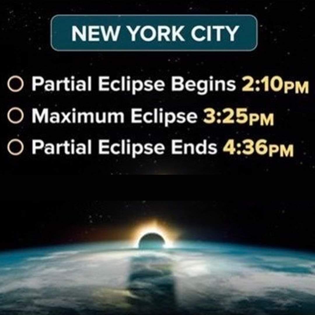
Everyone have their glasses ?
-
1
-
-
29 minutes ago, LibertyBell said:
it's going to be at 6:04 in the morning on May 1, it's 10 min after sunrise.
you don't work at 6 AM do you?
What
-
1
-
-
22 minutes ago, TriPol said:
The next time a solar eclipse will be visible in New Jersey or NYC will be 2079. Get out there and enjoy it!
People will enjoy it if they are off from work. Many people work.
-
Are kids off from school in your area? Schools are open here.
-
34 minutes ago, Brian5671 said:
Sure it's once in a lifetime for many
That's if you can even get off from work .
Meh I don't really care about this like others. It will be cool to see though .
-
Are people actually taking off for this lol
-
1
-
1
-
-
1 hour ago, snowman19 said:
Very confident we see our 1st 80+ degree high temp in the metro area since October by the end of this month
Hope not
-
3
-
2
-
-
I'm working so I'm staying put.
-
1
-
-
25 minutes ago, snowman19 said:
When you look at the synoptic picture (rapidly developing La Niña, -PDO, ++AMO) that actually points to anything but a cool summer, actually points to a SE ridge on roids summer. The high soil moisture does point to wet/humid
This
-
13 minutes ago, CoastalWx said:
We nude starting tomorrow
Nude in the rain on Thursday
-
1 hour ago, Allsnow said:
Another 1-3 of rain next week…sigh
Bring it on
-
1
-
1
-
3
-


April 2024
in New York City Metro
Posted
First time this season I'm wearing short sleeves without a jacket .