
.png.077deb4d0b08726b9bd916fd6b3e3ccb.png)
Weather Mike
-
Posts
151 -
Joined
-
Last visited
Content Type
Profiles
Blogs
Forums
American Weather
Media Demo
Store
Gallery
Posts posted by Weather Mike
-
-
5 minutes ago, TheRegionRat said:
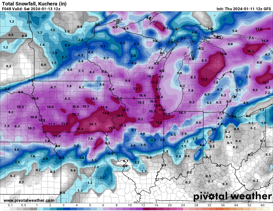
After reading the KLOT AFD, are the Euro and 18Z GFS snow maps over-cooked?
Its like KLOT is taking into consideration the lake but the GFS and some others say screw the lake ?
-
1 minute ago, SchaumburgStormer said:

love that run. On my way to Chicago now. I know the lake will affect accumulations but I still love seeing those numbers on the recent 18Z
-
Just now, Sciascia said:

Thanks for posting that. To me the Euro and GFS have been similar and consistent lately with this event. I hope it does come to fruition.
-
 1
1
-
 1
1
-
-
20 minutes ago, SchaumburgStormer said:
Low takes a slightly more northerly route but the WTOD stay a bit further SE.
If I’m LOT, I’m hoisting WSW for the 88 corridor and north, and WWA for the area south. Then just have to see how the chips fall
How does the 12Z Euro look especially for Chicago ? Is it similar to the 12z gfs?
-
6 minutes ago, Radtechwxman said:
Comical that gfs hammers areas all over me and has a void over Peoria County where I am #weatherdome
GFS has been very consistent. Good to see that trend ....if it unfolds that way
-
13 minutes ago, SchaumburgStormer said:
Most of the short range models were too far NW with the last storm at this range, fwiw
I like at least how still the GFS and Euro are not NW and more in agreement give or take a little unlike the NAM etc.
See what the 12Z shows.
-
1
-
-
13 minutes ago, A-L-E-K said:
choose your fighter


What a difference this close to the event on these two model runs from Milwaukie to CHI
-
6 minutes ago, ducky said:
Here's my thoughts for Chicagoland on the upcoming storm...
Initial Phase (Late Thursday Evening to Early Friday Morning): The initial phase of the storm is characterized by the incursion of a robust, moisture-laden baroclinic zone, propelled northward from the Gulf of Mexico. This influx of moisture, encountering the antecedent frigid air mass entrenched over the Midwest, sets the stage for rapid cyclogenesis. The isentropic lift, augmented by the lake-enhanced orographic effects of Lake Michigan, initiates a steady snowfall. During these initial hours, light to moderate snow is expected, with accumulations gradually building, particularly in areas of enhanced vertical lift.
Peak Intensity (Friday Afternoon through Late Friday Night): As the central pressure of the cyclonic system deepens and tracks northeastward, aligning its trajectory with the axis of the upper-level jet stream, Chicago finds itself within the left-exit region of the jet streak. This positioning is crucial for enhanced upward vertical motion, leading to the intensification of snowfall rates. Model guidance suggests the potential for thundersnow, where convective elements within the stratiform precipitation band could lead to brief, intense bursts of snowfall. Accumulations are expected to be most significant during this period, with snowfall rates potentially exceeding 1-2 inches per hour, exacerbated by the strong northeasterly winds creating blizzard-like conditions and significant drifting.
Tapering Phase (Early Saturday Morning Onwards): As the system progresses eastward, advecting the primary moisture feed with it, snowfall intensity in Chicago will begin to wane. The post-frontal environment, dominated by a high-pressure ridge, will usher in drier air, leading to a gradual cessation of precipitation. However, residual cyclonic flow and lake effect processes may continue to contribute to light snow showers, particularly in areas adjacent to the lake. The aftermath of the storm will leave a significant snowpack, with total accumulations potentially reaching or exceeding the forecasted 20 inches in some locales.
Appreciate the in-depth review for Chicagoland. It seems reasonable but is this for areas away from the Lake and north of the city ? Lots of talk of 3-5 inches max for city and lakeshore and rain for hours on Friday ?
-
9 minutes ago, Radtechwxman said:
At this point I would start trusting hi res guidance more over globals. 06z hrrr seemed to be finally in line with other models. Rap was still pretty nw.
Can anyone share one of the most recent high res model snow maps for the Illinois area ?
thanks
-
3 minutes ago, A-L-E-K said:
not our event
What would need to realistically happen as these models unfold and the system approaches to allow the metro area to avoid any rain ?
-
34 minutes ago, RCNYILWX said:
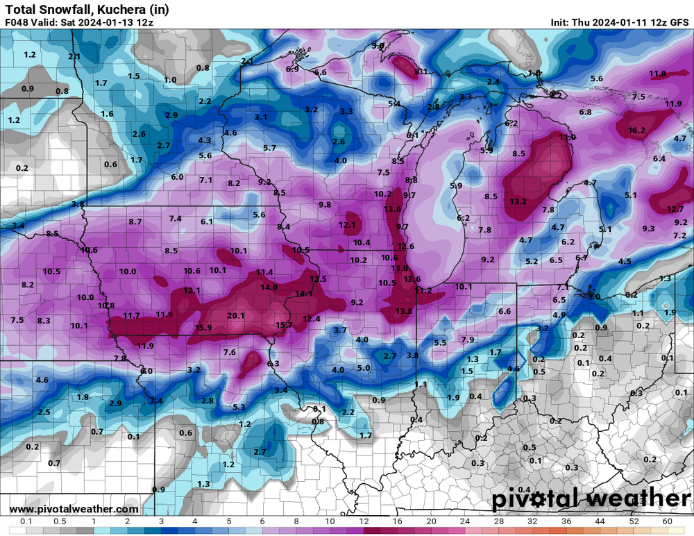
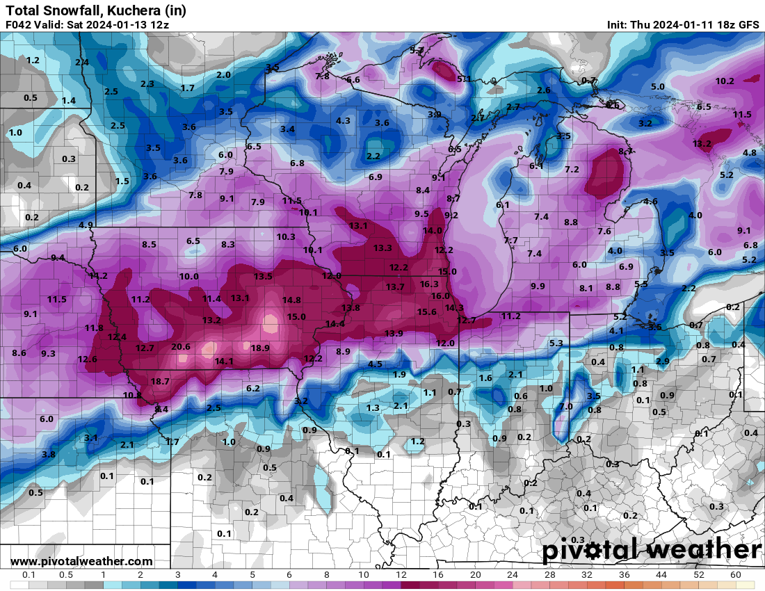
Here's the raw storm total forecast output, available at: https://www.weather.gov/lot/winter . The dark blue is 4-6", the light yellow is 6-8", orange is 8-12" and the darker orange is 12-18", in this case between 12-13".
For watch purposes today, was okay with this, but certainly might be too broad brushed and how far inland the marine influence extends is a challenging aspect of the forecast.
Sent from my SM-G998U using Tapatalk
Crazy how the lake I assume can reduce amounts and then you go just west a little and you are at 10 inches. That sucks for us near the shore or in downtown. Is there anyway that the shore or downtown can get in that 10 inch range ?
-
1 minute ago, RCNYILWX said:
I think even more than the temps, the Rockford area was plagued by subsidence holes yesterday between the prominent banding associated with the 700 mb deformation (eastern IA to far NW IL and SW WI) and the band that set up just north of the 850 mb low track and dry slot and hit parts of the interior metro hard. When you have marginal temps and subsidence, it's a recipe for an underperformer.
As things stand now, I think the RFD area is in a better spot to avoid that but too early to call, since mesoscale banding is one of the tougher things to pin down, especially at this range of the forecast when the system track is still in flux a bit. Then Friday evening, should still be enough forcing on the back side to wring out as much as a 0.2" QPF while ratios greatly improve.
Sent from my SM-G998U using Tapatalk
If you had to guess precip amounts for downtown what do you think is your call and could that change tomorrow based on future runs of the models or are you pretty set ?
-
4 minutes ago, RCNYILWX said:
Honestly, certainly couldn't discount a warmer outcome, but we were looking at a bit south of I-80 (aside from the very real lake influence) on too much uncertainty for a watch.
I do think it's going to be white rain near the lake on Friday, but my thinking is that the 700 mb and 850 mb low tracks with this per the very consistent ECMWF and recently more consistent GFS are more favorable to keep things heavy wet snow away from the marine bubble on Friday.
Definitely uncertain how far inland the lake influence on accums gets, but [mention=9209]mimillman[/mention] noting the difference between Wicker Park and the Loop yesterday afternoon swayed me to use the Dan Ryan as a rough demarcation zone.
I was most on the fence about Livingston (not included), Kankakee (included), and Lake and Porter, but IWX wanted LaPorte in and I was fine to put them in the watch for collab purposes. WPC has an internal watch proposal that actually had the whole CWA in it.
There was good agreement for the purpose of watch issuance in what we went with, and didn't consider not including central and southern Cook because of inland portions of those zones currently look good for warning level impacts per global consensus.
Officially had about 5" along the Chicago shore, which very well could still be a bit high depending on how long temps take to cool Friday evening.
So north of I80 and near the shore like downtown you are predicting around 5inches which could be on the high side?
-
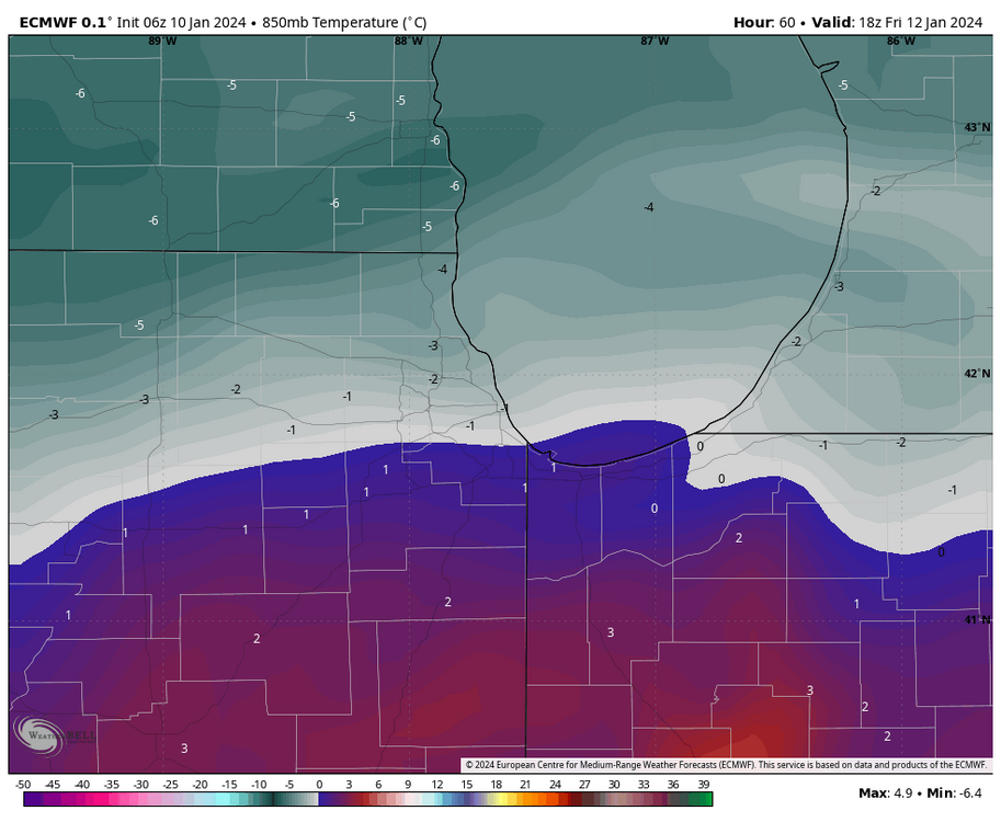
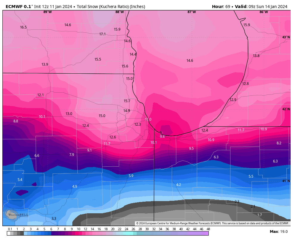
1 hour ago, mimillman said:
Once again the Euro manages to keep 0c 850mb south of the immediate metro, very different from last storm. Ratios will be very poor but this should be very heavy snow as progged. The NE burbs will do very well.
I made a final call of 3-5” for the city. That may still be accurate but could be low for the NW neighborhoods. ORD and northwest of there should be 6-10”
3-5 for the city seems very low. Most model runs support at least above 6-7 for the city and the Euro just showed 10+
-
 1
1
-
-
1 minute ago, Allsnow said:
Ukmet 10-15 for Chicago metro on 10-1 maps
thats great. Lets see what the Euro says a little later.
-
1
-
-
57 minutes ago, mimillman said:
I really hope Chitown can stay all snow. At least north of I 80.
Let’s see what the 12Z runs show. -
1 minute ago, HillsdaleMIWeather said:
.thumb.png.e364c4c6585894aa6a71095f2d0f5f95.png)
I will be in Chicago on Friday so I am for sure pulling for the Euro. Wow thats amazing. Lets see if the GFS folds to the Euro or vice versa as we go through tonight
-
Just now, WEATHER53 said:
I’m gonna say at 4pm Saturday presuming onset has not occurred it will be 42/22 at DCA .
I may have to go to the Baltimore game Saturday or Washington game Sunday if this continues to look good and based on the timing
-
6 minutes ago, Sey-Mour Snow said:
Looks like an hour burst of snow then several hours of light white rain on nam down here..

I may just head for the Catskills. Its been so consistent on almost every run to get nailed
-
1
-
-
18 minutes ago, 40/70 Benchmark said:
Tomorrow PM/evening.....no rush...most of this is Tuesday.
So you think if your chasing this and fly in Monday afternoon your ok ?
-
1
-
-
4 minutes ago, iBrian said:
Went out to shovel the over-an-inch of sleet / ice pellets in Mundelein - just changed over to snow.
Very nice
Here in Chicago not much but cold rain
-
10 minutes ago, madwx said:
the snow has been trending later as well. This used to look like a morning show here but now it looks like the majority of the snow will fall after noon
Flying into Chicago tomorrow late morning and enjoying the trends further south allowing more snow into Chi town. Better then rain. I will even take some mixed bag of stuff.
-
52 minutes ago, hawkeye_wx said:
12z Euro... at least it's no worse for me than the last run. I'm sure DVN does not want to issue a warning and then cancel it 12 hours later for the second consecutive storm, but there is not much justification for the winter storm warning from Cedar Rapids to Dubuque now.
As we get this close should be put more focus on the models like the HRRR and others that are better in this close timeframe then the longer range models ? Just asking due to my ignorance. thanks
-
6 minutes ago, WestMichigan said:
Models seem to want to split Ottawa County in half and it looks like I am in the wrong half. I guess we will have to wait and see since the difference of a few miles might make a significant difference with the snow line.
Agree
I will be in Chicago and in one of those areas a 50 to 75 mile south movement means a lot
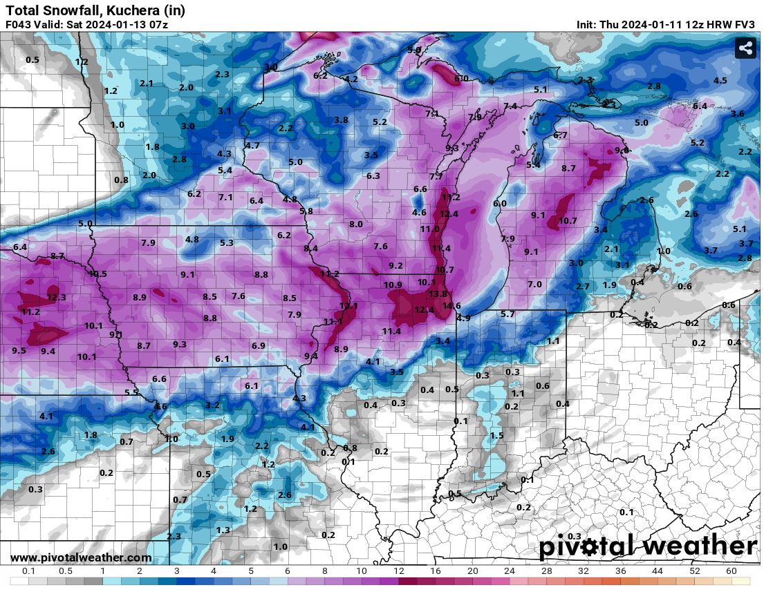

.png.fcb2ee972f5b8a3c315d116996344290.png)


Jan 11-13th Blizzard
in Lakes/Ohio Valley
Posted
I love that for Chicago !