

Tezeta
-
Posts
22,365 -
Joined
Content Type
Profiles
Blogs
Forums
American Weather
Media Demo
Store
Gallery
Posts posted by Tezeta
-
-
1 minute ago, smokeybandit said:
XCel energy is proactively shutting off power to a lot of homes on the front range until tomorrow. Seems a bit drastic, but then again they'll get blamed for wildfires if they didn't do it.
No email from xcel for me. Fingers crossed. My development is all buried so hopefully will be fine.
-
1 hour ago, Chinook said:
this is more of a cold upper-air event, which might be called a "bora," which is one of two downslope wind types (katabatic and adiabatic, Foehn and Bora, from the Alps in Europe.)
NW wind gusts of 41 kt next to SE wind gusts of 38 kt
My understanding is that the first half of the event is bora, switching to chinook later tonight. This is based upon last nights boulder forecast discussion, but I’m not a met. Either way it sucks.
-
This is my first major chinook event. Have no idea what to expect. Hopefully my proximity to 25/the plains helps cut down my max gusts. I'm supposed to pick up my wife at DIA tonight and am hoping her flight just gets cancelled.
-
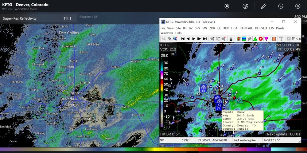
maybe 1" now in foco. what a banger.
-
Just now, Ahoff said:
What does the sock thing mean? I've seen it mentioned a couple times.
A sock puppet is an alternate account designed to disguise the true author
-
 1
1
-
-
1 minute ago, Ahoff said:
You brought up the discord, and got him started on it, lol. It's okay though.
I just thought it was weird that western PA drama was spilling over into a relatively unrelated place.
-
Did kpit actually steal food he was dashing?
-
34 minutes ago, Ahoff said:
I can’t help that people are sick of you everywhere. But I am only sick of you here.

-
I’m ready for winter to end…please make it stop
-
Just now, Ahoff said:
lol, hope you’re joking, because I’m literally on 0 other sites.
i cant verify who is who. I just know that @KPITSnowwas being screenshotted elsewhere, by anonymous socks, and I thought it was kinda scummy.
-
1 minute ago, Rd9108 said:
Do we have a pittsburgh weather discord?
If you guys did I would join. I am from western PA originally.
-
Just now, KPITSnow said:
Do you have a link by chance. They have been doing it for years and I am tired of it.
Do you have discord? That’s where it was. It’s not just like a url I can send you
-
Just now, KPITSnow said:
Not shocking. I’m guessing it’s the same person.
I can’t verify any of that. They’re using socks there as well. Someone called “the luxury of dooming”
-
8 minutes ago, KPITSnow said:
I’ve seen these folks on other sites screenshotting your posts and talking about how much you suck. You should know they are talking behind your back too.
-
50mb should be plenty. there are people here using modems and we have to be mindful of bandwith.
-
-
WWB is going to lead to twinsies next week
-
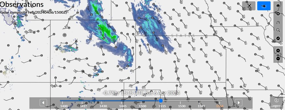
16 hours ago, Chinook said:
Snow bands have shifted around the area all day. I think Fort Collins may have gotten a lot as the snow started early
I probably got around 6”. The ground ate a lot of the snow. My neighborhood still has mostly clear sidewalks but the cars all have a nice thick layer.
-
13 minutes ago, Amped said:
Despite being small you couldn't have asked for a worse track. It dragged along the coast and everywhere between the International Airport and Pie Del la Cuesta got hit by the eyewall, including the tourist district on the west side of the bay. At least that's my guess based on the damage.
exactly. so much depends on track. we have had some crazy storms but nothing this perfectly aligned for destruction.
imagine:
andrew slightly further north
hugo further left of charleston
laura 30 miles west.
michael slightly more west
etc etc
that's what happened here. one of those scenarios...
-
 1
1
-
-
9 minutes ago, Normandy said:
Worst wind damage since andrew, and the more that comes out there is a case being made for worst urban wind damage ever produced by a tropical cyclone globally.
Depends on how you categorize Tracy. It was urban. And it was wind damage. But the buildings were sticks. These are modern condo buildings and a mall just shredded.
-
10 hours ago, Normandy said:
There will be studies and papers written about this storm, but the one thing that strikes me with this is the insane amount of damage it produced for being such a small cyclone with such little duration of max winds. There are a handful of curious cyclones that fit this bill (cyclone Tracy, charley, even Patricia in a weakened state, and to a lesser extent Andrew because it wasn’t micro sized). I wonder do Mets here think there is a certain increased violence or vorticity with these small cyclones that caused greater wind damage? Maybe I’m off base here, but interesting to think about.
9 hours ago, Floydbuster said:I think the smaller the radius of maximum sustained winds, the most concentrated the wind gusts are. Not to mention the lower the pressure, you wind up with a steep pressure fall the smaller the eye is.
This just hit the right spot. I don’t think the winds were special because of its small size, beyond the usual mantra of small storms can wind up quickly.
-
2 minutes ago, psv88 said:
Hamas?
Trans hamas.
-
1 hour ago, MattPetrulli said:
Norfolk Airport, over 250 miles+ away, is sustained at 40 MPH gusting to 53 MPH. Impressive wind field and on ground verification. Even Wallops Island, Delaware is sustained at 36 gusting to 51.
RIP
-
 1
1
-
-
1 minute ago, NorthHillsWx said:
I cannot emphasize how crazy I think record would have been for Jova last evening. I truly think that was one of the higher end of higher end storms in our lives. We’ll never truly know how strong it got but it’s structure was perfect and the pinhole eye was terrifying
Jova was pretty good last night but go review Rick, Linda, and Patricia. There is another level the EPAC can occasionally pump out.
-
2
-


Mountain West Discussion- cool season '23-24
in Central/Western States
Posted
it's ripping here in north fort collins...not as bad as it is a few miles up the road, though.