

flsch22
-
Posts
52 -
Joined
-
Last visited
Content Type
Profiles
Blogs
Forums
American Weather
Media Demo
Store
Gallery
Posts posted by flsch22
-
-
Fort Belvoir low of 15. Surprised how low that station gets being close to river and often colder than IAD. Open field/lack of surrounding concrete perhaps?
-
Quote
Aside from this 24-hr current transient shift to a neutral PNA, when the PNA is progged to actually shift to negative and is under 100 hours out, then our window is opening. Until then as we enter Jan, we are going to be relying on historic climo, and I'm not sure we can count on this like we did 15 years ago.
Thought we wanted a shift towards +PNA ?
-
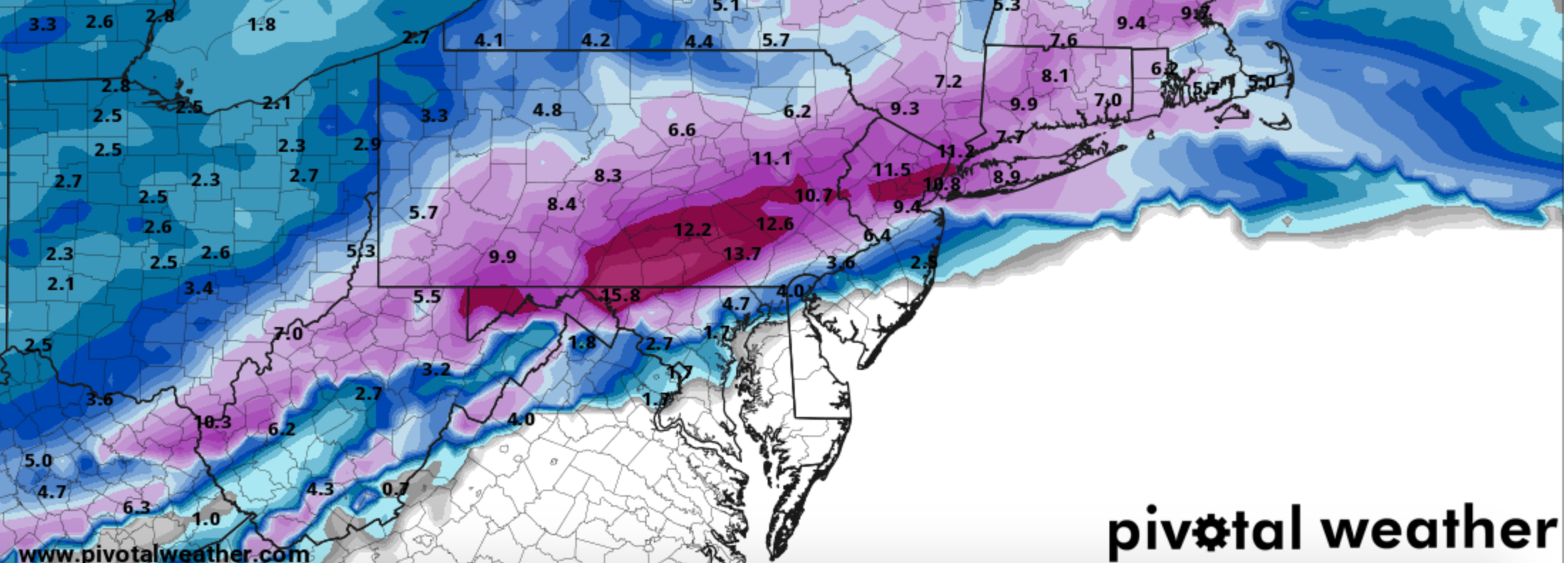
BWI: 5.3
DCA: 1.3
IAD: 7.2
RIC: 6.4
SBY: 4.6
Methodology: Fringed by several Miller B's and one southern slider + one fantastic storm track but BL temp issues = minimal accumulation
-
almost nothing here close to Beltway. inside beltway some brown/dying leaves showing up.
-
DCA: 12/05
IAD: 10/29
BWI: 10/29
RIC: 11/27
2.10"
-
HI was 99 at DCA and IAD last hour. that should be close enough
-
apparently LWX doesn't issue heat advisories anymore
-
 1
1
-
-
biggest ice storm of the season
-
1
-
-
40 minutes ago, Ji said:
lol the NAM finally gave me snow and its still sleet

wow, look at the position of that low. And we still can't get it to snow. #WinterIsBroken
-
over one inch of ice! hope that was a typo. otherwise, better find some candles and prepare to lose power for days
-
Agree with weighing seasonal trends. This is looking very familiar to the 1st storm of the winter (way back in mid-December) for my backyard. 1-2 inches of snow then a mess. Probably less rain this time which would be an improvement.
-
3 minutes ago, EHoffman said:

yikes, that's what I figured. Thanks for sharing!
-
1
-
-
NAM snow maps must not have been very good, or not out yet?
-
you may also want to consider the Adirondacks. We have a place in Lake Pleasant and the region is beautiful. Not as much lake effect snow but probably get more from coastals.
-
1
-
-
4 pm Temp on Monday, 2/15
DCA - 42
DFW - 22
DEN - 20
Low temperature for Tuesday, 2/16
DCA - 31
DFW - 7
DEN - 3
-
back edge approaching on radar already
-
 4
4
-
-
20 minutes ago, WxUSAF said:
Noon temps of 39 at BWI and 41 at DCA. Not bad and that’s probably the high with overcast skies now.
DCA will spike a 45 or 47
-
1
-
1
-
-
40 minutes ago, high risk said:
FWIW, the GFS Para (GFSv16) has been scoring well in the past week. Here the day 5 scores for 500 mb heights over the Northern Hemisphere (GFSv16 is purple):
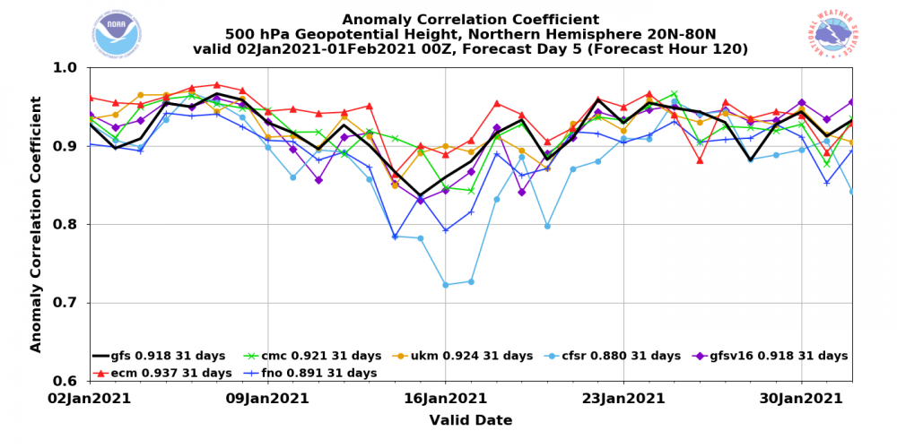
That's just for the 500 flow over the entire Northern Hemisphere, and it doesn't mean that it nailed specific details for the storm, and it also doesn't mean that it will be awesome handling next week. Definitely encouraging, though!
EDIT: to be fair, ALL of the models have been scoring well, so the pattern has been generally predictable. Perhaps that will be changing....
Thanks for sharing this. Curious is the FNO the ICON? What's the CFSR? Thanks
-
3 minutes ago, JakkelWx said:
NWS New York just went for 18-24 inches for NYC and surrounding areas but who gives a crap about what they get
yeah congrats I suppose. Another 40 inch winter looking likely for them. Meanwhile think DCA broke an inch today?
-
good bit of sleet mixing in with light snow now. game over.
-
2.00 inches in Fairfax. Hasn't accumulated much in past two hours. Starting to think 3" might be a reach.
-
reminding me of a storm late Jan 2004 - Miller B - think we ended up with 2-3 inches around beltway but was supposed to be close to a foot
-
Just now, North Balti Zen said:
I kinda had my hopes set on 6-10. So, yeah, trending toward 3-6 if we get lucky on the backside is kinda sucky.
me too, I would never complain about 3-6 but worried this is now headed towards a complete Miller B screw job where we get an inch and then watch clouds
-
mostly snow now, deck covered
Jan 15-16 Storm Thread 3: Obs and Disco
in Mid Atlantic
Posted
streets wet, white rain