

TimB
-
Posts
14,880 -
Joined
Content Type
Profiles
Blogs
Forums
American Weather
Media Demo
Store
Gallery
Posts posted by TimB
-
-
Overperformed our way to a 3rd 80 at PIT today. None of the days were forecast to get there.
-
4th year in a row that the temp has hit 82 before the halfway point of April. This had never happened in 3 consecutive years prior to this streak.
-
Interesting the way the western end of that line just died. We just seemed pretty starved for moisture which is fine after the last week and a half.
-
6 minutes ago, Voyager said:
I guess it's time to tell you guys.
This past Tuesday, I lost my mom. She passed peacefully late afternoon. She couldn't overcome the digestive system infection (c diff) that she contracted while in rehab for a broken hip.
I sat with her, holding her hand as she slipped away to the other side, reiterating that I loved her, but that I was ok, and that I wanted her to be pain free, to see again, and be with my dad and brother again.
We had some differences of opinion while I was here, but I hope my being here in Arizona was a comforting factor over the past year and a half that I spent with her.
Sorry to hear, man. I know you did so much for her in her final years.
-
 2
2
-
 1
1
-
-
Officially the wettest spring day on record, surpassing last Tuesday.
-
Looks like so much more rain to come.
-
And just like that it’s the 2nd wettest April day ever observed at the airport.
-
1 hour ago, TheClimateChanger said:
Also, the wettest first 10 days of April on record. This doesn't include the approximately 1/2-inch that's fallen today. We may have a top 10 wettest April on lock by midnight.
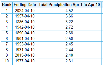
Looking at the weather records, there has only been one year with an April among both the 20 warmest and 20 wettest. April 1948 is 13th warmest in the threaded record (54.7F) and fourth wettest (6.03").
We’re now up to 1.52” at the airport today, so we’re already up to 4th with more rain tonight and 19 more days in the month.
-
9 minutes ago, TheClimateChanger said:
Accuweather suggesting we could approach a record high this afternoon. Yinz stay cool aht thar.
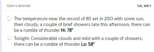
80 feels like such a soft record, considering we’ve been 78 in February and 80 in early March.
-
20 minutes ago, TheClimateChanger said:
My weather station showed a drop of nearly 8F, with solar radiation plunging to less than 5 W/m^2.
Hmm. Is PIT cooking the books?
-
Went up to northwest PA and watched the total eclipse. Interesting that the partial eclipse didn’t drop the temp at all at PIT, I thought that was expected even at 97% totality. Looks like Erie went 69 to 55 with the eclipse.
-
1
-
-
On this day last year it was 85 degrees. Today it’s snowing.
-
1
-
-
19 minutes ago, TheClimateChanger said:
They screwed that up. Whatever they did, it excluded non-leap years. 2020 is actually in 16th place.
-
Year to date precip is currently in 2nd place behind 2018, which of course was the record year (but a large amount of that precip from 1/1 through early April fell as snow).
-
Hell of a way to run a moderate risk.
-
Yesterday’s final official tally of 2.68” makes it the wettest spring day on record for Pittsburgh.
-
Obligatory “imagine if this was snow” post.
-
1
-
-
And still lots of rain to come through.
-
10 hours ago, TheClimateChanger said:
Wow, pretty crazy. April 1901 still takes the cake though.
2.05 inches of precipitation, and 12.7 inches of snow on April 3, 1901.

Later in the month, 1.53" of rain on the 19th and an additional 2.24" on the 20th.
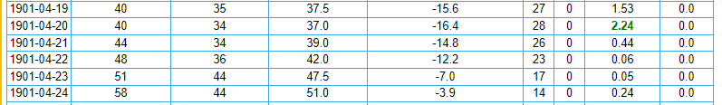
What a heartbreaker that must have been though for southwestern Pennsylvania, as parts of eastern Ohio saw up to 3 1/2 feet of snow. At least, the nearly 13" of snow earlier in the month would have provided some consolation.
Warren, Ohio
Gratiot, Ohio
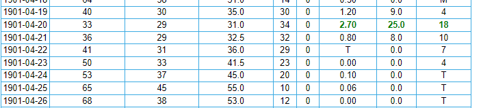
That April 19th-20th period in 1901 now stands as the only two day period in April wetter than yesterday and today. Today has now become the 4th April day on record with 2”+ of precip.
-
This is now the wettest April day ever observed at Pittsburgh international, with 1.62” and counting observed since 1am. The official all time record for any April day is 2.34” on 4/14/1922. We’re up to 6th on the all time list.
-
2 hours ago, TheClimateChanger said:
Wow. Not sure I've ever seen it this high for our region.

Last Day 2 moderate risk for anywhere in PBZ’s domain was issued on 7/26/2014. That system ultimately produced 2 hail reports and 8 wind reports in PBZ’s area, so we dodged that one.
-
11 minutes ago, north pgh said:
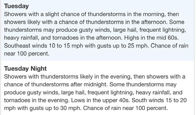
Flood Watch
National Weather Service Pittsburgh PA
148 PM EDT Mon Apr 1 2024

OHZ039-040-048>050-PAZ021-029-073-074-WVZ001>003-020345-
/O.EXA.KPBZ.FA.A.0003.000000T0000Z-240403T0000Z/
/00000.0.ER.000000T0000Z.000000T0000Z.000000T0000Z.OO/
Tuscarawas-Carroll-Coshocton-Harrison-Jefferson OH-Allegheny-
Washington-Westmoreland-Higher Elevations of Westmoreland-Hancock-
Brooke-Ohio-
Including the cities of Canonsburg, Monessen, Lower Burrell,
Malvern, Ligonier, Carrollton, Washington, Steubenville, Donegal,
Murrysville, Weirton, Dover, Greensburg, Wellsburg, Coshocton,
New Philadelphia, Wheeling, Follansbee, New Kensington, Latrobe,
Pittsburgh Metro Area, and Cadiz
148 PM EDT Mon Apr 1 2024

...FLOOD WATCH IN EFFECT THROUGH TUESDAY EVENING...

* WHAT...Flooding caused by excessive rainfall continues to be
  possible.

* WHERE...Portions of east central Ohio, including the following
  areas, Carroll, Coshocton, Harrison, Jefferson OH and Tuscarawas,
  Pennsylvania, including the following areas, Allegheny, Higher
  Elevations of Westmoreland, Washington and Westmoreland, and West
  Virginia, including the following areas, Brooke, Hancock and Ohio.

* WHEN...Through Tuesday evening.

* IMPACTS...Excessive runoff may result in flooding of rivers,
  creeks, streams, and other low-lying and flood-prone locations.
  Creeks and streams may rise out of their banks. Flooding may occur
  in poor drainage and urban areas.

* ADDITIONAL DETAILS...
  - Multiple rounds of showers and thunderstorms are expected
    through Tuesday evening. Each will have the potential to
    produce heavy rain, with a cumulative effect evolving to
    create increasing potential for excessive runoff with each
    successive round. Total rainfall estimates through Tuesday
    evening will likely reach 1 to 2 inches across the Watch
    area, with locally higher amounts up to 3 inches possible.
  - http://www.weather.gov/safety/flood

PRECAUTIONARY/PREPAREDNESS ACTIONS...

People in the watch area, especially those living in areas prone to
flooding, should be prepared to take action should flooding develop.
Monitor the latest forecasts and be alert for possible flood
warnings.

&&
Severe risk also seems to have really amped up with latest guidance.
SPC sounded the alarms with their latest outlook:
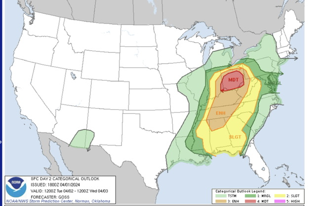
And PBZ introduced this to the zone forecast for Allegheny County:
-
Trying to figure out how PIT only topped at 96 in that heatwave.
-
1 hour ago, TheClimateChanger said:
When will be our first below normal month? Any guesses?
I’m going to go with August 2025. It’s the month that has gone the longest without being below normal (last time was 2017, which broke a streak of 18 straight above normal months), but it’s going to be a hot summer and won’t happen this year.
Pittsburgh/Western PA Spring 2024
in Upstate New York/Pennsylvania
Posted
Nothing awful. Few sub-severe gusts with the front end of the line as it moved in and some thunder and lightning, mostly several miles away.