

WXNewton
-
Posts
302 -
Joined
-
Last visited
Content Type
Profiles
Blogs
Forums
American Weather
Media Demo
Store
Gallery
Posts posted by WXNewton
-
-
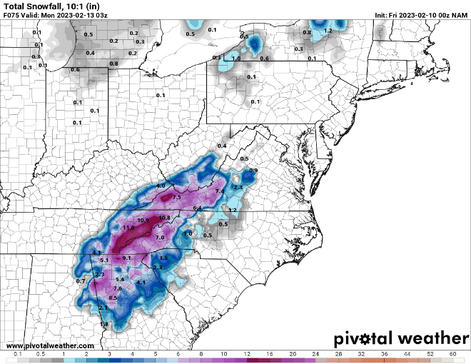
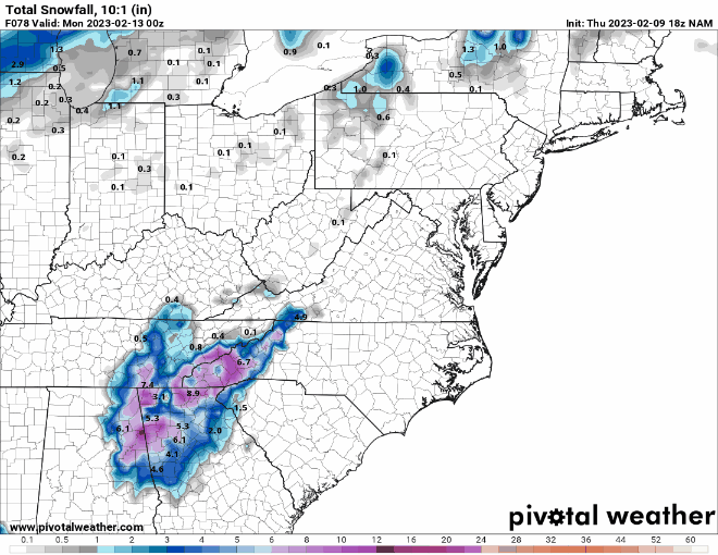
Last 3 runs on the NAM...
-
18Z NAM to 00z NAM
-
 1
1
-
-
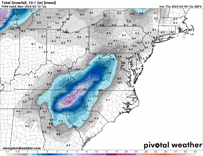
12Z GEFS and 18Z GEFS- uptick in the NW Piedmont and foothills.
-
3
-
 1
1
-
-
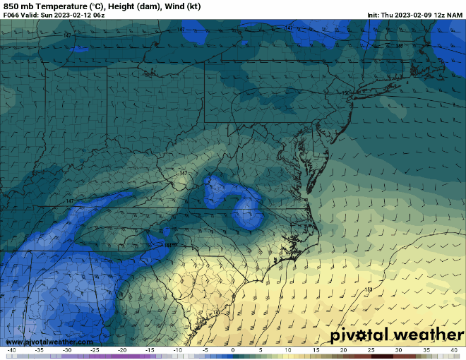
The NAM was an odd run, the moisture just disappears from hr69 to hr72.
-
1
-
-
3 minutes ago, Upstate Tiger said:
At 60
big difference in 850s hr 60 when compared to 12z
-
-
6z GEFS did increase totals over 00z.
-
1
-
-
2 minutes ago, calculus1 said:
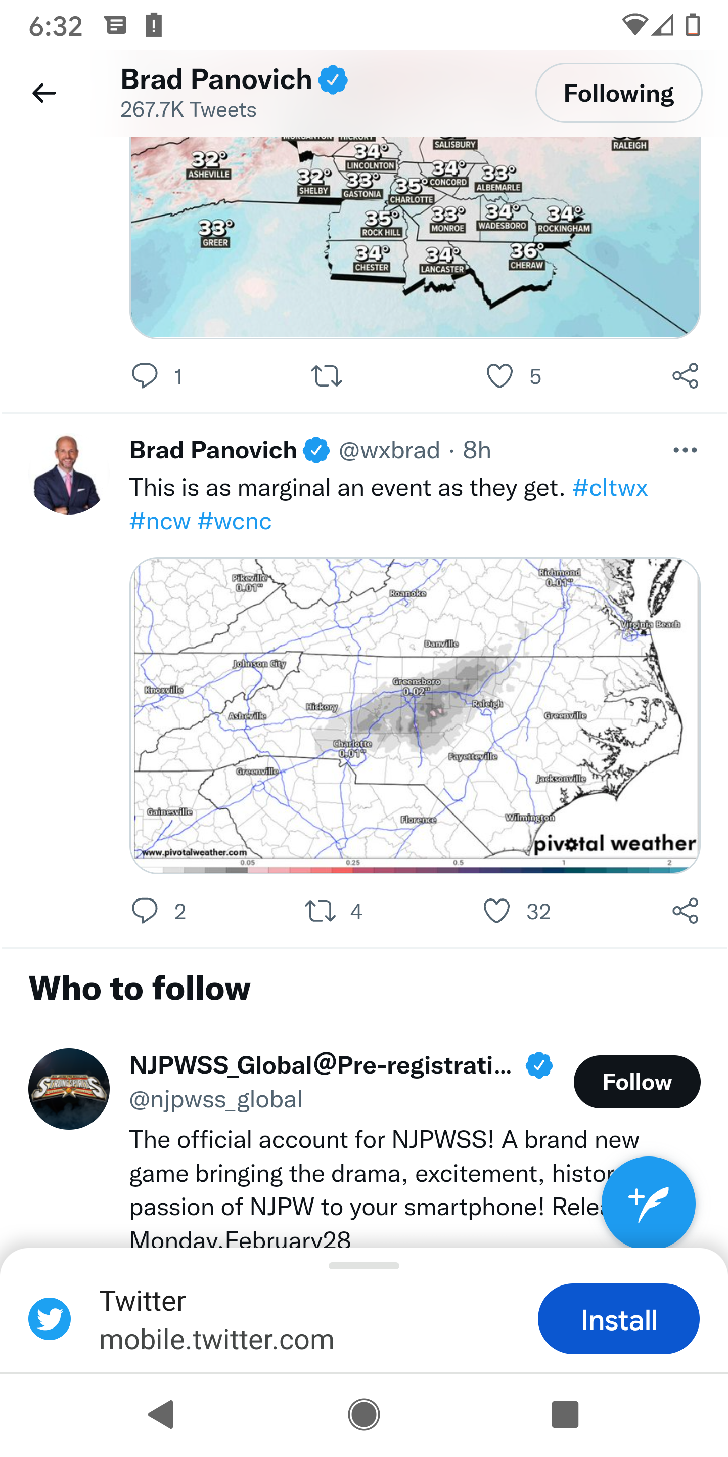
Wow! That's significantly more icing than we got in NW Hickory. Newton is further to our SE, but it appears you got the goods, there. Incredibly long icicles for something that was supposed to be so minor.
Yeah was really impressed with the amount that built up. Also stayed 29.6-30.4 for most of the precip. Definitely the most ice we've had in the trees in a few years. Also saw a few limbs and pines snap about 2 hours ago, mostly falling off now, but happy to see it all take place. Ice in the trees can make for a pretty scene out here in the country area.
-
-
2
-
-
31 minutes ago, PantherJustin said:
Before I fell back asleep… I saw 6Z GFS didn’t even initiate right also , still didn’t have barely any Precip into CLT Metro …. That thing is junk man lol
Hrrr, Rap sounded horn last night then NAM came in. Also the WRF-ARW2 was pretty spot on with temps and moisture. Of course RGEM was first to sniff it out. Euro was definitely better than GFS as well.
-
1
-
-
25 minutes ago, BG_Slick said:
Definitely some good ice accretion on our trees, cars, decks, grass and the trees are starting to sag here as well. Apparently roads / bridges are also affected based on many reported accidents in the Triad. I-40 Westbound at Harper Road was shutdown this morning after a 15 car pileup.
Freezing rain continues for now. Temp has been around 30 / 31 but now up to 32. Hopefully we'll get above freezing soon!
Definitely an overachiever here as far as ice goes. GFS did horrible with precip back to the west and the ice. RGEM sniffed it out first and stayed course with it. I've listen to constant scanner chatter from 4:30-9:45 wrecks every few minutes. https://photos.app.goo.gl/2VhcxMJfgxAZfgxp7
-
Probably close to .2-.25 here in central Catawba County. Definitely trees starting to sag.
-
At least .1-.15 in the trees here.
-
Just going to leave this here and there was also a video posted on Facebook about warm temps and absolutely no issues with roads. Really misleading when you are such a big TV met and people really listen to what you say. Listening to scanner now and 321 is solid sheet of ice multiple wrecks currently happening.

-
1
-
 1
1
-
-
Holding about 29.6 here, good build up starting in the trees and all elevated surfaces.
-
5 minutes ago, PantherJustin said:
Welp…. Here they come
Listening to scanner several accidents here now ongoing.
-
4 minutes ago, PantherJustin said:
Score one for the Short Ranges…..31/24 here in Mooresville , Radar looks decent , Raining now
All elevated surfaces frozen here and cars especially. Schools on a 3hr delay now
-
1
-
-
30.2 here in Newton all elevated and metal surfaces freezing over fast.
-
6 minutes ago, JoshM said:
FWIW, latest RAP has Charlotte at 0.28 freezing rain, was 0.04 last run
Yep increased ice totals and area now for 5 runs in a row.


-
Sounding for HKY tomorrow morning at 8 a.m.

-
1 minute ago, JoshM said:
What's making this trend colder, do we have some pseudo wedge or something?
I think it's more moisture being picked up by the models and more evaporative cooling taking place.
-
2
-
-
1 minute ago, wncsnow said:
Its increasing big time on every model I have seen. Could be a lot of people caught off guard tomorrow morning going to work in Hickory, Lincolnton, Shelby
You are exactly right and we've been seeing it for days but most of the mainstream news has just blew it off. I get it, we are use to seeing these setups trend away at the last minute, it's unusual to see it go the opposite way towards more ice for us.
-
Trend on the hrrr is big too!

-
Winter Weather Advisory now for Lincoln, Catawba, Iredell, Davie, Rowan. The last 4 runs of the RAP model keeps upping totals and expanding the ice in the piedmont.

-
2
-

Mid to Long Range Discussion ~ 2024
in Southeastern States
Posted
Definitely more organization in the central and western gulf on the Canadian and GFS 12z runs. Looks like the northern energy was weaker and allowed for more development of the southern energy, might just be noise at this point but something to watch over the next few days. ICON keeps a stronger northern piece and squashes any development in the gulf.