
Tobiewx
-
Posts
15 -
Joined
-
Last visited
Content Type
Profiles
Blogs
Forums
American Weather
Media Demo
Store
Gallery
Posts posted by Tobiewx
-
-
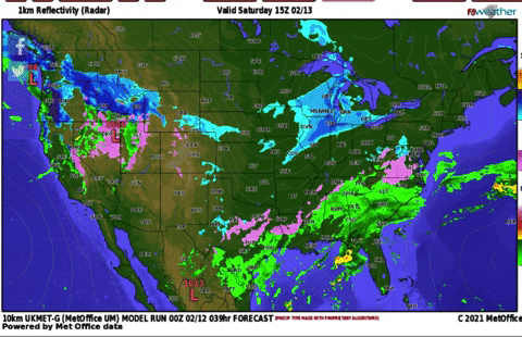
Currently sitting at 13 degrees with 3/4 inch of sleet/snow on ground, heaviest precipitation is close upon arrival, I’m just south of Memphis like 28 miles.
-
 4
4
-
-
Sitting at a balmy 18 degrees in North West Mississippi, been snowing lightly all day, we have a good dusting as of now.
-
2
-
 1
1
-
-
5 minutes ago, Matthew70 said:
Thinking this is west TN and middle continues its streak of Nada.
Well in most cases, when Dallas gets snow, normally that comes right up through even middle Tennessee, I believe middle Tennessee will not be shut out of this event, just may not be all snow, may be lots of ice to deal with, I’m by no means a meteorologist but I have lived in the mid south all my life and more times than not, when it hits Dallas, it normally moves right through the mid south into middle Tennessee, now there are occasions that this has not happened but this is a very cold airmass, we are not dealing with marginal cold here.
-
2
-
-
-
We have around a half inch here in north west Mississippi and still coming down pretty good.
-
8
-
-
1 hour ago, John1122 said:
I hate that this is the one system that ends up further east than modeled this year. I was hoping AMZ and our other posters out that way scored. Maybe some N.Ala or Southern Middle folks can get something going.
Probably the NAM being the NAM but the 3k drops 3-4 inches above Holston in Frozenhead and over Cross Mtn.
Hate that we missed this one as well, really my fear was this would go north west of me, never south east of me, it is what it is though.
-
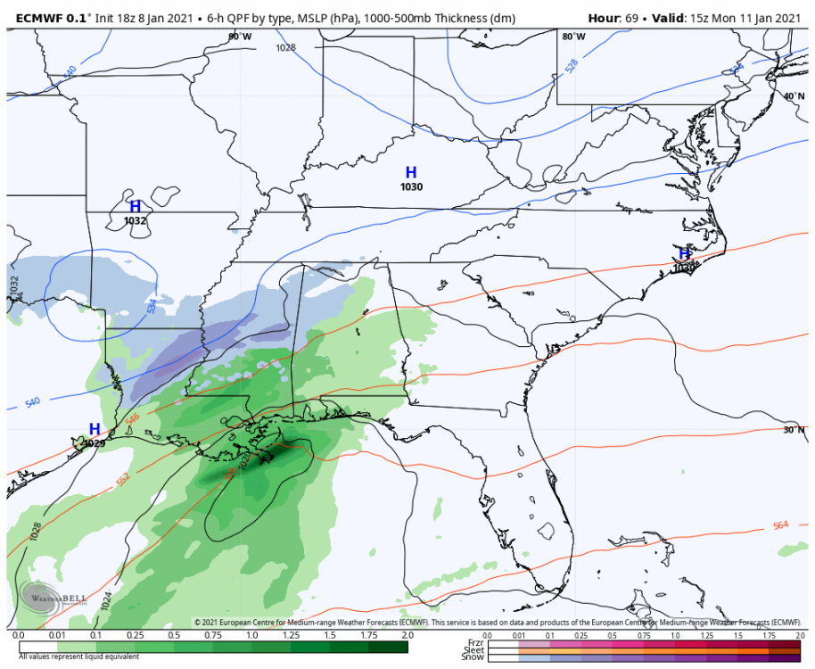
Well the 18z Euro is a no go, big swing and a miss. Not sure if it’s just not amped up or just getting shredded up


-
1 hour ago, John1122 said:
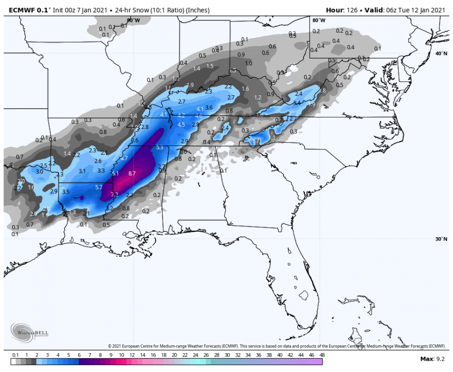
The 18z GFSV16, which has been working better than the GFS moved its snow shield a good bit N in North Mississippi from 12z to 18z. Also much better for NW Alabama than the prior run. The track is similar but it was better organized longer at 18z. The Euro from 0z last night to 12z today was a major improvement for N Miss too.

12z

Do you feel like this may move back northwest any with its track? Meaning do you think there is more of this coming north west than it’s has already done?
-
Let’s hope this one works out for the mid south, not betting the farm on it
")
-
1
-
-
19 minutes ago, Carvers Gap said:
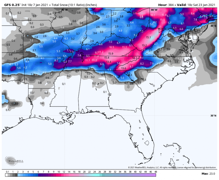
Total 18z GFS snowfall for the sub forum are is probably worth a post if someone has it.
-
11
-
-
25 minutes ago, AMZ8990 said:
.DAYS TWO THROUGH SEVEN...Friday through Wednesday

Another round of rain and snow is expected Sunday night, Monday
into Monday night with the highest chance of precipitation over
North Mississippi. Any snow Sunday night will likely change over
to rain Monday, then back to snow Monday night. No accumulation is
expected. Elevated roadways could become slick late Monday night
into early Tuesday.
NWS Memphis is mentioning the Sunday through Tuesday threat in their hazardous weather outlook.
They been burnt to many times, so they will approach this with caution, can’t blame them, at one time the mid south had no problem with these but as of late these things can change at last minute.
-
2
-
-
6 minutes ago, John1122 said:
Right now the EURO is the furthest north and west, which is one of it's biases. GFS is way East which is one of its biases. The Canadian was middle ground and was basically great for Mississippi and most of Tennessee. Especially along and S of 40.
Only 5 more days to go
-
I’ll take that any day in north Mississippi, the Euro just keeps inching that low north every run since last nights run.
My concern is, how much further north will she come
-
5
-
-
Long time lurker here, decided to finally sign up, I enjoy all the commentary you guys bring.
I’m from North west Mississippi, we have been in a snow drought as of late, been a while since a good winter storm has hit my area, really hoping that changes soon, maybe as soon as next weeK.
-
4
-


February 17-18th Winter Storm Thread.
in Tennessee Valley
Posted
Sorry for the delayed response, took about a week off, I ended up with around 6 for the Wednesday event, storm total for all of last week was between 8 to 10 inches, was a great week, I had snow on the ground all the way up to this Wednesday, definitely was a history maker as far as temps go, only seen that one other time in my life time.