

Ed, snow and hurricane fan
-
Posts
1,594 -
Joined
-
Last visited
Content Type
Profiles
Blogs
Forums
American Weather
Media Demo
Store
Gallery
Posts posted by Ed, snow and hurricane fan
-
-
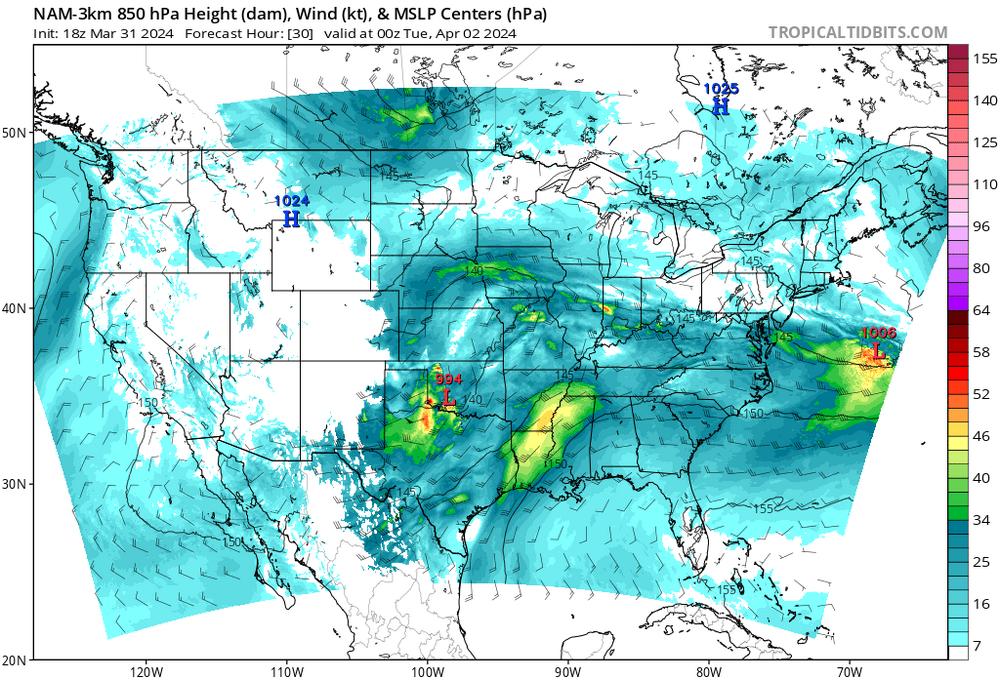
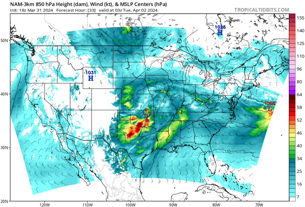
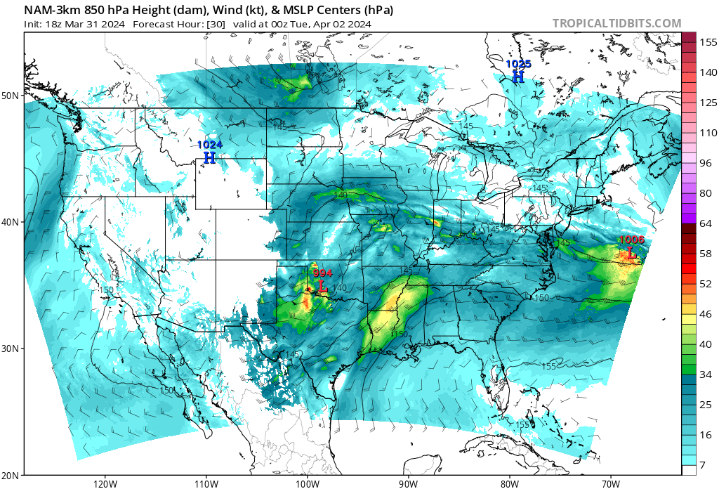
Updated SWODY 2 has two enhanced area, one in N Kansas and Nebraska, a second in W. Texas and Oklahoma, the TX/OK one being conditional on storms developing. 12Z HRRR thinks the dryline in Texas will go, to a lesser extent the GFS as well. 3 km NAM still shows a stout cap.
SWODY 3 mentions a possible increase from SLIGHT for the ArkLaTex area. Not seeing much on 12Z 12km NAM or GFS to support an upgrade, but it is at the limit of the NAMs.
-
 1
1
-
-
2 hours ago, Crazieman said:
Is there a discord or something everyone wandered away to? First nice looking severe event in my area in years and I come in to find it virtually dead?
It looked a lot better a couple of days ago on the models. It had looked like storms would initiate early evening at maximum instability. It is starting later, and low level instability is low. GFS showing elevated storms, NAM doesn't show anything. SPS forecast sounding below. It might work if a special 18Z sounding but it isn't. 30% at 5 days, that usually means a big outbreak. Still 3 day ENH, and SPC looks at stuff amateurs like me can't see or don't have time to see.

-
-
Baseball hail just N/NW of Austin. I assume this will grow upscale, may stay as far S as I-10 and wake me up an hour before my alarm is set for.

-
3 inch hail in PDS Severe Thunderstorm Warning just N/NW of Austin. Just heard it on Ryan Hall. Not on NWS yes. 3 inch hail.
Edit- I feel cheated, the words 'particularly dangerous' nor the letters PDS are part of the text.
-
Looks even better in a loop, but I don't have the attachment size left.
-
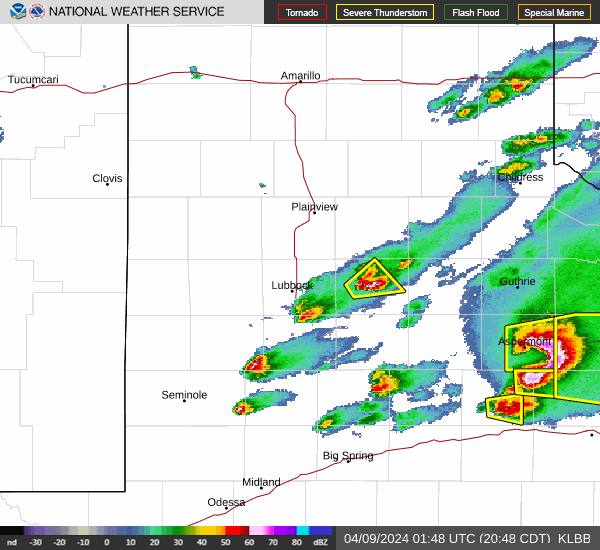
>80 dBZ with warned hailer E-ern Dallas County.
-
3 hours ago, GaWx said:
You’re welcome.
I’d like to make one more clarification. I wasn’t trying to say they’ve ended up too bullish on average with their April forecasts overall as they, indeed, have actually averaged too bearish with them overall. It is only when they’ve been their most bullish in April that they’ve averaged too bullish.For example, I’ll look at their 29 April # of NS forecasts. Although their five most bullish April forecasts ended up 2.8 too high on average, the 29 April forecasts (which include those five very bullish forecasts) actually ended up 2.7 too low on average! Interesting dichotomy of sorts.
I haven't compared as you have, but Dr. Klotzbach mentioned in his 2024 prediction recent April forecasts have improved. Hadley Cell talk makes me wonder, they don't (usually) have time to become extreme, but pieces of mid-level disturbances that break off and come back W as inverted troughs sometimes spin up. Locally (NW Gulf), Edouard and Humberto come to mine, Lee was badly sheared, making landfall in Louisiana with no rain of the W side in 2011, but it blew down the powerlines that started the Bastrop fire E of Austin. Rural country, but 1700 structures destroyed in 7 weeks, two dead. Even if the MDR is a bit suppressed, US threat is not zero. Alicia, last major to landfall inside NWS HGX CWA over 40 years ago, was of non-tropical origin.
First day of fire, I didn't think trees that green would burn. But rainless tropical storm and no rain all summer. Below video from day fire started, between Bastrop and La Grange.
-
DFW to SPS in an Enhanced for tomorrow, 30% hail and hatched. Late ahead of storms in the 287 area between the two cities, lapse rates in the hail layer between near 7 to near 8C/km, near 60 knot 0-6km shear per 12Z hi-res NAM. CINH is increasing, but enough 1 km helicity for a possible tornado.
-
94% totality down here. Can't wait for my mid day clouds become like 5 am clouds, before going back to early afternoon overcast.
-
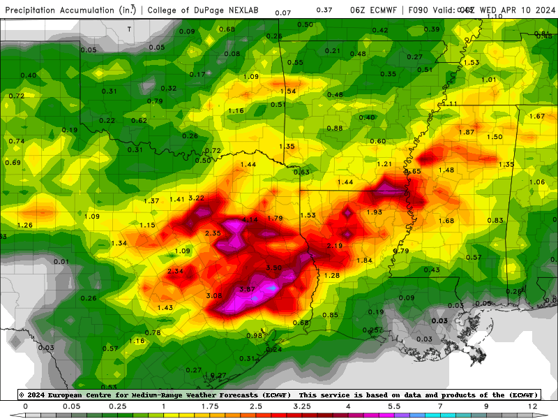
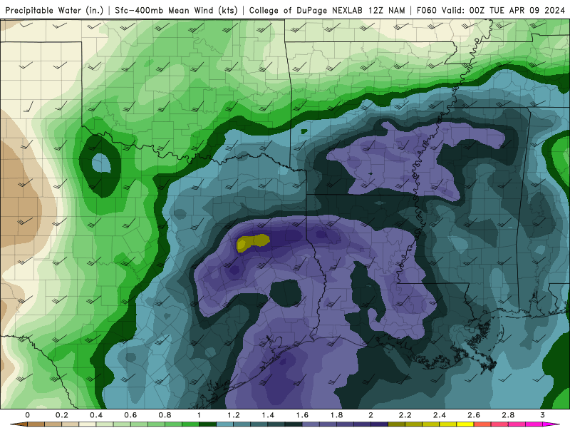
2 inch PW is more common in August. Severe signal is muted Monday in East Texas on NAM, long skinny CAPE from a near saturated sounding although impressive hodo, closer to I-35, nice EML and better CAPE, but hodos not good. 6Z Euro has widespread 4 inch 48 hour rainfall with near 7 inch bullseyes in Piney Woods. GFS not as dramatic and a smidge N, but a signal for excessive rainfall in N and E Texas. WPC has N and E Texas in a SLIGHT RISK area Monday and Tuesday for excessive rain. WPC 5 day QPF over 5 inches extreme E Texas to the ArkLaMiss.
-
Consistent signal (0Z, 6Z) NAM for an MCS to form over Central Texas and move E. NAM and GFS don't support, Canadian does.
-
At least San Antonio and Austin are in a Day 3 hatched sig-severe, language suggests for large to very large hail.
-
The same thing that made for a boring cold season might make this the year a major hurricane makes it to New England. The 26C isotherm in September usually gets as far N as the latitude of Delaware, it still won't reach the coast, but it'll be closer and the waters S of Long Island/SNE won't be so cold a storm falls apart quickly. OK, those of you on the coast might prefer snow to having a North Carolina-esque hurricane season (and mid-Atlantic type snowfall), but the trend in ocean temps doesn't seem in your favor. The AMO threw a head fake it might be headed back neutral about 2019/2020, but The two summers we rented a house in Harwichport, I was so early teen nerd excited about hurricanes. I was just born 50 years too soon.
I remember an April snowstorm on Long Island 1980 or so, when BOS was rain. @MJO812might know what year that was. But April snow is special.
-
I was never in a risk area, down in HOU we never get storms from a positive tilted trough except sometimes a 'squeegie line' (as the HGX mets call thin lines of showers or storms right on the front). But even yesterday, when DFW was Slight and OKC Enhanced, I did not see the low level response, and thus week low level winds, that would have done that much with the fairly 'meh' instability. I still think there might be a supercell or two with big hail and a non-zero tornado risk in N. Central Texas and Oklahoma. Could have been a big event with
Anything after dark that forms ahead of the squall line or in an embedded bow in E. Oklahoma might have a chance to go tornadic although CINH may be an issue. LLJ also picking up after dark, reaching 50 knots which could mix down
-
1
-
-
Just now, kdxken said:
Did your Cordoba have Corinthian leather?
Rich Corinthian leather. Sold it in 1985 when assigned to my ship, I paid too much for the POS and I felt guilty, the guy I sold it to paid my asking price. Burned oil like a mofo.
-
2
-
 2
2
-
-
If I had money to travel, I'd lean Lake Erie-ish. Far too early, of course. PW may not say much about high clouds, but the best thing I can think of for now. North Texas might have morning low clouds which usually burns off by 18Z.
-
29 minutes ago, Wx37 said:
Does the CP inside of 128 actually have a shot at seeing accumulations with this depiction or just a bunch of non-accumulating snow? What’s the temp profile?
Been right at 40 years, the last time I drove to BOS. They write tickets now, but I brought about 4 inches of snow from Saratoga Springs to Boston in 1984 on my 1976 Chrysler Cordoba. I don't see that many metro Boston posters, perhaps because it has been seasons of consecutive disappointment.
The NNE posters remind me of something I heard when I lived in the NYC area, snow in the Big Cities was good for ski country, it got some people thinking about skiing. It'll be almost another hour before 2m temps from Euro are available on the free sites. I myself am very curious about surface temps inside Route 128 and down to Marshfield.
-
1
-
-
SPC is Enhanced for Day 3 with a hatched SigSevere for the I-35 corridor in Oklahoma and a small part of SE Kansas and SW Missouri. Parsing the language, hail seems to be the biggest concern in Oklahoma but all hazards are possible. GFS doesn't look that exciting to me, nor the NAMs near the end of their range, but I'm assuming the SPC people know what they are talking about. Speed shear (and a lot of it, 70-80 knots, possibly why language about hail), but little change in wind direction surface to 500 mb. If models are right, I'd think any tornado threat would be tied to low level boundaries. The only one obvious at this time is the cold front/dry line, and surface/850 mb winds aren't that impressive.
Not seeing the MCS SPC thinks will develop late afternoon and evening, but again, at the farther edges of meso model range.
-
Rates so high time of day/sun angle doesn't matter?

-
2
-
-
My new favorite You Tube and Twitter follow... No video yet, but one is surely coming.
-
1
-
-
-
I'm guessing I'm not the first person on the board who started watching the videos, but YouTube somehow knew to suggest Convective Chronicles. Tropical Tidbit style discussions of ongoing events, and 45 minute post-mortems of significant tornado events of the last 30 years. On Twitter/X and YouTube.
-
Not hatched for large hail, but enhanced risk for hail probs >30% w/i 25 miles for a small part of N Central Oklahoma and S central Kansas on updated SWODY1
Texas 2024 Discussion/Observations
in Central/Western States
Posted
Been consistent for days, heavy rain N & W of Houston, NWS HGX has issued a Flood Watch for the counties North and West of Houston, including Montgomery County. HRRR is especially enthusiastic.
What has also been consistent, first on the globals, and now the mesos, a very sharp cutoff between heavy rain and much lighter rain.
Edit to Add: My son flying from DFW this evening and American has been delaying his flight. WPC has a meso rainfall discussion for pretty much the entire stretch of I-20.