

MN Transplant
-
Posts
16,358 -
Joined
-
Last visited
Content Type
Profiles
Blogs
Forums
American Weather
Media Demo
Store
Gallery
Everything posted by MN Transplant
-
April 8th Eclipse- Last Easy One To See In My Lifetime
MN Transplant replied to Interstate's topic in Mid Atlantic
https://weather.us/model-charts/euro Choose "All" under Parameter Selection and go down to Clouds. Select Ohio under Change Map Selection. -
April 8th Eclipse- Last Easy One To See In My Lifetime
MN Transplant replied to Interstate's topic in Mid Atlantic
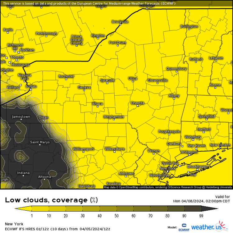
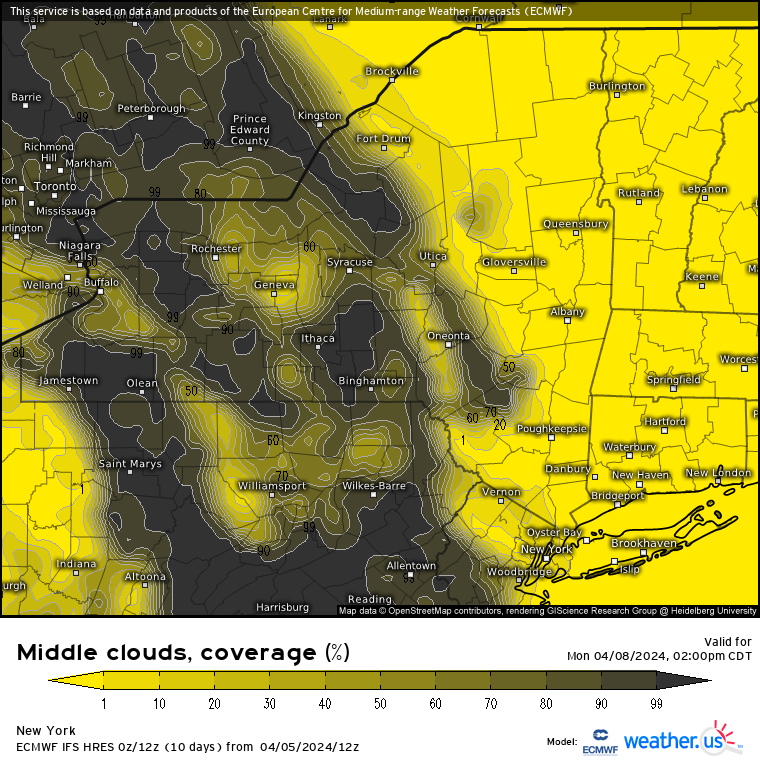
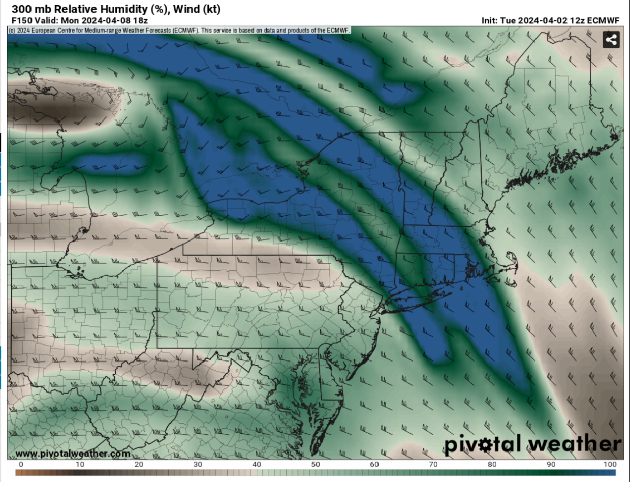
Ok, here's the 12z Euro for NY. Yellow is good, dark is bad. First up, no low clouds as we've been talking about. Splotchy mid-level clouds, and then an exiting deck of high-level clouds.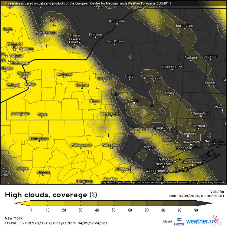

-
April 8th Eclipse- Last Easy One To See In My Lifetime
MN Transplant replied to Interstate's topic in Mid Atlantic
Not bad, verbatim. The algorithm says few clouds. Also looks good on the NAM.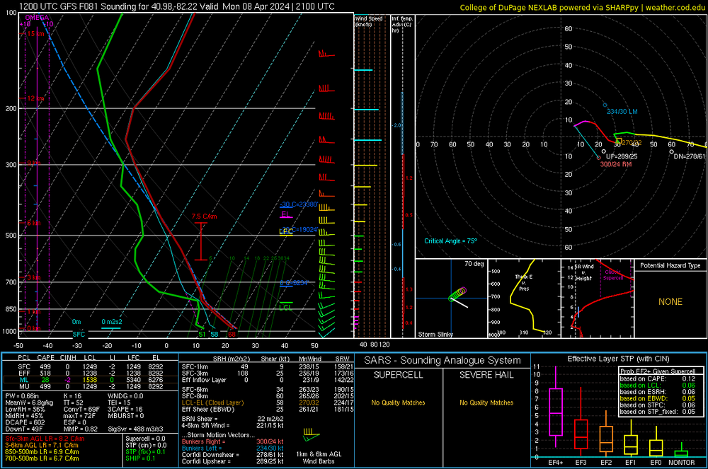
-
April 8th Eclipse- Last Easy One To See In My Lifetime
MN Transplant replied to Interstate's topic in Mid Atlantic
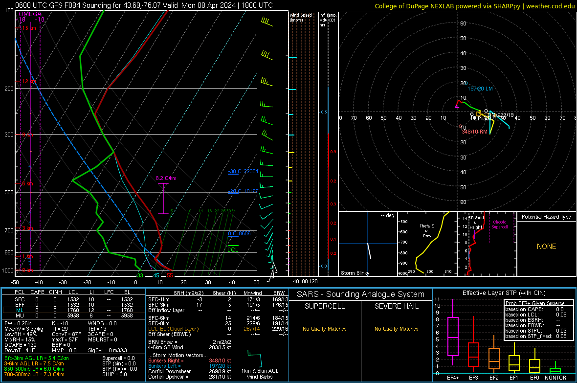
Better GFS run for NY.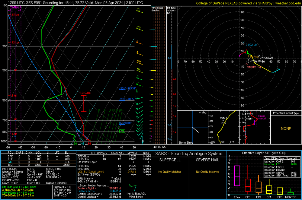
-
April 8th Eclipse- Last Easy One To See In My Lifetime
MN Transplant replied to Interstate's topic in Mid Atlantic
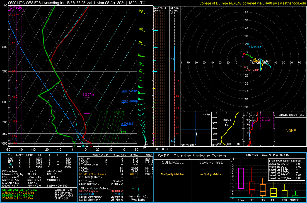
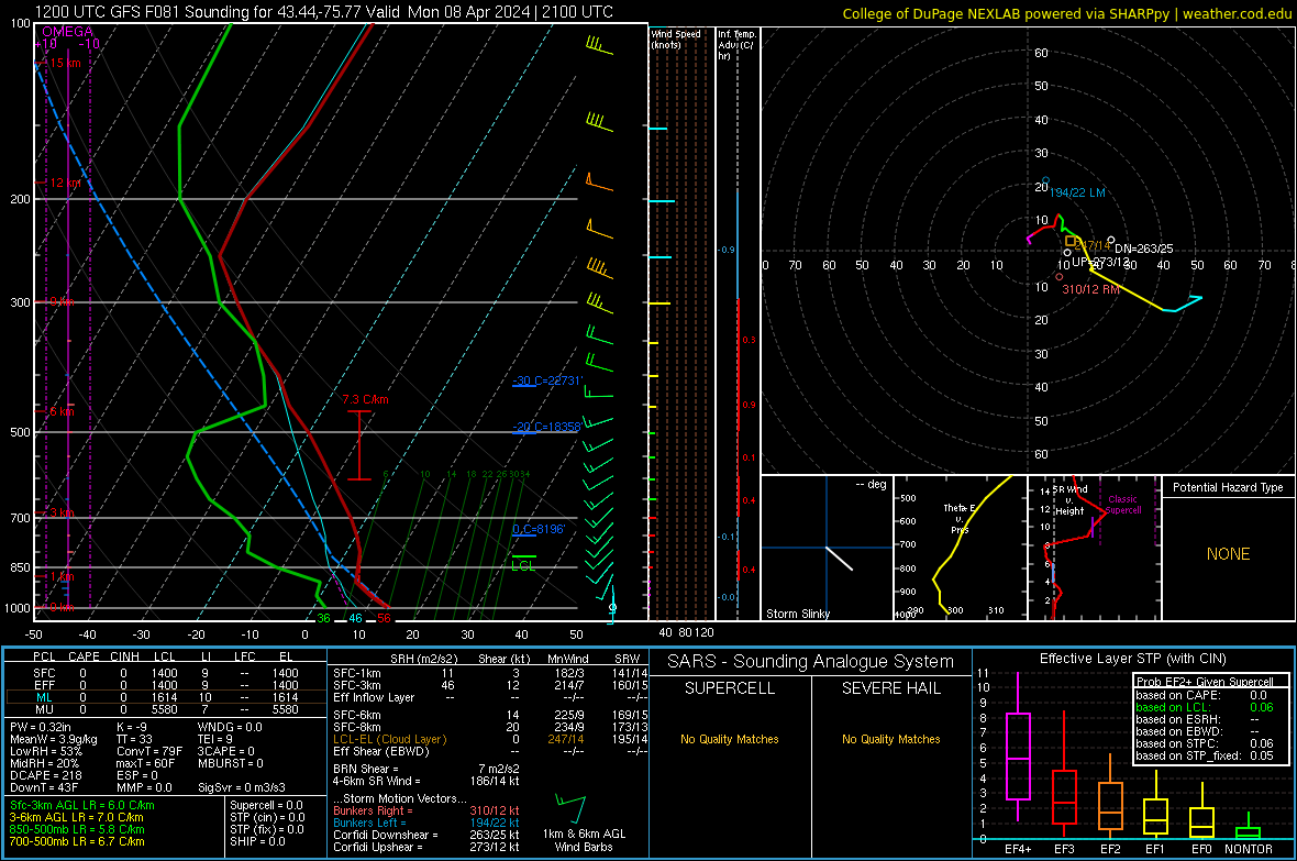
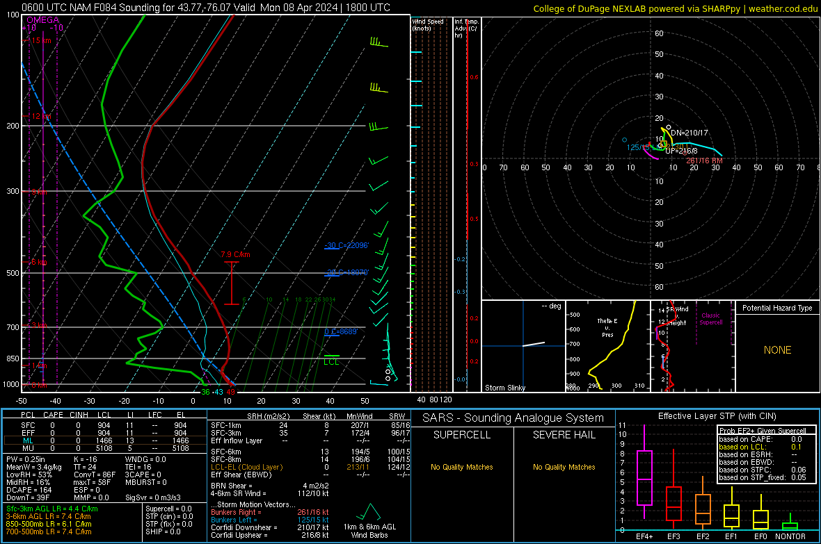
And we got one! Here's the big difference between the NAM and GFS. You can see the saturated layer from 250 to 350mb on the GFS sounding, which is our upper-level clouds. On the NAM, not so much. (edit - for the Watertown/Syracuse area)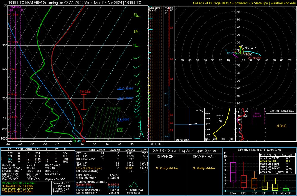
-
April 8th Eclipse- Last Easy One To See In My Lifetime
MN Transplant replied to Interstate's topic in Mid Atlantic
The OP GFS was trending well until 12z
-
April 8th Eclipse- Last Easy One To See In My Lifetime
MN Transplant replied to Interstate's topic in Mid Atlantic
Yeah, finding somewhere with bathroom access is key -
April 8th Eclipse- Last Easy One To See In My Lifetime
MN Transplant replied to Interstate's topic in Mid Atlantic
I’ve locked in NY, so now it is all about avoiding that leaf of citrus that will develop. I’m sure the roads between Syracuse/Watertown/Rochester will be easy to navigate on Monday -
I want severe graupel! .NEAR TERM /THROUGH TONIGHT/... Dry conditions have returned to the area early this morning, with some patchy dense fog developing in a few river valleys. Cloud cover increases this morning as a deep low pressure over the OH Valley moves east and over the area today into tonight. This is going to produce scattered to widespread showers, with isolated thunderstorms this afternoon into early evening. Given cold temps aloft, strong forcing for ascent, and steep mid-level lapse rates it is likely that the stronger convection produces graupel. Most of it should remain small, though it could accumulate in any heavy showers/storm. While it is not likely, cannot rule out that graupel reaches the size where a Severe Thunderstorm Warning could be needed. Highs today reach the 50s, and the upper 30s to 40s in the mountains.
-
Wonder if we’ll get some little hailers tomorrow with the upper low passing over. NAM has quite impressive mid-level lapse rates. edit - I see High Risk already mentioned this over in the severe thread
-
About an inch over the three days. Pretty boring.
-
April 8th Eclipse- Last Easy One To See In My Lifetime
MN Transplant replied to Interstate's topic in Mid Atlantic
Yeah, not great
-
April 8th Eclipse- Last Easy One To See In My Lifetime
MN Transplant replied to Interstate's topic in Mid Atlantic
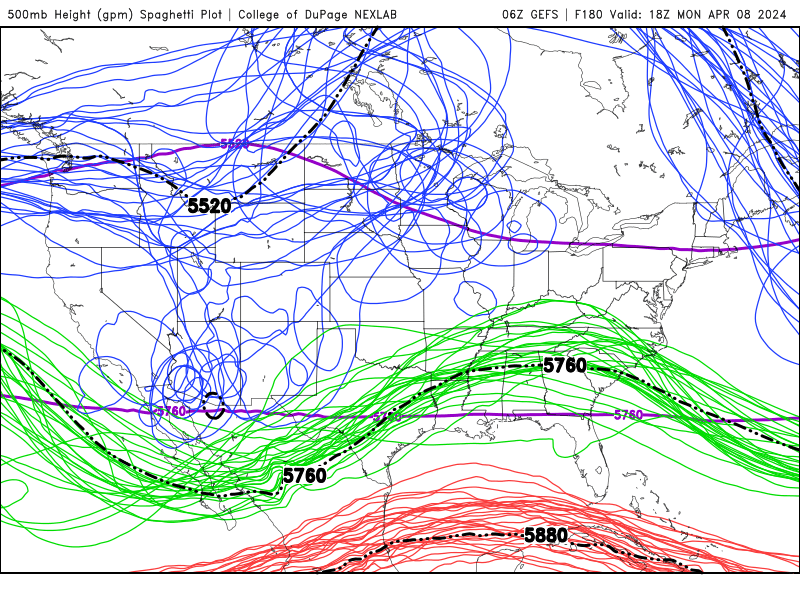
The OP GFS is the most aggressive in bringing the 500 low east, over Iowa on Monday. The Euro is way west, on the ND/MT border. The GEFS is over ND, with still some good spread in the ensemble members. West doesn’t “save” NY since there still may be a cirrus deck, but it is a lot better than the low going east where it brings lower clouds into play with precip nearby. -
April 8th Eclipse- Last Easy One To See In My Lifetime
MN Transplant replied to Interstate's topic in Mid Atlantic
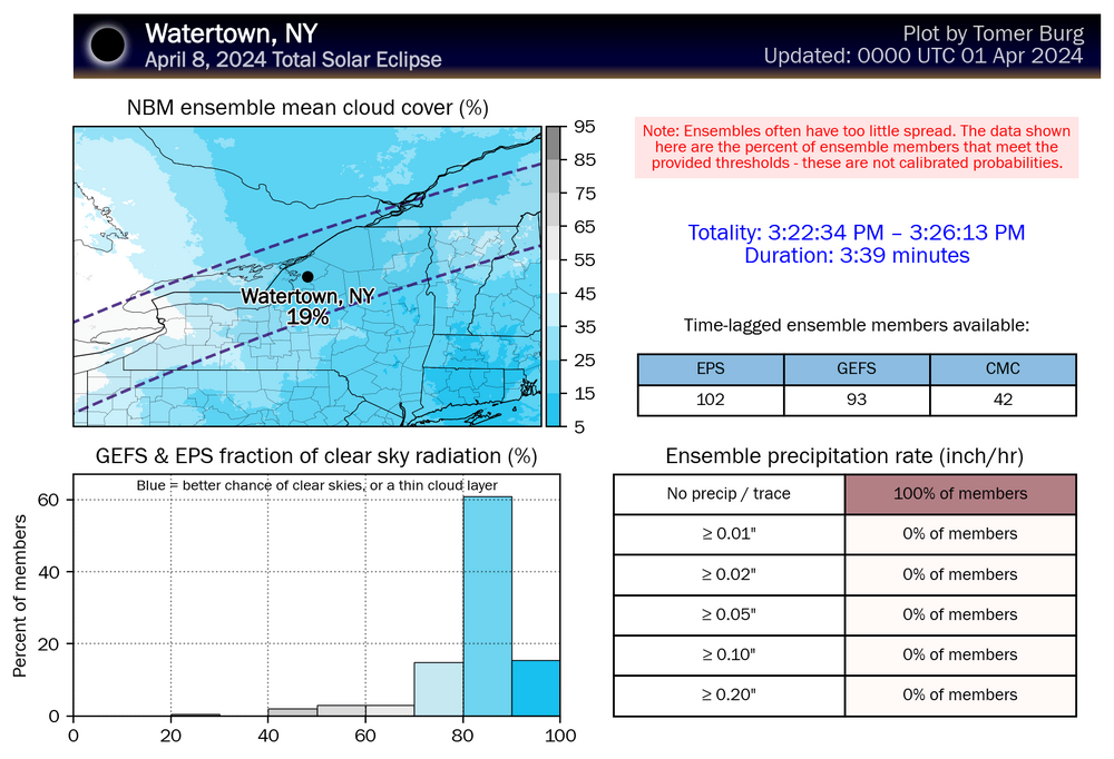
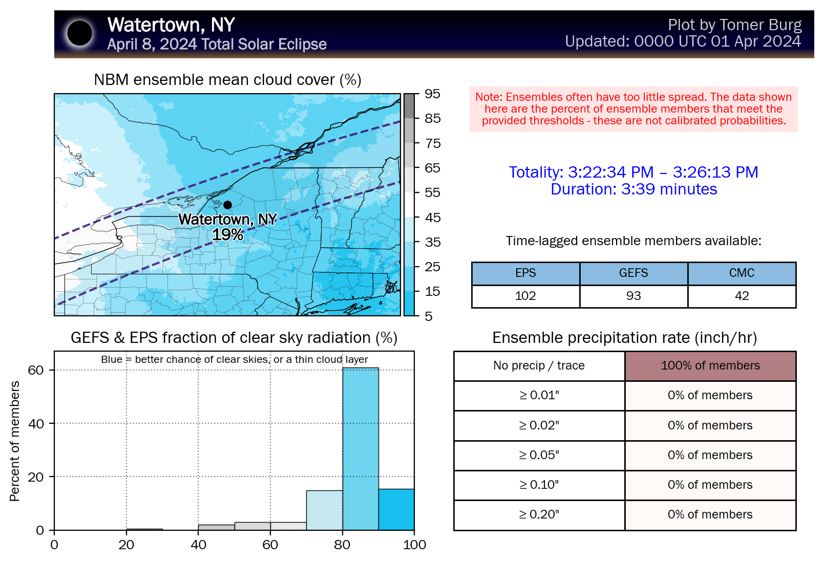
http://arctic.som.ou.edu/tburg/products/realtime/eclipse/ Looking pretty good in NY. The risk in the eastern US at this point is simply the location of the cirrus deck. I'm wondering if the best chances for Texas might simply be some clearing mid-day to allow the storms to fire in the afternoon (after the eclipse)..png.fd97f69269d6de4160632506b471ea72.png)
-
April 8th Eclipse- Last Easy One To See In My Lifetime
MN Transplant replied to Interstate's topic in Mid Atlantic
At this point the precipitation is just a proxy for cloud cover from the EPS. I do worry about the eastern areas having a leaf of high-level cloudiness come over. I hedged my bets last April and booked hotel rooms in both Louisville (with a target of Bloomington, IN or southern IL) and Syracuse. Worst case scenario for me is probably WxUSAF's best-case scenario, where the trough ends up clearing the Texas area, but is dousing the Ohio River Valley and cloudiness has spread over the rest of the northeastern US. -
April 8th Eclipse- Last Easy One To See In My Lifetime
MN Transplant replied to Interstate's topic in Mid Atlantic
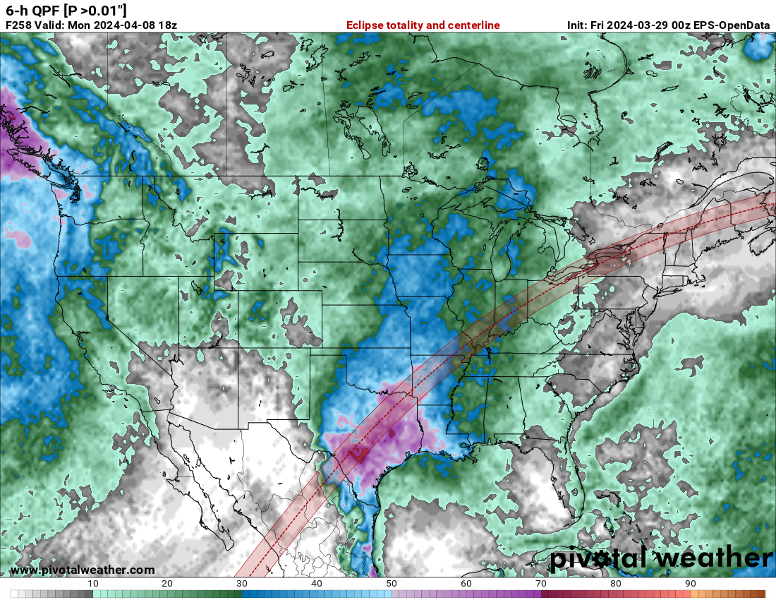
EPS from 00z and GEFS from 06z. Nice job by Pivotal of putting the eclipse path on their maps.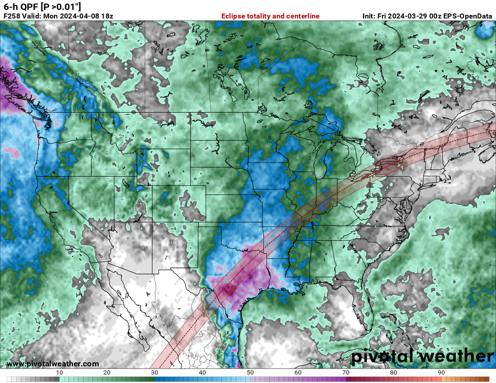
.thumb.png.e18d878fe475935d4ded40a8f72a01e6.png)
-
April 8th Eclipse- Last Easy One To See In My Lifetime
MN Transplant replied to Interstate's topic in Mid Atlantic
The GEFS has a convoluted set of solutions that indicate that anything beyond the 4th should be viewed very skeptically. There is a trough entering the lower 48 on the 4th. A fair number of the solutions dig the trough over the intermountain west, and then a following trough interacts with it and ejects it. Unfortunately, that is a pretty rotten result for much of the eclipse path. Hopefully it speeds up or slows down. -
Over 0.7” here. Sky is brightening.
-
Pretty gross day. I’d be fine if the slug of rain missed us east tomorrow.
-
I don’t think so. This isn’t like building a new bridge between MD/VA north of 495 or even expanding lanes on the Beltway. This is a replacement.
-
April 8th Eclipse- Last Easy One To See In My Lifetime
MN Transplant replied to Interstate's topic in Mid Atlantic
Tomer set up an eclipse ensemble page: http://arctic.som.ou.edu/tburg/products/realtime/eclipse/ -
https://twitter.com/forecaster25/status/1772066158725738506?s=20
-
April 8th Eclipse- Last Easy One To See In My Lifetime
MN Transplant replied to Interstate's topic in Mid Atlantic
Pretty good agreement now on the GEFS of a trough entering the west coast on March 31st and another following that on April 3rd/4th. The prior trough takes about 3 days to traverse the country, so the one on the 3rd/4th would theoretically be through the eastern US prior to the eclipse. That is absent any new blocking developing. However, the OP GFS is slower with the troughs and has the latter one entering the West Coast on the 4th and causing trouble for the Eastern US on Eclipse Day. -
April 8th Eclipse- Last Easy One To See In My Lifetime
MN Transplant replied to Interstate's topic in Mid Atlantic
Not worried yet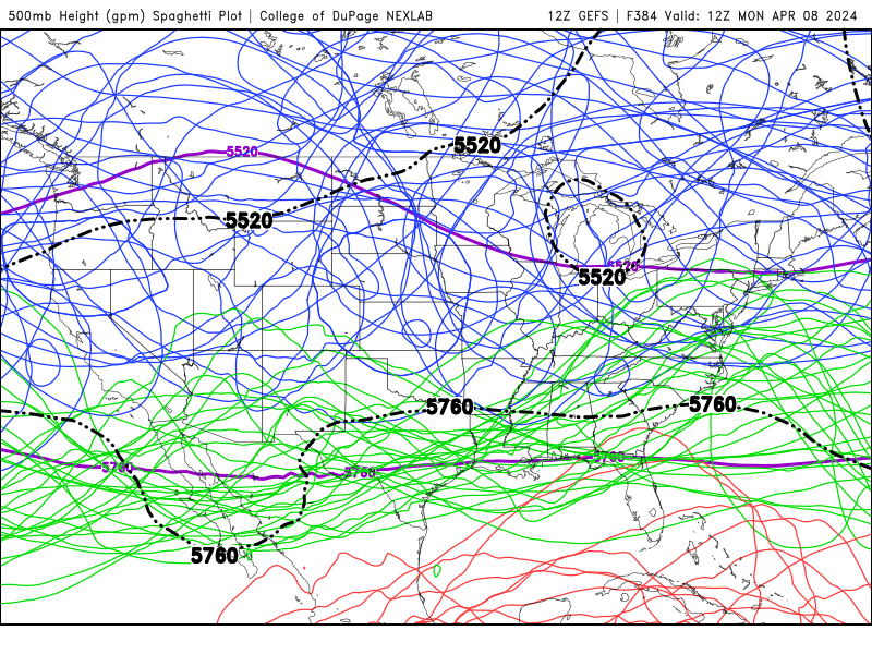
-
1.47" total


.png.cbeacacf03d54b092352e491310d0176.png)