

Dabuckeyes
-
Posts
246 -
Joined
-
Last visited
Content Type
Profiles
Blogs
Forums
American Weather
Media Demo
Store
Gallery
Posts posted by Dabuckeyes
-
-
1 minute ago, Kleimax said:
Isn’t the 3k superior to the 12k? 3k not nearly as good for us.
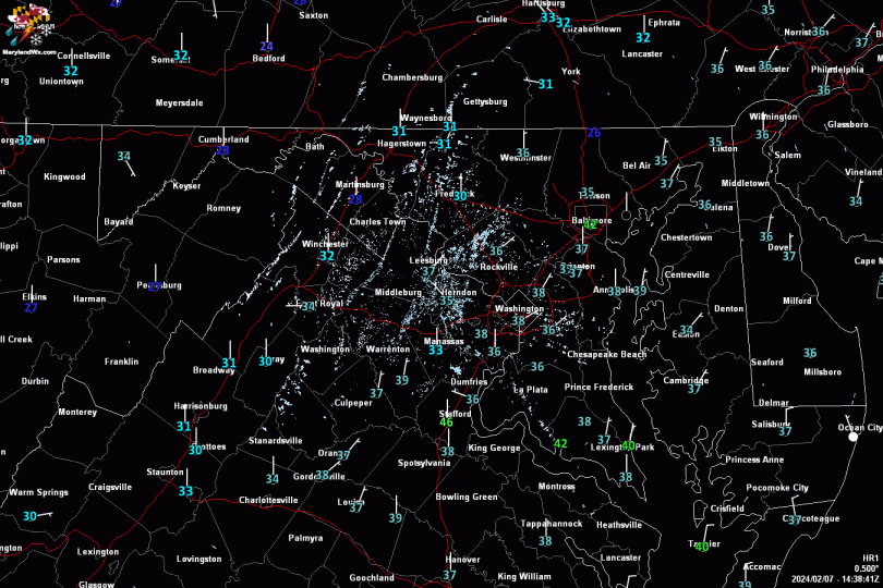
Correct me if I'm wrong, but the 3K is higher resolution. It is razor close along the fall line with surface and 850 temps. A very small adjustment would make a big difference in snow vs. sleet totals.
-
1 minute ago, Ji said:
im going to assume this is also snow

And this...

-
 2
2
-
-

Compared to 12z:

-
There's a shift south with the low pressure on the 18z NAM. Has an effect for the northern regions staying frozen.
-
I understand the snow totals have been dwindling away over the past few model cycles. However, are we still looking at a decent sleet event in the Baltimore Metro? Seems temperatures are hovering at freezing and the 850's are near that as well. I understand things can shift or change, but as it stands with most model guidance.
-
If we are looking for slight improvements, the high seems to be slightly stronger this run of the NAM.
-
20 minutes ago, WxUSAF said:
WBAL riding RPM which says 10”+ for areas north of DC-BWI...


I’ve always thought that model was more on the conservative side. Interesting to say the least.
-

Here's the 10:1 snowmap from pivotal. More "frozen" near the 95 corridor.
-
I think everyone could use Yoda coming in here with an upside down UKMET map telling us it will all be okay
-
1
-
 6
6
-
-
CMC running a tight line right down I-95. Temps in the cities are just below freezing with heavy precip. Could be a sleet bomb in the making.
-
1
-
-
Just now, BTRWx's Thanks Giving said:
Why do people still look at the model that is supposed to be retired?
Should be planning lessons, but killing time before my next class instead
-
1
-
-
The usual caveats with a NAM at 57, but it is slightly colder at the surface in the cities this run. Low is still in the same general area as last few runs.
-
Quite a band of heavy rain moving through central Maryland. What could have been if it were just a few degrees colder.
-
5 minutes ago, losetoa6 said:
Icon is colder . That's the takeaway that matters
")
Probably because the energy is on land now
")
-
1 hour ago, leesburg 04 said:
Oh lord which Kirk Cousins will we get
Based on the 12z mesoscale models He’s already thrown two picks
-
2
-
-
27 minutes ago, LeesburgWx said:
Who wants snow Monday if we can get 18 inches Wednesday
I'll sacrifice the good for the great
-
 1
1
-
-
It would be nice to see some consistency with the Euro. It went from no storm yesterday at 12z to a decent coastal at 0z. I understand it is out there in time and there are many moving parts. Guess we will find out in a few minutes.
-
Without being able to turn up the coast, this looks like a Roanoke to Richmond special.
-
10 minutes ago, losetoa6 said:
I'm starting to get interested in the day 5/6 timeframe.
Is there a follow up storm?
-
First burst of sunshine in Timonium
-
41 minutes ago, WinterWxLuvr said:
A further east track would do wonders. That track to me still looks suspect. It’s not a common one in the winter.
I mean, atmospheric memory will save us....right??
-
BWI: 10/30
RIC: 11/5
IAD: 10/28
DCA: 11/2
Tie: 82F
-
First line was a 5 minute gusty shower. Let’s see if anything comes from this line.
-
8 minutes ago, H2O said:
Come south!!!! Thats all I ask for!!!
The line does seem to be moving more east than south.
December 16-17, 2020 Winter Storm Obs/Nowcasting
in Mid Atlantic
Posted
I agree. As is, the 3K is snow to sleet back to snow for the Towson area. I could see a couple of inches of snow followed by 2-3 inches of sleet if that were to play out.