

Snownado
-
Posts
440 -
Joined
-
Last visited
Content Type
Profiles
Blogs
Forums
American Weather
Media Demo
Store
Gallery
Posts posted by Snownado
-
-
40 minutes ago, Hoosier said:
The answer is yes. 100 at Cairo. And don't give me the bs about 37.7C being 99.9F
KCIR 132055Z AUTO 26009G15KT 10SM CLR 38/22 A2987 RMK AO2 T03770219
I'm not even sure Cairo is considered East of the MS River.Part of the MS River is East of Cairo and part of it is West.
-
3 hours ago, Hoosier said:
70+ dewpoints have made it into Iowa.
Dewpoints in the 50s in Northern Florida and 70s in Iowa. How is that possible ?
-
 1
1
-
-
3 hours ago, weatherbo said:
Like many of you it's snowing again this morning. Probably will reach 2 inches before it changes over to light rain, then back to snow this evening where a light northerly upslope component could add another 2 or so inches (or several if the ARW and NSSL are to be believed). I've received 14 inches nickel-n-diming it this month which is really close to the average for April up this way. Yesterday was gorgeous with light wind, sunny skies and a high temp of 37. Was outside all day.
A few more days of the coolness then hopefully more seasonable temps will arrive and stay.
Wow. 37 in Mid April sounds brutal. I'm guessing thats well below normal ?
-
1
-
-
4 hours ago, weatherbo said:
Vigorous Springtime snow showers all day. Near 1/4 mile visibility one minute then sunshine the next then back to snow.
Still SO MUCH snow otg!
Is it safe to say you will still have snow on the ground in June ?
-
On 3/18/2022 at 1:27 PM, Carvers Gap said:
12z GFS has two opportunities. One is around the 27th, and then the one you mentioned. And yes, the GFS has had a real knack for sniffing out storms at range.
@Icy Hot, yep, enjoying the weather and watching A LOT of basketball.
It's going to be 74 in Johnson City on the 29th according to TWC. Going to have to be a lot colder than that for it to snow !
-
6 minutes ago, Shocker0 said:
The low temp was about 2am, so actually it happened closer to 10 hours ago. When I got up around 6am it was already up to 15, probably from when the clouds started rolling in. Now it's completely sunny again. Seems pretty possible to me. Mayland near me is reporting 35 right now as well and was 10 last night. I figured my station was off on temps but it looked similar to other nearby stations overnight. I was just going off what my station said. Snow cover + clear skies can cause the temperatures to plummet pretty quickly and then rise again as cloud cover moves in and wind shifts from the south.

Is your snow melting pretty fast?
-
8 minutes ago, Shocker0 said:
My station bottomed out at 5 last night NW of Crossville, but is already up to 35 today. It may be somewhat accurate because I did see a station 15 miles east reporting 5 degrees, and another 7. It seemed to melt more yesterday than today so far, but we've also had cloud cover today.
Winter wasn't great in Knoxville this year but I have to think going out with such a bang like that makes it jump way up. If this storm happened in November or December and the rest of the winter was lackluster, it'd feel a lot more disappointing I would imagine

There's no freakin way it went from 5 to 35 in just 4 hours especially since you say you have cloud cover ?
-
21 minutes ago, Carvers Gap said:
This is easily our best storm of the season in west Kingsport. Probably between 4.5-5" of snow here at the house and a solid 5" of snow on the groomed surfaces of the golf course. Sledding is good today. I have almost enjoyed these snow bands as much as the storm itself. Going to be COLD tonight!!!
I bet most of your snow will be gone by tomorrow evening.
-
1
-
-
4 minutes ago, John1122 said:
The fine powder is high ratio and it piles up fast. I had 11 inches in 3 hours during the blizzard and flakes were dime sized. There were just so many of them falling it was like a fog cloud on the ground. Similar conditions now. The blizzard lasted for almost 24 hours, this one is going to last 5 or 6 or we would be looking at 2 feet.
Which blizzard are you referring to ?
-
10 minutes ago, TellicoWx said:
Folks already giving Little Rock mets a rough time on social media lol...posting pics measuring 2"-3" saying "yep, looks like a dusting"
My uncle who lives in the UP of Michigan considers 2-3" a dusting.
-
3
-
 3
3
-
-
1 hour ago, weatherbo said:
MQT(Negaunee) averages 29.4 in March and 17.6 in April, not sure where the 22 inches is from.
I'm roughly a half hour nw of Marquette the city.
According to wikipedia, Marquette averages 14.2" in March and 8.4" in April. It says the source is NOAA.
-
1 hour ago, weatherbo said:
High of 24 here today with a little over 2 inches of snow. Off and on light snow chances and well below freezing temps for the rest of the week.
After the 40 inches of snow last week, a more tranquil pattern has been welcome. Spent the past few days moving snow. I did end up taking a good deal of snow off the roof. Heading into March, systems can become much wetter and I was concerned about the potential for a cold rain or heavy/wet snow event that the roof snow would just soak up rather than shed. On average there is still another 50 inches of snow here... better safe.
That's crazy that you have another 50" left to go on average. Marquette only has another 22" left on average. How far from Marquette are you ?
-
I personally like March more than February. In March, warm days are much more common and the weather can be more interesting too with anything from snow to very warm weather. I've seen temps near 90 in March ! I also love the longer days.
-
56 minutes ago, HighTechEE said:
I-70 special 16 days out: 06z GFS almost 2ft, lock it in, LOL
Sun angle might be an issue.
-
3
-
-
2 hours ago, beavis1729 said:
Yeah...and INL dropped to -40 again...breaking yesterday's record for the coldest temp so late in the season.
Reminds me of the early Feb 1996 arctic outbreak, where the nights in northern MN were brutally cold but it warmed up quite a bit during the day. An even deeper snowpack back then (generally 30-40"), plus not as late in the season, plus the airmasses themselves were a bit colder. Some areas saw several nights of lows in the -40s to -50s.
A low of -40 and high of 15 is impressive. 55 degree increase from morning to afternoon.
-
6 minutes ago, Frog Town said:
or 4 weeks...but who's counting.
Officially meteorological spring begins next week.
-
2 minutes ago, Hoosier said:
Much has been made about the poor GFS performance with it consistently being too far north (not to mention super inflated totals) but it actually overcorrected south toward the end with the placement of the main band. Here's the 00z Feb 17 run, just hours before the snow started.
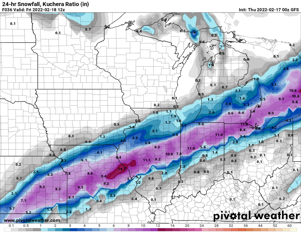
11" in Fort Wayne ? I think they got about 3" lol.
-
 1
1
-
-
8 minutes ago, OrdIowPitMsp said:
Low of -2 in Minneapolis this morning. Much colder outside the urban core.
Looks like at least 6 or 7 more sub zero mornings for you in the next 2 weeks.
-
1
-
-
4 minutes ago, SolidIcewx said:
Not quite sure why they have little impacts from Fort Wayne up through DTW. Based off everything I’d say Major impacts especially in the Detroit metro with it being rush hour and later

Obviously they are not expecting much if any accumulating snow in Ft Wayne. Otherwise the impact would be much higher.
-
1 minute ago, michsnowfreak said:
Howling south winds, 46, and the snowpack still holding.
Good grief. What's it gonna take to melt the snowpack ?
-
2 minutes ago, StormChaser4Life said:
Man nw trend is not being denied this time. If it keeps up I will stay all ice or end up getting all rain. Was kind of looking forward to a wind swept snow since last snowstorm was pretty windless. Hoping this can correct south a little. I'm right on the southern edge of the heaviest swath.
I wonder if it's because we are late in the winter. Are late winter storms more likely to trend northwest ?
-
53 minutes ago, Frog Town said:
Definitely not us. We are not normal. Normal people still rely on the 6 o'clock news...
I think normal people get their weather from an app on their phone.
-
1
-
-
Most of us live closer to the Equator than the North Pole. Summer SHOULD be longer than winter, but for some reason winter likes to drag on sometimes.
-
16 minutes ago, TARHEELPROGRAMMER88 said:
Spring is coming
Yeah in May.
-
 1
1
-
 3
3
-

The 2022 Summer Solstice-ish Scorcher(s)
in Lakes/Ohio Valley
Posted
I wonder why Minneapolis was 101 today and Rochester was only 96 ?