

Dalfy
-
Posts
481 -
Joined
-
Last visited
Content Type
Profiles
Blogs
Forums
American Weather
Media Demo
Store
Gallery
Posts posted by Dalfy
-
-
Here's the LSX AFD for those in eastern MO and west central iL.
FXUS63 KLSX 132351
AFDLSX

Area Forecast Discussion...Updated Aviation
National Weather Service Saint Louis MO
551 PM CST Thu Jan 13 2022

.SHORT TERM... (Through Saturday Night)
Issued at 259 PM CST Thu Jan 13 2022

...Winter Storm on track for Friday Afternoon-Saturday...

It`s currently the calm before the storm across the CWA with lots
of sun and above normal temps. The pockets of light rain across
parts of eastern MO and western IL exited by early afternoon with
clouds clearing quickly. This evening looks pretty tranquil with
colder air filtering into the region as high pressure settles
southeastward. Much of the latest guidance is showing a fairly
strong signal for low stratus and fog developing overnight from
central IL west-southwestward into western IL and parts of eastern
MO. In fact some of the guidance suggests that the fog could be
dense in the 10-15z time frame. I am not that confident in the
dense fog aspect but it is something we will have to watch. The
remainder of Friday morning should be rather tranquil with clouds
thickening ahead of the winter storm.

All systems still appear go for a winter storm impacting the area
starting Friday afternoon and lasting possibly into early Saturday
evening. This will be the first real widespread snowfall impacting
the entire CWA. There are still some questions on amounts and onset
times but the majority of the guidance suggest that snow will
develop sometime in the afternoon across Northwest Missouri and
west central IL in response to isentropic lift, weak large scale
forcing, and impressive mid level frontogenetic forcing. This
should lead to a rather robust and wide band of snow driven
strongly by frontogenesis. The band should then widen and
translate slowly south-southeastward on Friday Night and into
Saturday morning as both the frontogenesis and large scale forcing
attendant with the upper trof/low centered in the Plains digs
southeastward. The mid level lapse rates are 6+ DegC/km
suggesting a good response to the frontogenetic forcing and
supporting snowfall rates in excess of a half inch per hour at
times.

While there could be some brief rain at the onset of snow for areas
from central MO into southwest IL and points south, I still think
that this should be brief with low levels cooling rather quickly.
This will be a fairly wet snow with lower than normal SLRs. The
longevity of the snow in the north and intensity of the forcing
still highlights this region for the highest amounts. The WPC
forecasts, HREF, and probabilistic guidance all support this area
having potential for 6+ inches. We have decided to issue a winter
storm watch for this area starting on Friday afternoon. For the
remainder of the area this looks like a pretty solid 2-5 inch
snowfall and will eventually lead to an advisory within the next
12-18 hours.

There has been some concern about a period of heavy snowfall late
Saturday afternoon/night into early Sunday morning across southeast
MO/southern IL associated with the upper low and deepening cyclone
as it tracks to our south. The trend in the latest ensemble and
deterministic models now has the upper low digging longer and to
the east of the track yesterday, and not bottoming out until
Saturday night well south across the lower MS Valley and then
shifting east across the deep south. This track would suggest this
snow threat then will be well south of the CWA.

Glass
-
A really satisfying trace fell, that's all I needed to enjoy my late spring walk haha. Looks great on the flowers and trees. Temp is 34.
-
All snow in STL, 4 hours ahead of schedule with the changeover lol. Temp is 35.
-
 1
1
-
-
1 hour ago, Hoosier said:
Maybe the Ukie will never shift north.
This is 10:1 because that is all that is available

Or fill in around south central illinois. Reminds me of the classic DC snow hole
-
GFS continues its tease
-
Time sensitive:
-
1
-
-
Laramie WY webcam:
-
2
-
-
STL had a pretty intense band set up about an hr ago - ~25-30dbz. We're back down to light snow.

Our AFD mentions up to an inch in our metro associated with the area of lift. [on an unrelated note: I'm really trying to expand my knowledge of some of these terms they use in the AFD - frontogenesis, isentropic lift. I'm not in any math heavy fields, and I looked through the weather 101 forum without much avail to find a conceptually-focused guides that could help me interpret better. If anyone has any good, beginner-friendly sources I'm all ears and open hands]
-
1
-
-
Very nice discussion by STL crew regarding the final days of the arctic air mass:
.LONG TERM... (Thursday through Monday)
Issued at 426 AM CST Tue Feb 16 2021

Deterministic guidance is now in good agreement for Thursday.  Where
in past runs there were a range of solutions, some producing another
significant snow storm for the area, the latest GFS and ECMWF both
keep the entire area dry on Thursday as the trough aloft continues
to dig into the Gulf of Mexico, resulting in low level cyclogenesis
along the coast.  The Mid Mississippi Valley is too far back into
the cold/dry Arctic air on Thursday.  Even the GEFS >0.01 QPF
probability map has only 10-20% over our far southern counties, and
the more likely chances down across the Bootheel.  I did leave some
token slight chance PoPs in for parts of the area on Thursday to
cover those very low chances in the ensemble, but if the trend
continues we`ll be able to pull those by this afternoon.

The remainder of the forecast will be characterized by a warming
trend into the weekend and early next week as the upper level
pattern shifts.  The persistent eddy in the northern stream that`s
been hanging over the CONUS and keeping us locked in such a cold
surface pattern over the past week will finally fill in and move
east.  This pattern shift will finally shut the door to the Arctic
which had been left standing open since February 6th and
temperatures will begin warming back toward normal.  The snow
pack will slow our moderation down somewhat, and it`s unlikely
highs will get above freezing until at least Saturday.  However, by
Monday it could be a balmy mid to upper 40s across the area.

Carney
-
^LOL, I can imagine after what you guys have been through.
-
6-7'' reports in STL city, our local office was spot on. Really enjoyed this storm!
-
7 minutes ago, Chicago Storm said:
Cook Co crusher...

.Chicago is gone... lmao: https://www.earthcam.com/usa/illinois/chicago/field/?cam=fieldmuseum

-
So incredible outside. It hasn't been since, maybe 2016 that I've had the chance to walk through rates as intense as this. Visibility still very low here-maybe a few blocks worth, with a very fine-grain +SN [wind is hard to gauge since I'm deep in the city]. Temp is 3 degrees. Not sure how much we've accumulated since it's all drifted around.
-
5 minutes ago, Chicago WX said:
STL cooking with gas
KSTL 151851Z 34010G21KT 1/2SM R30R/1600V2200FT SN VV007 M16/M19 A3022 RMK AO2 SLP258 SNINCR 1/4 P0004 T11611194
Yessir. Sounds about right
-
Glass from STL, really interesting disco:
Light snow with pockets of moderate snow cover the majority of
the CWA early this morning. This snow is occurring in response to
a broad region of mid level frontogenetic forcing and weak
isentropic upglide, with a little added help from a weak vort max
moving across MO at this time. Light snow wavering in intensity is
expected to persist through mid-morning and could briefly end in
some areas. The ongoing winter storm will really get going after
around 15z with the greatest overall intensity centered on this
afternoon. Guidance is all in good agreement showing a classical
evolution per conceptual models as the upper trof currently over
the southern Plains ejects northeastward and becomes negatively
tilted, leading to a deepening surface low tracking from the
north- central GOM through the TN Valley. Strong large scale
forcing associated with the upper trof, stout mid-level
frontogenetic forcing associated with a cyclonically turning
branch of the warm conveyor belt, and coupled ULJs will lead to
robust ascent across southeast and east central MO into west
central IL. This strong ascent within a deep dendritic growth zone
will result in high snowfall rates and heavy snow during the
aforementioned time frame. The HREF, HRRR, and RAP all are showing
snowfall rates at times of 1+ in/hr. I`m in new territory
estimating the SLRs as never in my 30+ years forecasting have I
dealt with a major storm with this cold of an airmass. I am using
20:1 or greater and they increase with time. This results in
additional snowfall from 600 am today through midnight of 5-9
inches within the winter storm warning area, the highest amounts
along an axis from near Fredericktown to Salem IL. This corridor
is good agreement with well established techniques from
climatologies by Goree & Younkin, Browne & Younkin, and Gosselin
using the track of the 850 mb low center. The model consensus of
this 850 mb low track is from central AR skirting the bootheel to
just north of Louisville. Gusty winds with the tightening pressure
gradient and the light fluffy nature of the snow will bring
concerns for blowing and drifting. To top this off we remain in
the throes of bitterly cold air and dangerous wind chills. Travel
is not recommended. If you become stranded it could result in a
life-threatening situation. Outside of the warning area, a solid
2-5 inch snowfall looks in order. The current winter storm warning
and advisory look on target. The storm system should completely
exit and area by 06-09z with bitterly cold air and dangerous wind
chills continuing into Tuesday morning. A few record lows may be
possible Tuesday morning and the record low maxes today will again
be shattered. The wind chill warning and advisory in effect until
noon Tuesday looks good as well.

Tuesday is still looking like a down day with weak surface high
pressure dominating. Very cold temperatures will continue. There
could be some flurries around in the morning due to lingering
stratus.

Glass
-
1
-
-
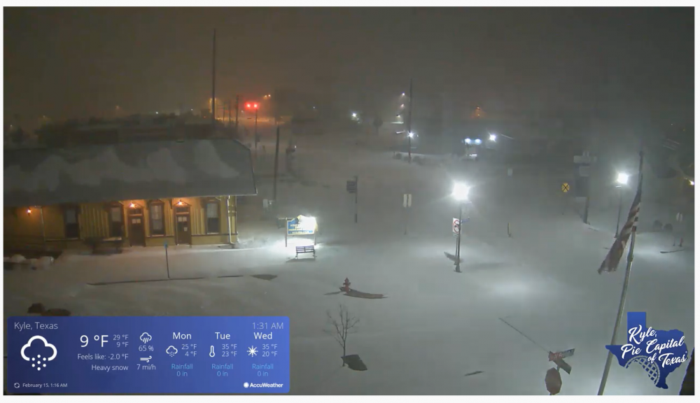
Webcam just south of Austin, TX [1:33AM CST]. Incredible:
-
3
-
-
14 minutes ago, WeatherMonger said:
Can you make my call as well?

Only thing out of ILX on Facebook is about the cold. Someone asked them about higher totals, sais LSX had mentioned it but they did not respond.
Went to LSX page and seen this. Cautiously optimistic, yet knowing howbthings usually pan out keeps me a bit pessimistic.

Nice! Looking like they'll upgrade us soon.
EDIT: just happened: 6-9'' call STL metro
-
54 minutes ago, Dalfy said:
STL's criteria is >=6 inches I believe. They haven't updated their AFD or forecast since this morning at 6, before the NW shift; they were calling 4-6'' which is under their warning criteria.
"Other potential areas for concern with this forecast are exactly
what the SLRs will be and whether we might be a tad low on snowfall
for Monday. Given the very cold air mass, snow ratios should be high
with dendrites dominating. Present thinking is that storm total snowfall
amounts will range from 2-3 inches in far northeast MO and west
central IL to 4-6 inches encompassing the remainder of the CWA.
These totals agree well with GEFS exceedance guidance using a max
SLR, and are in the 50-90th percentile of the NBM. Noteworthy is
our operational NBM data looked a bit light on QPF for Monday. The
winter weather advisory looks on target for this event considering
the aforementioned expectations and has been expanded to include
the remainder of the northern CWA."
Glass from STL CWA, stuck to his guns in the 1pm update. It's also interesting they're the only CWA to not expand wind chill warnings south of the central portion of their forecast area.
Other potential areas for concern with this forecast are exactly
what the SLRs will be and whether we might be a tad low on snowfall
for Monday. Given the very cold air mass, snow ratios should be high
with dendrites dominating. Present thinking is that storm total snowfall
amounts will range from 2-3 inches in far northeast MO and west
central IL to 4-6 inches encompassing the remainder of the CWA.
These totals agree well with GEFS exceedance guidance using a max
SLR, and are in the 50-90th percentile of the NBM. Noteworthy is
our operational NBM data looked a bit light on QPF for Monday. The
winter weather advisory looks on target for this event considering
the aforementioned expectations and has been expanded to include
the remainder of the northern CWA.
-
6 minutes ago, Snownado said:
I don't understand why the warnings are so far north along the IN/IL border on the IN side but drop much further south on the IL side. Can anyone explain ?
STL's criteria is >=6 inches I believe. They haven't updated their AFD or forecast since this morning at 6, before the NW shift; they were calling 4-6'' which is under their warning criteria.
"Other potential areas for concern with this forecast are exactly
what the SLRs will be and whether we might be a tad low on snowfall
for Monday. Given the very cold air mass, snow ratios should be high
with dendrites dominating. Present thinking is that storm total snowfall
amounts will range from 2-3 inches in far northeast MO and west
central IL to 4-6 inches encompassing the remainder of the CWA.
These totals agree well with GEFS exceedance guidance using a max
SLR, and are in the 50-90th percentile of the NBM. Noteworthy is
our operational NBM data looked a bit light on QPF for Monday. The
winter weather advisory looks on target for this event considering
the aforementioned expectations and has been expanded to include
the remainder of the northern CWA."
-
2 hours ago, Air Traffic Control said:
I heard the cry for lurkers to appear...
Lurker from about an hour east of the St. Louis city, and seeing that bright pink bulls eye moving slowly to my location is... Well, as a person who grew up in an island with snow a foreign word [or the precursor to the apocalypse], the amount of hype I'm feeling is beyond ecstatic!!
We still have graupel from last week hanging around - radiant heat has turned the top layer to ice, but it's still majestic to see. About 2" or so - the air not being above freezing since the 5th or so ofFeb helps. Was also a brutal -1°F, too, this morning. I've never been so cold before in my life...
Our AFD from yesterday:
"As the main surface system passes south and east of the CWA overnight Sunday into Monday, the probability of accumulating snow ramps up mainly along and south of the I-70 corridor. Upper-level divergence from the trough and mid-level frontogenesis will couple with cold air to produce efficient snow-to-liquid ratios. By the time this system departs the CWA Monday afternoon and evening, snowfall will range from 2-5 inches along and south of the I-70 corridor. I continue to have confidence in these totals, as blended and ensemble guidance continue to focus the greatest snow potential and amounts along this corridor."
Learning moment: never have significant confidence in models >48 hours out, lol.
-
 1
1
-
-
STL's AFD. They feel confident w/ call for 2-5'' along and south of I70 within their CWA
QuoteThe other threat we`re focused on is the accumulating snow starting across portions of central Missouri Sunday morning and continuing through Monday evening. Here, an upper-level trough will eject out of the southwestern U.S. and push eastward. A leading impulse within this trough will spark precipitation late Sunday morning across portions of central Missouri. Higher probability of snow will spread eastward, primarily across portions of northeastern Missouri and west-central Illinois through the day. Snowfall within this first round will be around an inch or less mainly focused in central and northeastern Missouri through west-central Illinois. As the main surface system passes south and east of the CWA overnight Sunday into Monday, the probability of accumulating snow ramps up mainly along and south of the I-70 corridor. Upper-level divergence from the trough and mid-level frontogenesis will couple with cold air to produce efficient snow-to-liquid ratios. By the time this system departs the CWA Monday afternoon and evening, snowfall will range from 2-5 inches along and south of the I-70 corridor. I continue to have confidence in these totals, as blended and ensemble guidance continue to focus the greatest snow potential and amounts along this corridor. Elmore
-
STL's AFD
Quote.LONG TERM... (Sunday through Friday) Issued at 419 AM CST Sat Feb 13 2021 The screaming message from last night has not changed 24 hours later with bitterly cold air/record temperatures, dangerously cold wind chills, and accumulating snowfall the highlights into next week. Record low max temperatures Sunday into Monday still look like a slam dunk, however I have less confidence in record low temperatures due to persistent cloud cover. Still generally all but southeast MO and far southwest IL will have mins below zero through Monday and the entire CWA may have mins below zero on Tuesday morning. The increasingly active upper air pattern starting later this weekend and continuing into next week will bring accumulating snowfall to the region first Sunday into Monday. This first event will come in two waves. On Sunday the consensus is the first wave will be focused from central MO into west central IL associated with a weak impulse in the southwest flow aloft and attendant mid level frontogenetic forcing. Snowfall amounts with this wave generally look light, around an inch or less. The more substantial snowfall will occur with the second wave centered on Sunday night and Monday. The best focus for this snowfall will centered along and south of I- 70 associated with increasing low-mid level frontogenetic forcing and increasing large scale forcing occurring ahead of a migrating upper trof. Until late Monday the models lack a coherent 850 mb low which could offer even greater snowfall potential. However this combination of persistent frontogenetical forcing and large scale support with the trof, and very cold temperatures yielding high snow ratios, should still produce a solid measurable snowfall of 2-5 inches across much of the CWA with the highest amounts along and south of I-70 in the 4-5 inch range. The NBM and GEFS exceedance probabilities support this region for the highest snowfalls with good support for 4+ inches. If the amounts stay in these ranges then this would be an advisory level event, and those headlines would likely becoming later today. We are still eyeing another system in the Wednesday-Thursday time frame. There are some rather significant differences in the models with regards to the depth and speed of this next migratory upper trof, with some solutions indicating possibly a light snow and others a rather classic winter storm. Like last night, confidence in the specifics remains low. The very cold, well below normal temperatures will continue mid-late week. Glass
-
3 minutes ago, NwWhiteOut said:
Lmao, I been seeing these memes everywhere. Im rolling here lol
LOL, I'm glad you appreciate the humor.
-
1
-
-


Jan 14-15th Hybrid Winter Storm
in Lakes/Ohio Valley
Posted
0z Nam and other short term guidance has been keeping surface and lower levels warmer in St. Louis area compared to previous runs. I'd like to see what other runs show but I'm worried about the assumption of quick cooling in this area.