

Dalfy
-
Posts
481 -
Joined
-
Last visited
Content Type
Profiles
Blogs
Forums
American Weather
Media Demo
Store
Gallery
Posts posted by Dalfy
-
-
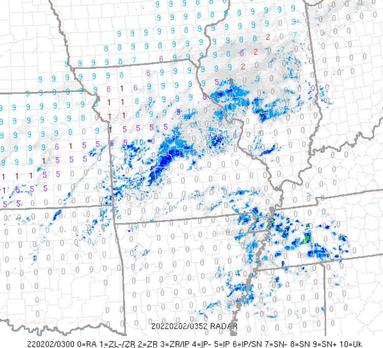
First flakes just starting to fall in the STL metro area. It's incredible to see the precip shield of the two waves on one map, there's rain and snow falling from the US-mex border all the way to maine.
-
 1
1
-
-
Radar looks so juicy
-
Second wave at LSX's doorstep, hoping for 4-8''to pad the 2'' from this morning.
-
2
-
-
We're officially all snow, at 12z, ~4-8 hours earlier than short term guidance forecasted [RGEM, RAP, HRRR] up until 1 or 2 last night. I'm really looking forward to the afd as they also went with short term in suggesting changeover would occur sometime in mid morning through early afternoon.
-
1
-
-
17 minutes ago, Dalfy said:
Wow, I looked outside and it's currently sleet/snow with trace accumulation on grass. Temp is 31.
Here's a webcam from near forest park in St. Louis for those interested: https://fox2now.com/webcams/chess-club-hall-of-fame-in-the-central-west-end/
-
Wow, I looked outside and it's currently sleet/snow with trace accumulation on grass. Temp is 31.
-
30 with snow/rain mix in STL
-
9 minutes ago, Hoosier said:
Changeover taking a little longer to happen than most models indicated around here.
Don't take my word for it but I think it'll be in the next 2-3 hours max. Current wetbulb temps; check the time trend on spc:
-
Maples' rough estimate of changeover- Jefferson, MO and metro. 1-4am sounds right and earlier than Canadian guidance by 10-12 critical hours. I don't think I'll be able to sleep monitoring this haha:
.AVIATION... (For the 06z TAFs through 06z Wednesday Night) Issued at 1040 PM CST Tue Feb 1 2022 A high impact winter storm is imminent with a broad area of precipitation stretching from central Illinois southwestward through a large portion Missouri. Rain transitioned to all snow at KUIN around 02z this evening with the transition affecting KCOU between 03z and 04z. Following shortly behind will be KJEF around the release of this update. Metro terminals will likely follow between 07z and 10z. -
For those in LSX:
000
FXUS63 KLSX 020254
AFDLSX

Area Forecast Discussion...Updated
National Weather Service Saint Louis MO
854 PM CST Tue Feb 1 2022

.UPDATE...
Issued at 830 PM CST Tue Feb 1 2022

A broad area of precipitation stretches from interior sections of
central Illinois to southwest Missouri this evening. Coverage and
arrival time of the precipitation is in good agreement with
expectations so far.

Automated surface observations show sub-freezing air making
progress into portions of northeast Missouri and west-central
Illinois. Rain transitioned to a brief period of freezing
rain/sleet around Quincy before changing to all snow around the
02z hour. Reports of all snow in Hannibal also provide ground
truth to the advancing cold air.

What has been evident over the last 3-4 hours is that the cold air
has run about 20-25 miles further southeast than hourly forecast
trends previously depicted. Updates have been made to reflect this
trend with the potential that FZRA/PL could be 1-2 hours ahead of
schedule, should this trend win out. The only question remains
the warm nose aloft and how long it holds/erodes tonight into the
morning period. This trend will need to be monitored through the
night, as any deviation will have the greatest impact on
accumulations near the transition zone (southeast MO/southwest
IL).

Maples

&&
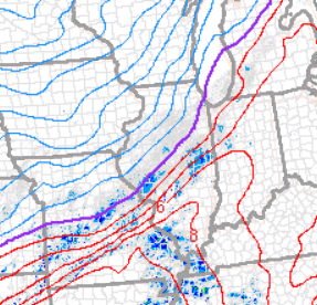
Current rain snow line:
-
2 minutes ago, Powerball said:
21z RAP was slightly NW with the 2nd wave.
16'' downtown STL lol, crazy.
-
It seems MBY continues to be at a real battleground with respect to warm layer. 18z RGEM and 12z GGEM maintain warm layer aloft well into Thursday which keeps us mixed for most of the event; NAM, EURO, GFS have trended toward warm layer cooling by late Wednesday night/00z Thursday which keeps us snow for precip thrust from the main low which is resulting in these boosted forecast totals. I'm liking my chances especially given the new 00z guidance, we'll see how RGEM and GGEM trend tonight. EDIT: RGEM came in slightly cooler, with changeover around 6z Thursday.
-
24 minutes ago, Chambana said:
12z euro crushes E Central Illinois and Central Indiana.
oops a little behind didn’t see the posts above me pertaining to it.
ILX is going to get shellacked. It seems like track is relatively consistent, I'm just hoping the warm nose erodes fast enough for us in St. Louis.
-
15 minutes ago, HillsdaleMIWeather said:
.thumb.png.bddb3fc651e6c5d353285e1bc980d258.png)
This includes sleet correct? Going by sim radar St. Louis doesn't changeover to snow until ~hr 87. QPF after is ~.4. 9.7'' seems high.
-
9 minutes ago, Chicago WX said:
GHD !
GHD !!
<6'' STL for both events. I'm hoping GHDIII puts an end to the northern monopoly. STL-DTW axis lets go #1982
-
1
-
-
26 minutes ago, METALSTORM said:
Where should I post for the LSX area? I feel like the mid MS Valley is a no man's land between this region and Central/Western sub.
It's a small user base but we do post here.
-
4 minutes ago, ILSNOW said:

3'' of largely sleet on that run for St. Louis, reminds me of V. day 2007 when I was back in the DC burbs.
-
1 hour ago, Chicago Storm said:
12z GEM

.Please don't post porn in this thread.
-
 1
1
-
 1
1
-
-
21 minutes ago, cyclone77 said:
The corridor the Euro smashes is overdue to be sure, so that is nice to see. Definitely gonna be painful to miss the best event of the season so far though, if Euro solution works out.

100% correct. Bring on the southern track baby.
-
2
-
-
On 12/6/2017 at 8:56 AM, AdamLewis said:
I am interested in learning more about amateur meteorology and forecasting.
I am looking for suggestions on the best resources to learn.
Any help would be greatly appreciated!
Fantastic written guide by the NWS
-
Ending with a very slushy 1.5-2'' imby, eyeballed.
Totals from the forecasting area through 7am:
MISSOURI 4 Springfield WFO/ASOS / 0. Kirksville 7.0 Princeton 6.5 Spickard 6.0 Trenton 4.2 Steffenville 4.1 Shelbina 4.1 Mexico 4.0 Hannibal 4.0 Green City 4.0 Chillicothe 4.0 Waverly 3.5 Saverton LD 22 TW 3.0 Salisbury 3.0 Marshall 3.0 Canton LD 20 TW 3.0 U of M Columbia 2.5 Lockwood 2.0 Freedom 2.0 Carrollton 2.0 Rosebud 1.7 St Peters 1.6 St Louis ASOS 1.5 Ash Grove 1.5 Richmond 1.2 Morrisville 1.0 Jefferson City 1.0 Harvester I 1.0 De Soto 1.0 Concordia 1.0 Clarksville 24 TW 1.0 Bowling Green 1E 1.0 St Charles 7SSW 0.7 Columbia ASOS 0.7 Chesterfield 0.7 Sweet Springs 0.6 NWS WFO 0.6 Cap Au Gris LD 25 0.2 West Plains 0.0 Iberia 0.0 CENTRAL AND SOUTHERN ILLINOIS Gladstone 5.0 Canton 4.0 Prairie City 3.5 Jerseyville 2SW 3.5 Galesburg 3.5 White Hall 1E 3.2 Avon 3.0 Jacksonville 1.7 Quincy L & D 21 1.5 Morton 1.5 Normal 1.0 Ramsey 0.7 Taylorville 0.6 Tuscola 0.5 Roanoke 0.5 Pana 0.5 Ogden 0.4 Buffalo 0.4 Windsor 0.3 Casey 0.3 Urbana 0.2 Steelville 0.0 Olney 0.0 Alton LD 26 TW 0.0 -
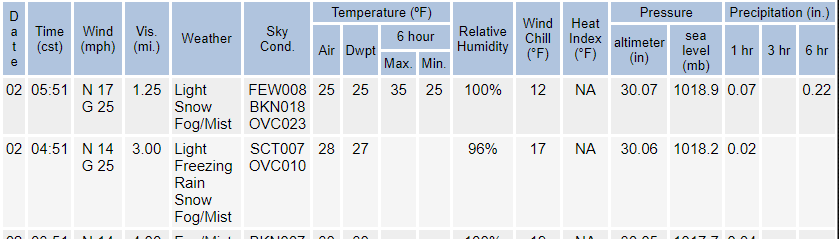
Transitioned over to snow maybe 30 minutes ago, temp 33.
-
I think we may be in for a surprise. Mid 30s on ground in St. Louis and current sounding is suggestive of snow, which would imply the entire event is snow, a much colder scenario than modeled. QPF for short range guidance HRRR and RAP is around 0.5. Assuming sub 10:1 rates, the 3-5'' call seems like it would be accurate with amounts on the higher end of the range. I hope I'm interpreting this right.

-
LSX AFD mentioned they expect a changeover around 02-04z [8-10pm] in St. Louis, which seems a few hours earlier than most guidance. They're basing it on some AMDAR soundings out of lambert that showed a weak warm layer extending to 850mb [<1C], which they feel will be rapidly washed away as heavy precip pulls cold air down. They're sticking with 3-5'' call, which is very bullish to me. I'm hoping they're right, we'll see how it plays out
.png.16f03aa813b1850fd8cefd467ae27d6c.png)


Feb 1-3rd GHD III Part 3
in Lakes/Ohio Valley
Posted
I've been in 20-25dbz returns for the last hour or so, I'll take a short walk to get sense of depth. Visibility slightly under a mile I want to say. Temp is 17.