
203whiteout
-
Posts
59 -
Joined
-
Last visited
Content Type
Profiles
Blogs
Forums
American Weather
Media Demo
Store
Gallery
Posts posted by 203whiteout
-
-
4” Fairfield CT. 20” season total.
.-
 1
1
-
 1
1
-
-
4” Fairfield, CT. Season total 20”
. -
[mention=12274]The 4 Seasons[/mention]
This was taken at around 2:00, after the brunt of the snow was finished. 5+ inches reduced to a few inches of wet, nasty slop. Utterly useless, and terrible. Winter sucks. My spot is like living in the mid-Atlantic. Besides some random Connecticut island in the Long Island sound this area is the worst snow spot in the state, and probably all of new England.
Where are you located in CT? I was out and about around Fairfield county earlier this morning during the height of the storm - (Fairfield-Easton-monroe-newtown) and also just drove up rt 8 to Thomaston and back to Bridgeport. Btw, Naugatuck valley to Waterbury to Thomaston got ROCKED! Easily foot plus and way less compaction vs the shoreline.
This morning I got out in Easton and Monroe during the heavy rates and was getting a lot of measurements around 10 - 14”. Even Greenfield Hill, Fairfield had around a foot this am, but then as the sun got higher and the rates subsided, it all compacted down to what looked like 6-8”. I think some people waited too long to measure or measured during slower rates which, in this storm, could be the difference between measuring 12” vs 8”.
Finally looks like winter around here in SNE again. Hopefully this is the storm that ended the snow drought. I hope..
. -
About 12” Fairfield CT - north side of town. Can’t believe it’s been 2 years since snow like this. It could have been 2’ if we had better ratios, but I’ll take it!

.-
4
-
-
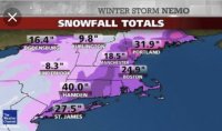
10-15” pretty much state wide CT from the overnight runs. Good start to 6z..
.-
 1
1
-
-
Thought it would be helpful to have all of the relevant model snowfall maps from 0Z in one place, as I'm constantly trying to remember where they might be in a thread especially when looking back at a storm which I sometimes do. I'm only including the 10:1 ratio maps for brevity and because those at least give one the total precip as snow, too, which is important. Pretty impressive all together.
I think we've all discussed ad nauseum how for this storm, especially for areas S of 78 and east of maybe the NJ TPK, surface temps are likely to be in the 33-35F range, leading to melting/compaction and there could be a warm nose aloft for some period leading to some sleet, both of which would make the snow ratio produced up high in the sky (which should be >10:1 given great dynamics in the DGZ) something perhaps considerably less on the ground as accumulated snow (maybe 7-8:1 and could be even lower at the coast), so take these maps as starting points for how much snow might actually accumulate.


BDR and coastal CT looks good as of 0z..from that blend I’d go 8-12
.-
1
-
2
-
-
Huh that was quite the trend down here tonight. If it stays like this past 12z then I’m sold.
What’s the surface temp on euro during height of storm for coastal CT?
. -
Try 36 hours out
It is 36 hours plus away here. 48 hours from now is midnight Tuesday, long after the snow has stopped. This is happening.
. -
4 hours ago, The 4 Seasons said:
HRRR looks pretty damn cold too, not a threat of mixing even close to CT and surface temps look to be in the upper 20s for most of the event
can you post images?
-
4 minutes ago, Sn0waddict said:
So on NOAA Milford reported 11.3 at 1000am. if that is right then we definitely broke a foot here which would be a huge win all things considered. I thought we had less at the time but it’s tough to dispute given all the drifting. It definitely did feel like we had more today than the 9.5 we got a few weeks ago.
You got over a foot lol we got about 14” in BPT on the water (black rock) Fairfield has a measurement of 16.2 at 3 pm
-
Very tight gradient here in Fairfield county. 6-8” storm for the majority of the county but eastern Fairfield county along the beach got hit hard (Fairfield, Bridgeport). The gradient was very obvious while out driving. Just saw a report of 16” in Fairfield and 10.4 was the last I saw at BDR airport at 1pm and I figured they got an inch or two on top of that.. anyways we were right on that edge
-
14 minutes ago, EastonSN+ said:
Ha as usual my yard has the lowest amount.
Bridgeport town just SE 10
Fairfield town just south 9
Trumbull town just to east 7 a while ago.
Heck Stamford on NYK boarder 7.
Somehow my yard is cursed WRT snow depth.
Yea man we have a foot easy here in Black Rock. I think those totals in Fairfield and BPT are from this morning. I just got home, highest amounts I saw are here, very tight gradient NW of Fairfield
-
3 hours ago, Jt17 said:
Does anybody have a favorite radar they can recommend?
NEXRAD. I’m in Bridgeport CT so I use the NYC radar
-
1 hour ago, Sn0waddict said:
If I get Juno’d again I’m gonna have to think hard about whether this is a hobby I want to continue in my life lol
Very similar pattern.. honestly wouldn’t be surprised if we get shafted here in SW CT bc The pattern is so similar to that when Juno happened. Let’s see where the bands set up. Models are now pretty much useless at least all but the short range models and even those are stupid bc at that point it’s better to just look outside and look at the radar lol
-
15 minutes ago, skierinvermont said:
yes I think the downloping is worse from Westport/Newport over to the CT river. Only 12-18 for SE CT in '05
What is downsloping? I’m on the coast here in Fairfield CT and it seems we have had a pretty good run here with 2’+ storms. 2006 was great for us (30”), 2013 was great (35”) we do well with those (further west than modeled) death bands. They seem to set up in a similar location every time almost running through interior Maine SW through NH/VT and then south through western Mass and western/central CT. Hope you guys do well with this one.
-
1 hour ago, North and West said:

.Lmao
-
 1
1
-
-
Also 8mb weaker. GFS is not handling this storm correctly (my opinion). Big storms come west. This is a BIG storm. We’ve seen this so many times before. If 12z euro goes east then yeah, I’d expect this to be mostly a ENE storm…
-
Ended up with another about 8 or 9” here in SW CT. Nice little event for sure. Loving the pack developing here. Looks to only get deeper too! Starting to look like 2011 and 2015 around here!
-
23 minutes ago, WinterWolf said:
We coat, we cover, we soothe ...moderate snow now 27 degrees. Looking nice.
Where are you located?
-
20 minutes ago, cut said:
Viz under 1/4 mile in Bridgeport. I would think nearly or just over 1 inch per hour. Looks like 5 + should be a lock here. Maybe even 7.
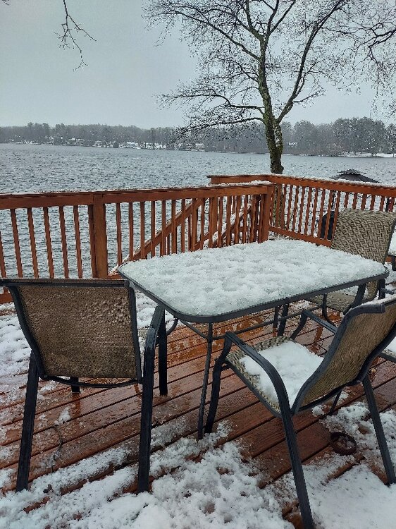
Snow breeds snow. I’ve always believed in that. Bands are setting up in similar areas as last storm it looks like. White out conditions in Fairfield. Probably at least an inch per hour rates at moment. 30 degrees.
-
I think we are mostly done here with the accumulating snows. Great storm for coastal SW CT. 18” total. If we can squeeze out another inch or two, it’s all extra
-
2
-
-
9 minutes ago, The 4 Seasons said:
yea Feb 03, Jan 11 and Feb 13 were all 20+ here. Thats about it for big ones.
Feb 06 30” Fairfield
-
7 minutes ago, EastonSN+ said:
Anyone from Easton CT or far north Fairfield able to send a snow total?
I swear there is something wrong with my yard. I measured in the woods out the woods. Just stuck the ruler in the ground. Averaged 13 inches. It HAS to be low.
I’m in black rock on water and am averaging 17” still snowing pretty good
-
2 minutes ago, Sn0waddict said:
They had 12.5 90 minutes ago
They had 10.5 at 12:51.lmao that measurement is not correct

Saturday February 16th - Another CT/ Cape special?
in New England
Posted
That squall line in Fairfield/New Haven counties what savage! I’d say close to an inch in some spots in less than 20 minutes! 10” on Tuesday, some mood flakes Wednesday night, 3-4” of fresh snow to refresh our “mini pack” this morning and a quick half inch to and inch this afternoon under the squalls! 21” season total here on the SW CT coastline. Not great and below average but I’ll take it, considering the start to our season and the amount of snow we’ve gotten, despite the above average temps and pattern we are in..
.