

mstr4j
-
Posts
18 -
Joined
-
Last visited
Content Type
Profiles
Blogs
Forums
American Weather
Media Demo
Store
Gallery
Posts posted by mstr4j
-
-
All these low-key posters on the threat threads. I don’t want ice and power outages....but you know they do! SMH.
-
14 minutes ago, Eastatl said:
What are the chances of this moving further south into Atlanta?
Better chance in the upstate of Sc but that’s looking slim too - thankfully!
-
Drought is over! Maybe trace to 1/2 inch here outside of cowpens in Spartanburg, SC and thankful for every flake that flew! Drove up to a friends house in Landrum/Campobello areas and they had a solid 2.5 inches on the ground by 10:30. Wouldn’t surprise me if they cashed out over 3. To those that didn’t get squat, trust me I feel your pain - Hoping for a big one later on this month!
-
14 minutes ago, Looking to the skies said:
NWS in Atlanta aint impressed with no Models or ensembles..... They just issued a statement 1, 1.5 inches in the NE Mountains..... Nada anywhere else basically
CJ on WYFF4 is also unenthusiastic about the event.....which brings hope? This is a Tough One To Call but as I say, heart break is for country music / I am ALL IN - come on upstate of SC
-
 3
3
-
-
20 minutes ago, BooneWX said:
Well, on the bright side, if I count all of the dustings this winter, I may be getting close to an inch of snow on the year.
An inch more than in my neck of the woods!
-
Left Landrum several hours ago and it was pouring snow and drove up 85 and it was rain and freezing rain. Finally switched over an hour ago and it’s piling up quick. Hope the HRR will be good to me till around 6AM and a nice snow is on the ground - Doubt I’ll sleep tonight until I hear the sleet coming down in which I’ll cry myself to sleep - Haha!
-
2 minutes ago, drfranklin said:
interesting, I'm at 38.5/37 - temp very dependent on rates - 2 miles north of I-85 near DT Greenville - mixing occurs with higher precip rates - precip lightens and the temp can rise 1/2 degree and mixing stops
Guessing it takes longer to come East up 85 - sitting on the northern eastside of Spartanburg county - all signals seem to be pointing at an ice storm for our area, we shall see
-
5 minutes ago, Blue_Ridge_Escarpment said:
Ouch. Lights out for weeks if this verifies in S NC and N. SC
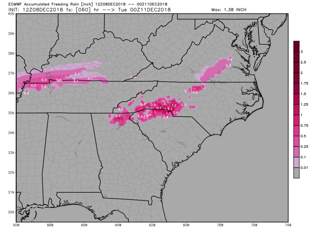
I agree that any accumulation could be bad but don't bank on those totals actually accumulating. No where near cold enough at surface, should be raining heavy at times which minimizes accretion
-
Our temperatures in the upstate along 85 have hardly budged. Looking at 42-43 with a DP in the upper 30's. Been reports of light sleet and wet snow north into Inman and Landrum. Banking on the HP doing its thing later this evening to really cool down the surface temps.
-
1
-
-
3 minutes ago, burrel2 said:
absolutely... I didn't mean that the chances stop at travelers rest. I would love to be living in Landrum right now!
absolutely - I work up that way and told many that a potential huge snow was coming their way - I'm probably 10-12 miles south and east of Landrum right on the I-85 corridor but luckily my area IMO is still considered Northern Upstate - it's such a sharp gradient in these locations! Hoping for a bigun!
-
2
-
-
1 minute ago, burrel2 said:
Hrrr is getting GSP down to 28 degree's by 8am Sunday. That's 4 degree's colder than any other model has showed to this point. Even more impressive when you consider the Hrrr is typically torching at the end of its run.
It's also flipping the rain over to a major sleet storm by midnight for most of the upstate including hart/anderson/newberry counties. If the wedge can get cranking that quick this could still be quite a winter storm for us.
One concern I have is the backside of the precip looks to fly through here around 3 or 4am; and the development of precip in the dry slot behind that band is usually questionable in coverage and intensity.
Burrel I hope its right - My issue early on and even now are marginal temperatures at best. Many have talked about it being an issue in the upper levels but I think it is still a major deal on the surface. Temps did not get as cool last night as originally forcasted so even more radiant heat must be expelled. Us GSP-I-85 people understand how hard it is to get even the surface levels down to below freezing then mix in some upper level warmth from the low in the upper levels and it has potential bust written all over it. I'm no expert, don't claim to be just a redneck with a commonsense approach to figuring out what will hjappen in our area. We need to hope the HP funnels some cold air down in a hurry! And hopefully it will!! This is no shot at mets and professionals, what they do is hard, especially in this region. They all do a great job
-
Seems to me that GSP and Upstate struggling these past few runs - but it doesn't take but one to turn this babe around!
-
4 minutes ago, SnowDawg said:
I agree. The NAM is definitely better at identifying the intensity of a CAD than the globals, but with its setup at the end of its runs as far as its concerned there’s not much of one there because of the placement of the bigger synoptic pieces. At this lead time the globals likely have a better handle on the placement of things, the NAM would just be better at translating that look to the surface at a higher resolution. Assuming the globals have the big picture right, it’s hard to give much credence to the recent runs on the NAM.
This was the basis of my question earlier that I wasn't sure if someone answered it. It is of better hope that the global models pick up much better with the HP placement and strength while the NAM does better with the thermal profiling of the CAD once the HP is set in place?
Also someone mentioned earlier that I wasn't sure if it had been answered. Is the fact the NAM is much closer to the event over the southern plains region should we use that model trend as a better gauge for what's going to happen in our neck of the woods. Or since it's a CAD event, the NAM's trending projections of the southern plains isn't as neccessary to what happens in the South East? Any input is appreciated, thanks!
-
2 minutes ago, Tony Sisk said:
I'm assuming a youth in HS. Fantastic to see youth interested in weather. Keep up the great work, and hopefully others at your school are interested. One of my fondest memories from HS 78-81 was a young boy with special needs that memorized the weather every day. There are lots of excellent weather sources here...follow your dreams. Hope you make a LOT of people happy this weekend!
sorry for the banter, just wanted to encourage a student!
Tony, though I act like a kid many times - I wish I still were - I'm a gradually wilting away adult that holds on to snow models that makes him feel young again! HAHA!
-
3
-
-
11 minutes ago, PackWxMan said:
I think we all need to take a few deep breaths. We are close. But this is the same thread different year. Only difference, we aren't in late jan, we are in early Dec.
If I may, I would like to play devils advocate here.
Let's do the say it outloud test. "Model are showing widespread 10-20inches across NC in early december" - We know how this plays out with moisture robbing, warm noses, etc. It doesn't end pretty boys.
I'm the weather guy at my school, granted not a good one, mainly the guy that tries to regurgitate all the information I read on here. Granted I am also the one that loves snow and I have seen the term giddy several times on here and I'm that times freaking 20. BUTTTTTT, dadgumit there's always a but - is it really possible for this to happen without WAA and everything Pack said? Who knows? Being the optimist, no one thought david could win either. #BeatGoliath #LetItFreakingSnow
-
4
-
-
Long time avid reader and first question ever on this AWESOME forum. My question for you weather experts is this (I Hope it's not confusing as I am still learning) - I understand that the NAM does a much better job at predicting and forecasting CAD events much better than global models. My question is however, does the NAM do well with forecasting where the actual location of the HP will be, or only if the HP is actually there then it determines the strength of the wedge. Virtually as the event is closer is it actually better to watch the NAM as a higher resolution model that doesn't do well with actual forecasting of where that High will be orrrrrrrrr watch the global models position of that HP and then go with the NAM's thermal profile? Make sense? Either way, been a great time following this forum and this HUGEEEE Winter Weather Threat
-
1
-

February 18-19 MAJOR Ice Storm Threat
in Southeastern States
Posted
I personally wrote this one off because of my location of being extreme northern end of Spartanburg. But it is alarming that the temp and dew point here in Landrum are the same as Asheville on weather underground being 47/22. I could be wrong but I think there’s even more dry cold air on the way so we will see but I hope like HELL this doesn’t verify.