

miamarsden8
-
Posts
113 -
Joined
-
Last visited
Content Type
Profiles
Blogs
Forums
American Weather
Media Demo
Store
Gallery
Posts posted by miamarsden8
-
-
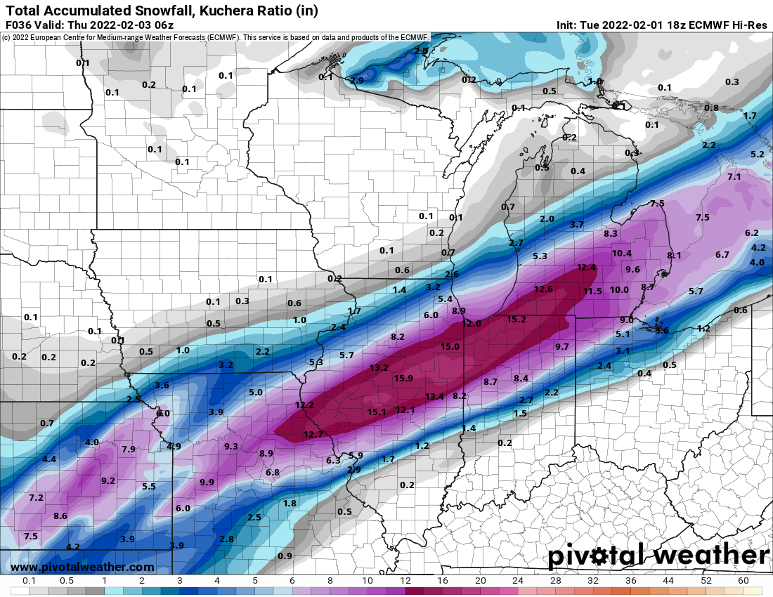
1 hour ago, WXMan42711 said:

So what you're saying is Cincy is back in the game? LET'S GOOO! (and I'm going to hope like a weenie that this map is right; I want more snow!)
-
 1
1
-
-
1 hour ago, Spartman said:
But....

Ah, I see. The Cincinnati folks are going to be sad. Understood.
Actually, it all depends on the temperature at this point, but I'm losing hope.
-
Cincinnati suburbs forecast: 1-2"
Ryan Hall: Nah, you're wrong, it's going to be more like 3-6".
Actual snowfall: 5" and counting.
Normal people: Ew, snow. What is this?!?!?!
Me: OH GOD YES!!!!!!!!It's a gooooood day to be a believer in snowfall! If the Bengals win, it'll be a perfect day for me. If this is an appetizer to the storm next week, I'll have hit the jackpot!
-
5
-
-
So...you're saying there's a chance this thing smacks Cincy?
COME ONNNN let me have one real snowstorm here.
-
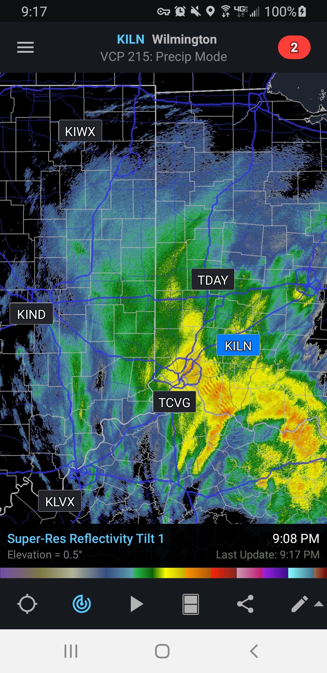
In northern Cincinnati around Sharonville, it's just straight up pingers. Looks like about an inch or two of sleet is on the ground, so that's a thing. This is not looking good for our snow chances.
-
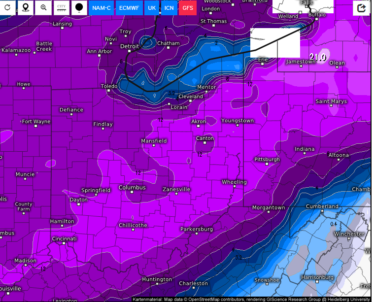
Additionally, none of these models seem to be in agreement. It's basically 1 inch or 12 inches. Cincinnati is weird, man.
-
 1
1
-
-
Our forecast calls are getting wild. Per weather.gov's Winter Storm Warning for us:
* WHAT...Heavy mixed precipitation expected. Total snow
  accumulations of 3 to 6 inches and ice accumulations of up to
  three tenths of an inch. Winds gusting as high as 35 mph on
  Thursday.
Then you go to weather.com's forecast:
Thursday: A mix of wintry precipitation in the morning. Then periods of snow expected in the afternoon. Potential for significant icing. High 31F. Winds NNE at 10 to 20 mph. Chance of precip 100%. Snow and ice accumulating 8 to 12 inches.
Thursday night: Snow in the evening will transition to snow showers overnight. Some sleet or freezing rain possible. Low 18F. Winds NNE at 10 to 20 mph. Chance of snow 90%. 1 to 3 inches of snow expected.
Then accuweather is like "yeah 1-2 inches". It's like...absurd. I've never seen forecasting like this before. In western Illinois, at least I was prepared for weenie numbers ending up depressing. This just tells me not to trust anything and just kick back and relax.
-
 3
3
-
-
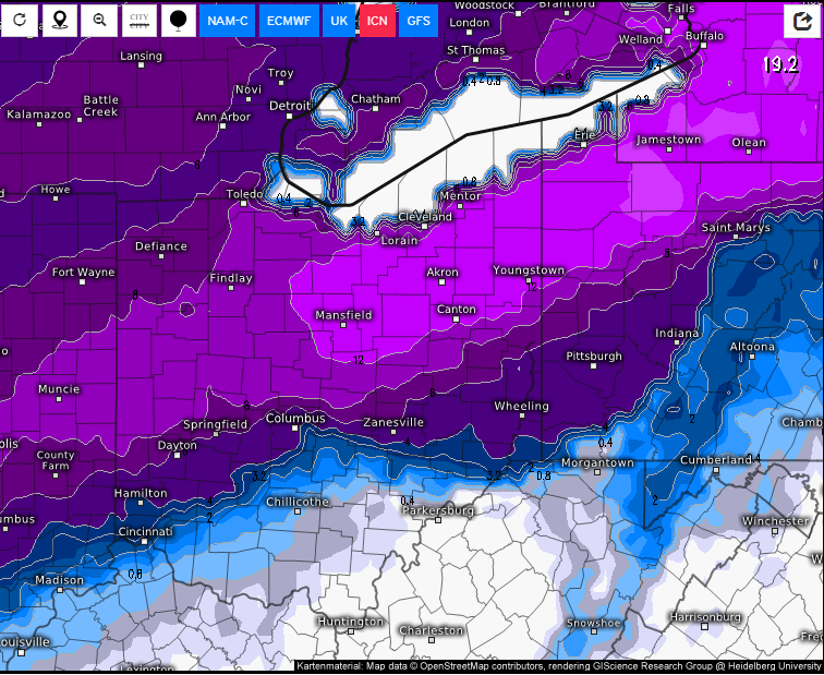
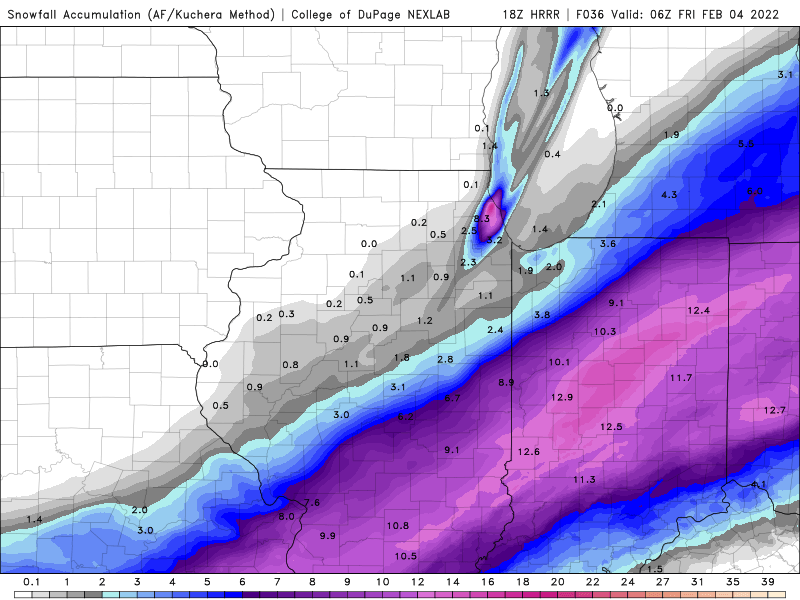
8 minutes ago, Lightning said:
Exactly. Plus in MI use 10:1 and not Kuchera ratio. I am ending pleasantly surprised with this storm.
Being in Cincinnati is the worst for snowstorms because either you get a dusting, rain, or 6 inches, and it's never in between.
-
1
-
-
5 minutes ago, WestMichigan said:
RAP and HRRR were showing some big totals in my area last night also. You would be safe if you halved that and be pleasantly surprised if it comes in higher.
That's why right now, I'm still feeling like...so HRRR has 9 inches and this has 12. A 4-6 call seems safe especially since it's been pouring down rain all day. And honestly snow melt is going to make it difficult to get an accurate measurement. Even if we get 8 inches, it might look like much less if it doesn't stick quickly.
-
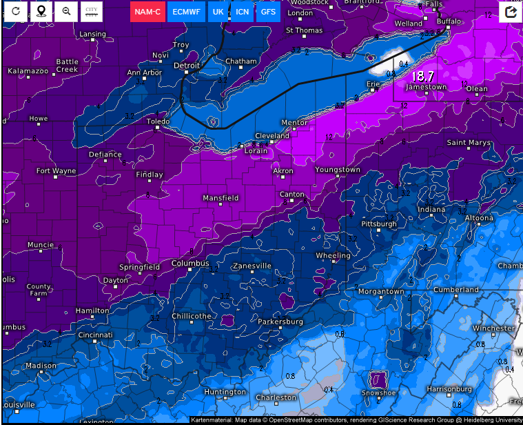
1 minute ago, Jackstraw said:
Here, take a look at the 21Z RAP


This has to be a weenie map. We would not get this lucky in Cincy to have both a real blizzard (ish - keep in mind this is 2022, and 20-30 mph gusts might approach that territory) and an AFC Championship in the same season lol
-
2
-
-
8 minutes ago, Jackstraw said:
18Z GFS hittin' the glass pipe again? Still has 15 here when all is said and done and I can still see grass right now. Ill take it lol

Okay, but weird thing is while this is a weenie map, it's also the second model indicating a southeast shift in the snowfall totals. Please, please, PLEASE keep coming southeast.
-
3
-
-
11 minutes ago, ILSNOW said:
So, you're saying there's still a chance for me getting 6-8 inches in Cincy? :')
Honestly I think we'll see 2-5 inches, it feels like it's going to be a disappointment.
-
1 minute ago, ILSNOW said:
18z Euro thru 36

Lol Euro can you not quash the remaining hope I have? Such tight gradients, such a difference between a mix, an ice storm, and a rain only event. Yikes!
-
Up in the suburbs of Cincy, I'm hoping that this storm shifts a bit further southeast. We're about 2 counties away from hopefully not dealing with a crippling dose of concrete, but if this thing comes northwest, I could see it being a devastating ice storm especially for the city. 0.5 would be enough, 1 inch would be bad.
-
1
-
-
So after viewing the radar, it looks like unless some disappears, it should snow for 6-8 hours at least (maybe more). If we see rates of 0.5 inches per hour, that's 3-4 inches.
-
Just now, Cuteirishgirl25 said:
I don’t trust it either, but you never know, remember what happened when everybody predicted a couple inches for our area and we ended up with 10 inches. So you just never know
I only got 6 or 7 in Fairfield. It's like, I felt shorted.
Either way, I know what you mean. I could see 5-6, don't get me wrong, but I also know that when all the models thought we'd see a foot, we got 2 inches.-
1
-
-
18 minutes ago, Cuteirishgirl25 said:
3k Nam has 5-6 inches in Cincinnati area
I'll believe it when I see it. Not trusting anything lmao
-
There's definitely potential for something in the Cincy area...I just have no clue how much. I think we'll eventually see this thread expand as soon as the people watching from the last storm are finished with that. I'm just hesitant to count any chickens before they hatch after that storm last night.
-
After going outside, I'm not sure what to make of any of this. It definitely got to 3.5-4.5 inches as of now, but it's basically light snow, and unless more builds up, we're looking at the end in Fairfield. We dodged the cool bands that went through Mason, and honestly, ending at 5-7 inches is fine, but there's a part of me that's really unsure what to think at this point. We had 2 inches by the end of the early band, so getting 3-5 out of this later band is very interesting, if nothing else, given how much more potent the later band looked. It's not over - time will tell obviously if we get more snow building - but as of right now, my optimism isn't very high. That said, seeing the pictures from Indiana has been the highlight of all of this, and I'm really glad to have at least bore witness to one of the most interesting storms I've ever seen. Just didn't play out in my favor this time, got 7 out of the last storm (the one that dropped 10 in the city of Cincy itself), so really, given the fact that last winter, we were lucky if we got 7 inches, I guess this is something comparatively.
And all the models were in agreement for so long to see 6-12 inches, so I don't blame anyone. I know it's not an exact science, but I also knew that A: that dry slot was trouble, and B: I knew those NW shifts were going to end the game.
-
1
-
-
Just now, OhioWX said:
Very impressive snowfall rates around here. ILN tweeted about rates as high as 1.5" per hour. Sadly, I don't think it'll stick around long enough for any significant accumulation.
I guess it depends on what you consider significant. It could probably be here til like 1 am, which could give you theoretically 6-ish inches. That's significant.
-
1 minute ago, Stebo said:
Gravity waves down near Cincinnati.
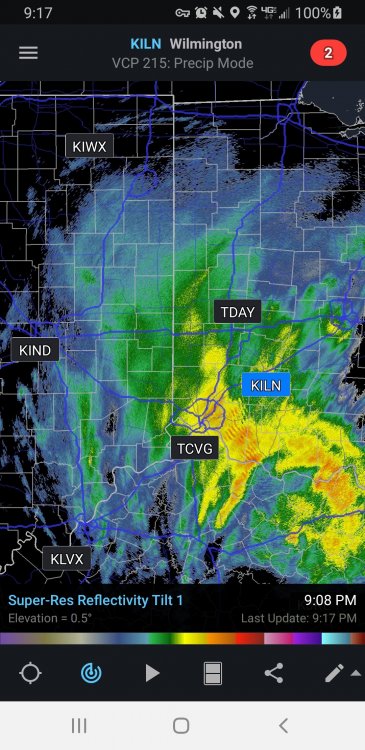
I'm just west of the yellow oh come onnnn!!!
Fairfield just can't win lol
-
We're getting middle-sized flakes in Fairfield...vis around .5-.75 miles.
-
Dry slot seems to be filling repeatedly in Fairfield with light snow. No clue what to think of any of that.
-
1 minute ago, Snownado said:
I wonder why TWC chose to go to Cincinnati instead of some other cities ? Not sure Cincinnati will be the jackpot.
I can promise you it won't unless we get a sick, sick band. I'm talking 1-2" an hour.
-
1
-
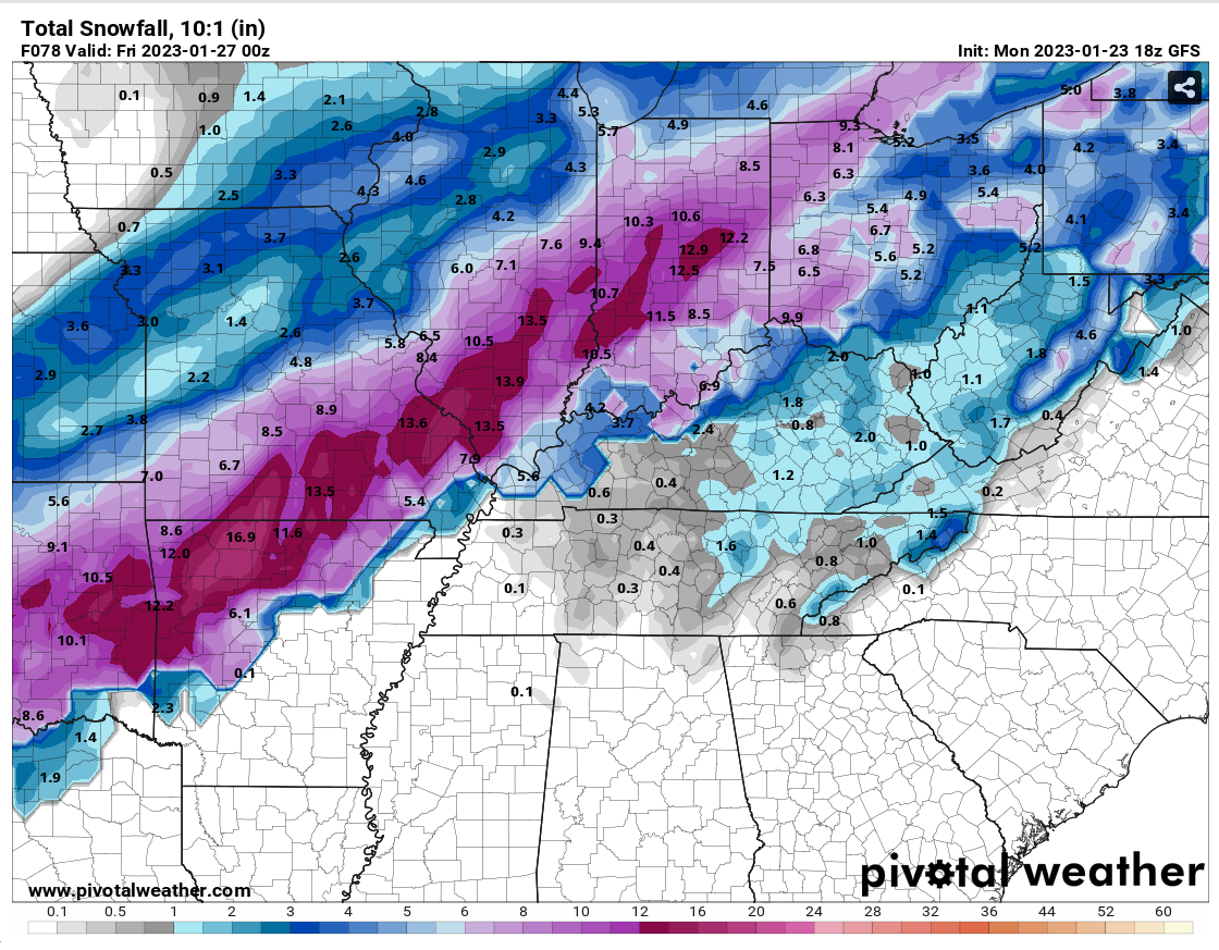
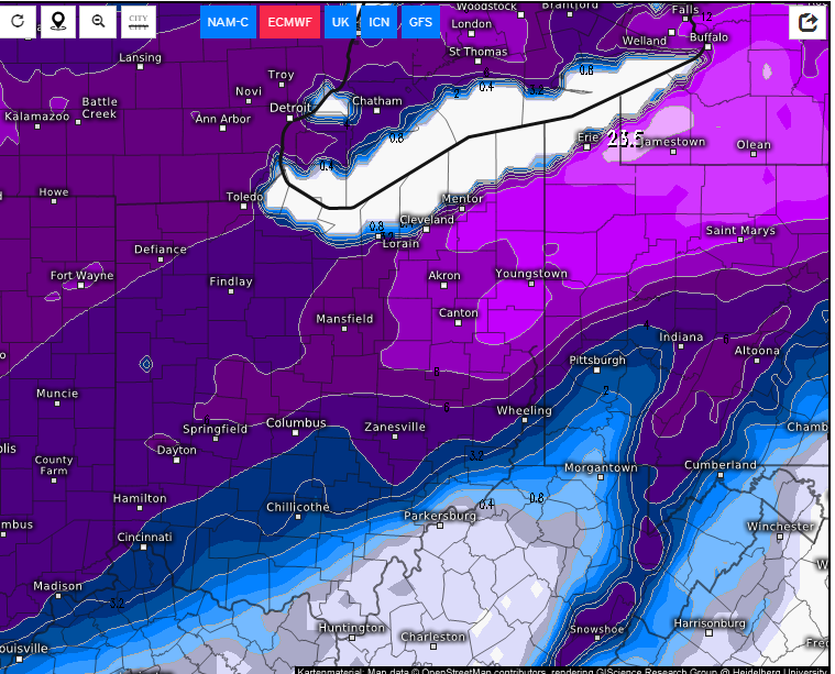
Midwest/Ohio Valley/Great Lakes Snow January 24-26
in Lakes/Ohio Valley
Posted
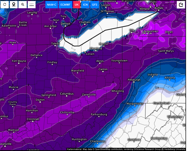
I feel like this is a storm where 1-2 degrees is going to matter immensely, and I wonder if there's a chance that these models are overdoing the temperature a tad bit. I don't deny that it's likely we will see rain in this system somewhere, but what I'm sitting here thinking is we have a few inches of snow on the ground here in Cincy, so I wonder if that will help keep the temperature cool. Upper 30s isn't necessarily hard to believe, don't get me wrong, but 1-2 degrees could be the difference between 4-6 inches of snow (the ILN office is calling for that) and a mostly rain-only event, so I'm just not certain I'm confident at this point in that 4-6 inch call. The ILN office has us reaching 39 degrees, but if snowpack affects that enough, I could see us topping at the 36 degree range.
I guess TLDR, I have a hard time believing ILN after looking at these models, and while I do think that warm air bubble is going to matter and certainly will reach Kentucky in some fashion, I could see it being overdone for sure. All I know is that gradient over Cincinnati is gutwrenching. My call, if I had to make one, would be 3-6 inches, but I wouldn't bet on it. There are just too many unknowns. But it'll certainly be exciting, if nothing else, to see how it progresses through the midwest.