

Gosnow
-
Posts
44 -
Joined
-
Last visited
Content Type
Profiles
Blogs
Forums
American Weather
Media Demo
Store
Gallery
Posts posted by Gosnow
-
-
17 minutes ago, MillvilleWx said:
Still my first call and I'm at work, so I'll do a fine tooth comb and have a Final Call later today. Might make some adjustments. But in either case, this is a storm where banding will be key. You get a few good waves and 4" is easy money for my PA brethren
")
Ty Millville for putting in the extra effort for us back here. Always loved reading your thoughts on what was happening. I hope you end up in one of your choices for forecast area.
-
 2
2
-
-
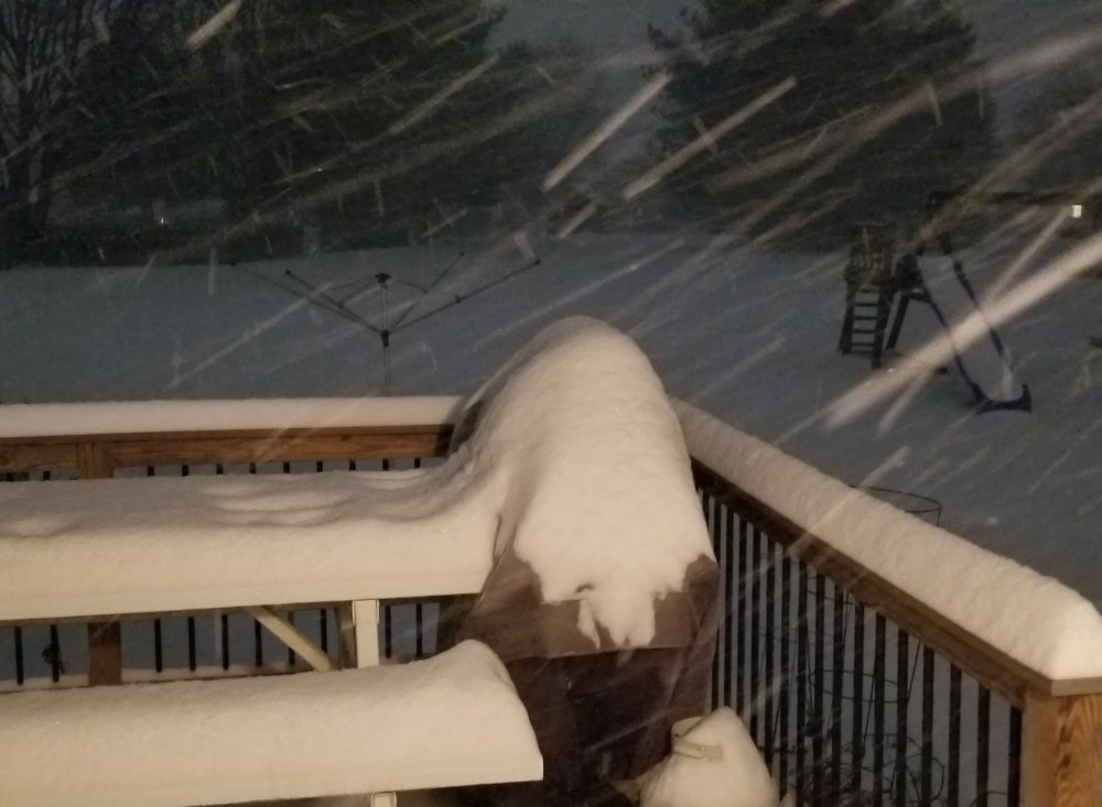
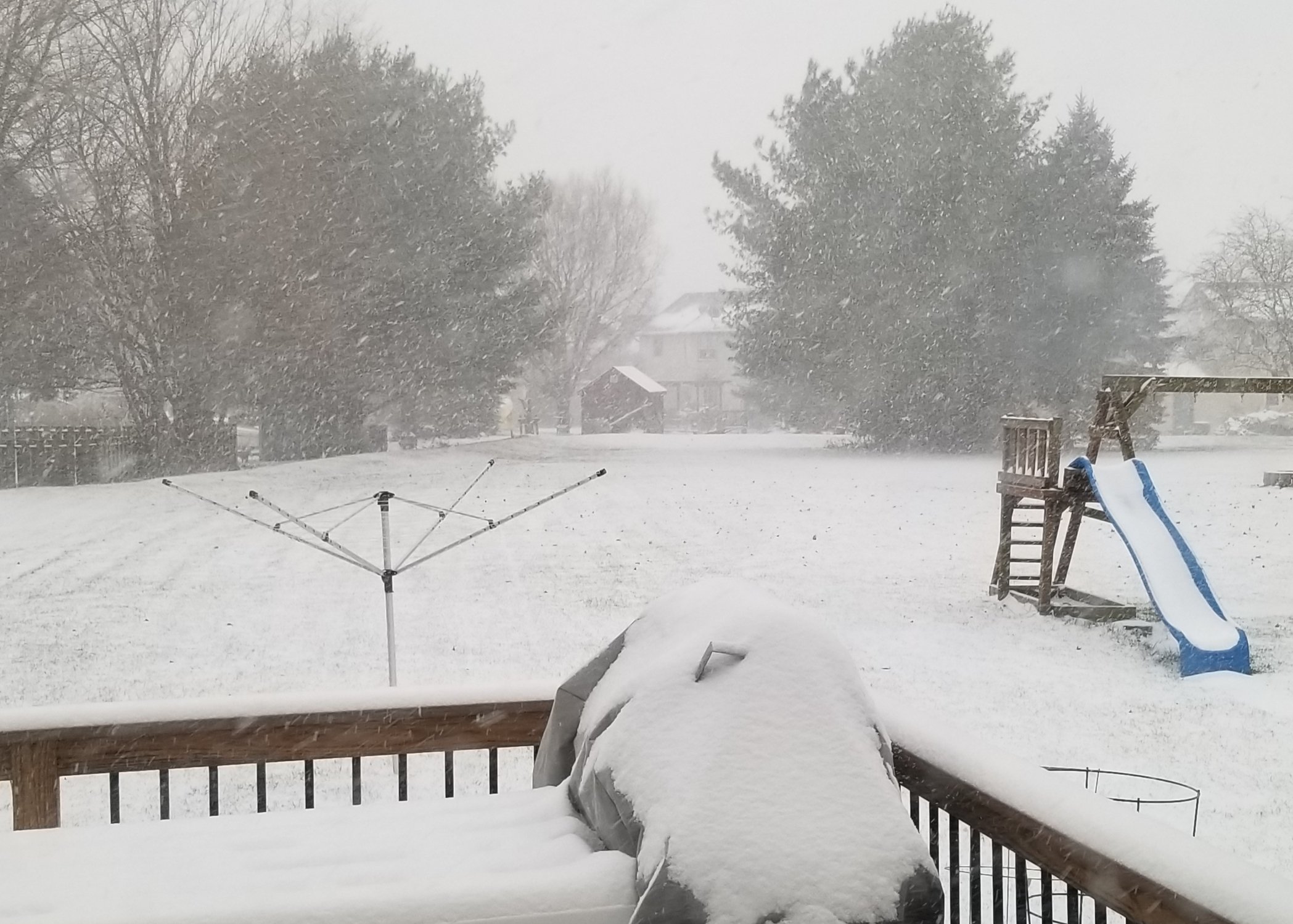
Light snow in Lititz. The storm that keeps on giving.
-
1
-
-
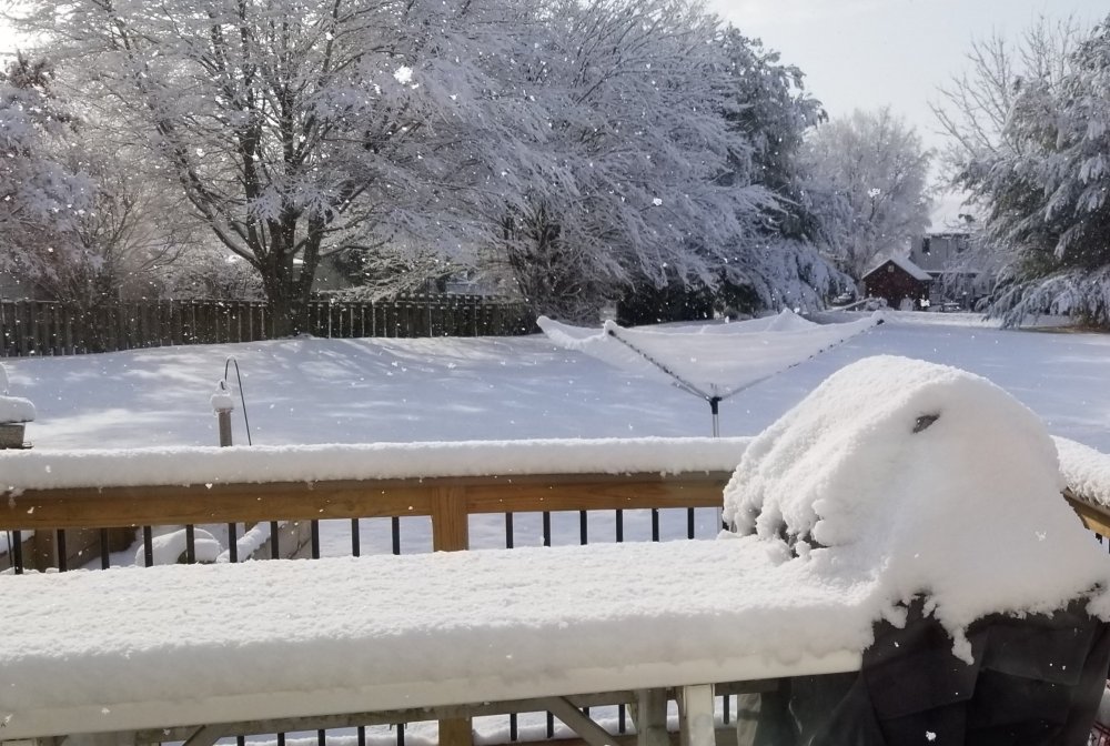
Beautiful snowy day in Lititz. Keep it coming.

-
2
-
-
Quick question? Lancaster showing wintry mix keeping down amounts. Do the thermals support that? Also with the globals showing high amounts in lsv nws seems to believe the lower values from other models. Is it better to be conservative from their pt of view when there is a difference? Thanks in advance for any replies.
-
1 hour ago, pasnownut said:
Dude I did NOT expect that but totally dig it.....
see what I did there? Lol

I'll buy that for a dollar!
-
17 inches snow
1.3 inch precip
-
Wet here with what looks like some melting sleet on the deck. No snow that I saw, but as others have said, it could have been overnight when the 25 or so flakes fell.
-
1/27 what could go wrong.
")
-
1
-
-
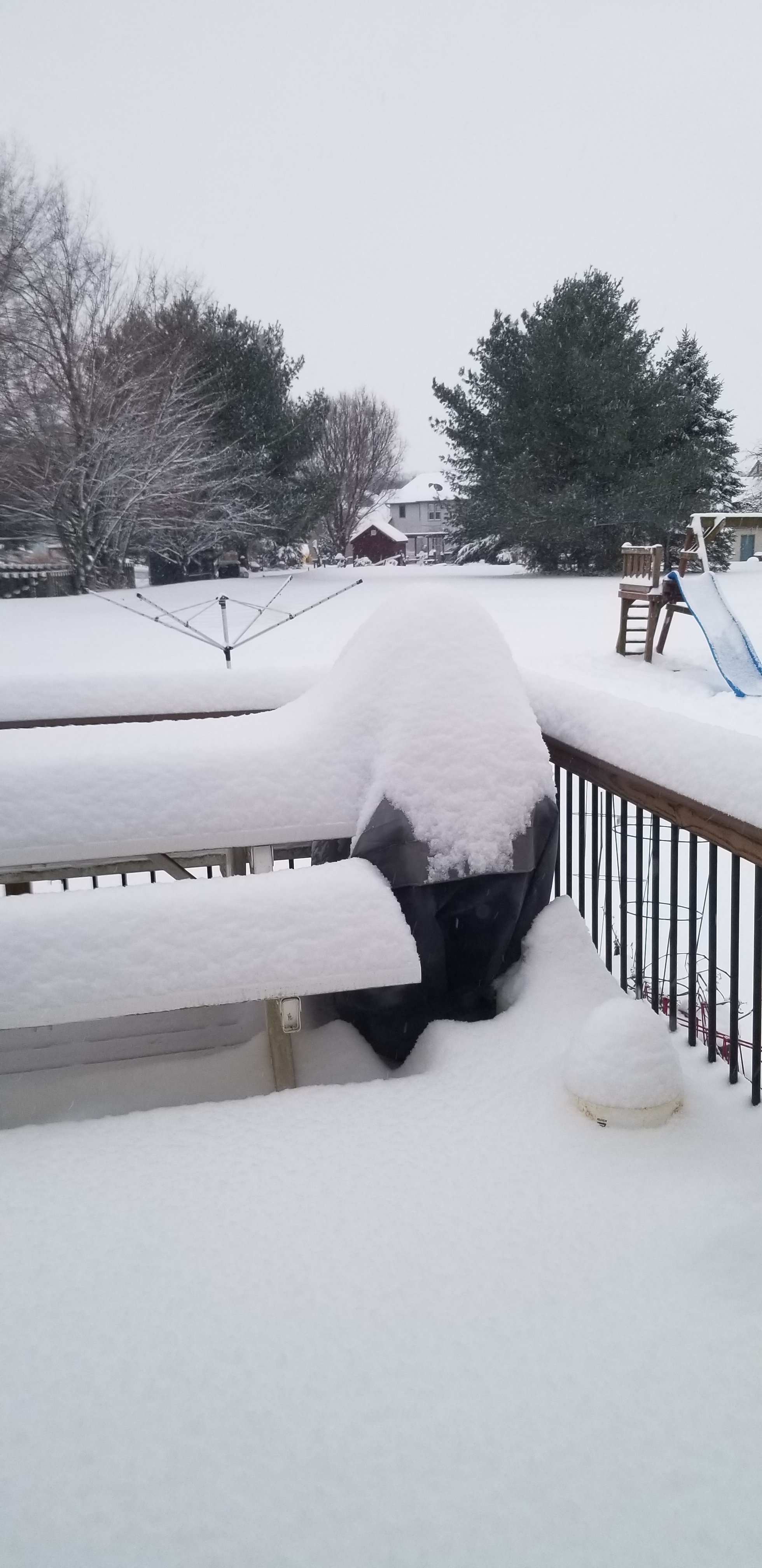
Heavy snow lititz northern lanco. No mix i see.
Beautiful sight.
-
From lititz in northern lanco.

-
2
-
-
13 minutes ago, pasnownut said:
It's been long overdue. Finally something worth remembering in 2020 for what has otherwise been a horrid year for many.
Separate thread in hopes that it's one to remember for most if not all of us. Been a long time since a forum wide event like this has happened. Hoping it's bookmarked for years to come.
NWS forecast basically at go time.....
Discuss, good luck to all..... and enjoy.
Nut

This is what in Lanco we call our wishful thinking..... after many beverages of choice.
-
1
-
-
Just wanted to say:
Here on the forum we wait for snow,
For all of us it makes us glow.
Which is what was needed during this year,
To bring us all some laughs and cheer.
And while not certain of how much we get,
All of us hope white and tons of it.
But I really think what is so much fun,
Is sharing the love of snow on here with everyone.
So enjoy it and let it bring you cheer,
Along with all your special beverages I hear.
And when this snowstorm is finally done,
Let us look forward to tracking the next one.
Enjoy all!!!!!!
-
3
-
-
I think i saw someone wanting thundersnow? From state college afternoon discussion.
This target area will see a one-two (maybe even three) punch of
warm advection heavy snow later Wednesday afternoon and
evening, followed by a period of peak CSI-banded heavy snow with
the potential for Thunder snow later Wed Evening through a few
hours after midnight as the nose of a strong 50-60 kt easterly
850 mb jet and 130 kt upper jet focuses hefty uvvel and
slantwise instability near and just to the NW of I-81.
-
52 minutes ago, pasnownut said:
12z

18z

I like the expansion of greens throughout PA.
-
Winter Storm Warning
URGENT - WINTER WEATHER MESSAGE
National Weather Service State College PA
430 AM EST Tue Dec 15 2020

PAZ026>028-035-036-056-057-059-063>066-152130-
/O.UPG.KCTP.WS.A.0001.201216T1500Z-201217T1500Z/
/O.NEW.KCTP.WS.W.0003.201216T1500Z-201217T1200Z/
Huntingdon-Mifflin-Juniata-Fulton-Franklin-Perry-Dauphin-Lebanon-
Cumberland-Adams-York-Lancaster-
Including the cities of Huntingdon, Mount Union, Lewistown,
Mifflintown, McConnellsburg, Chambersburg, Newport, Harrisburg,
Hershey, Lebanon, Carlisle, Gettysburg, York, and Lancaster
430 AM EST Tue Dec 15 2020

...WINTER STORM WARNING IN EFFECT FROM 10 AM WEDNESDAY TO 7 AM
EST THURSDAY...

* WHAT...Heavy snow expected. Total snow accumulations of 12 to 18
  inches with locally higher amounts possible.

* WHERE...South central Pennsylvania.

* WHEN...From 10 AM Wednesday to 7 AM EST Thursday.

* IMPACTS...Travel could be very difficult to impossible. The
  hazardous conditions could impact the morning or evening
  commute.

* ADDITIONAL DETAILS...Bands of heavy snow with accumulation rates
  of 2 to 3 inches per hour are likely Wednesday evening and
  Wednesday night.
-
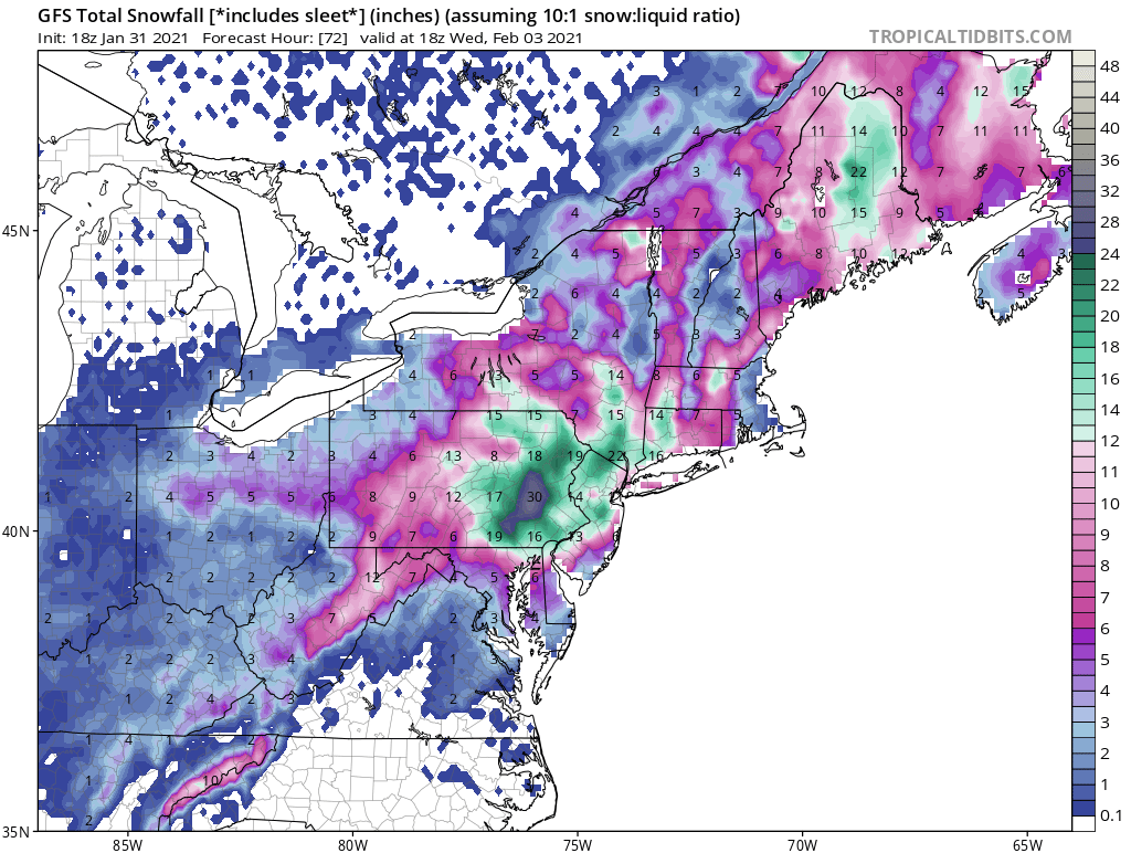
Question - we have three results - one that spreads more snow to the nw and cuts our totals down in Lanco, while we have the jackpot thru lancaster and another one showing the whole area getting hit. I guess we need to wait for all the models agree or are there any thoughts on which way this could go. More confluence = more outside, less confluence = more inside? BTW it has been a record setting number of days w/o measurable so the fact that it is snowing today and Wed/Thurs leaves me giddy with joy. Just wondering others thoughts.
-
Snowing here in lititz. Not sticking yet but nice to see the change.
-
This week would be quite the way to end our record number of days of no measurable snow. Bring it home. Btw i think on the euro im just to the left of the 23.3 inches in lanco. Woot.
-
6 minutes ago, paweather said:
I’m not sure what you mean?
More taint for us SE crew. Still nice hit but the lower snow totals are creeping towards us. I hope psuhoffman is right and this is just model mirage. Per the 18z gfs the low is going over nj now.
-
Light snow in Lititz. Glorious!
-
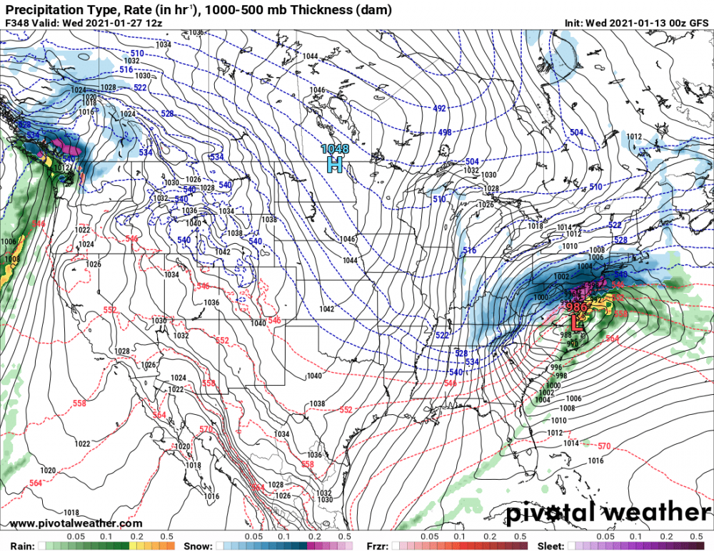
I think CTP summed up all our options pretty well this coming weekend. Basically a tossup. Let us hope we can get the most favorable outcome for us and perhaps as mentioned below a negative NAO? We can only hope.

There is considerable uncertainty with next weekend`s weather.
The GFS and GEFS have been consistent for the last several runs
with bringing a coastal storm up the East Coast Saturday-
Monday. Model runs have varied significantly in precip type and
location with outcomes ranging from widespread snow to all
rain. Meanwhile, the ECMWF has been more consistent in keeping
the surface low south and/or east of the Commonwealth with
basically no storm impacts whatsoever. The ECMWF instead favors
a deeper low pressure system over Canada, which would bring
prevailing southwesterly winds and dry conditions to the Middle
Atlantic region through the weekend. About all we can do at this
point is mention the possibility of *something* happening next
weekend, and as such, have brought in marginal PoPs to match WPC
guidance and lean toward GFS/GEFS solutions.

It is worth noting that the long range guidance from the GFS
shows the NAO dipping negative at the end of January...
something that has not happened since the end of November 2019.
-
1
-
-
9 minutes ago, canderson said:
That Lancaster county gradient is hilarious.
We believe in inclusion of all colors and bands for those who want to those who want not.
-
1
-
-
Mid atlantic forum getting excited for latter half of jan and beyond. And usually what they get the southern half and hopefully the entire area gets. Would be nice to move that ridge in the pacific over a bit east to allow us to be on the colder side of the boundary with a storm track se of us.
-
Beautiful winter day in Lititz PA. Looks like maybe we end up on the right side of the boundary later in the month hopefully. But will take what we can get.
-
3
-
 1
1
-


Central PA - Winter 2020/2021 Part 2
in Upstate New York/Pennsylvania
Posted
Crop it or reduce the resolution of your photo. Yeah the limit is 1.95 mb.