ForsythWx
-
Posts
113 -
Joined
-
Last visited
Content Type
Profiles
Blogs
Forums
American Weather
Media Demo
Store
Gallery
Posts posted by ForsythWx
-
-
Good clip coming down in Lewisville right now! 31, everything sticking
-
 2
2
-
-
Good clip coming down in Lewisville right now! 31, everything sticking
-
2
-
-
Huge, really cool looking, flakes near Clemmons right now. And sticking to everything
-
1
-
-
Finally transitioned to more snow than rain, really coming down in western Forsyth county.
Temp: 33
-
1
-
-
Rain/snow mix for quite some time now in western Forsyth county. 33-ish degrees
-
Road covered, cars covered, moderate snow in Advance.
-
1
-
-
00z 3k NAM has snow sticking around in Forsyth and Davie counties until after midnight ❄️ Nice dusting on roads already, still had residual ice from the last storm!
-
2
-
-
Light snow finally in Advance, NC. (Davie County)
-
1
-
-
1 minute ago, CentralNC said:
Problem is there will be a screwzone on the NW side of the precip due to dry air intrusion. It will be somewhere in the western piedmont I believe.
see the difference between 12z NAM and 18z? Things are looking better... cautiously optimistic.
-
2
-
 1
1
-
-
9 minutes ago, CentralNC said:
need to see some ground truth before I get too excited. mountains dont count lol
There have already been reports outside of the mountains of flurries / snow showers. And the snow blips on the radar are just getting bigger and moving east / NE. But I agree, my excitement for this whole event is pretty minimal for my county. Still cool to see and nowcast.
-
1
-
-
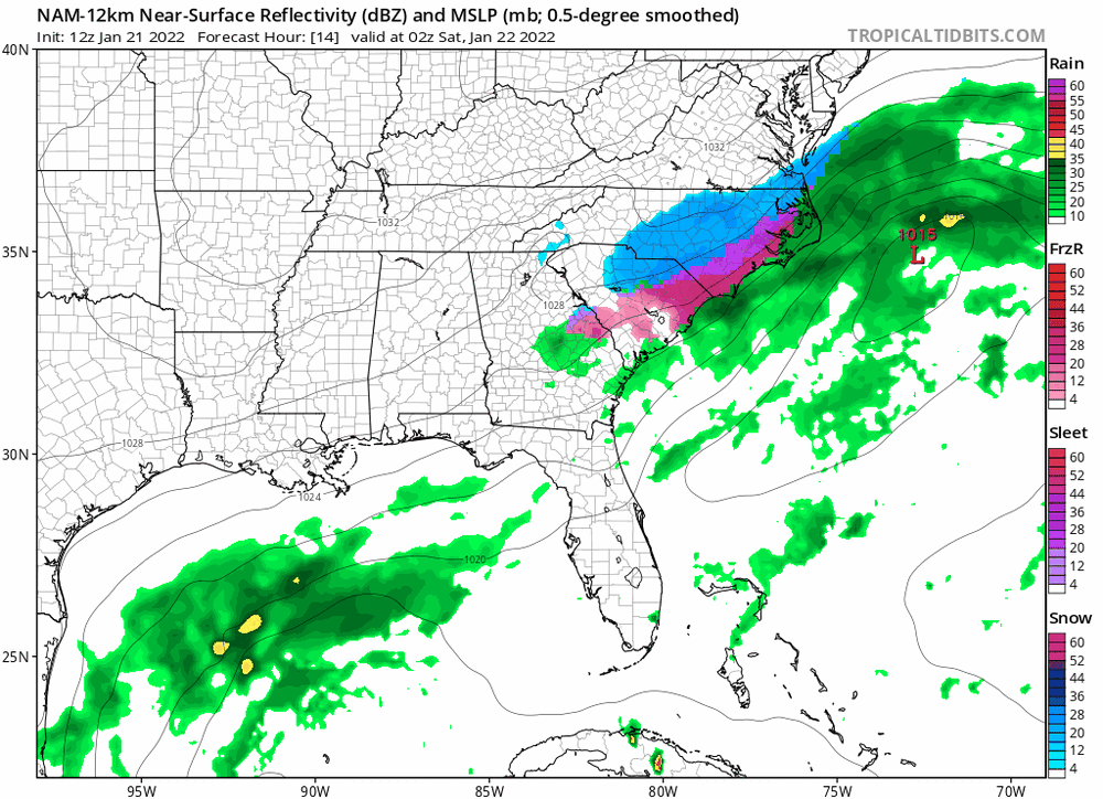
Radar quickly starting to light up south and west of Winston-Salem area.... interesting how much juicier radar looks compared to models at this time.
-
3
-
-
9 minutes ago, olafminesaw said:
The hires NAM reflectivity map looks great, but the precip map shows zero in the Triad. Will be fascinating to see how this plays out.
Opposite problem - but NAM also had snow showers and precip staying in the triad all night yesterday and I’m pretty sure I saw snow for 10 minutes. I’m not picking up what it’s putting down anymore for now.
-
Snow mixing in with the rain now in Clemmons (western Forsyth county)!
-
1
-
-
Hourly forecast (taken with a grain of salt of course) for western Forsyth county says rain will turn to snow ~ 3:00 pm today, has at least 40% chance through 11 pm. We will see!
-
3
-
-
As much as the NW side has fizzled out in the last few runs, don’t believe that’s impossible to undo. Especially with these same models that fail at consistency most of the time. Would I trust them showing a big storm 48 hours out? Probably not. Why trust the opposite? This seems to be a wonky timeframe for models anyway, in my limited experience.
-
4
-
 1
1
-
-
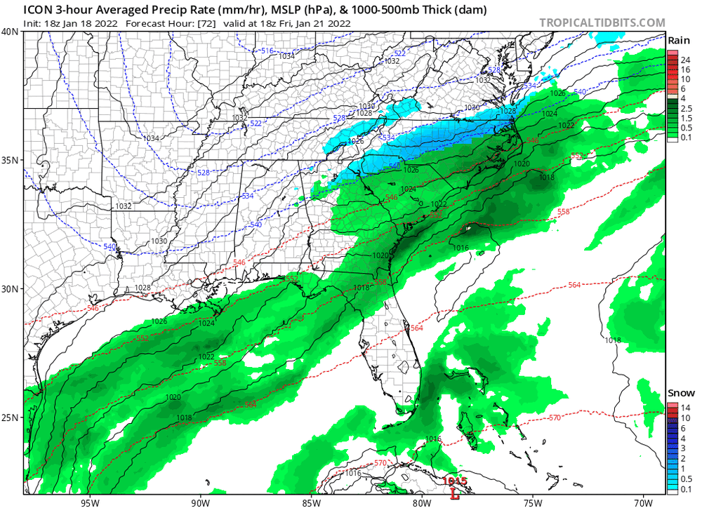
18z ICON doesn’t just look good for east of I-95...
-
2
-
 1
1
-
-
10 minutes ago, btownheel said:
Modeling says that block rotating through Charlotte fizzles before it gets over the Triad, hope it holds together.
.Interesting that the 18z 3k nam had it staying together through the triad... Hrrr vs Nam.
-
About 3.5 inches of sleet/snow in western Forsyth county. Wind is howling and roads are completely covered. 24 degrees... avoided freezing rain thus far
-
4
-
-
It’s snowing in Greenville. Pretty moderately.
-
Temp down to 37 in Greenville, falling relatively quickly.
-
Down to 46 in Greenville

-
I have no idea what’s coming from the sky at this point, but it’s coming down in western Forsyth
-
Pretty moderate mix coming down now in Lewisville. Wind blowing every direction
-
1 minute ago, WSchew said:
Radar is filling back in over Triad. Mix of very light rn/ip/sn starting to fall. Similar to 9-11am this morning, I expect some decent rates between 3-5pm but would be surprised to see any accumulation. I don’t see why RAH is holding onto WSW here, but here’s to hoping...
They claim that we will still see 1-2 inches between now and the end. At least as of an hour or 2 ago


Mid to Long Range Discussion ~ 2023
in Southeastern States
Posted
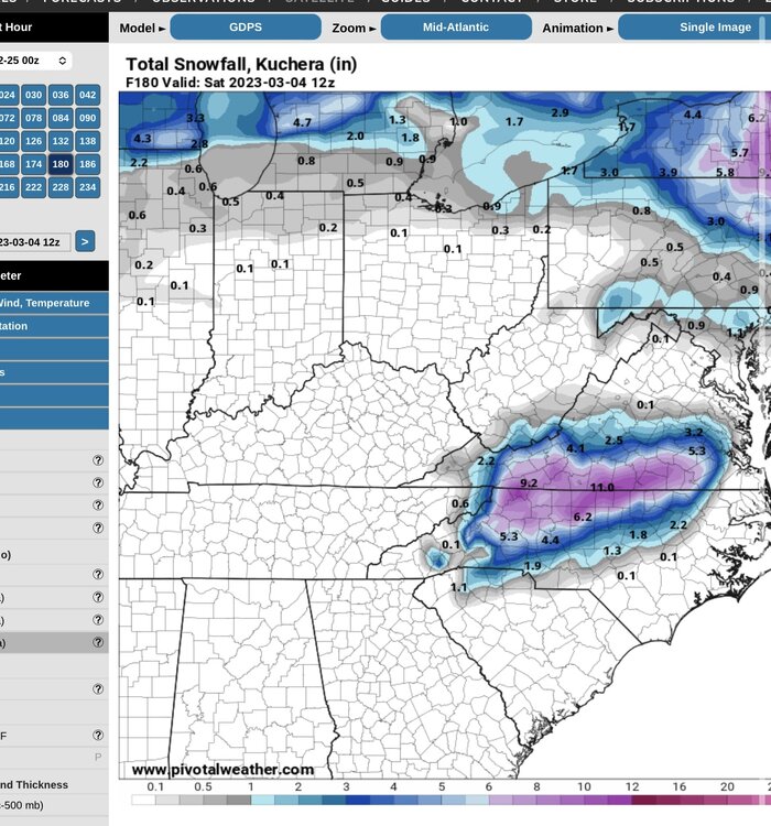
Eye candy on the Canadian tonight