

HeadInTheClouds
-
Posts
1,598 -
Joined
-
Last visited
Content Type
Profiles
Blogs
Forums
American Weather
Media Demo
Store
Gallery
Posts posted by HeadInTheClouds
-
-
This thing is booking.
-
 1
1
-
-
31 with light snow. Almost over here in Dutchess county. Picked up 2 inches. Never got into the heavier bands but something is better than nothing. 17.5 for the season.
-
2
-
-
NWS Albany finally did put the crack pipe down and lowered my forecast to 2-4.
-
2 minutes ago, cleetussnow said:
My point and click still has 7 to 13 in mid Westchester. Warning was lowered to 6. We won’t touch either. I suspect the update at like 3 am, waiting until the 0z suite rolls in to confirm everything.
They updated the forecast late this afternoon from 7-13 to 4-8 but nearly every piece of guidance shows barely anything. I think it's pretty obvious where this is going. I actually wouldn't be surprised if we got only a dusting. They also didn't update the briefing from 4:30am that shows Poughkeepsie area getting 8-12. It's just strange.
-
So I'm 20 miles north of 84 in western Dutchess county and NWS Albany still has a winter storm warning for a total of 4-8 inches. They also haven't updated a storm briefing from 4am today. Are they smoking something? I'm thinking 1-3/2-4 max . I would love to know what they are thinking.
-
1 minute ago, NEG NAO said:
8 -12 is now south of 78
Big changes today.
-
11 minutes ago, SBUWX23 said:
I think people are gonna like the 00z euro.
I don't, lol. I thought it was a lock to see 8-12 a little north of 84, now it looks 4-8. Maybe.
-
3 minutes ago, NEG NAO said:
are they even considering global models as of now? The mesoscale models are in range
You think they are going to disregard globals such as GFS, Euro, CMC and just look at mesos? No way.
-
-
00z runs will be interesting. I'm always leery of off hour runs.
-
Not every model run is going to be exactly the same. I see no real difference except 12z nam is a little west with the low and GFS a tad east.
-
6 minutes ago, NEG NAO said:
NAM stayed south and GFS shifted south along with its Ensembles - waiting on 12Z EURO
Where exactly?


-
Just now, Metasequoia said:
TWT has always been about grabbing eyeballs, as one would expect from a company, for good or bad. Less so about their actual forecasts.
This is true but they are in the business of accurate forecasts. Haven't watched that channel in years.
-
1
-
-
Where is the south shift that some speak of? I see none of this at 12z.
-
7 minutes ago, MJO812 said:
Interesting

CMC has been abysmal with this storm. Ens prob above gives NYC metro nearly 100% of >1 but gives places south of Albany less chance. Not going to happen.
-
3 minutes ago, MJO812 said:
I woke up to see the ukie. Now I'm done.

See you after the Euro.
-
1
-
 5
5
-
-
7 minutes ago, NEG NAO said:
its holding hands right now with the NAM
Seems like even the nam is based more in reality than the CMC.
-
Losing a lot of respect for the CMC with this one. It's either going to pull off a major coup or it's been just absolutely awful with this one.
-
1
-
-
WSW posted for 6-9 inches in MHV and NW Ct.
-
It doesn't look good but it's still not over for NYC metro. Maybe 1-3. Still no consensus among models. It's basically Euro/GFS/ICON vs CMC/NAM/Ukie.
-
3 minutes ago, NEG NAO said:
looking down the road to next weekend there will be no suppression and the rain/snow line uncomfortably close

Yea and you are talking about the GFS 190 hours out. These models are still trying to figure out this upcoming event less than 72 hours out.
-
1
-
-
7 minutes ago, Blizzard-on-GFS said:
Yes, slightly but the whole idea that this is going to be nothing but rain for odd 95 is definitely a doomer attitude. This is legitimate threat for I 95.
It is yes, but it did come north at least 50 miles with precip field.
-
2 minutes ago, Blizzard-on-GFS said:
Well, well well, the “it’s going to trend north Crew” is in shambles right now lol.
It did come north at 18z FWIW.
-
33 with moderate snow, around a half inch.
3k.png.4e06b11e3963d8a169cb5a8418ed6ed7.png)

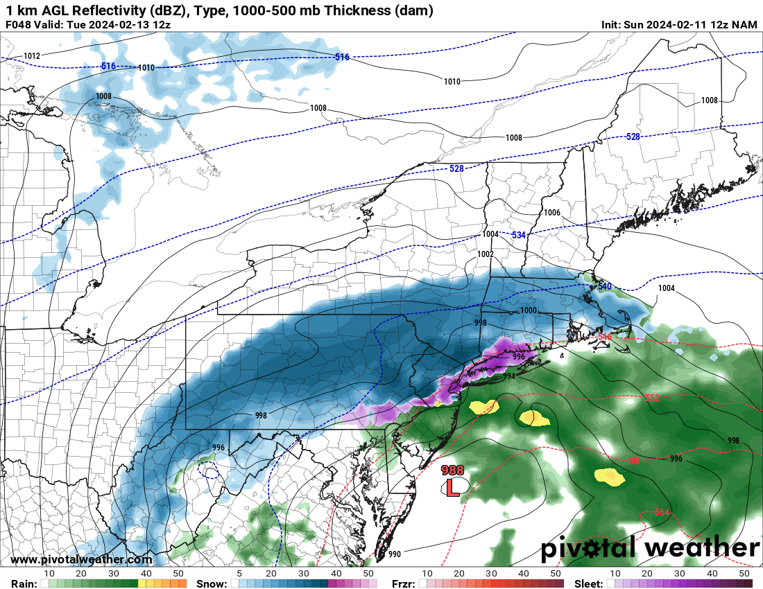
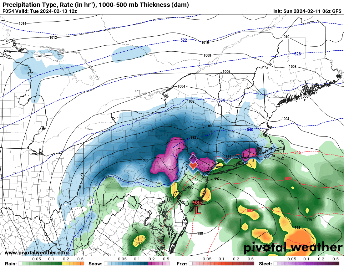
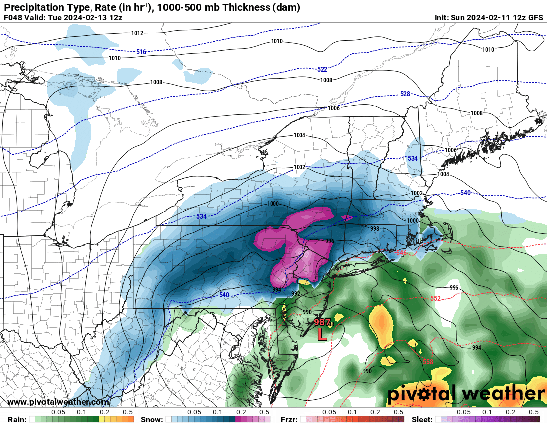


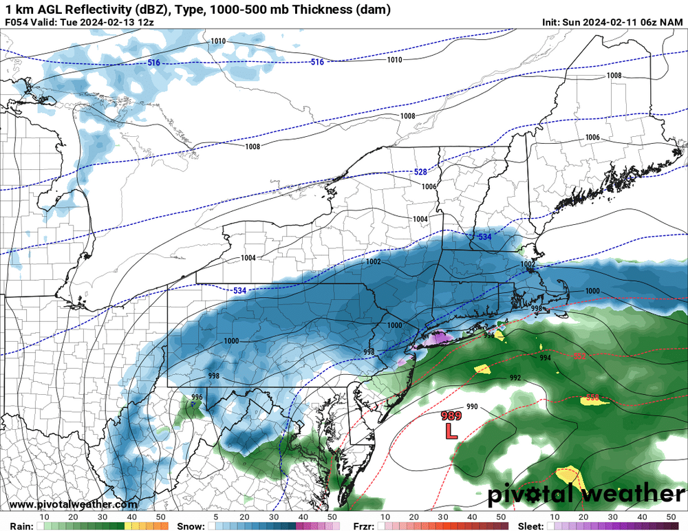
2/13 Significant/Major Winter Storm Discussion & Observations
in New York City Metro
Posted
@CPcantmeasuresnow