

kvegas-wx
-
Posts
2,073 -
Joined
-
Last visited
Content Type
Profiles
Blogs
Forums
American Weather
Media Demo
Store
Gallery
Posts posted by kvegas-wx
-
-
2 minutes ago, Superstorm93 said:
Full GFS track. I really hope we see this shift west tomorrow.
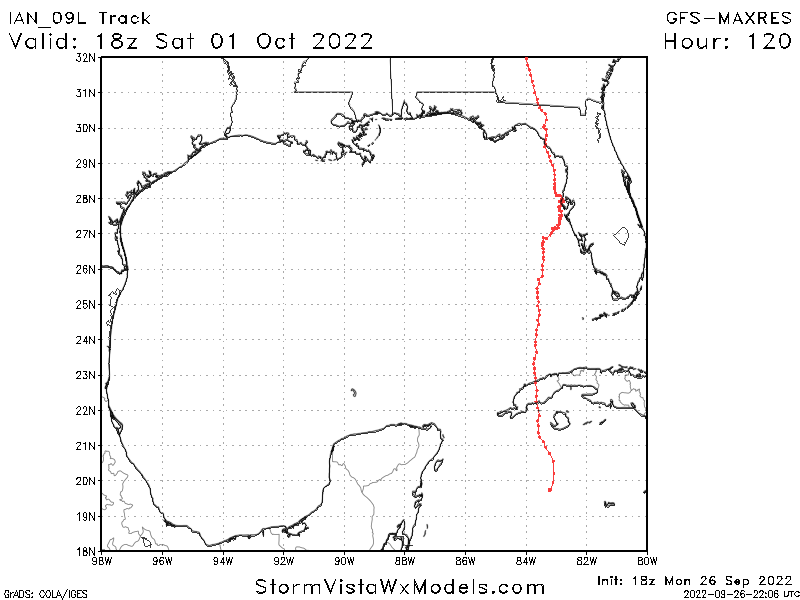
Why would this be drawn back west headed into GA? Seems a bit odd.
-
2 minutes ago, GaWx said:
12Z UKMET has a later landfall near Charleston, SC as per the dark blue line in this:
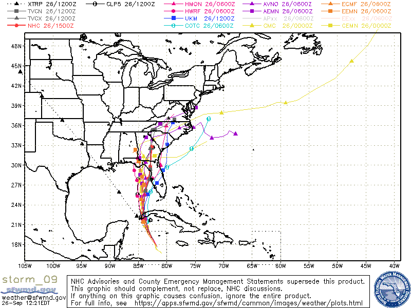
Anything left of Ian that transverses FL will get obliterated in the Atlantic with all this dry/cool air continuing to push thru the southeast. Not much worry about a second landfall IMO.
Note, please find a blue shed near TPA on google maps. That is our LF. We all need another legacy moment with JP's narraration.

-
The towing business in and around TPA has gone into freakout mode. Good luck finding a way to relocate your winter RV in the next 48 hours.
-
Seeing me a couple of 59s on the weekend forecast at the farm in Stuart. I'll take any hint of fall I can get.
-
 1
1
-
-
Seeing a nice 80° and partly sunny in the foothills on the 10 day outlook. That would be a welcome break from this madness. I'm counting the hours to September at this point.
-
2
-
-
Pouring graupel in Kernersville. One last gasp for winter.
Wind is roaring loudly just above the tree line.
-
Looks like a rain/snow mix on the cameras at the farm in Stuart this morning. Really needed a sunny day in the 50s today to do some ground prep for the season.
-
57 minutes ago, jlewis1111 said:

That would be perfect timing for spring Fescue planting!
#winteraintover #itsnowsinmarch
-
1
-
-
Ground is covered and still snowing at the farm in Stuart VA. Daughter says she is driving thru a heavy snow shower west of Winston on I40. Maybe a few token flakes headed thru the Triad shortly.
-
1
-
-
Just now, CentralNC said:
31 and zr here in Lewisville. Numerous reports of accidents
Traffic maps are quickly going red all over Winston and North on 52.
-
1
-
-
2 hours ago, Sandstorm94 said:
Please Lord let all of us get snow on Valentines so we can all have a special moment with our significant others... Amen
Sent from my SM-S115DL using Tapatalk
I look at it the other way around, a big VD snow means I aint gotta take her out and she can cook me a big ole sketti dinner. I will build the fire though.

-
4
-
 3
3
-
-
Is it ok to point out that my Bengals beat Oakland....we got snow. They beat the Titans.....we got snow. So I'm really liking these day 6/7 trends so we can win the AFC next weekend! Who-Dey!!!
-
3
-
-
I have always, always, always wanted to blow snow off my driveway with a leaf blower. Mission accomplished!!
-
7
-
2
-
 3
3
-
-
Very surprised at the lack of any 6+ inch reports from Roxboro out to the coast. I figured there would be several this morning. How about our Norfolk peeps?
-
Last few flakes here in the triad. Maybe a solid .5 to .75 inch. Hard to tell, this stuff blows around with the slightest wind. Total Colorado powder.
Anyway, radar is absolutely loaded for those out east. You guys are going to crush it tonight. Get out there and enjoy it!
-
2
-
-
Just drove down I40 west thru GSO by PTI and the snow is so powdery that it almost creates a whiteout when the cars kick it up. Just a dusting all thru the Triad, but the roads will indeed deteriorate quickly after another 30 minutes or so.
-
3
-
-
Heavy virga here in the uber-dry triad. Enjoy whatever you can muster triangle peeps.
-
6
-
1
-
-
42 minutes ago, CentralNC said:
need to see some ground truth before I get too excited. mountains dont count lol
Wont be any. With this rather light and short lived precip the DPs just wont climb fast enough across the triad area.
Not saying we wont see any snow here, just not enough time for anything more than a dusting. Definitely losing some to virga.
-
3
-
-
Gulf tap looks anemic IMO. Expected more coming with this storm. Gonna need some Atlantic action to make this a reality for anyone west of the Triangle. It is D.R.Y. outside. DPs nearly falling into the single digits now.
-
Unfortunately I think the story here in the Triad tomorrow morning will be black ice. And I mean bad. All the brine washed off today and now the streets are still soaked with temps dropping below freezing and into the 20s now. Body shop bonanza coming up!
-
1
-
-
100% snow burst here in Kvegas. Pretty close to ripping fatties. Won't last long looking at radar.
-
2
-
-
Very quickly sliding down towards the mid 30s in the Triad this afternoon. I'll guess 35° or so by 5pm. Seeing 38° at the farm in Stuart just across the Va border. Dropped 3° in the last couple of hours. Bad part, cold chasing moisture on the Fropa. Not sure any of it is going to catch up.
-
1
-
-
31 minutes ago, Justicebork said:
Is this board a better study in psychology or meteorology?
Quantum Super Computing
-
2
-
6
-
-
14 minutes ago, burgertime said:
Hmmm... this was the 00z run from last night. So maybe he's on to something here.
Later than modeled, yes. But the temps are starting to dive quickly coming through middle VA and down into the foothills areas. It's coming. Even my local point and click here in the Triad didn't have us flipping to snow until this evening (if we get any snow).
EDIT - GFS looks pretty much exactly like what is happening over the next 6 hours or so to me. Would be all snow across the northern tier of NC by 7pm assuming we have any precip left.
-
1
-
Hurricane Ian
in Tropical Headquarters
Posted
Apologies, I thought all the tracks earlier today that were showing a second landfall and eastern NC run were because the HP was retreating and allowing Ian to escape.