

Thinksnow18
-
Posts
4,144 -
Joined
-
Last visited
Content Type
Profiles
Blogs
Forums
American Weather
Media Demo
Store
Gallery
Posts posted by Thinksnow18
-
-
30 minutes ago, BuffaloWeather said:

Ok that’s just plain weird
-
 1
1
-
 1
1
-
-
41 minutes ago, BuffaloWeather said:

TWC has 80’s for Tuesday, Wednesday and Thursday next week
-
1
-
-
On 5/2/2022 at 10:00 AM, Flying MXZ said:
Wow, didn't realize it was that "cold". At least the worst month of the year is over.
Isn’t is funny that suddenly KBUF and KSYR are now in the same ballpark as KROC and KART?
-
21 hours ago, BuffaloWeather said:
Holiday valley

That actually looks mid-winter
-
I think it’s hilarious that ALL modeling has come in underdone and no one wants to fix it. It’s been snowing in Williamsville since 3 and ellicotville has about 3” otg yet somehow NO ADVISORY for the southern tier!
-
1
-
-
Already mixing with snow in Williamsville. Temp 40
-
1
-
-
On 4/17/2022 at 2:04 PM, 96blizz said:
Euro is definitely further NW…

So my question is, why Cleveland, at a lower level than KBUF is in the 5” range and NF dusting? Dynamics are there and timing is right with overnight precip.
-
1
-
-
20 hours ago, BuffaloWeather said:
Join the discord Dave we got the whole crew there now.
I tried to join but Captcha kept repeating and not letting me past that point. Tried four times…pretty sure I’m human…
-
23 minutes ago, BuffaloWeather said:
Over 40" in the mountains of ADK


More importantly what does Kuchera say???
-
2
-
-
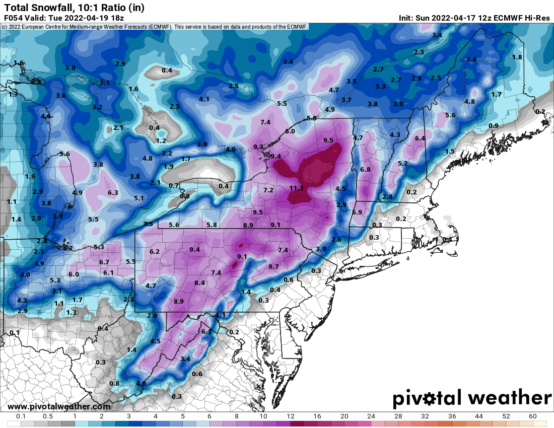
Looks like the 6z GFS wants to keep winter around periodically through months end…
-
2 hours ago, TugHillMatt said:
Shocking. It's going to do what it's done for the past several years. Go from late winter to months of 90 degrees.
This. It’s the new norm. I’m certain there isn’t much forecast skill or true modeling this far out, but what other anomaly would it be? 10 months out of each year now are AN with 2 BN. On a side note, end of April does look cold (relatively speaking)
-
3 hours ago, BuffaloWeather said:
Next week looks very warm. I bet someone hits 75-80 sometime between Tues-Thurs

Sizzlecuse. All. Day. Long.
-
1
-
 1
1
-
-
9 hours ago, BuffaloWeather said:
Don't think I posted the March temps
BUF: +4.2
ROC: +2.2
WAT: +2.8
SYR: +3.2
BING: +2.6Really I have to ask, I know the department of redundancy department, 2 degrees warmer just 60 miles away? From the FWIW department, the eastern end of Lake Erie is full of ice and 32 degrees…yet somehow…
-
14 hours ago, BuffaloWeather said:
High of 23 today at KBUF, normal high is 46.
Low of 17, normal is 30.
Crazy airmass. Also pretty sure KBUF made it to their snowfall average today.
That’s not a “thanks” emoji that’s a championship emoji…GSB W
-
1
-
-
19 hours ago, BuffaloWeather said:
I’m calling for 12 straight 90 degree days in July

Yes…in Boca Raton…
-
2
-
-
2 minutes ago, LakeEffectKing said:
Snow has pretty much stopped ended up with about 14" overnight.
Travelled through this last night on way home with family from Orangeburg NY. 81 N about 45 miles south of Syracuse, right through the city then about 35 east on 90 was a mitigated disaster. Cars literally stopped in lanes of traffic on 81 N causing ridiculous delays and treacherous roads made it that much worse. Pretty sure at one point it was 3-4” hour rates, pitch dark and in the hills.
-
1
-
-
2 minutes ago, vortmax said:
Is Winter really over?

Just going to comment. Looks like chances right into the first full week of April. We should be used to this by now though. It’s been this way for the past 5 or so years
-
2
-
-
1 hour ago, CNY_WX said:
Can KSYR hit 80?
Fixed it
-
3
-
-
1 hour ago, wolfie09 said:
As of right now CPC going with"near normal" probabilities, could go either way lol
.thumb.gif.f1676bbea6ceaa467bd0b8d595e1fc15.gif)
I would tend to believe in 2 days that outlook will be solid blue over the Great Lakes and North East. Could be pretty cold too as those anomalies on the euro and gfs would have temps in the 30’s.
-
1
-
-
So the 18z GFS continued the colder look by months end and doubled down. Rather wintry look.
-
1
-
-
4.9” in Williamsville. Right in line with projections.
-
1
-
-
7 minutes ago, SouthBuffaloSteve said:
agreed, looks like our best chance is actually 6pm Friday - 6am Saturday. p type and how fast until it can start to accumulate will be the key.
I think with ratios, especially Friday night-early Saturday is when we’ll see our best accumulation.
-
8 minutes ago, ChalkHillSnowNut said:
Little too early for HRRR-go with the NAM…?
NAM seems to have gone rogue with the Far East solution…my thoughts are the overrunning event Friday night had more juice than previously modeled
-
1
-
-
36 minutes ago, wolfie09 said:
Hrrr0z

Seems like the models are adding more QPF back west towards WNY. Each model has raised the amounts an 1” or 2. Most now show a 4-6” swath or more.
-
2
-


.gif.0eee0b0521c21b76e1067db74516cf4e.gif)

Upstate/Eastern New York-Springtime?
in Upstate New York/Pennsylvania
Posted
Which I hope doesn’t translate to July 5 days in a row of 71, 69, 70, 70 and 71 with 4 of the 5 days rain