

Coach B
-
Posts
256 -
Joined
-
Last visited
Content Type
Profiles
Blogs
Forums
American Weather
Media Demo
Store
Gallery
Posts posted by Coach B
-
-
1 hour ago, weathertree4u said:
Nashville is now in fourth place for greatest number of days without at least a trace snow, seven hundred fifty days I think
I think you may mean days since Nashville has had greater than 1" of snow. We've had snow in most every winter month since then, but they have been Trace amounts or minor measureable accumulations.
-
45 minutes ago, Carvers Gap said:
12z GFS with some wildness. LOL. New storm on Wednesday. Crusher for M TN after that. Something for everyone.
Gets even better out in fantasy land with a Deep South slider and an end of run arctic blast that provides a state wide snowfall. If only.......
-
 4
4
-
-
14 minutes ago, tennvolfan said:
I’ve noticed an overall uptick in late winter events around here......Pre 2000, I would never have believed that late winter would produce without producing in January- but it appears it’s more likely now. I can’t find any records in this area that late winter events happened after nothing earlier. Maybe it’s a new precedent in this late phase positive AMO. I think the AMO needs to flip to see where the cards fall. We are nearly 25 years into the positive phase so it’s time is limited.
No doubt that it seems late winter has been producing better than mid winter for the last decade or so. Maybe the lengthening wavelengths negate whatever pattern/climate problems or bad luck we've had in the heart of winter. I was mostly lamenting that 13-14 and 14-15 had the potential to bust the area out of the long term snow drought. Nashville is way overdue a 20"+ year, or at least a couple of 15" years in a row. You can't convince me that at least some of it isn't bad luck because places in all directions have had some big years in the last decade.
-
1
-
-
5 minutes ago, Carvers Gap said:
In NE TN, we have had some really good winters during the last 15 years and some not so good ones for sure. 13-14 and 14-15 were really good. 09-10 were really good. 14-15 is the most snow I have ever seen in Kingsport during a winter. ........ We will see where February goes.
I wish you hadn't mentioned 13-14 and 14-15. I've tried to banish them from my memory. That was a great time to bust out of the long term snow drought, but SW and most of middle TN managed to screw up even in those cold years with some great patterns.

Agreed on the wait and see for February. The clock is ticking, but we still have time to salvage a solid week or two of real winter in there somewhere.
-
Good stuff Holston. We're even getting a few flakes here in southern middle TN. Very light snow and 19.
-
1
-
-
32 minutes ago, John1122 said:
We simply lived in a colder environment then for whatever reason. It was the same environment that made me excited when Margie Ison said "Alberta Clipper'. That meant 3-5 inches of snow and no school. Now clippers are rare, half the time they produce WAA and rain or nothing here and mainly produce snow over the upper midwest and Ohio Valley. One thing about it after this year, the 1991-2020 30 year normals will make it harder to be AN temp wise and BN snow wise.
I agree. I've been going back through the historical NOW data for Jan and Feb when I have time the last several days. As Carver's has pointed out, it was just much colder with more snow from 1960 thru about 1985. People who grew up in that era in TN say things like, "we used to get at least a couple 2-4" snows every year, and they hung around for a week or more." They were generally right, even for non elevated areas throughout the state. The number of days with snow cover for Nashville in the winters of 1977-1979 alone is astounding compared to now. I didn't even look at the 60s, as I'm sure they were similar. Sometime around 86 that changed. I think some big events for the following 15 years or so kind of masked the change. We had the slider in 88, the Superstorm in 93, the massive ice storm in 94, big events in otherwise not really cold years in 96 and 98 and so on. Interestingly, as has been pointed out by others, the 1920s thru the 1950s stunk for winter as well, so a decades long bad stretch cannot be fully blamed on man made GW. It's pretty neat to dig back into the historical record. So its my hope that we shift back into a more favorable period before I get to old to enjoy it!
")
-
6
-
-
Wow! A real life +PNA and cold that does not look especially transient, right in the heart of peak winter weather climo. We won't know what to do with ourselves if that look holds.
-
4
-
-
06Z GFS flips to full on winter for all of us starting a week from today. Pretty cold look with multiple chances for wintry. I would guess its likely not accurate with the lasting flip to cold throughout the run. But I'm sure feeling better about the pattern reshuffling in a week or so.
-
5
-
-
1 minute ago, John1122 said:
OHX disco is basically, several factors suggest heavy snow possible, several factors suggest less snow possible, we're not sure what is going to happen, so we're going down the middle.
Its really hard to fault anything mentioned in the afternoon AFDs. HUN's disco was a little more informative:
QuoteTaking a look at cross sections and determining deformation zones, there is a period of time where enhanced lift at 700mb occurs overhead, and therefore may enhance snowfall rates tomorrow evening. Though this is a small ~3 hour window, this may lead to higher snowfall rates for a few select locations across the area. Overall, snowfall totals look to be around a dusting to half an inch in NW AL and Srn Middle TN, dwindling as you head to the South/East. A few spots in Nrn areas may receive up to 1", which is Winter Weather Advisory Criteria for our office. For now, will not officially be issuing that just yet, and will allow one more run of the models to come in for the midnight shift to officially decide to pull the trigger. Confidence is not high enough at this point today to issue that product this far out. Assuming we get a little deformation banding setting up, realistically, we could see 1-1.5" in some spots, if not a little higher. Some short-term models have gone with MUCH higher amounts, but am not biting on that given the current atmospheric profiles in place.
-
 1
1
-
-
Lots of 12-14 readings in rural middle and west TN this morning. Impressive!
-
15 hours ago, John1122 said:
No November day will top November 25th, 1950. High 8, low -7 here. 8 inches of snow on the ground. It was -8 in Allardt that morning. Which may be the all time record low for November in Tennessee since a lot of stations weren't up back then. It was also -7 in Jamestown that morning and -6 in Monteagle.
Holy cow! I don't remember ever looking at this one. Even Nashville had 9.2" and a low of -1.
edit: after looking at I realized that is the Great Appalachian Storm of 1950. Didn't realize that it affected mid-TN as well.
-
2
-
-
Significant inversion this morning. I was up in the 40s on the hill at the house, but noticed a solid frost down in the fields on the way to town.
-
4
-
-
8 hours ago, John1122 said:
This year is probably the most mornings in the 32-36 range without going well below 32 in a while. Seems like the past several years just went from 40s to a hard freeze with no middle ground.
Yep, we've had at least four or five mornings with scattered frost already but nothing below freezing.
-
I don't know if any of you follow Crankyweatherguy. He's New England focused but puts out some pretty good stuff. From what I can surmise he thinks deep winter hits all at once this year for a four to six week period(with no reloads) beginning around mid January followed by a normal spring by the first of March. Says we are in our "January Thaw" right now.
QuoteWhen we look at the major hit the stratosphere looks to be taking it is entirely possible we see an event where the vortex is completely broken down and we get our dam burst now and all at once.
If so it rarely if ever reconstitutes into another viable entity that suffers another break down and an extension of winter (aka late winter weather into March and April) as we've seen more of in recent years.
I think there are plenty of signs to suggest we're about to see the major event and then that sends us into a rather unbroken six week or so period of winter weather events.
If so then there's no interludge midway, no pattern reload that then comes back, and instead you get it all in one string and then Spring arrives on schedule with no late period surprises.
It has been a while since we've had a winter go like that and there are some things here to suggest maybe that's just what we get.-
5
-
2
-
-
Where do you guys think would be some good places to chase snow in TN? Although I'm several years away from retirement, one of my daydreams is to be able to model watch then rent a State Park cabin or airbnb at the last minute and ride out a nice storm or NWFS event. Obviously the exact location would depend on the storm, but getting up as high as you can in elevation is almost always going to help. I'm thinking the Roan Mountain area or somewhere on the upper Plateau. If nothing else this will provide some good map study for those geography nerds among us.
-
Anybody know or have a link to the MRX CWA snowfall totals for the storm?
-
4 minutes ago, PowellVolz said:
Geez that’s beautiful
.It really is. This is the neatest thing Ive seen all week. Oh, and Nashville really is down in a hole. UHI and elevation really screw things up for them. OHX has more elevation to consider than we often think about. Lots of areas in southern middle TN over 1000 feet that doesn't seem to be mentioned either.
-
21 minutes ago, Holston_River_Rambler said:
Found this topography map of east TN with some...unique...coloring that really helps identify that zone around Morristown where the elevation kicks up. Really seems to coincide with what some of the models are showing as the transition zone. Am interested to see how the actual rain/snow line verifies.
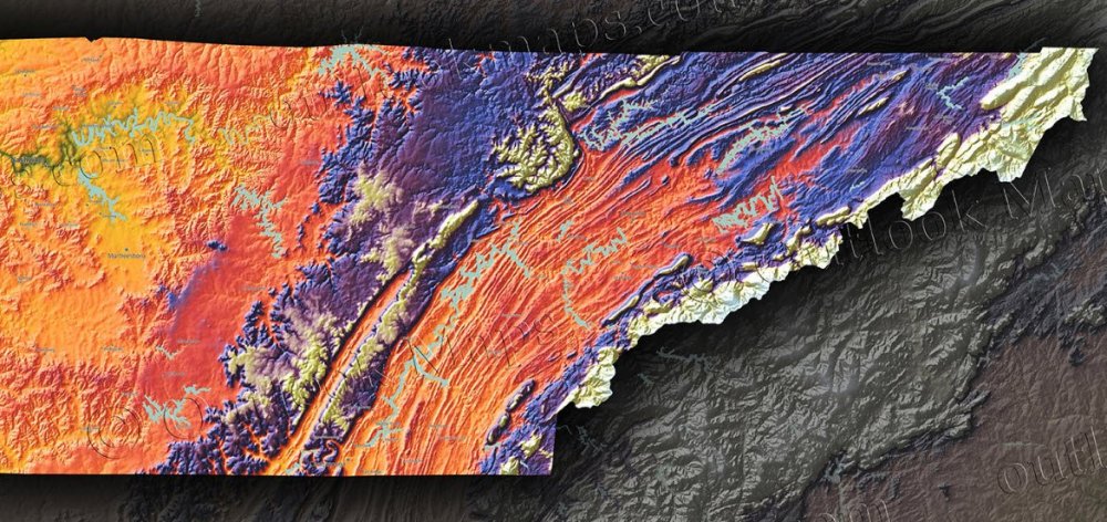
That is cool! You have a link to that for the rest of the state?
-
So while the trailing 850 low is actually extending snow/precip chances back this way its also screwing up the thermals? In other words, the thermals are not as clear cut like a consolidated low pressure system would be?
-
16 minutes ago, TellicoWx said:
Big improvement in the 850s as the comma comes overhead in East TN. Also, increased the precip rates which may translate to the surface better.


Look at the warm nose into middle TN/S KY! Dang, I hate to waste a chance at a system taking what would ordinarily be a perfect track. I really cant figure a warm nose like that with the LP over Jacksonville?? Why the heck are the 850s not dropping when it goes by to the south?
-
1
-
-
9 minutes ago, tnweathernut said:
Good update, Carvers.
FV3 should be further north with more GOM ridging, less confluence in the northeast and a weaker vort around the MN region at hour 96. If it would ever update we likely won't see the TN Valley crusher we saw at 6z. Still a long way to go. Euro............... you're up!
Spot on! The FV3 shifts the heaviest axis of snow to 40 north and Plateau/Mtns. Man, if we were getting this track in January we would be golden statewide!
-
1
-
-
That FV3 is about the only thing that really likes south of 40 in TN. I won't totally give up hope as long as that low tracks down towards the Gulf coast.
-
6 hours ago, mississaugasnow said:
How does Nashville handle snow? Coming down this Thursday-Sunday for the Thursday night football game followed by spending the weekend seeing the city. Sorry to go off topic. It would be pretty funny if I came down from the Toronto area and while here see my biggest snowstorm of the year. Biggest storm for Toronto this year has been 4"
Nashville handles snow pretty well if you are patient. Tennessee actually uses plows and pretreats roadways with brine and salt. In my experience it's much better than the states to our south which apparently budget next to nothing for snow removal. That said, it won't be anything like removal in Toronto. We really only work the major roads and interstates.
Nashville is far enough north to get some snow every year, but they'll get pretty wound up for the first one. If we are lucky enough to have a winter with multiple significant winter events they'll be complaining about it just like the Yanks.
-
2
-
-
7 hours ago, Carvers Gap said:
Don Sutherland, who I respect quite a bit, also released his winter forecast on the main forum. For those who missed it like I did...here is the link.
Don has done some really good work in the past. If I remember correctly, he's not prone to hyping cold and even been more negative than most at times. For this year he's giving double weight to 78, 03, and 2010 in his analogs, so that's being pretty positive about snow and cold. He even throws a bone our way by including Nashville and Atlanta in his snowfall predictions. His total for Nashville was not all that impressive(5-15"), but considering how our 30 year snow drought has tanked the average, not surprising.
-
3
-


Andre Michaux Feb 1796 analogue Storm
in Tennessee Valley
Posted
I just measured 1.6" on the snowboard here southwest of Lewisburg. Slept through the whole thing.