

Coach B
-
Posts
256 -
Joined
-
Last visited
Content Type
Profiles
Blogs
Forums
American Weather
Media Demo
Store
Gallery
Posts posted by Coach B
-
-
24 minutes ago, jaxjagman said:
Guess ill give up on the MJO being more adavanced,it dont seem to have much support,the next 10 days the Euro ensembles are pretty much bunched up into the WP
.thumb.png.aa62d51dd84549f4b2b4d6b72be774c7.png)
Have I read that phase 7 in February is actually pretty decent for se snowstorms? Maybe that's just for the east coast?
-
Tough morning to forecast temps. My low was 19 here on the hill, but there are near 0 readings within just a couple of miles.
-
 1
1
-
-
The NWS coop site less than two miles away was at -13 at 6am. There were several -15 readings around on personal weather stations.
-
1
-
-
58 minutes ago, *Flash* said:
I want to buy this, but not so sure ATM. Gut says he’s downplaying southern/SE middle and overdoing metro Nash.
He's a retired meteorologist from OHX so he's probably as good as anyone.
-
4
-
-
6 minutes ago, PowellVolz said:
You have that?
.
-
4
-
-
3 minutes ago, John1122 said:
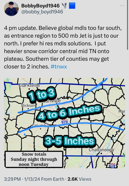
I assume that all modeling must be verifying too cold lately. MRX states it's confident highs will be in the 30s on Monday and has my high at 34 degrees in the point forecast. No model besides the Canadian has me out of the 20s on Monday. Their current call is for the highest totals to be around 2 inches on the Northern Plateau and SWVA areas that border Kentucky. I guess the Euro spooked them. My forecast did change from snow showers wording to just snow wording. Which signifies confidence of a steady snow event in my experience. They did earlier discuss only issuing WWA advisory products for this event and with new criteria for warnings going down from 4 inches to 3 inches, them saying 2 inches makes sense.
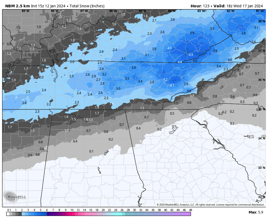
Maybe going with a NBM approach? That seems common from WFOs at this range. NBM has always seemed very conservative to me for a supposedly blended model.
-
4
-
-
24 minutes ago, John1122 said:
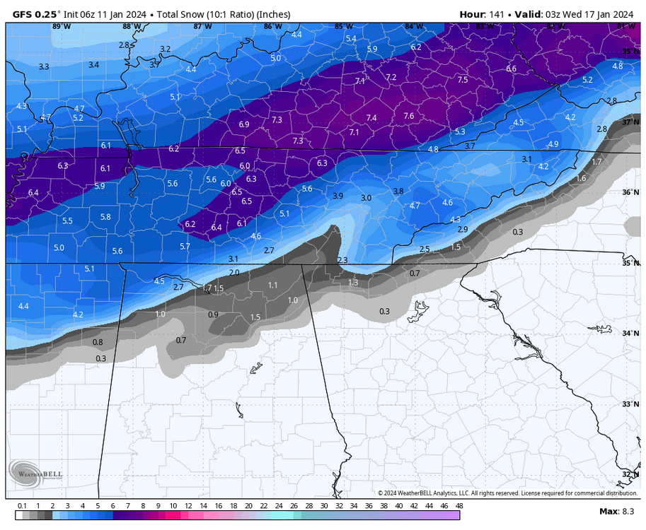
Huge improvement on the 06z GFS vs the 00z.
It likes all of Tennessee.
-
1
-
-
3 hours ago, John1122 said:
Weird turn on the Euro as it just keeps light snow over the area for 12 hours longer than the other models and we get a couple inches that way in the eastern half of the area. Nashville and west still do okay there.
Looked like it was trying to transfer the energy over south middle and east TN to the coastal bomb. Is that the first time we've seen that look with this storm? Strange
-
4 hours ago, Holston_River_Rambler said:
How long has it been since we've had a system so strong its dynamics drove a change from rain to snow? I'm not talking about one of the "wave rides an arctic front" scenarios we've done pretty well with lately. I mean a big old bowling ball upper low rippin' fatties.
10 or 20 years?
March 1st, 2009 is the last biggie I remember. There were areas of 9-11 inches across southern middle Tennessee.
-
1
-
-
3 hours ago, Silas Lang said:
Man, why ain't more people posting? Was hoping to see some reports! Pics? Observations?
I'm close to mm 30 on I-65. Got about .1" of glaze on elevated surfaces here. Nothing on the roads best I can tell. Temp bottomed out at 29. Currently holding at 30. Curious to see how temps recover today and if there is some chance of a little more tomorrow morning.
-
5
-
-
3 minutes ago, *Flash* said:
Not at a place where I can check modeling. Is west/mid TN in play for the 25th?
At this point I'd say yes. GFS and Canadian cut the low right across TN while the Euro is down on the gulf. If we can split the difference we'll be golden.
")
-
2
-
-
40 minutes ago, John1122 said:
This is unique in my memory. I've never that I can recall been too far north for a clipper. Most clippers here you hope to stay cold enough for all snow if the moisture even reaches this far south. Looks like that band of 1.5 inches some models were showing may come to pass in parts of Central Knox.
It happens. I missed meaningful accums both to my north and south today. I'm saving my luck for a good one in late January.
-
3
-
-
33 minutes ago, Carvers Gap said:
Great points. I am going to run the fireplace wood stove insert today, though! Yeah, the RGEM/ Canadian combo have been good so far this winter.
Forgot to mention I lost power for three hours last night immediately after the front came through. Luckily the wood stove was cranking!
-
1
-
-
I'm at -2 with just a coating of snow along I-65 in Marshall county. RGEM and Canadian were spot on with my minimal accumulation.
I'm not sure this is one where you eastern guys can entirely blame the Plateau for the lack of snow. I think the dynamics and trajectory of the system were just yanking it to the northeast. I usually do pretty well compared to the Memphis to Nashville corridor even though I'm 50 miles south of Nashville. Not this time. My elevation, topography, and ruralness got me nothing.
-
3
-
 2
2
-
-
1 hour ago, Silas Lang said:
If I am remembering correctly, I think March is even typically better than December for snow.
Pretty sure you are correct. I know Nashville averages more snow in March than December. Obviously March is warmer, but its also prone to some big hitters with snow. December, seems to be more likely to have little nickel and dime events.
-
1 hour ago, John1122 said:
12Z GFS is full 1983. The December of ultimate frustration as Daniel noted. That year we'd get cutters, then ice box cold.
Ugggh..... Nashville only reached 40 degrees once during the 1983 holiday 9 day arctic plunge. You guessed it.... it rained over an inch that day and other than some token flakes/dustings it was basically bone dry and frigid the rest of the time. I think most of the state got a couple of events during January 84, but the repeated cold/cutter combo had to be painful during that period.
-
3
-
-
16 hours ago, Daniel Boone said:
I'm sure many on here notice, the first scattered Frost are never forecasted or mentioned as even a possibility. I don't quite understand that as If I were working with the NWS I would at least mention the possibility in mountain Valley's when conditions are like they've been the last few mornings.
Unfortunately, I think that's pretty normal. There is a large urban/rural split in many areas. Plus in much of middle and eastern TN topography as you mentioned is a huge variable, especially in regards to overnight lows during a dry fall. I'm in a hilly area in southern middle TN and commonly see 10 degree differences over just a couple of miles this time of year even in my mostly rural county. Our growing season is almost always over before we see the actual frost/freeze warnings.
-
2
-
-
1 minute ago, Carvers Gap said:
This is old school stuff. Get a nice coastal and then it snows for hours after as the moisture is just wrung out of the atmosphere.
Jackson, KY radar looks great upstream for you!
-
1
-
-
I measured 3" on the snowboard but got some 4-5" measurements in the yard. This is one where the patio table and back deck measurements will probably be especially high because of all the snow blowing off of the rooftops. OHX only measured 2.8" but lots of 4-5" reports around Nashville.
-
1
-
-
13 minutes ago, Uncle Nasty said:
Is it me or am I looking at the radar wrong? The precip shield rolling through from SW to NE looks like a typical frontal passage. Put in motion I don't see any pivot at all, it just slides west to east. Maybe my thinking was off when I thought the snow would be wrapping around more instead of sliding west to east, if that makes sense.
Sent from my moto z4 using Tapatalk
Anafrontal snow. I think we had about the same thing on January 3rd.
-
1
-
-
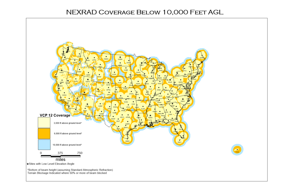
31 minutes ago, nrgjeff said:
Yeah radar misses Plateau upslope. Most of the cloud, at least the nucleation, is below the beam from any radar site.
Came across this online today:
-
1
-
6
-
-
Only had a dusting at the house, but it looked like half an inch just a couple miles away. HRRR and NAM 3K nailed the idea of minor accums from the streamers in middle TN.
-
4
-
-
44 minutes ago, Carvers Gap said:
January 84 is nearly a perfect analog.
@John1122anything spectacular in January/February of 84? I remember those months as being ho-hum...but I was young and could be wrong. It is triple weighted in yesterday's analog package.
The January 84 dates coincided with a 3.5" snow in Nashville that laid on the ground for over a week due to a major cold shot that included four days in a row with below 0 lows! The double weighted February 97 dates were nothing to write home about though.
-
2
-
-
1 hour ago, Carvers Gap said:
..... I will say this though as a counterbalance to that last opinion, February systems tend to over-perform in my book. Modeling often overestimates how far south those storms will be suppressed and underestimates the strength and precip.
....For you LR model watchers, does that pattern after the cutter look like a return of the current pattern or is it a new pattern? It looks to me like a variation of the same family of EPO ridges, but the center of the ridge looks further south than the previous pattern. The reason I ask, the current pattern is due to break 4-6 weeks after Jan 3. That would mean that look in the LR is very temporary. If it is a new-is pattern, we may see much of February get cold.
I did some rudimentary monthly snowfall numbers for Nashville several years ago. While January was the snowiest month, it was only a slight edge. So slight in fact, that if you divided the monthly average by the number of calendar days, that February actually averaged slightly more snow per day. It just likes to snow in February even though the average temp is going up and days are getting longer. I suspect it has to do with the longer wavelengths and slightly less chance of a cold and dry pattern.
As far as the LR pattern, I'll let those of you who know more break it down. However, to me it looks like the trough wants to set up a touch farther west, which should give us more chances than we've had this week. Question is, will it set up too far west and give us rainy cutters that benefit Oklahoma and Missouri, or potentially give us a shot at some over running wintry precip followed by serious cold.
-
3
-
1
-
.png.e993878dddc60194ae40eaca30dc175a.png)

February 2024 mid/ long range
in Tennessee Valley
Posted
Great, now you've added yet another thing to my "one day when I'm retired" day dream bucket list. I've already got trips in there for the Keweenaw Peninsula and the Tug Hill Plateau. I'm going to have to keep working longer to afford all these trips.