

PressureDrop2017
-
Posts
31 -
Joined
-
Last visited
Content Type
Profiles
Blogs
Forums
American Weather
Media Demo
Store
Gallery
Everything posted by PressureDrop2017
-
This was a brilliant parody of fake reporting of The Weather Channel, made by some locals https://www.youtube.com/watch?v=xDlzrwK5M6c
-
Another factor is this takes place in an atmosphere of general distrust of media, and now anything objectionable can simply be dismissed as "fake news" Plus, some outright frauds in the weather reporting, such as Mike Seidel, who actually did produce fake news, pretending that he can't stand up when others are walking casually in the background. And lying about the windspeed being 60 MPH when meanwhile it says on their own live broadcast that the speed is 29 MPH. That's not an exaggeration, it's an outright lie. The Weather Channel hasn't fired Seidel despite his clown act becoming an internet meme with millions of views
-
Now do you believe it, Leroy ? So pompous, laughing at death and devastation

-
There wasn't a global flood within the timeframe of Christianity (or Mesopotamian civilization for that matter). The 'Noah' myth can be traced back to Sumerian mythology, and the most likely origin of that was: the simple observation of geological strata ... ancient people could find seashells in eroded inland locations, and infer correctly that those regions must once have been underwater. Natural fact in search of an explanation, in pre-scientific times... and the 'flood' as a traditional teaching eventually made it into writing in Mesopotamian clay tablets
-
Partly true ... the top two turn out to be still photos from Haiyan which were included in a Philippine news report about Mangkhut The lower two actually are Mangkhut, they are screenshots from videos posted to social media Good observation There will be plenty of similar images unfortunately
-
Typhoon Mangkhut, Cat 5 with 160 MPH wind sustained, wind gusts to 185 MPH Some videos are starting to come in with the devastation, there are some local tornado-like effects in which roofs of buildings are torn off, debris flying hundreds of feet up in the air, cars and trucks lifted and flipped

-
This track for Supertyphoon 'Mangkhut' has thus far been accurate. Looks like for sure is going to be a direct hit on the northern part of Luzon, Phillipines. And then open ocean for a long way, and becoming a threat to Southeast Asia

-
It looks a like a direct hit at this time and has actually intensified since earlier today. So that ought to be the big tropical storm weather story, not Florence. But this is American Weather so fair enough https://www.ssd.noaa.gov/PS/TROP/storms/MANGKHUT.html

-
Parts of New Bern, NC are already underwater, as was predicted by simulations based on elevation maps Mariott Hotel of New Bern looks like it is hosed, 4 feet of water around it
-
Major Hurricane Florence: STORM MODE THREAD
PressureDrop2017 replied to stormtracker's topic in Tropical Headquarters
Three of the kiosks on the Bogue pier blew out already while we were watching, and that is just getting started. That area around Emerald Isle gets absolutely hammered for two days, with way worse than what is happening now. So frankly it would be surprising if that pier is still standing on Sunday That cam is the best live view of the point of impact, thanks for posting it -
Atlantic Beach, NC looks like they might lose the pier, it is wobbling severely already, with the wave crashes almost up to the level of the deck
-
Storm chaser on North Topsail trying unsuccessfully to convince mobile home residents in an RV park that they have to leave, he is freaking because because they don't want to evacuate
-
Myrtle Beach cam, kids walking around casually, some people fishing and playing in the surf like nothing's happening https://www.earthcam.com/usa/southcarolina/myrtlebeach/?cam=myrtlebeach_hd North Topsail live storm chaser, he's driving around, freaking about the breaches in the dunes, stressin' https://www.youtube.com/watch?v=DzgZEgAJCVk
-
The wind probably will not be damaging, could be some flooding of low-lying areas next to the Savannah River. If ten inches of rain fell over the course of three days, what would happen in town... that's kind of the worst scenario I could imagine, if these predictions about Florence are accurate. A few days from now, you should have accurate local forecasts of how much rain, if any, to expect. Right now the local weather is saying maybe two inches and that it will be very windy on Sunday (38 MPH)
-
Major Hurricane Florence: STORM MODE THREAD
PressureDrop2017 replied to stormtracker's topic in Tropical Headquarters
Is this correct regarding the intensity of 'superstorm' Sandy, because other sources, including NOAA, give the kinetic energy including TS as topping out at 300+ terajoules http://storm.aoml.noaa.gov/hwind/timeseries/IkeTimeSeries.html because of the massive size of 'superstorm' Sandy. What's the reason for the discrepancy with the 140TJ figure, maybe because there could be differing definitions of kinetic energy EDIT: Or, alternatively, talking about the kinetic energy 'at landfall' of Sandy as having been in Cuba... which is true but misleading because of the increased size after heading out into the Atlantic -
For the member concerned about parents who ignore the evacuation of Sunset Beach, this video is of Hurricane Fran conditions about 5 miles from their location. It would be prudent for them to prepare for something similar to Fran in windspeed, and possibly worse than Fran in flooding. North Myrtle Beach and vicinity appear at 1 hour 30 minutes, the URL should start the video at that time: https://www.youtube.com/watch?v=Zq2dLAoQwDs#t=1h30m8s To get them to realize the devastation that was caused by Hurricane Fran, and therefore not to take the risk about the uncertain track of Florence. The island portion of Sunset Beach is already under mandatory evacuation orders, the causeway is likely to be completely underwater like it was in Hurricane Matthew https://www.newsobserver.com/news/weather/article106951087.html and with water that high, it seems questionable whether the barrier-island offers much protection to the onshore part of Sunset Beach
-
Major Hurricane Florence: STORM MODE THREAD
PressureDrop2017 replied to stormtracker's topic in Tropical Headquarters
The GFS 18Z model looks like the cartoon physics of a bouncy-ball hitting North Carolina and rebounding onto South Carolina. Or as if calculated to be the most insulting and disastrous path for South Carolinans who had thought they would be spared. Intuitively looking at that track people would say "that's absurd", but I guess there are some unusually complex systems besides the cyclone, affecting this one -
Many of those in the Lumber River / Lumberton NC area still have not fully recovered from Hurricane Matthew less than two years ago. If the models predicting Florence inland 'stall' over southeast NC prove true, that is a cruel fate for those poor people. This time there will be better preparedness, but so unfortunate to lose again what they have managed to rebuild
-
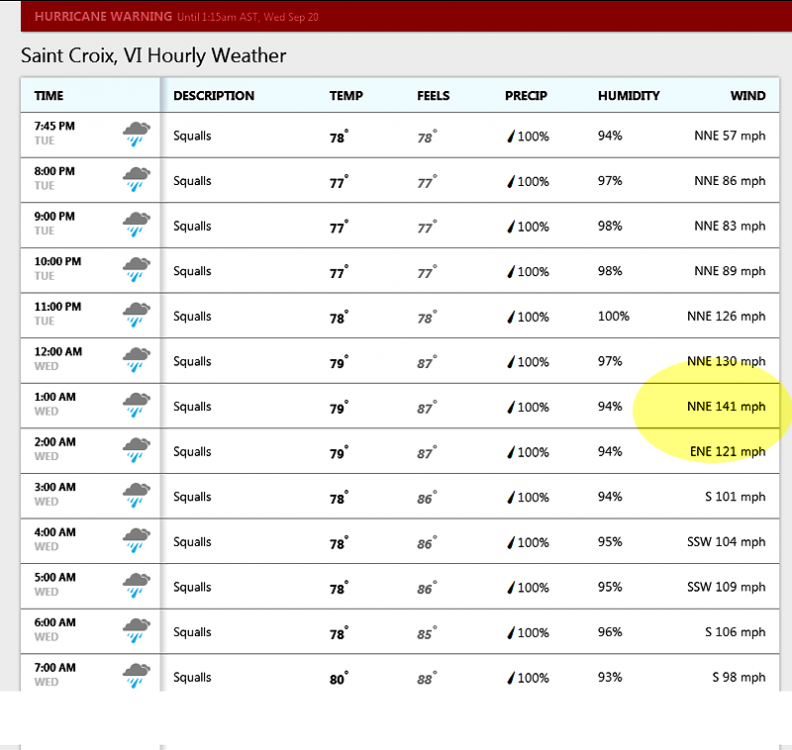
The anemometer on the north side of St. Croix got up to 64 knots, then appears to have broken or stopped transmitting. Barometer still working. Water rising On the south side of the island, the 'Lime Tree Bay' station has similar numbers, and worsening conditions https://tidesandcurrents.noaa.gov/stationhome.html?id=9751401
-
Maybe.
-
Some news coming out of Dominica slowly from 'ham radio' operators, sporadically, but the essence is bad, very bad http://wicnews.com/caribbean/dominica-devastation-emerges-fatalities-90-buildings-destroyed-44575828/ 90 percent of housing 'destroyed', known fatalities, landslides, flooding It seems the damage is comparable to that of Barbuda, with the exception that Dominica is far more mountainous and therefore landslides are likely


