

Kleimax
-
Posts
423 -
Joined
-
Last visited
Content Type
Profiles
Blogs
Forums
American Weather
Media Demo
Store
Gallery
Posts posted by Kleimax
-
-
Measured 3.5 inches in Owings Mills
-
 3
3
-
-
Getting smoked in Owings Mills
-
5
-
-
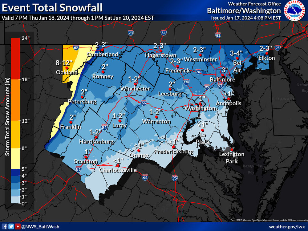
Seems like the expected snowfall map from LWX increased from this morning for northern areas
-
1
-
-
4 minutes ago, mappy said:
Anyone in Balt City or north seeing snow?
Very light pixie dust in Garrison
-
50 minutes ago, wtkidz said:
You all might want to look at this…. It appears to be coming…
Arkansas Pummeled
-
 2
2
-
-
All rain in Garrison

-
That cell that came through Pikesville was gnarly. Took the power out for a few seconds
-
1
-
-
Wasn’t really that bad in Pikesville
-
1
-
-
 We can't stop losing!
-
What's the NASA model showing?
-
-
The FV3 is a little juicier

-
Tony Pann is posting the 48hr HRRR. It’s happening
-
 4
4
-
-
Just like that, GFS has a storm threat Jan 22-24
-
1 hour ago, Ralph Wiggum said:
It is mind boggling to watch the snow line recede across the Eastern US as we approach peak climo

Can't believe Buffalo has no snow on the ground after the 200 inches they've received this year
-
 1
1
-
-
1 hour ago, psuhoffman said:
Ji is right. The high is actually in a perfect position.

Banana over the top! The other map only showed the center of highest pressure giving the false impression the high was not ideal. Actually this is a great pressure representation. Can we please stop trying to find excuses. The thermal profile over N America is just so warm that it makes it REALLY difficult and even with a perfect High and low track it might still only end up a mostly rain event. What it did this run was at least mean some frozen to start and a snow event for the mountains. But even with a close to perfect synoptic progression it wasn’t enough to save us because the airmass is just so awful.
Isn't the storm supposed to create it's own cold air or something?
-
1
-
1
-
-
2 minutes ago, Cobalt said:
The 0z 3k NAM has its best depiction of the snow associated with the front. Shifted a bit North, but definitely a swath of 1"+ that wasn't as prominent in previous runs.
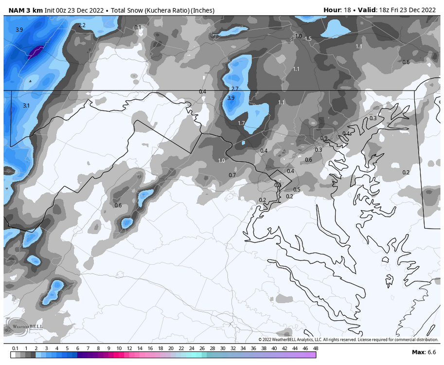
Towson jackpot
-
22 minutes ago, Ravens94 said:
Definitely a coastal low signature trying to form in NC

It's the Tony Pann coastal low
-
2
-
2
-
-
Noob question here please don’t roast me, but why do the higher elevations stay colder longer? I thought “cold air sinks” and “heat rises”, so shouldn’t the lower elevations stay colder than the mountains?
-
1 hour ago, midatlanticweather said:
The winter of ever delays! It feels like this may the case.
How about the 45 day Snow outlook.. I think maybe something is showing up on this in the southeast! We get that Nina split too! Painful. Reminds me or 2010 - 2011 season
![May be an image of map and text that says 'DAY10 10 DAY 15 20 25 30 35 45 ECMWF EPS 45- DAY Total Snowfall [inches 10:1 Liq Equiv Ratio) -> Ensemble c01 Init: 00Z05DEC2022- [1080] hr 00Z05DEC2022 Thu 00Z19JAN2023 MAX: 296. INCH orecast .1'](https://scontent-iad3-2.xx.fbcdn.net/v/t39.30808-6/318088370_5949245965142615_4665214801028510572_n.jpg?stp=dst-jpg_s960x960&_nc_cat=106&ccb=1-7&_nc_sid=5cd70e&_nc_ohc=O9zqbi9pynwAX_hZtC1&_nc_ht=scontent-iad3-2.xx&oh=00_AfCX3tQmENKgTqiOP-VLTGu4-upXT4v9GsbqcgXz3e8NpA&oe=63946F10)
Even Mexico gets more snow than we do

-
Severe Thunderstorm Warning for Allegany and Garrett County... Don't see that too often in Late November

-
1 minute ago, turtlehurricane said:
Can you please post link to where you get cmc runs this early. Or at least pic of new forecast
-
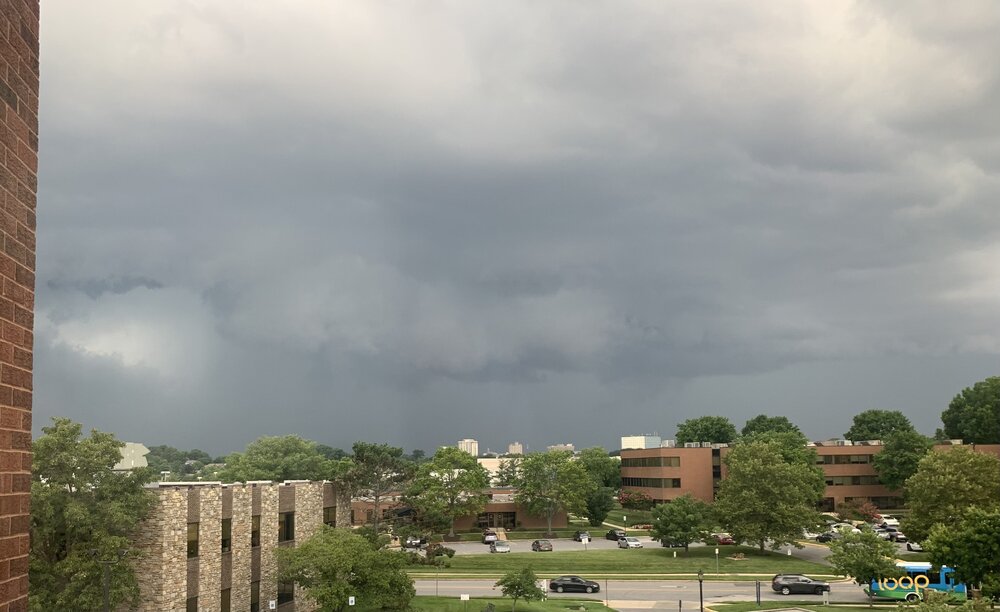 Got the shelf cloud coming in to east Towson/ Loch Raven area. Windy once it blew through, Lots of rain, not much lightning or thunder though
-
3
-
-
That outflow boundary was nice in Towson. The big storm went just north. Debris on the roads. Storm firing behind, warned in Caroll and Baltimore counties now
-
1
-


2024 Severe Weather General Discussion
in Mid Atlantic
Posted
Loud thunder in Owings Mills, sounds like a summertime thunderstorm