

BlunderStorm
-
Posts
1,121 -
Joined
-
Last visited
Content Type
Profiles
Blogs
Forums
American Weather
Media Demo
Store
Gallery
Everything posted by BlunderStorm
-
I think I will retire for the night a quarter inch of snow has accumulated thus far as my final observation of the night. The temperature remains a steady 32 with light snowfall. A burst of moderate/heavy snow at this point would likely turn the roads white for a short time. It was enjoyable to observe and I guess my goal for the night was achieved in spite of the temperature woes.
-
The temperature is at freezing snow is beginning to stick to the grass so I can record a trace so far.
- 225 replies
-
- 1
-

-
- mountain snow
- thunderstorms
- (and 5 more)
-
It is now 34 the transition to snow is mostly complete with light snow but big flakes. The next hurdle is to get it to stick.
-
Tonight has been a perfect example of the phenomenon just as it was last week. For those in the New River Valley when it comes to winter weather this occurrence is like CAD in the piedmont only elevated with even more favorable conditions. It also marks where I consider the NE edge of our forum it is where the primary spine of the Appalachians transitions from the Blue Ridge to the Allegheny as the dominant range. To re-iterate it has been a long stubborn fall in temperatures to the west of it. I am currently at 37 and have seen a few melting flakes finally begin to fall.
-

Spring/Summer 2018 Mid to Long Term Discussion.
BlunderStorm replied to John1122's topic in Tennessee Valley
Knoxville and Nashville both under the gun atm. It seems snow is falling to 3,000 ft now over me and it seems temperatures are falling again. Im at 39 as of 12:55 AM. I'll be switching over to observations from here for the night. -
Spring/Summer 2018 Mid to Long Term Discussion.
BlunderStorm replied to John1122's topic in Tennessee Valley
My main concern is in simply getting snow established on the ground before dawn, if it can stay overcast and remain snowy I think It'll stay white. With the way the cold air is wrapping in, my area may very well be one of the last areas in the valley to change over though the terrain here is more favorable. As of now the temperature here has stagnated at 42F stubbornly and snow roughly begins at 3,500 ft to 4,000 ft. Looking at the short range models for Wednesday snow wise the hourly HRRR and RAP have not been very enthusiastic about the back edge of the system and snow could subside a lot earlier than expected if they turn out to be correct. The RGEM, ICON, and 12km NAM on the other hand maintain light snow throughout the day with some heavier bursts. The 3km NAM takes the middle ground in this case. Looking at the radar I am pleased to see the radar fill back in to the west of here and as mentioned before I think John is in the best position out of all of us for tonight certainly in a better position than me and the folks in the Kingsport Snow Hole of Approval. Olhausen and Kentucky according to the radar have probably had a good night for bonus snow as well. -
Spring/Summer 2018 Mid to Long Term Discussion.
BlunderStorm replied to John1122's topic in Tennessee Valley
Meanwhile 70 miles west snow is only falling at 4,500ft on the peak of Beartown Mountain just to my south and the Grayson Highlands according to the radar. It really shows the discrepancy and sharp gradient in temperatures to the east. Currently it is 44F with no rumbles of thunder to report. Of course it is expected and spirits are up at least over here.- 279 replies
-
- 1
-

-
- tornado
- thunderstorm
- (and 5 more)
-
Spring/Summer 2018 Mid to Long Term Discussion.
BlunderStorm replied to John1122's topic in Tennessee Valley
As of now for 6:16 PM it is 49 degrees it's looking like it's going to be a long messy change over fittingly over me and far NETN like last week between two areas of significantly cooler air. Still the front has not passed so I'm unsure how much of a drop I'll see. Thus far I've pulled victory from the clutches of defeat multiple times this winter season so it is looking great. Being young I'm almost always for snow and this is no different so it is time to get on board of this winter threat for what is likely the last go around for me and the rest of you all. If you're north of I-40, on the plateau, or feeling lucky come on aboard! UPDATE: 7:05 PM Now it's 45.- 279 replies
-
- 1
-
-
- tornado
- thunderstorm
- (and 5 more)
-
Spring/Summer 2018 Mid to Long Term Discussion.
BlunderStorm replied to John1122's topic in Tennessee Valley
This probably falls more into the realm of observations but in my favor rain has been on and off all morning and past noon in a nearly stationary area of showers. It has been keeping the temperatures in the low 50s as opposed to the upper 50s I'm forecast for. Here are the obs from the near by airport though it is 550ft higher. https://www.wrh.noaa.gov/zoa/getobext.php?sid=KJFZ -
Spring/Summer 2018 Mid to Long Term Discussion.
BlunderStorm replied to John1122's topic in Tennessee Valley
Yep you weren't kidding Carver this run of the NAM is certified by the Kingsport Snow Hole of Approval...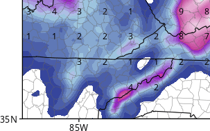
- 279 replies
-
- 3
-

-
-
- tornado
- thunderstorm
- (and 5 more)
-
Spring/Summer 2018 Mid to Long Term Discussion.
BlunderStorm replied to John1122's topic in Tennessee Valley
The trick in getting this heavy snowfall would be in getting the temperatures down faster which I'm not too confident will occur. I have never understood the significant difference in temperature between the New River Valley and Holston/Clinch River Valleys. This difference in temperature is usually between Marion and Wytheville as well as between Tazewell and Bluefield. It can prove to be quite significant and I have noticed over the years as my weather awareness has increased. Keep in mind there is no mountain range separating the towns just the flow of streams in the two valleys with Clinch mountain running parallel. The 3km NAM, RGEM, and HRRR all show this very well for tonight with a sharp temperature gradient. Similar to what happened last week I speculate a late change over in the early morning will happen that hangs on through the day snowing but perhaps not accumulating. Perhaps finally amounting to an inch or more after dark. Areas east of me will likely see their totals increase drastically over a short distance. I am not sure how scattered the snow will be on the back side, high resolution models from a glance do in fact seem more scattered and less as a shield of precipitation but it may be wrong.- 279 replies
-
- 1
-
-
- tornado
- thunderstorm
- (and 5 more)
-
I had just been in Johnson City as the storms hit around dusk when about 30 minutes into one of the storms it began to hail. Luckily (pun intended) the hail was small and no damage was done to any cars or property at least from what I saw. I would say the hail was roughly a centimeter or a little more in diameter and it lasted around 5 minutes. Once the rain died down a little I came outside it looked like it had snowed in the grass. I thought the novelty of seeing significant snow and hail within a few days was pretty amusing truly March at its finest. Unfortunately I did not have a camera on me at the time so I didn't capture anything. It's also worth mentioning I saw some pretty spectacular streaks of lightning too.
-
Southeast Sanitarium - A Place to Vent
BlunderStorm replied to Jonathan's topic in Southeastern States
Still plenty of action left for Wilmington. At least you guys have a storm to follow it is pretty frustrating here in the Tennessee Valley with plenty of activity in the ohio valley and southeast. So far annual snowfall has thrown climate out of the window. Heaven forbid more than an inch of snow falls here. Still it does put a smile on my face when places like Tallahassee, Valdosta, and Savannah see snow. Even if it means sub-zero temps for me. -
How did you find the passion for weather?
BlunderStorm commented on USCAPEWEATHERAF's blog entry in Once a legend always a legend
My love and interest in weather has always existed in me. Being a teenager my interest was only truly brought to the forefront less than three years ago during the February 2015 North American Cold Wave. To be exact it was the President's Day Snowstorm of 2015. I remember Sunday, February 15, vividly with anticipation as winter storm "Octavia" termed by the weather channel was on the march east. The snow on radar at one point spanned from Denver, Colorado to Roanoke, Virginia. That night and the next morning I binge watched the weather channel. During that night in fact as I was browsing I happened upon a forum called American Weather. The storm arrived Monday and the school had closed in advance of the storm due to President's Day. Around 10:30 A.M. the flakes started falling and they did not stop until late in the night. On Tuesday I awoke to a winter wonderland with just over a foot of snow on the ground. School remained closed for the rest of the month and multiple winter storms accompanied by arctic cold would follow in it's wake leaving a snow pack on the ground well into March. From there each year onward my interest in weather increased. Surprisingly I would remain a lurker on this site until this year.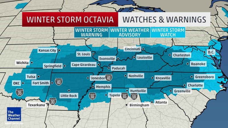
-
Would this work? http://compressimage.toolur.com/
-
You and I both Tellico! I have wanted to punt this system for the past 3 days but I'm always on the edge of being in this...Cmon, NW trend!
-
August 21, 2017 (was "2 Years From Today!")
BlunderStorm replied to rbowman's topic in Tennessee Valley
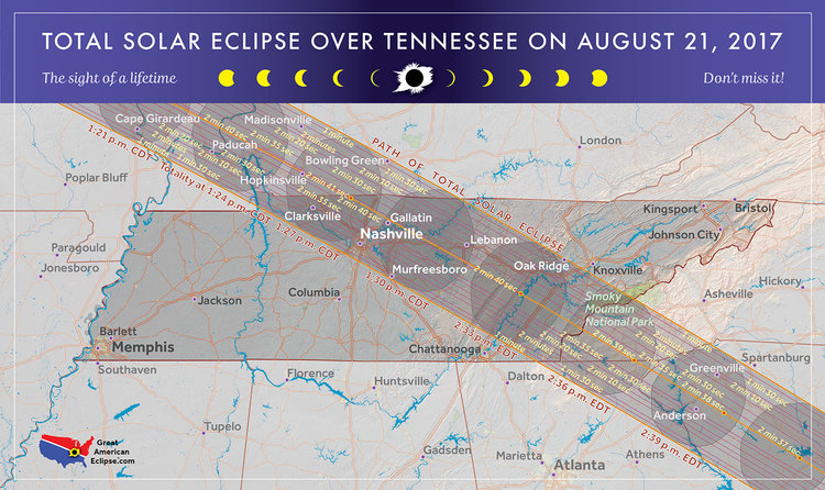
It was an event witnessed that we shall never forget. It has been nice viewing all the wonderful images from not just our sub-forum, but from all over the American Weather community. I consider myself very lucky to have witnessed this glorious celestial event in complete totality. With the end of this eclipse we now look forward to 2024...see you there. -
August 21, 2017 (was "2 Years From Today!")
BlunderStorm replied to rbowman's topic in Tennessee Valley
Conditions were great for the eclipse I'm glad all turned out well for everyone, anyway here is was my one photo of totality! : )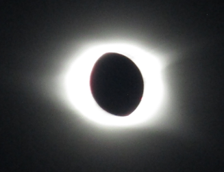
-
August 21, 2017 (was "2 Years From Today!")
BlunderStorm replied to rbowman's topic in Tennessee Valley
My dad and I made it to Etowah in good time. (4-1/2, hours) it seems at least to some extent the traffic jams and general chaos were exaggerated to our surprise. Tomorrow may tell another story of course. This evening despite traffic along overlooks we enjoyed the Cherohala Skyway going both ways. Originally we were going to attempt to settle on Huckleberry Knob but to our surprise not only was the parking lot taken, so was the mile leading to it and away from it. Originally we had booked on NC closing the shoulders of the skyway as TN did, however this was not the case, so any plans to sneak up the mountain in the wee hours of the morning were shot down. Of course, we had some what expected the possibility of this occurring so we will happily settle in Tellico Plains for the event. I must say I am pleasantly surprised by our prospects of seeing the eclipse in Tennessee, it would seem as though it is one of the best places if not debatably the best. (Dare I say) to view the eclipse east of the Rockies. Anyway, that's enough rambling for tonight. I wish a happy eventful day with clear eclipse viewing skies to everyone. Here we go! -
August 21, 2017 (was "2 Years From Today!")
BlunderStorm replied to rbowman's topic in Tennessee Valley
I see that you are new, welcome aboard! In case you do not already know the forum explodes with activity every Winter ramping up as the leaves change and fall. Normally we would be in the summer time doldrums of days between posts but of course with the eclipse it seems the active season on this forum has got to an early start. -
August 21, 2017 (was "2 Years From Today!")
BlunderStorm replied to rbowman's topic in Tennessee Valley
Well, my original plan was to go up the Cherohala Skyway but in light of (possible) blocking or no parking I may go to Athens, view it on a lake or on the Cumberland Plateau. No matter where you decide to go keep your plans dynamic and able to change at a seconds glance of a cloud. -
August 21, 2017 (was "2 Years From Today!")
BlunderStorm replied to rbowman's topic in Tennessee Valley
Nine and a half days til the eclipse. I imagine now forecasts are becoming relevant. -
August 21, 2017 (was "2 Years From Today!")
BlunderStorm replied to rbowman's topic in Tennessee Valley
Two people on the same sub-forum with the exact same idea, this doesn't look good. Luckily enough my dad booked a room back in April just before rooms had become unattainable so we won't be driving in. My dad and I are going to try to get up there before sunrise, that is assuming weather conditions are favorable. From what I read as long as all four wheels are off the skyway it is legal parking wise. "Where to Park: There is no official parking at this spot, but the Skyway rules are the same as any other national park property: get all four tires off the Skyway and you’re fine" Here is a guide for anyone interested. http://www.southeasterntraveler.com/travel-guide-solar-eclipse/tennessee/cherohala-skyway/ -
August 21, 2017 (was "2 Years From Today!")
BlunderStorm replied to rbowman's topic in Tennessee Valley
-
Southeast Sanitarium - A Place to Vent
BlunderStorm replied to Jonathan's topic in Southeastern States
I'm holding you up to that. Always that 1% chance.