STILL N OF PIKE
-
Posts
14,841 -
Joined
-
Last visited
Content Type
Profiles
Blogs
Forums
American Weather
Media Demo
Store
Gallery
Everything posted by STILL N OF PIKE
-
Did you fall ski’ing ?
-
Anyone have a radar w rain/ snow line . I’m at work . Please and thanks
-
Let’s get the kitchen sink to fall out the sky by the pike with the heavier precip
-
Wow Monday kinda went to crap for northern NNE Weaker looks better more CNE and Berks monads just saw the models
-
A good ole flare up
-
I don’t know if you start as rain for more than a hour or two , it could but ..seems now casty
-
Rt. Poop , nice . We pray that area is snow
-
Where in the Berks are you
-
I’ve just been sorta monitoring the odds on the WPC Site in addition to following models . Right now Nashua is 60% for 2”> by 12z Friday as of the 430 am update . And then looks to finish with 3-4” or so total by end of day Not sure if they even put that much into creating these but more watching their trends Concord NH to say Wildcat to west central maine has best odds (70-85%) for 6” for the duration of this event
-
The point and click forecasts touch on mixing just over the NH border WPC snow probs for 2” plus definitely highest for MHT north into NNE on first batch Thru Friday 12z
-
Are you channeling money pit mike Just kidding it could be close even at 427’ in Nashua
-
Box mentioned relatively low confidence in northern zones ..watching short term trends etc . Seems euro / gfs look good . Reggie / Ukie tickled N
-
Enjoy man !
-
Ya give some folks a sloppy inch of apple sauce for their efforts this year
-
at some point the parade of storms slows down for us , so we can’t keep swinging and missing and thinking Mother Nature is gonna keep lobbing in meatballs for us to crush later from some gradient fairy
-
We sell let’s not follow the formula of how to be Set up to be disappointed in a 6” snower , when we haven’t had a real snow storm so far . I know you were just mentioning that model , that’s all
-
Lollis to 12” on the great mountain w a base of 650’
-
Bump
- 203 replies
-
- 1
-

-
- ratter
- regression
- (and 1 more)
-
Will sort of tried to get ahead of the Melts that will occur by being very cautious on the next two upcoming threats and even the third . But he knows it’s no use if we gonna rain in SNE for most of this stretch . The First system has the most favorable potential for winter weather in northern 1/2 of SNE and then it’s a matter of how progressive the second system is on Monday since there is no semblance of a high pressure like at least the Thursday nite / Friday deal has . So ski country really needs to hope it can tick a bit more progressive and VT looks to have best shot to me . The third system at day 8-8.5 is still far enough out that there is winter hope Im really hoping the Monday storm can be solid for the resorts
-
Ya the risk is basically Favored for SNE
-
Gotcha Makes sense the Second part is more up in the air for where it focuses. We need the south side of a ULL to bless us
-
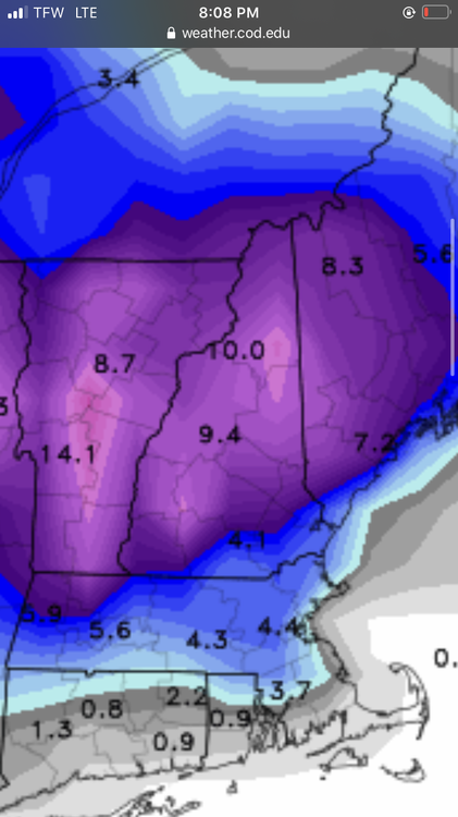
Thanks much neater than my post the first batch Thur nite got Boston and even areas S and SW with almost a SWFE look to accums
-
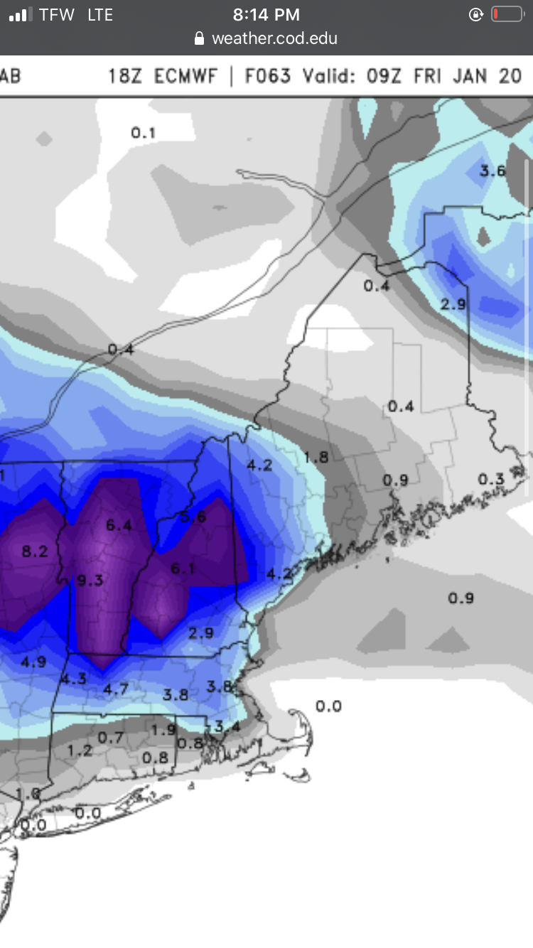
Actually most of the snow around the pike on The 18z euro image is Thur overnite this run It looks like it adds a 1/4-1/2” near pike overnite Friday and keeps the ull stuff further north on that run this thru 5am Friday

-
Somehow 18z euro gives Attleboro more snow than tolland with the overnite stuff late Thursday . Odd. But either way snow is further south on 18z euro for what that’s worth . Then the ULL stuff stays in CNE /NNE this map is thru Friday 21z
-
Hanging by a thread , tolland needs Friday