

Will (little rock)
-
Posts
64 -
Joined
-
Last visited
Content Type
Profiles
Blogs
Forums
American Weather
Media Demo
Store
Gallery
Posts posted by Will (little rock)
-
-
What a terrible trend
-
28 minutes ago, StormChazer said:
Yeah, those are some high ratios.
Not sure what the math is, but I’d say 15-20:1?
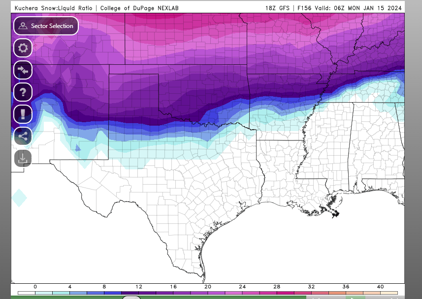 Yeah, looks about right. 16-20 or so
-
 1
1
-
-
Gonna head to the Missouri boot heel tomorrow for the snow, can’t help myself lol
-
1
-
 1
1
-
-
Well, that wasn’t what I expected
-
Through hour 72 of GFS, energy is further south
-
Man I’d love to see that low pressure track drop south a little more…
-
1
-
-
GFS digging a bit more…. Looks a bit better synoptic-wise
-
Hard not to get excited after seeing that run
-
1
-
-
Worth noting that the nam is initializing quite a bit drier than what the current radar shows.
-
3
-
-
12z ICON with a decent shift southwest
-
1
-
-
1 minute ago, janetjanet998 said:
18Z HRRR continues to develop many discrete storms ahead of a line. and races that across AR area..from 03z to 09z
almost too many
I've noticed that on the last several runs. Quite a few of them
-
1
-
-
If only 228 hours out was accurate. Crazy
-
Just now, John1122 said:
The 39 hour rap is running. Looks like it will snow from Texas to Tennessee on it as well.
Where do I find this map?
-
Just now, TellicoWx said:
Big run coming for CMC...C AR / W TN (Memphis) big jump vs 12z
Sent from my SM-S767VL using Tapatalk
Oh yeah, im enjoying this trend
-
2 minutes ago, Carvers Gap said:
What do you all think about firing up a thread for the Tuesday event? I don't mind discussing it here either. Just thinking that it might be thread worthy at this point.
I second that. Been following this thread for weeks but finally logged in. Models definitely have been agreeing on somewhat of an event.
-
1
-
-
Past this storm, looking waaaaaay out to next weekend, there seems to be some similarities with a system between the FV3, GFS, and CMC. Still far out but still worth watching
-
1
-
-
Looking out past this storm, the GFS, CMC, and FV3 GFS are showing something possible next weekend
-
Yeah, would definitely be nice to see a few flakes later today!
-
1
-
-
1 hour ago, Holston_River_Rambler said:
Euro looks ok for 6 days out for the Jan. 3-5th storm (in that it is still there), but for this run anyway, just not enough cold air outside of elevation for most of TN. For any Arkansas folks who may be around though: https://imgur.com/a/2Xgulse
lock it in! LOL
-
3
-
1
-
-
Interesting storm possible on Wednesday and Thursday for parts of Central and Southern Arkansas, especially on the last few runs
-
6 minutes ago, John1122 said:
10:1 FV3 is 10-12 inches from Central Arkansas to the Plateau in a SW to NE orientation. From the Eastern Plateau to Tri its 12 to 16 inches. South of 40, east of Davidson it's 2-5 inches with 6 inch pockets all the way through with totals beginning to climb towards 9 inches near the Smokies and over a foot in the mountains. Take 30-40 percent off these for ratio purposes.
Wow if that happened, that would really be amazing
-
-
Just now, tramadoc said:
Ban hammer incoming in 3... 2... 1...
Sent from my iPad using TapatalkThat was quick, nicely done mods lol
-
2
-
-
4 minutes ago, StormChazer said:
I've been analyzing the Euro runs for a couple days now, here is my findings from last night in regards to how the Tulsa metro is affected.
10 members show 0-2 inches of snow
6 near misses or right on the steep snow gradient
34 members show heavy snow(I'm defining "heavy" as 4+ inches)
20% little to nothing
12% near misses or right on the steep snow gradient
68% Winter storm warning criteria
So there has definitely been a trend, each run of the Euro is putting more and more members with a large swath of Oklahoma getting a good amount of snow.
How are the ensembles generally looking for central Arkansas? Noticed the NAM shift south but then again it's the NAM 84 hours out lol
MO/KS/AR/OK 2023-2024 Winter Discussion
in Central/Western States
Posted