
CNY-WXFREAK
-
Posts
3,872 -
Joined
-
Last visited
Content Type
Profiles
Blogs
Forums
American Weather
Media Demo
Store
Gallery
Everything posted by CNY-WXFREAK
-
Upstate/Eastern New York
CNY-WXFREAK replied to BuffaloWeather's topic in Upstate New York/Pennsylvania
80/20 I would say so it must be coming in from the NW cause, cause Fulton went first then Phoenix, now it my turn then yours I'd imagine. -
Upstate/Eastern New York
CNY-WXFREAK replied to BuffaloWeather's topic in Upstate New York/Pennsylvania
It's coming down now. Its gotta be snowing near you Bri, no? If not hen it can't be far behind. -
Upstate/Eastern New York
CNY-WXFREAK replied to BuffaloWeather's topic in Upstate New York/Pennsylvania
I understand and seems very plausible I suppose. If anything, it'll be fzdz as temps should fall below freezing tomorrow night. -
Upstate/Eastern New York
CNY-WXFREAK replied to BuffaloWeather's topic in Upstate New York/Pennsylvania
Oh, and WNY is getting the shallaking they deserve. I could care less about KROC , nah, you guys dewserve a good one to but I can't understand why we don't deserve one, lol? -
Upstate/Eastern New York
CNY-WXFREAK replied to BuffaloWeather's topic in Upstate New York/Pennsylvania
I know yo did especially with a commute to KALB, ugly to say the least, thats if you go. -
Upstate/Eastern New York
CNY-WXFREAK replied to BuffaloWeather's topic in Upstate New York/Pennsylvania
I'm over to mostly parachutes now, so now the fun begins, and lets see where we end up by tomorrow 18Z. Even though its snowing I don't think it'll start to accumulate till at least 3AM perhaps later so thats not good news. -
Upstate/Eastern New York
CNY-WXFREAK replied to BuffaloWeather's topic in Upstate New York/Pennsylvania
i also just posted about the transfer and robbing it of its energy so I completely understand, trust! -
Upstate/Eastern New York
CNY-WXFREAK replied to BuffaloWeather's topic in Upstate New York/Pennsylvania
I just did, the 18Z but I didn't go any further. So your saying it ends as a light rn drizzle type ****e? -
Upstate/Eastern New York
CNY-WXFREAK replied to BuffaloWeather's topic in Upstate New York/Pennsylvania
18Z tomorrow, temp of 29 with S+ Actually light snow with small non accumulating flakes, so you could be right especially with the <arch SUN ANGLE. lol! -
Upstate/Eastern New York
CNY-WXFREAK replied to BuffaloWeather's topic in Upstate New York/Pennsylvania
Nothing I looked at, saw or read said any of this but you may very well be right. I saw a high tomorrow of 31 for KFZY so I guess we'll see! Warning goes till 1AMN from KBGM which is quite surprising. anyway I'm still oprtimistic for at least 8" here so we'll see bruh! -
Upstate/Eastern New York
CNY-WXFREAK replied to BuffaloWeather's topic in Upstate New York/Pennsylvania
Every so often a parachute will mix in, lol! -
Upstate/Eastern New York
CNY-WXFREAK replied to BuffaloWeather's topic in Upstate New York/Pennsylvania
Same here and its all snow in KFXY, go figure. Do they have any sort of elevation in and around Fulton? I think up near the airport is a bit higher. I'm at 495' which means nothing but they can be a bit higher. Wouldn't take much at all. -
Upstate/Eastern New York
CNY-WXFREAK replied to BuffaloWeather's topic in Upstate New York/Pennsylvania
Now this is a classic Negative Tilt to the atmosphere producing intense lift! H300 H500 -
Upstate/Eastern New York
CNY-WXFREAK replied to BuffaloWeather's topic in Upstate New York/Pennsylvania
I'm just hoping there isn't a Coastal that quickly rips away the energy over the area as that is a distinct possibility, but rather I'd love to see this morph onto a stacked ULL right over NYC and let it sit and spin for 6-10 hrs as that would be the most ideal situation but not likely. Its beginning its transfer, but should do so slowly, or at least thats what the guidance shows. I stiill think there will be some definite surprises with this monster IMO. -
Upstate/Eastern New York
CNY-WXFREAK replied to BuffaloWeather's topic in Upstate New York/Pennsylvania
Especially on the enhanced WV imagery, just WOW! -
Upstate/Eastern New York
CNY-WXFREAK replied to BuffaloWeather's topic in Upstate New York/Pennsylvania
This beast is seriously amped with thunderstorm like convection billowing around the center of the SLP, which is is NWPA and hauling azz East, but it should slow as it realizes it really has nowhere to go just yet, lol! -
Upstate/Eastern New York
CNY-WXFREAK replied to BuffaloWeather's topic in Upstate New York/Pennsylvania
The flip has begun, yay. -
Upstate/Eastern New York
CNY-WXFREAK replied to BuffaloWeather's topic in Upstate New York/Pennsylvania
Your a funny guy! Your gonna wake up to 6"+, of concrete, lol! + -
Upstate/Eastern New York
CNY-WXFREAK replied to BuffaloWeather's topic in Upstate New York/Pennsylvania
Really? Awesome, lol! We're all good then. -
Upstate/Eastern New York
CNY-WXFREAK replied to BuffaloWeather's topic in Upstate New York/Pennsylvania
Not concerned at all as those 60 degree days felt real good! -
Upstate/Eastern New York
CNY-WXFREAK replied to BuffaloWeather's topic in Upstate New York/Pennsylvania
So your expecting mostly rain then I suppose? Not buying Teske's 8-12" for YBY? -
Upstate/Eastern New York
CNY-WXFREAK replied to BuffaloWeather's topic in Upstate New York/Pennsylvania
So it started as snow everywhere else in NYS except here in Oswego County? Do both of you guys, Max and CNY, have rain falling or a mix? -
Upstate/Eastern New York
CNY-WXFREAK replied to BuffaloWeather's topic in Upstate New York/Pennsylvania
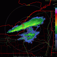
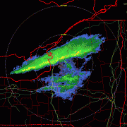
And the rain has begun and heavy right off the bat with a temp of 38F. Look at how the warm air gets tucked in just to the SE of the Lake right over my house, lol -
Upstate/Eastern New York
CNY-WXFREAK replied to BuffaloWeather's topic in Upstate New York/Pennsylvania
We're jealous over here, lol, as we patiently wait for our rain to begin. -
Upstate/Eastern New York
CNY-WXFREAK replied to BuffaloWeather's topic in Upstate New York/Pennsylvania
I'll give it another hour an it'll be pounding rain here with a quick changeover, I hope, but the new discussion out of KBGM says it will rain till mid morning before changing over SE of the lake along the lake plain but I just can't see that happening but anything can happen here and its not usually good. Good for all you guys who are experiencing a hybrid Nor'Easter, lol, as I have experienced about 20 while living in Jersey City.

