

Brick Tamland
-
Posts
12,210 -
Joined
-
Last visited
Content Type
Profiles
Blogs
Forums
American Weather
Media Demo
Store
Gallery
Posts posted by Brick Tamland
-
-
All the local TV mets here called for above average snow here. Huge bust. Looks like it's not even going to snow. Couldn't even get a system that was close to snow. Everyone bet on the Nino to bring us more snow. Something has definitely changed because the things that used to be good for us in the past to get snow here don't seem to work as well.
-
Hard for me to believe it's going to snow here this winter until it actually does. I don't care how good the pattern supposedly is, the past few winters have been terrible for snow.
-
 2
2
-
-
I'm sure we'll get cold again in February after the warm up this week. I just don't think we'll have any precip to go along with it when it's cold enough for snow. It's been the same thing the last few winters. Cold and dry, warms up and rains, drys out in time for it to get cold again. Until that doesn't happen I don't see any reason to believe it's going to be any different in regards to snow chances in NC outside the mountains, and especially for the Triangle and east.
-
1
-
 1
1
-
 2
2
-
-
1 minute ago, GaWx said:
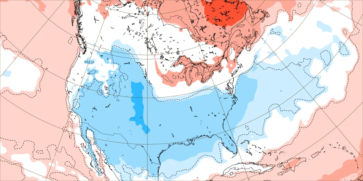
New Euro Weeklies for Feb 12-19: Does this look at all like winter is over in the SE? Not to me unless we’re playing the game of opposites:
H5 hts lowest of any run in SE and also suggests split flow with both a +PNA and BN hts from S CA/Baja eastward typically associated with moist subtropical jet
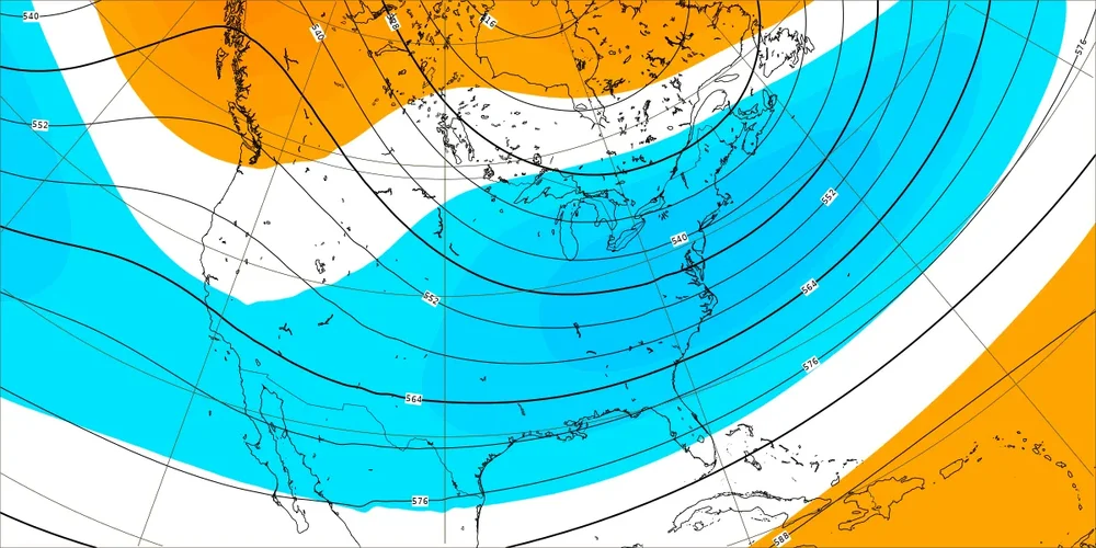
Easily both the strongest and also most widespread BN temperature signal yet by and it has been getting progressively colder:
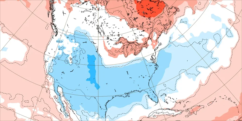
Check out the wet subtropical flow from S CA/Baja into SW US/MX and then over N GOM/Gulf coast/S GA/S SC to NC coast and offshore SE US with all of the SE near to wetter than normal
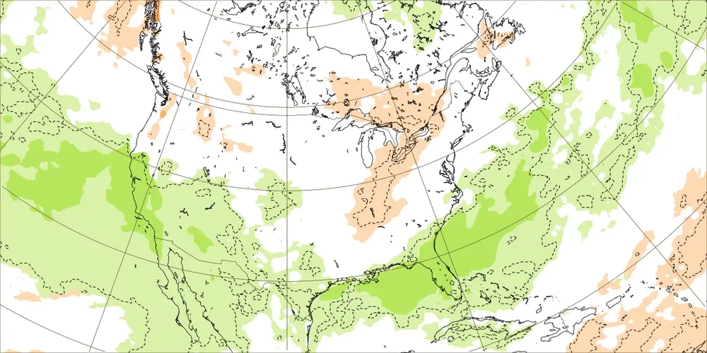
This combo of maps is suggesting an El Niño induced GOM Miller A mixing with widespread cold that would be a near perfect setup for a widespread major SE winter storm near the most favorable climo for it (moderate or stronger Nino in mid Feb).
I'll believe it when it happens. Just think we'll get more of the same. Dry when it's cold and rain when it warms up.
-
1
-
 1
1
-
-
29 minutes ago, WinstonSalemArlington said:
Eric Webb: “
Over the next several weeks, we're repeating the same pattern progression we had in late Dec thru mid-Jan, except the cold(er) pattern on the backend of next week's Pacific Jet extension likely lasts longer (per usual for El Nino)
Aside from Nino climo, +IOD collapse favors a slower/stronger bout of Indian Ocean forcing late in Feb into Mar, helping to keep the gravy train going.
Remember that unlike Dec-Jan, Indian Ocean convection in Feb-Mar actually signals cold in the eastern US.”
Pretty desperate if we're already talking about March. I don't believe there's a chance of any winter weather here past February.
-
2
-
1
-
-
Another horrible winter for NC east of the mountains. When it's cold enough for snow it's dry. And when it warms up it rains. It's the norm here the past few years.
-
2
-
2
-
-
Any threat of severe storms or tornados inland?
-
Officially have Tropical Storm Ophelia.
BULLETIN
Tropical Storm Ophelia Intermediate Advisory Number 5A
NWS National Hurricane Center Miami FL       AL162023
200 PM EDT Fri Sep 22 2023

...CYCLONE BECOMES TROPICAL STORM OPHELIA...
...TROPICAL STORM CONDITIONS CONTINUING ACROSS COASTAL PORTIONS OF
NORTH CAROLINA...


SUMMARY OF 200 PM EDT...1800 UTC...INFORMATION
----------------------------------------------
LOCATION...32.7N 76.0W
ABOUT 150 MI...240 KM SE OF CAPE FEAR NORTH CAROLINA
ABOUT 185 MI...295 KM S OF CAPE HATTERAS NORTH CAROLINA
MAXIMUM SUSTAINED WINDS...60 MPH...95 KM/H
PRESENT MOVEMENT...NNW OR 345 DEGREES AT 12 MPH...19 KM/H
MINIMUM CENTRAL PRESSURE...992 MB...29.29 INCHES
-
1
-
-
Wonder if folks up here in the Triangle need to prepare for downed trees and power outages. Not sure if it will be that bad up here or not.
-
2
-
-
Level 3 threat. Doesn't sound good. Hope we have some junk earlier in the day to stabilize things.
-
1
-
-
Finally feeling like summer next week. And a level 2 severe threat for Monday.
-
1 hour ago, PackGrad05 said:
EPS still looks interesting for the 1/25-1/26 time period.
And tonight's "flurry" event is a perfect example of how quickly things can change. I know it isn't really a big deal, but it only popped up in the past 1-2 days.
Hard to really trust anything past a couple of days anyway. The models love to show something in the 7 to 10 day range only for them to disappear the next day.
-
1
-
-
Know exactly where that is. My office used to be off Slater Rd. Could have been worse. There are a bunch of offices, hotels, restaurants, and even a Walmart nearby.
-
Looks like there was damage to the Pfizer building in RTP and trees down there.
-
I'm in Wake Forest now and the sun was trying to come out for a little while. Hope all the excitement is over for here today.
-
Looks like it went up Creedmoor Rd to Wilton in Granville County.
-
Funnel cloud was spotted at RDU airport
-
WRAL said it looked like it was getting strong again and going into southern Granville Co west of Wake Forest.
-
11 minutes ago, NorthHillsWx said:
Definitely otg now. Classic debris ball showing on CC
Looked like it was right in RTP.
-
Mom and kids are in the bathroom. My wife is stuck at a school near Wake Forest.
-
Where is it headed? My mom and kids are at the house in Wake Forest.
-
Just got the alert for the tornado warning near RDU
-
Severe Thunderstorm Warning
NCC037-063-085-105-135-183-311945-
/O.NEW.KRAH.SV.W.0014.220331T1916Z-220331T1945Z/

BULLETIN - IMMEDIATE BROADCAST REQUESTED
Severe Thunderstorm Warning
National Weather Service Raleigh NC
316 PM EDT Thu Mar 31 2022

The National Weather Service in Raleigh has issued a

* Severe Thunderstorm Warning for...
  Southeastern Orange County in central North Carolina...
  Northwestern Harnett County in central North Carolina...
  Lee County in central North Carolina...
  Wake County in central North Carolina...
  Eastern Chatham County in central North Carolina...
  Durham County in central North Carolina...

* Until 345 PM EDT.

* At 315 PM EDT, severe thunderstorms were located along a line
  extending from near Carrboro to 7 miles south of Pittsboro to near
  Sanford, moving northeast at 50 mph.

  HAZARD...60 mph wind gusts.

  SOURCE...Radar indicated.

  IMPACT...Expect damage to roofs, siding, and trees.

* Locations impacted include...
  Raleigh, Durham, Cary, Chapel Hill, Sanford, Pittsboro, Garner,
  Carrboro, Fuquay-Varina and Angier.
-
2 minutes ago, NorthHillsWx said:
Active day with warnings so far but I have not seen anything indicating a touchdown yet
Yeah, lots of radar indicated rotation warnings. Hopefully, that's all we'll see. That seems to be the case most of the time when we don't get any sun ahead of time.

2024 Short/Medium Range Severe Weather Discussion
in Lakes/Ohio Valley
Posted
Listening to scanner feeds it sounds like Delaware, Ohio and now Indiana have been hit tonight. A trailer park in Logan County, OH was hit and was called a mass casualty incident.