

Chicago Storm
-
Posts
18,163 -
Joined
-
Last visited
Content Type
Profiles
Blogs
Forums
American Weather
Media Demo
Store
Gallery
Everything posted by Chicago Storm
-

Short-Term Severe/Flooding Discussion
Chicago Storm replied to Quincy's topic in Central/Western States
Nice couplet with the tor warned embedded supercell well SW of Faith, SD. Nice tor warned storm NE of Alliance, NE as well. -
Short-Term Severe/Flooding Discussion
Chicago Storm replied to Quincy's topic in Central/Western States
TOG recently with that storm NE of the AMA area... -
Short-Term Severe/Flooding Discussion
Chicago Storm replied to Quincy's topic in Central/Western States
Tor warned storm north of the AMA area... -
Short-Term Severe/Flooding Discussion
Chicago Storm replied to Quincy's topic in Central/Western States
Tor east of Trinidad, CO not too long ago. -
Central/Western Medium-Long Range Discussion
Chicago Storm replied to andyhb's topic in Central/Western States
It's not good for anyone who missed the good days during that active week in late-May, as that's the only time this season really produced. Looks like the traditional chase season will end as it started. We'll see if there's any surprise events between now and the fall season. -
Short-Term Severe/Flooding Discussion
Chicago Storm replied to Quincy's topic in Central/Western States
Nice sup in N. Mexico... -
Central/Western Medium-Long Range Discussion
Chicago Storm replied to andyhb's topic in Central/Western States
Change that to Tuesday and Thursday-Sunday and I agree. -
Central/Western Medium-Long Range Discussion
Chicago Storm replied to andyhb's topic in Central/Western States
The first trough (Sat-Mon) is meh in terms of potential, but it does help with moisture return for the 2nd trough (Tue/Wed). As mentioned above by others, Tues looks sig on both the GFS/ECMWF. Still 6 days out, so we'll see how it progresses. -
Central/Western Medium-Long Range Discussion
Chicago Storm replied to andyhb's topic in Central/Western States
Current period (4-6th) isn't too interesting, and I suspect the 7-10th will prove to be the same. Saturday obviously has the highest potential of any day between now and Sunday, but I'm leaning heavily towards it being underwhelming due to early/morning initiation. -
Central/Western Medium-Long Range Discussion
Chicago Storm replied to andyhb's topic in Central/Western States
Don't expect another worthy chase day for me until mid-month. Upcoming pattern until that point really doesn't look like anything more than run of the mill sort of events, though as Brett stated, something interesting could pop up on short notice. -
Anniversary of the 3/2/12 Tornado Outbreak
Chicago Storm replied to andyhb's topic in Lakes/Ohio Valley
If not for an accident on I-65 I would have been on the Henryville tor...Oh, what could have been... -
Devastating tornado strikes Joplin, Missouri
Chicago Storm replied to Hoosier's topic in Weather Forecasting and Discussion
It's good to hear you're alright, JoMo. -
Devastating tornado strikes Joplin, Missouri
Chicago Storm replied to Hoosier's topic in Weather Forecasting and Discussion
PUBLIC INFORMATION STATEMENT NATIONAL WEATHER SERVICE SPRINGFIELD MO 400 PM CDT MON MAY 23 2011 ...EF-4 TORNADO CONFIRMED IN JOPLIN... * DATE...22 MAY 2011 * MAXIMUM EF-SCALE RATING...EF-4 * ESTIMATED MAXIMUM WIND SPEED...198 MPH * ESTIMATED PATH WIDTH...3/4 MILE * FATALITIES...116 * INJURIES...400 * THIS PRELIMINARY INFORMATION WAS DETERMINED BY A NATIONAL WEATHER SERVICE SURVEY TEAM AND IS SUBJECT TO CHANGE PENDING FINAL REVIEW OF THE EVENT AND PUBLICATION IN NATIONAL WEATHER SERVICE STORM DATA. -
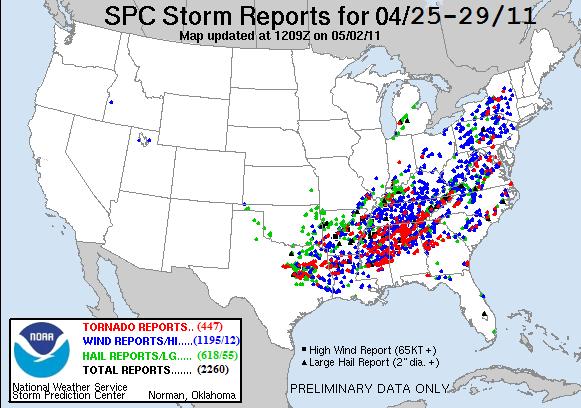
Historic Tornado Outbreak April 27, 2011
Chicago Storm replied to CUmet's topic in Weather Forecasting and Discussion
As posted in the main forum topic... Here's what I have... April 27th - 12AM-11:59PM (Local Time) Tornado Count: 179 Tornado Count Per CWA: MRX: 51 HUN: 31 JAN: 30 BMX: 29 MEG: 12 FFC: 10 OHX: 9 SHV: 4 LWX: 4 AKQ: 3 GSP: 2 LMK: 2 MOB: 1 RNK: 1 RLX: 1 ILN: 1 CTP: 1 BMG: 1 -
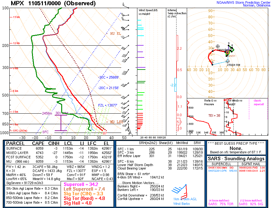
What's the most unstable sounding you've ever seen?
Chicago Storm replied to Hoosier's topic in Lakes/Ohio Valley
-
What's the most unstable sounding you've ever seen?
Chicago Storm replied to Hoosier's topic in Lakes/Ohio Valley
Happy birthday. -
What's the most unstable sounding you've ever seen?
Chicago Storm replied to Hoosier's topic in Lakes/Ohio Valley
You beat me to it, damn it... -
Historic Tornado Outbreak April 27, 2011
Chicago Storm replied to CUmet's topic in Weather Forecasting and Discussion
-
Historic Tornado Outbreak April 27, 2011
Chicago Storm replied to CUmet's topic in Weather Forecasting and Discussion
We now have two EF-5's... The Hackleburg, AL & Smithville, MS tor's. -
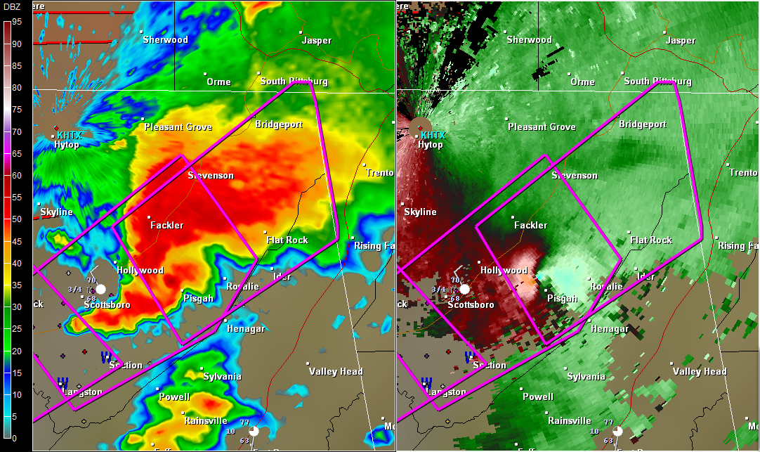
Historic Tornado Outbreak April 27, 2011
Chicago Storm replied to CUmet's topic in Weather Forecasting and Discussion
KBMX from 1-9PM. KHTX, KGWX, KDGX and KFFC would be good sites to load too. -
Historic Tornado Outbreak April 27, 2011
Chicago Storm replied to CUmet's topic in Weather Forecasting and Discussion
Will throw another one up at a later date...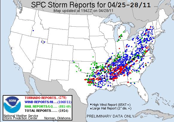
-
Historic Tornado Outbreak April 27, 2011
Chicago Storm replied to CUmet's topic in Weather Forecasting and Discussion
Just catching up on the thread after having to step out several hours ago... Just an amazing event, that's all I can say. -
Historic Tornado Outbreak April 27, 2011
Chicago Storm replied to CUmet's topic in Weather Forecasting and Discussion
-
Historic Tornado Outbreak April 27, 2011
Chicago Storm replied to CUmet's topic in Weather Forecasting and Discussion
BWER on the tor cell near De Kalb, MS...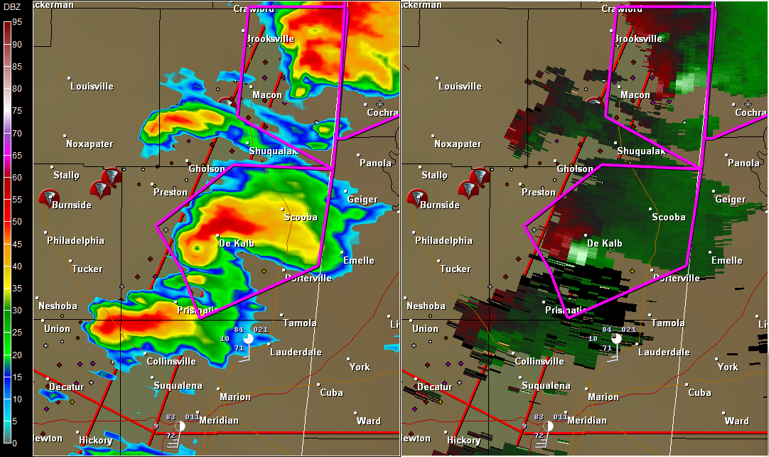
-
Historic Tornado Outbreak April 27, 2011
Chicago Storm replied to CUmet's topic in Weather Forecasting and Discussion
0153 PM TORNADO OXFORD 34.36N 89.53W 04/27/2011 LAFAYETTE MS FIRE DEPT/RESCUE TORNADO TOUCHDOWN WITH DAMAGE. EXTENT UNKNOWN. COUNTY ROADS 369 AND 469 SOUTH OF OXFORD.