

weatherextreme
-
Posts
540 -
Joined
-
Last visited
Content Type
Profiles
Blogs
Forums
American Weather
Media Demo
Store
Gallery
Posts posted by weatherextreme
-
-
Reed has something on stream
-
-
-
Brandon Copic has a wall cloud on stream
-
-
Looks like its a TOG per the met
-
-
36 minutes ago, Quincy said:
SPC has upgraded parts of Kansas and Oklahoma to an Enhanced Risk tomorrow. This includes a significant tornado delineation from south-central Kansas into central Oklahoma.

The greatest risk for scattered to widespread severe thunderstorms appears to be across the western half of Kansas. A more isolated risk is anticipated farther south, but any storms that can initiate could be quite intense. Particularly across the western half of Oklahoma.
Seems to be plenty of these this season that escalate pretty quickly over a 1-2 day period.
-
2 minutes ago, Ed, snow and hurricane fan said:
Looks like it's going to go right through the middle of DFW
-
Warning extended
 Tornado Warning for...
  Central Brown County in west central Texas...

* Until 745 PM CDT.
-
-
637 PM CDT Sat May 6 2023 ...A TORNADO WARNING REMAINS IN EFFECT UNTIL 700 PM CDT FOR NORTHWESTERN BROWN COUNTY... At 637 PM CDT, a severe thunderstorm capable of producing a tornado was located over Byrds, moving northeast at 10 mph. HAZARD...Tornado and golf ball size hail. SOURCE...Radar indicated rotation. IMPACT...Flying debris will be dangerous to those caught without shelter. Mobile homes will be damaged or destroyed. Damage to roofs, windows, and vehicles will occur. Tree damage is likely. This dangerous storm will be near... Byrds around 640 PM CDT. May around 715 PM CDT. -
Some day 2 changes

-
Godzilla about to gobble up DFW
-
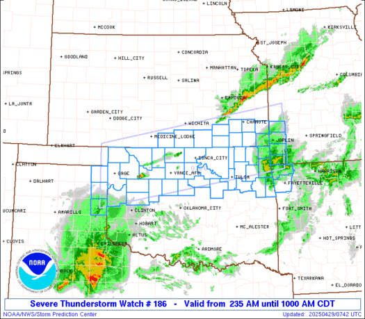
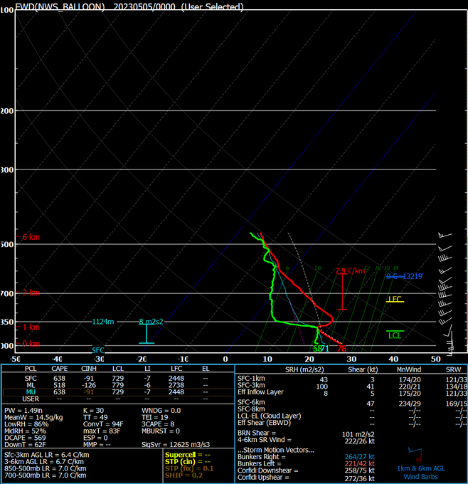
 Concerning...Tornado Watch 185...

   Valid 050013Z - 050145Z

   The severe weather threat for Tornado Watch 185 continues.

   SUMMARY...A cluster of supercells should continue eastward for a few
   more hours with a risk for hail and possibly a couple of tornadoes
   towards the eastern edge of WW185.

   DISCUSSION...Over the last hour, a cluster of supercells in North TX
   has shown signs of intensification with higher reflectively and
   deeper MESH cores noted from regional radar analysis. Additional
   storm development/clustering has also been observed, suggesting
   low-level jet intensification is ongoing. 1000-1500 J/kg of MLCAPE
   should continue to support robust updrafts toward sunset as storms
   move eastward at around 25 kt.

   Current HRRR forecasts and observational trends suggest some upscale
   growth is possible but the storm mode is expected to remain
   primarily supercellular given 40-45 kt of effective shear. Large
   hail will remain possible with these storms given the supercell mode
   and steep mid-level lapse rates near 8 C/km. Some increase in
   low-level shear may also support a couple of tornadoes across
   portions of North TX as backed low-level flow increases and the
   low-level jet intensifies. Given that storms are approaching the
   eastern edge of WW185, a new watch or a local extension may be
   needed across portions of north TX and far southern OK in the next
   hour.
-
Tornado Warned storm is heading towards Thackerville where Winstar casino is located
-
-
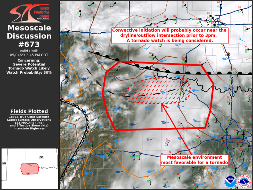
Mesoscale Discussion 0673 NWS Storm Prediction Center Norman OK 0143 PM CDT Thu May 04 2023 Areas affected...northwest TX...far southwest OK Concerning...Severe potential...Tornado Watch likely Valid 041843Z - 042045Z Probability of Watch Issuance...80 percent SUMMARY...Convective initiation will probably occur near the dryline/outflow intersection prior to 3pm. A tornado watch is being considered for portions of northwest TX and immediately adjacent parts of southwest OK. DISCUSSION...Visible satellite imagery shows a towering cumulus field centered on Garza County, TX near a dryline bulge. Surface analysis indicates a messy placement of boundaries across northwest TX and southwest OK. The aforementioned dryline extends southwest from near the Caprock into the Pecos Valley. An outflow boundary extends from the southeast TX Panhandle arching southeast into northwest TX to the south of the Red River, while a synoptic warm front/composite boundary extends eastward near the Red River. Surface temperatures north of the outflow/warm front are in the 60s with 70s nestled in between the warm front and outflow boundary. To the south of the outflow boundary, temperatures have warmed into the lower 80s in locations void of denser mid to high-level cloud cover. Surface dewpoints are in the lower 60s east of the dryline from near San Angelo to north of Abilene. Additional heating will occur as the cirrus shield over western north TX shifts east and upwards of 1500 J/kg MLCAPE is forecast by mid afternoon. Effective shear will support a supercellular mode. Large to very large hail (diameters 1 to 2.5 inches) and a tornado are possible with storms that manage to mature and optimally interact in the vicinity of the west-east oriented low-level boundaries. ..Smith/Thompson.. 05/04/2023 -
Reed believes the storm he is on could possibly produce a Tornado
-
 1
1
-
-
-
Reed just confirmed TOG on stream
-
Think it was mentioned from Reeds stream that they have a rain wrapped Tornado or wall cloud
-
-


Texas/Oklahoma 2023 Obs and Discussion
in Central/Western States
Posted
Tornado on Reeds stream