
NJwx85
-
Posts
15,544 -
Joined
-
Last visited
Content Type
Profiles
Blogs
Forums
American Weather
Media Demo
Store
Gallery
Posts posted by NJwx85
-
-
3 minutes ago, bluewave said:
It’s an impressive warm signal to start March. As the El Niño begins to fade, the northern branch of the Pacific Jet becomes active again. So the ensembles have a twin Pacific jet extension of both branches. This is followed by a deep trough out West and Southeast ridge pattern taking hold to start March.

We deserve a nice and mild start to Spring after the last few years.
-
 2
2
-
-
The 12z RGEM has a really solid event here.
Around 0.2 to 0.3" QPF could easily be a 3-5" event with high ratios expected.
There should be a quick moving area of enough lift to give a few hour burst of moderate to locally heavy snow.

-
4
-
 1
1
-
-
4 minutes ago, BxEngine said:
Got 1/2” the last 40 minutes a few miles from you. That band is expanding though. Hopefully for a few hours.
I think we’re good for the next 4 hours or so. After that the back edge will be rapidly approaching.
-
I was pretty much on board with NYC snow yesterday but was skeptical that rates would be heavy enough along the coast to overcome BL issues enough to get over 6”. Clearly the models were too weak and too far South with the banding. Kudos to the GFS and Canadian models which never shifted like the Euro and NAM did.
I always say how unstable the NAM is but people here love it because it often shows them what they want to see only to completely change most times a run later.
-
About 4” here so far on elevated cold surfaces like my patio table. About half that on the ground. Very light snow here currently and 30 degrees.
-
1
-
-
-
12 minutes ago, Greg g said:
So I had a flight tonight from Orlando at 8pm landing at LaGuardia at 10:30 that got canceled.
the airlines rebooked my flight at 8:00am going to Atlanta… I then leave Atlanta at 10:30 getting to LaGuardia at 12;45… will it be fine by then at 12:45??
Here's the incoming flight into Orlando.
https://www.flightaware.com/live/flight/DAL2082/history/20240212/2100Z/KLGA/KMCO
They will probably reassign the aircraft to a different route.
All of the airlines are going to be pulling assets out of the NY airports until things settle down.
-
1 minute ago, gravitylover said:
They don't want the plane stuck on the ground in NY
They do this a lot. Trying to mitigate problems down the line, however they haven't cancelled anything for tomorrow morning yet.
-
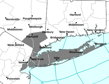
How many of these winter storm warnings will be dropped completely or downgraded by tonight?
-
1
-
-
2 minutes ago, allgame830 said:
In all fairness the last school closing the forecast was 2-4/3-6 so why wouldn’t they close this time. I understand your point.
If 2-4 or 3-6 ends up verifying then fine. We could end up with way less than that up here.
-
Don't be surprised when the 00z runs end up even further South.
Most school districts around here have already called closings for tomorrow.
I understand what the forecast was showing but there was no need to pull the trigger this early.
-
1
-
-
2 minutes ago, ag3 said:
3km NAM is also amazing for the NYC metro and south.
If that's your take you really do need to go back to school and learn geography.
-
-
The 18z NAM closes off this run over Northern Virginia which kind of drags the entire precip field South some. It's more consolidated. Definitely not a great trend for areas North of I-84.
-
1 minute ago, nycsnow said:
Imagine we had a good airmass..
You have a Southeasterly flow to start which doesn't flip around until the low passes offshore. If you had a really strong high to the North Philly and DC would be getting snow and NYC would be on the Northern fringe instead of Albany.

-
3
-
-
1 minute ago, jm1220 said:
Mid level lows show how this CCB might really happen. Looks good at 500/700mb.
The mid level lows close off in a very good spot for heavy snow in our area. And the low is still deepening as it passes to our South. The system doesn't occlude until it's way up in Canada.
-
3 minutes ago, wishcast_hater said:
LOL - Backend Snow.
.This is a full blown coastal system with a mature CCB.

-
4
-
-
17 minutes ago, Dark Star said:
Any type of dry slotting with marginal temperatures spells no accumulation for coastal areas...
To be fair, the dry slotting would be temporary following by several hours of backend snow as the system moves East.
You can kind of see the possible dry slot here on the 12K NAM.
For areas along I-80 and points North this is going to be a very big snow storm.

-
1
-
-
This isn’t a late season storm. We have a long history of getting big snows in mid February. We have about another month. After March 10th it’s pretty much over for I95 unless we end up with a very anomalous pattern.
Given recent model trends and a significant shift southwards, closed 700mb low South of LI favors a band of heavy snow tomorrow for a few hours near I-80/287. Wouldn’t be surprised to see a few 12”+ reports especially in the higher elevation areas of NW NJ into Orange County, NY.
I like 4-8” for the Bronx and Southern Westchester. 6-12” North of HPN. 3-6” for Central Park and 2-4” for South facing Brooklyn and Queens. There will be a Southerly flow to start which will cause mixing issues and the 700mb low close proximity could cause dry slotting in Central NJ and South shore of LI.
Could be one of those storms where SI sees 3-5” and Sandy Hook gets nothing.
-
5
-
-
7 minutes ago, SBUWX23 said:
Not sure what's going on there but the point click ranges seem broader then the maps do.
My point and click in Southern Rockland is 4-8” and WSW.
-
14 minutes ago, the_other_guy said:
yeah, next week and the extreme warmth is a real kick in the balls in the heart of winter
If you believe the GEFS, the above normal temps rebuild for the beginning of February. If you consider that normal for NYC around then is about 40 degrees we could be easily in the 60's if it verifies.
-
3 minutes ago, Brian5671 said:
Hopefully we get another period in Feb otherwise it's a 01-02, 11-12 style winter with a 7-10 day stretch in Jan and then torch rest of way
We're only about a month away from the sun angle becoming an issue. Really is remarkable how short the big snow season is around here. Most of December is pretty much lost and then you get that period between Christmas and say Presidents Day that I refer to as the meat of the snow season and then it's over, especially for the coast. Doesn't mean we can't have a snowy March. If I recall March 2017 was very snowy but I'm fairly certain that was a La Nina.
-
Nothing but white rain here all day. Not going to stick to pavement especially with all of the salt still present from Monday.
Hard to believe that this pattern didn't deliver a big one after all of those cutters but it is what it is. GFS has above average temps through at least the first week of February from here on out.
-
2
-
-
The ARW models actually bring the 2" line North of 287 with a 10:1 ratio. I guess if that verified 2-4" could be realized.
-
1
-


February 2024
in New York City Metro
Posted
Prime snow season ends around here the middle of next week. After that sun angle becomes a growing problem for anything that falls during the day. Heck, it was even somewhat of an issue yesterday in the immediate costal plain and the city.