

ragtop50
-
Posts
142 -
Joined
-
Last visited
Content Type
Profiles
Blogs
Forums
American Weather
Media Demo
Store
Gallery
Posts posted by ragtop50
-
-
RAH update, mentions the updates to warnings would later if done
.NEAR TERM /THROUGH TONIGHT/... As of 930 AM Friday... Just minor changes this morning as we await a full suite of new 12z- initialized guidance. Observational datasets confirm the near term forecast trends. The latest surface analysis shows the frigid high nosing strongly down through central NC with plenty of dry air advection, including single-digit dewpoints just to our N. Skies are just cloudy, with radar showing spotty elevated returns across the S half, although most of this is likely not reaching the ground given the somewhat dry subcloud layer noted on 12z soundings. Will maintain low chance pops across the SE well into the afternoon, before trending pops up with a NW expansion as we approach the evening. Any changes to the advisory or warning will wait a few more hours when further high res guidance can be fully considered. Expect temps to hold firm or rise just a degree or two today, yielding daytime highs of 27-34. Current brisk winds from the NNE and NE with occasional gusts to around 20-25 mph will persist through the day as the dense air pours in with a strong ageostrophic component, which will keep wind chills in the upper teens to mid 20s for much of the day. -GIH -
1 minute ago, VABILLUPS1 said:
I'm stunned - I have no idea what's going to happen. NAM-GFS are out, ICON/RGEM holding steady. I'll just wait and see at this point.
I am not sure that having those two in your camp vs GFS/NAM is a great position to be in, I feel your pain
-
-
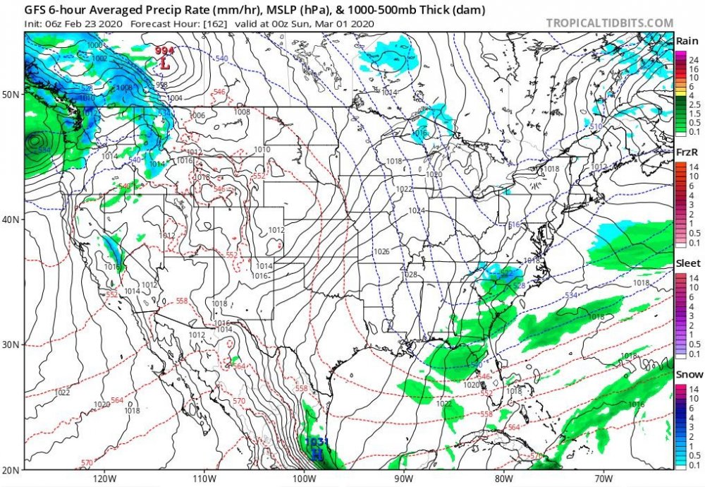
GFS is trying for March 1st
-
 3
3
-
-
1960, 1980, 2000...
Continue that trend....we are due !
Not all were March but big snows those years
-
2
-
 1
1
-
-
2 minutes ago, TARHEELPROGRAMMER88 said:
NAM is warmer it appears so far through 18 and also less QPF. This could be a precursor to a big bust for most of NC. Ouch. Someone will get some snow though.
Funny, all of the analysis I have seen so far say it is colder
-
1
-
1
-
-
13 minutes ago, Tarheel17 said:
Good observation. Hickory has a DP of 22 while KCLT has a DP of 34 as of an hour ago. Hope to see that DP drop some more before the precip starts flowing in tomorrow morning.
It will be interesting to watch those actual dew points in comparison to where the NAM says they would be. They look to be ahead of schedule and lower than predicted off to the NW. Mt Airy shows a dew point of 11 as of last report on NWS
-
We need some of the lower dew points to keep filtering down into central NC. DPs still in 30s Raleigh and south, but 20s to even single digit DPs off to the NW of there. That is the critical piece I will be watching to get an idea of how well the cold air is working in. Obviously not too far to our NW
-
1
-
 2
2
-
-
ABC11 (WTVD) says the southern part of central NC is the wildcard depending on how fast it changes over from rain/mix to snow. The comment was that it could be a bit more accumulation than shown because the timing in that area is hard to nail down and will have plenty of moisture on hand.
-
2 minutes ago, BullCityWx said:
GFS has us at 100% overcast the entire night
Radiational cooling will do wonders for surface temps, I am hoping it will clear out some and allow that
-
2 minutes ago, RT1980 said:
Wouldn’t higher precip amounts lead to more cooling?
But also can lead to more of a warm nose with a more amped system
-
1
-
-
ABC11 (WTVD) actually showed the output from the NAM but discounts the amounts. They say what is important from the NAM is that the main area with a threat of the most snow lines up fairly well with other models. Still conservative at 1" or less, but did say that a large area east of Raleigh has a 40% chance of 1" or greater.
-
 1
1
-
 1
1
-
 1
1
-
1
-
-
1 minute ago, StantonParkHoya said:
The point being that cold transport can work. 1989 cold followed days after the snow began.
But it was record cold in place PRIOR to the snow, which makes all the difference down here
-
RAH not biting:
Mid and high level moisture will increase rapidly on Thursday ahead
of a positively tilted trough digging through the Midwest.  Precip
will spread along the stalled frontal zone over the SE US, with
cyclogenesis induced off the SE coast.  Models continue to trend a a
bit closer to the coast with the surface low bringing more moisture
inland.  The low is still relatively weak, however, and moves east
with the digging trough.  The bigger question is whether or not the
arctic air associated with a 1045+ mb high over the central US will
spill across the mountains in time to cause a mix of rain and snow
or changeover to rain.  The high is not in a favorable location for
the dense cold air to make it into NC very quickly...likely having
to filter across the central Appalachians and south through VA...and
so the probability of probability more than a rain/snow mix appears
very low at this time.  If there is an opportunity for phasing of
sufficiently deep moisture/omega and cold air, it would be north and
east of the Triangle, which is where the outlier EPS solutions
lie..while the the GFS and GEFS appear to be too aggressive with
with cold air.
-
RAH discussion this afternoon concerning next week:
The aforementioned cold front/frontal zone is expected to settle to
the south of the area on Wednesday into Thursday as cold high
pressure builds into the area. The will allow for high temps to be
in the 40s late week, with low temps possibly in the 20s by Friday
morning. With regard to chances for precip, additional s/w energy is
expected to dive south/southeastward out of the upper Midwest and
potentially drawing the stalled front to the south back northward
and allowing for chances for precip Wednesday into Thursday, with
dry weather expected again by Friday. The latest ECMWF keeps central
NC dry (with any precip to the south), while the GFS spreads precip
into our area. If precip does spread back into our area, we could
see a threat for some wintry precip, with possibly even some snow
across our area (even southern locations). Thus, there remains a lot
of uncertainty in this portion of the forecast, but will keep the
precip all liquid in the forecast for now and lower temps some. Stay
tuned.
-
3 hours ago, yotaman said:
Yes it did. Hit 80 at my house and across much of southeastern NC and eastern SC.
Mid 70's here as well
-
1
-
-
14 minutes ago, mackerel_sky said:
Don’t sleep on the 7th! GFS is still interesting on 12z! Cold looks about as good as we can get, moisture is around...
I was just looking at that, worth keeping an eye on it.
-
1
-
-
Looks like the 2020 Mid to long term thread has been started !
-
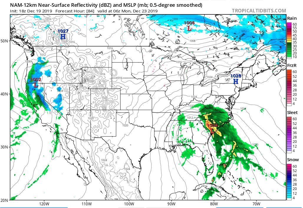
Purely from an educational standpoint (to help me and others learn), why would the below scenario depicted by the NAM not be showing more frozen precip in NC and VA? We always here a low off/near the coast just to our SE with a HP just to our north is the perfect setup. I realize the NAM may be off base here (and that it is the NAM at hour 84), but with what it is showing, why is the setup all or mostly rain? Is it because the HP to the north is not strong or cold enough?
 enough?
-
I want to think this is caused by cycles with our weather, certainly history has shown periods like this before? I hope to see the some of the good winter storms of past to return one day. They are even more rare for my area (Fayetteville/Linden), but we can get some good snow from the right setup.
-
3 minutes ago, StantonParkHoya said:
Or the Atlantic, which is the number one reason for moderating temps and mix lines at NC latitude.
But the Atlantic can also be the reason we can score a big one...coastal storms. I have lived in central NC my whole life, and the best snows have been due to a coastal storm as it rides up the coast. But in agreement, probably more times than not, it is that source for the warm air surging inland and turning everything to rain.
-
1
-
-
1 minute ago, NCSU_Pi said:
I think when people refer to the daily record, they probably mean the record on that day. Fran was hitting Wilmington on 9/5.
Ah, I see
-
29 minutes ago, donsutherland1 said:
With 0.78" rain over the past 40 minutes, Wilmington's daily rainfall has reached 4.44". That surpasses the daily record of 4.41", which was set in 1996 as Hurricane Fran was moving toward landfall.
I thought Wilmington received 26" of rain with Florence last year? I know that was over multiple days but I would have thought the daily record would have been shattered during Florence?
-
12 minutes ago, rowjimmy73 said:
my curiousity is, when wil the transition to extra tropical begin, will we see a transition of the rain shield to the nw once it get to the nc coast or will it stay mainly east sided
This /\ /\ made all the difference with Matthew (as far as heaviest precip being on the west side). I live near Fayetteville, NC and watched what that can do first hand
January 20-22 “bring the mojo” winter storm threat
in Southeastern States
Posted
Few flakes flying around here just north of Fayetteville in Linden (northern Cumberland County)