

Tibet
-
Posts
279 -
Joined
-
Last visited
Content Type
Profiles
Blogs
Forums
American Weather
Media Demo
Store
Gallery
Posts posted by Tibet
-
-
11 minutes ago, RedSky said:
12z runs bring the precipitation back quicker and more robustly into the retreating cold is the biggest difference over 0z
To clarify, that translates to an earlier start to the second round event?
-
Absolutely ripped through the Easton area. Shortlived but definitely impressive.
-
 1
1
-
-
Just drove from reading up 222 to 78 back to the Easton area. What would normally take an hour took two. 78 was surprisingly bad.
-
If the HRRR is to be believed I should be dropping ~10 in less than 2 hours... Good luck to all my neighbors who haven't cleared their cars off.
-
Straight rain just south of Easton.
-
Light snowing continuing just south of Easton. HRRR shows frozen precip until about 11pm-12am...
-
16 minutes ago, Newman said:
Sorry Redsky.

What kind of time frame is this modeled to happen over? Shift that a little east and the Lehigh Valley will definitely be beating the 3 foot we got some years back
-
411
NWUS51 KCLE 021850
LSRCLE

PRELIMINARY LOCAL STORM REPORT
NATIONAL WEATHER SERVICE CLEVELAND OH
250 PM EDT TUE OCT 2 2018

..TIME...   ...EVENT...      ...CITY LOCATION...     ...LAT.LON...
..DATE...   ....MAG....      ..COUNTY LOCATION..ST.. ...SOURCE....
            ..REMARKS..

0245 PM     TORNADO          5 E CONNEAUTVILLE       41.76N 80.27W
10/02/2018                   CRAWFORD           PA   TRAINED SPOTTER

            CONFIRMED TORNADO. NURSING HOME STRUCK BY TORNADO.


&&

$$

LOMBARDY
That doesn't sound good
-
I'd bet that this is related to flooding taking out the tracks.
http://www.fox46charlotte.com/news/local-news/train-derailment-in-anson-county
photos look like it was a pretty dramatic event.
-
Anyone see this? Suprised there were this many aircraft present... assuming they were airworthy, to begin with.
737 NWUS52 KILM 151807 LSRILM PRELIMINARY LOCAL STORM REPORT...CORRECTED NATIONAL WEATHER SERVICE WILMINGTON NC 207 PM EDT SAT SEP 15 2018 ..TIME... ...EVENT... ...CITY LOCATION... ...LAT.LON... ..DATE... ....MAG.... ..COUNTY LOCATION..ST.. ...SOURCE.... ..REMARKS.. 1000 AM TROPICAL STORM 4 E MARION 34.18N 79.33W 09/15/2018 MARION SC MEDIA MARION COUNTY AIRPORT - 3 TO 4 HANGARS COMPLETELY DESTROYED. AT LEAST 4 ROBINSON HELICOPTERS, A FIXED-WING AIRPLANE, AND AN ULTRALIGHT AIRCRAFT SUSTAINED SIGNIFICANT DAMAGE. DAMAGE OCCURRED BETWEEN LAST NIGHT AND THIS MORNING. && CORRECTED REMARKS EVENT NUMBER ILM1800213 $$ OLIVA -
53 minutes ago, Hurricane Agnes said:
Hurricane Ivan did it in 2004, although the path was a bit different (and they do usually keep the same name as long as it didn't completely dissipate) -

The million dollar question though... do we keep the same thread here

-
1
-
 2
2
-
 1
1
-
-
1 minute ago, nchighcountrywx said:
Is there a public link to the Goes 17 Image Viewer that you are showing us? Thank you.
-
 2
2
-
-
Just now, Snow88 said:
I'm a big winter weenie
And when you end up east of a cutoff like 3 times this winter?
-
3 minutes ago, TPAwx said:
That’s an unfortunately shaped graphic.
No... it is glorious.
-
1
-
-
1 minute ago, Snow88 said:
God i miss winter
You say that now
-
11 minutes ago, Windspeed said:
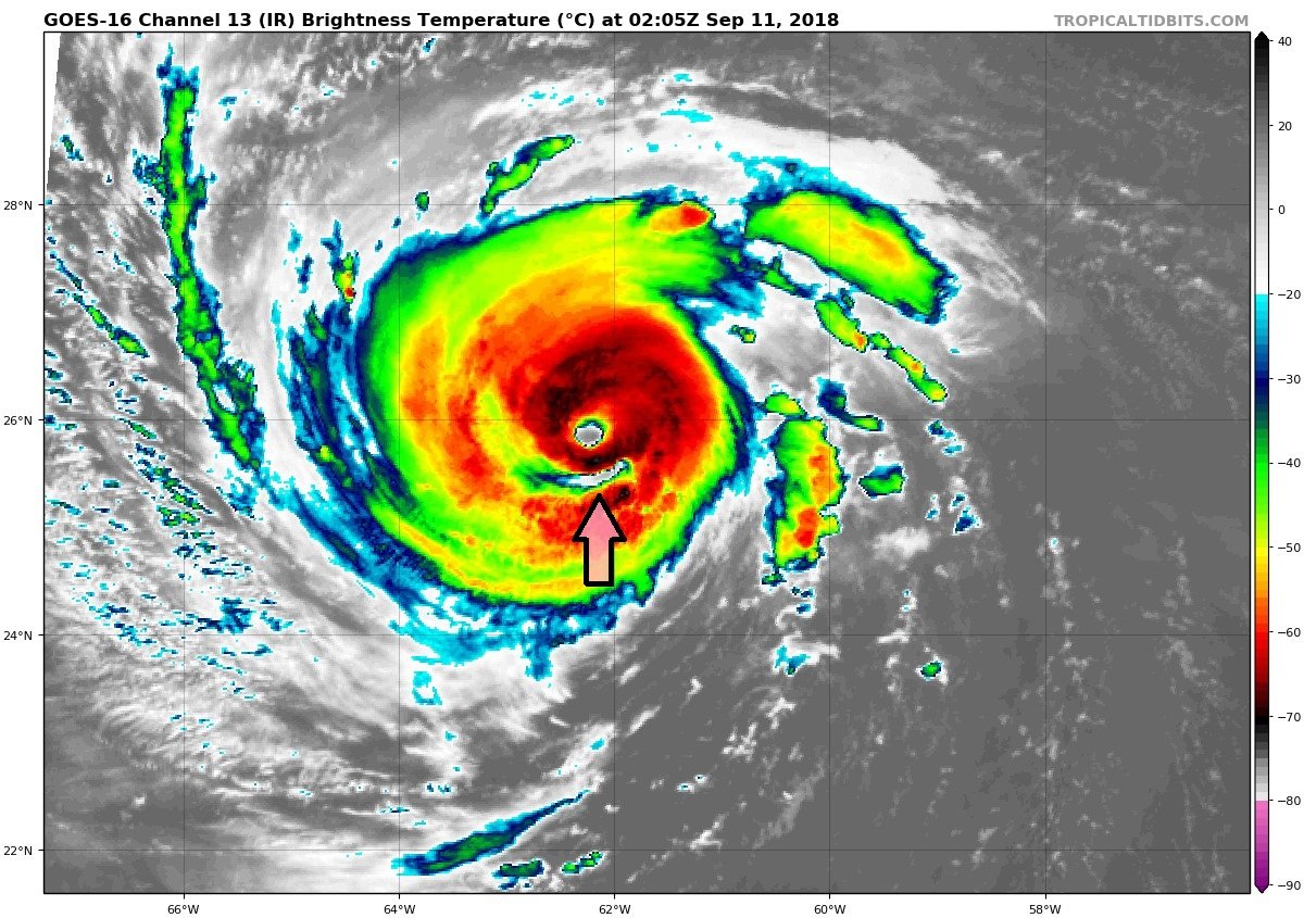
Strong convection in the southern band. Even looks like it is creating a moat of subsidence outside SW portion of the eyewall. Even though Florence has a decent-sized eye, don't be surprised at another ERC cycle and an even larger eye. The current eye also does look to be contracting a bit.

Maybe I live under a rock but this storm is the first time I have ever seen this phenomenon, occurred at one point last evening.
-
And can anyone describe what is occurring just south of the eye?

-
Can anyone explain the reduction in banding that seems to be occurring on IR?
-
3 hurricanes in the Atlantic right now, any idea what ACE is to date?
-
15 minutes ago, Hoosier said:
So with Florence looking to jack up a good portion of coast, what do you guys think about whether so much development should be allowed so close to the water?
Based on history, it is known that hurricanes come calling every so often. Obviously factors like location and shape of the coast affect the risk in any particular area, with some areas of the coast being more susceptible than others. Compare that to tornadoes in which you don't know exactly where they are going ahead of time, and even in the prime tornado region of the country, the average recurrence at any particular point location is something like once every several hundred or even 1,000+ years (there are always freak exceptions of the same house getting hit twice in 5 years or whatever).
Frankly allowed or not eventually it will become impractical if you want any form of insurance. Insurance companies will eventually drive the change but before it gets a real kick in the ass something truly catastrophic will have to happen... not some seasonal vacation home disappearing but beachfront Miami getting wiped out.
-
5 minutes ago, HarveyLeonardFan said:
Despite the beauty of the satellite presentation at landfall and pressure comparable to Andrew I'm not seeing damage comparable to Andrew in any way, shape, or form. I was in south Dade a month after Andrew and that hurricane destroyed entire shopping centers just as Katrina destroyed entire shopping centers on just about the entire length of the Mississippi gulf. Maria did not pack this kind of punch. I believe Andrew was a once in a thousand year storm and that Katrina s Mississippi surge was a once in a 500 year event.
Have we actually gotten reliable damage reports out of the south-east of PR? I keep seeing San Juan... but they likely didn't get the worst of the storm.
-
6 minutes ago, Windspeed said:
The next pass may miss the entire island or get all of it. There are several polar orbiting satellites that scan. I haven't studied their time syncs, I generally just check at random times. It's difficult to get the rain rate product scan where you want it.
Ever tried Gpredict? Have never looked for these particular sats but ya may be able to better predict passes with it (better than guessing anyway).
-
1
-
-
30 minutes ago, 40/70 Benchmark said:
Agree....I don't think its a major threat.
Not sure I agree with this. The storm may never be what it once was, but it doesn't take a cat 4 or 5 to cause tremendous issues in the mid-Atlantic and north.
-
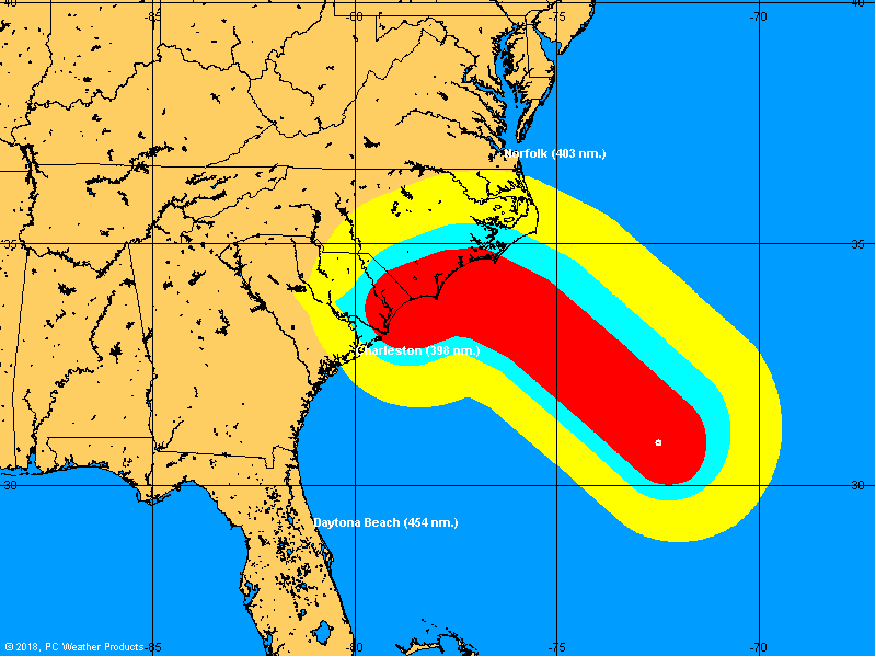
EURO hr144, ridge stronger with Jose nowhere insight to open the door?
Winter 2018-19 Banter Thread
in Philadelphia Region
Posted