

Tater Tot
-
Posts
298 -
Joined
-
Last visited
Content Type
Profiles
Blogs
Forums
American Weather
Media Demo
Store
Gallery
Posts posted by Tater Tot
-
-
Odd how transient the rotation was on the Stafford cell. Appeared and disappeared within one scan. I guess they don't call them brief spinups for nothing.

-
2 hours ago, the ghost of leroy said:
no ERC issues in the WPAC tho

Looks just like Irma!
-
42 minutes ago, GunBlade said:
There’s some shear that probably won’t last much longer. The water vapor loop shows it well.

If it comes ashore looking anything like that, Josh is going to vomit.
-
 2
2
-
-
10 minutes ago, JoshM said:
 People still running around here for supplies. Only way the power is going off here is if you don't pay the bill.
I can't decide in which Carolina that would be more likely.
-
WHAT is WRONG with all of you? You WANT a category 5 hurricane? You want people to DIE? To have their HOMES DESTROYED? How can you even LIVE WITH YOURSELVES IS BEYOND ME AND I HOPE THAT THIS impression was enough to meet the forum's moral outrage quota and if we're lucky we won't have to see any of its kind for a good 12 hours or so.

-
1
-
-
Ohhhh... NJwx85 is the guy I was talking about on the first page who used to have a wedding photo as his avatar. It all makes sense now.
-
1
-
-
3 minutes ago, the ghost of leroy said:
he is full of it and most longtimers here know that he's the worst mod. not scared of burns at all when i have a direct line to the boss.
i am not afraid to tell people who are trash posting about irma that they should stop. the same 10 weenies ruin every event.
This is why I love this place.
-
1 hour ago, the ghost of leroy said:
then get these people under control. the comparisons to irma based upon looks alone are worthless.
1 hour ago, jburns said:I'm going to start with you.

-
48 minutes ago, bobbutts said:
What's the best site to get GOES-16 loops/images?
Don't know about the best, but this is the easiest to navigate imo:
-
1
-
-
What ever happened to that guy who posted a lot in the tropical threads last year, who iirc had his wedding photo as his avatar?
-
8 minutes ago, Kmlwx said:
Quite the storm here in Potomac. Close lighting strike scared our receptionist while I was standing with her at the windows in the waiting area.
-
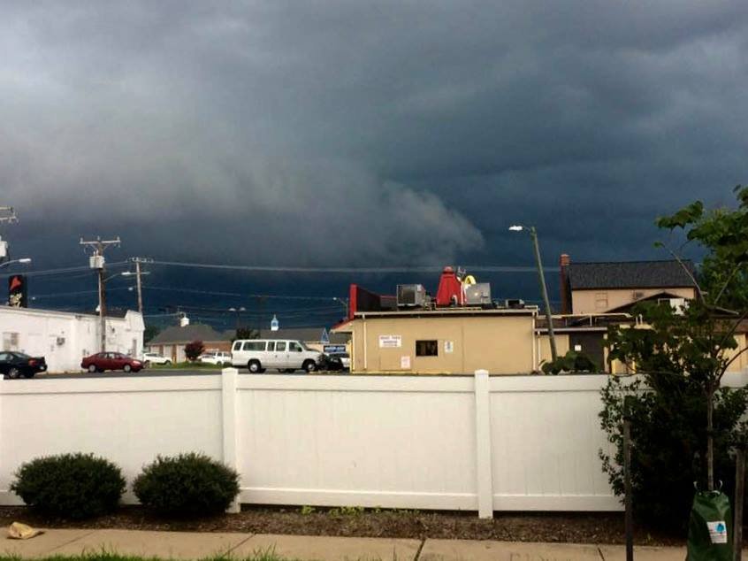
My mom took this while she was out getting her steak. Apparently, downtown Fredericksburg has tornado sirens now! Now I’m disappointed I didn’t go with her. I would have loved to have heard that in real life.
-
1
-
-
We really hit a jackpot here. I'd honestly say the most impressive thunderstorm I've been in since the derecho. Power is out, trees are down, roads are flooded, weather weenie is throbbing!
Corresponding with the worst winds (around 4:35) the radar velocity showed some green patches within the red, just north of where I live. Nothing impressive but makes sense because the direction of the winds had practically no consistency at all.
I was hoping to drive around and get pictures but I'm stuck between road closures. Recorded most of it from the window because I'm itching for a Darwin award but it was pretty much a whiteout during the worst of it so the footage probably isn't any good. Oh well. My mom made it back home with her steak just minutes before the first gusts, so a happy ending for everybody!
...Well, except I guess for the losers who only got a few thundershowers.

-
1
-
-
1 minute ago, yoda said:

Severe Thunderstorm Warning
VAC047-061-137-177-179-122015-
/O.NEW.KLWX.SV.W.0226.180812T1903Z-180812T2015Z/

BULLETIN - EAS ACTIVATION REQUESTED
Severe Thunderstorm Warning
National Weather Service Baltimore MD/Washington DC
303 PM EDT SUN AUG 12 2018

The National Weather Service in Sterling Virginia has issued a

* Severe Thunderstorm Warning for...
  Southwestern Stafford County in northern Virginia...
  Northeastern Orange County in central Virginia...
  Southeastern Fauquier County in northern Virginia...
  Southeastern Culpeper County in northern Virginia...
  North central Spotsylvania County in central Virginia...

* Until 415 PM EDT.

* At 303 PM EDT, a severe thunderstorm was located 8 miles east of
  Culpeper, moving east at 15 mph.

  This is a very dangerous storm with a history of producing wind
  damage. SEEK SHELTER IMMEDIATELY!

  HAZARD...80 mph wind gusts and tennis ball size hail.

  SOURCE...Radar indicated.

  IMPACT...Expect considerable damage to trees and power lines. You
           life is at significant risk if outdoors. In addition to
           some trees falling into homes, wind damage is possible to
           roofs, sheds, open garages, and mobile homes.

* Locations impacted include...
  Remington, Elkwood, Stevensburg, Roseville, Lois, Flat Run,
  Chancellorsville, Ramoth, Heflin, Lignum, Storck, Holly Corner,
  Dunavant, Glendie, Richardsville, Morrisville, Hartwood, Goldvein
  and Sumerduck.

PRECAUTIONARY/PREPAREDNESS ACTIONS...

Remain alert for a possible tornado! Tornadoes can develop quickly
from severe thunderstorms. If you spot a tornado go at once into the
basement or small central room in a sturdy structure.

This is a potentially deadly storm. Seek shelter in an interior room
on the lowest floor of a well-built structure. Abandon vehicles in
search of a more substantial permanent structure. Stay away from
windows.

&&

LAT...LON 3844 7793 3855 7786 3847 7743 3827 7757
TIME...MOT...LOC 1903Z 291DEG 12KT 3846 7785

TORNADO...POSSIBLE
HAIL...2.50IN
WIND...80MPH
And my mom is out in this because she wanted a prime rib from Outback.
-
 1
1
-
-
Whoa, that hail core that showed up NE of Culpeper on the 3 PM scan is sick.
-
The hook on the 12:55 scan was really nice.
-
Just now, WxWatcher007 said:
Definitely some rotation IMO.

They did the "Tornado: Possible" thing with the STW, so I've been more moronic before!

-
Does the cell near Orange have a little rotation on it or am I being a moron?
-
44 minutes ago, Stormpc said:
That Meso reads like a Penthouse Forum for weather enthusiasts. Wow.
Dear Weather Prediction Center, I never thought this would happen to me...
-
2
-
-
This reminds me a little bit of that coastal storm we got that seemed to linger over us for days back in late September of 2008. Anyone know what I'm talking about? The wind was a little bit stronger with that one but the steady, dreary rain and the 'Feel' outside was similar. If I woke up from a coma and walked outside today I would have bet money that it was September.
-
And then we'll probably have some freak heat wave in December where we actually get the July-ish temperatures. Welcome to Virginia!
-
Not too shabby looking.
-
3
-
-
4 hours ago, Eskimo Joe said:
Yea, there is a weak relationship between flash flooding and a few kidney beans trying to spin during these set ups.
Wait, really?
Just the connection to tropical remnant spinups or something different?
-
These suckers are moving fast:
QuoteAT 728 PM EDT, A CONFIRMED TORNADO WAS LOCATED NEAR FORKS OF BUFFALO, MOVING NORTH AT 50 MPH.

September Discobs Thread
in Mid Atlantic
Posted
That TW that just expired for the Falmouth area is the first time in awhile that I've seen the "Locations impacted" tag mention my community. Ironically, the closest my area has ever come to a tornado was also on a September 17th.