

AlexD1990
-
Posts
655 -
Joined
-
Last visited
Content Type
Profiles
Blogs
Forums
American Weather
Media Demo
Store
Gallery
Everything posted by AlexD1990
-
That was god tier posting.
-
^February would be rockin LOL. Tangentially related, but Dan Satterfield(Local on-air Met) posted on his social media today a very(for him) bold call/higher than normal possibility of a possibly snowy winter, and even went so far as to invoke 09-10..
-
77 Sent from my SM-F711U using Tapatalk
-
Local Mets mentioning the remnants loop back and hit as another nor easter next weekend Sent from my SM-F711U using Tapatalk
-
Wind is howling in bursts in Angola, Delaware (just inland of dewey Beach on rehoboth bay) We bought a trailer this spring and how anyone could feel safe in anything stronger than this is amazing to me, there's been several gusts where I have wondered if it's going to flip over. Not the best nights sleep. ... Sent from my SM-F711U using Tapatalk
-
They've been playing that at my work
-
Some of the local TV mets were mentioning this on social media yesterday. Definitely not a hazard I was initially prepared to be dealing with...
-
Sandy, Irene, and blizzard of 2016, if I read the info graphic correctly Sent from my SM-F711U using Tapatalk
-
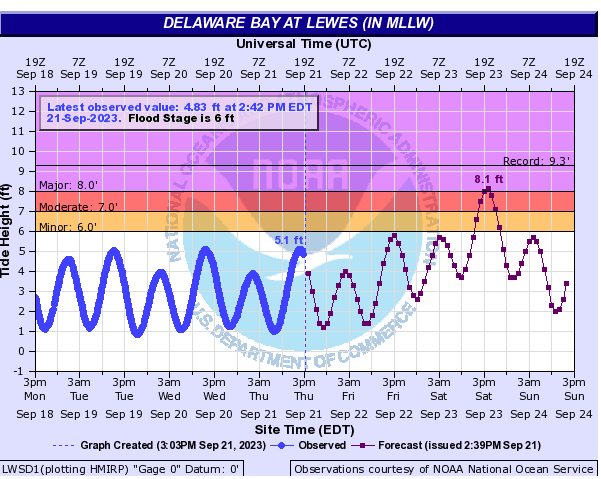
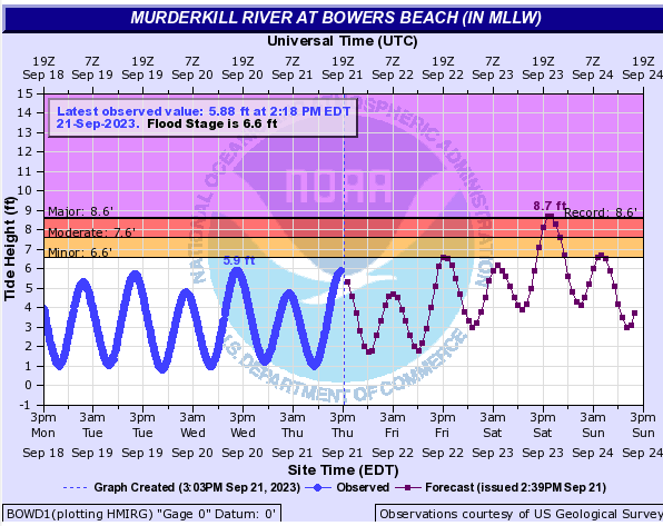
Record or near-record flooding now forecast along the Delaware Bay:
-
WOW. Definitely making up for lost time on that advisory!
-
Agreed. From the standpoint of the general public(if they're even paying attention), it would seem to be confusing..
-
I can't remember the last time they moved so quickly through the stages. We went from a 40% orange to advisories on a PTC in what, an hour??
-
Maybe Isaias or Elsa?
-
How much credence can we lend to the NAM, though? Still eyebrow-raising, nonetheless..
-
Good to remember for winter... Sent from my SM-F711U using Tapatalk
-
The main thread is unreadable Sent from my SM-F711U using Tapatalk
-
This thing has now caused several thousand deaths in Lybia Sent from my SM-F711U using Tapatalk
-
2023 Mid-Atlantic Severe Wx Thread (General Discussion)
AlexD1990 replied to Kmlwx's topic in Mid Atlantic
Now a tornado warning on the eastern shore Sent from my SM-F711U using Tapatalk -
New advisory out: Hurricane Lee Advisory Number 9 NWS National Hurricane Center Miami FL AL132023 1100 AM AST Thu Sep 07 2023 ...LEE RAPIDLY STRENGTHENING... ...LARGE SWELLS LIKELY TO REACH THE LESSER ANTILLES, THE VIRGIN ISLANDS, AND PUERTO RICO THIS WEEKEND... SUMMARY OF 1100 AM AST...1500 UTC...INFORMATION ----------------------------------------------- LOCATION...16.4N 50.0W ABOUT 870 MI...1405 KM E OF THE NORTHERN LEEWARD ISLANDS MAXIMUM SUSTAINED WINDS...105 MPH...165 KM/H PRESENT MOVEMENT...WNW OR 295 DEGREES AT 15 MPH...24 KM/H MINIMUM CENTRAL PRESSURE...983 MB...29.03 INCHES WATCHES AND WARNINGS -------------------- There are no coastal watches or warnings in effect. Interests in the northern Leeward Islands should monitor the progress of Lee. DISCUSSION AND OUTLOOK ---------------------- At 1100 AM AST (1500 UTC), the center of Hurricane Lee was located near latitude 16.4 North, longitude 50.0 West. Lee is moving toward the west-northwest near 15 mph (24 km/h), and this motion is expected to continue through Friday. A slower motion toward the west-northwest is forecast over the weekend. On the forecast track, the core of Lee will move north of the northern Leeward islands during the next few days. Maximum sustained have quickly increased to near 105 mph (165 km/h) with higher gusts. Rapid intensification is expected today and tonight. Lee will likely become a major hurricane later today. Lee is forecast to remain a very strong major hurricane through the weekend Hurricane-force winds extend outward up to 25 miles (35 km) from the center and tropical-storm-force winds extend outward up to 90 miles (150 km). Sent from my SM-F711U using Tapatalk
-
2023 Mid-Atlantic Severe Wx Thread (General Discussion)
AlexD1990 replied to Kmlwx's topic in Mid Atlantic
Maybe even rotation on the cell near Nokesville? Sent from my SM-F711U using Tapatalk -
2023 Mid-Atlantic Severe Wx Thread (General Discussion)
AlexD1990 replied to Kmlwx's topic in Mid Atlantic
Multiple tornado warnings in SoMd Sent from my SM-F711U using Tapatalk -
2023 Mid-Atlantic Severe Wx Thread (General Discussion)
AlexD1990 replied to Kmlwx's topic in Mid Atlantic
Looks like a small hook developing near Taneytown Sent from my SM-F711U using Tapatalk -
2023 Mid-Atlantic Severe Wx Thread (General Discussion)
AlexD1990 replied to Kmlwx's topic in Mid Atlantic
Now a tornado warning Sent from my SM-F711U using Tapatalk -
Tornado watch just to the south Sent from my SM-F711U using Tapatalk
-
Got dark as night here before it hit. Torrential rain and some gusts probably in the 40s Sent from my SM-F711U using Tapatalk


