

WinstonSalemArlington
-
Posts
2,090 -
Joined
-
Last visited
Content Type
Profiles
Blogs
Forums
American Weather
Media Demo
Store
Gallery
Posts posted by WinstonSalemArlington
-
-
A heartbreaking bust this morning for the DC/DMV area. DCA only got .1” of snow despite 2-4” being forecasted
-
 1
1
-
 1
1
-
-
Minnesota Burning
-
53 minutes ago, BooneWX said:

The Climate Prediction is not perfect in its forecast, but it doesn’t put these outlooks out recklessly
-
 6
6
-
 1
1
-
-
What does NC need for this storm to work out? Example: 1) A low track from TX/OK border thru the SE. 2) A Low anchored in the NE, aka 50/50 low, that helps drive in our cold air given we don’t have a banana High or large HP cold source.
-
-
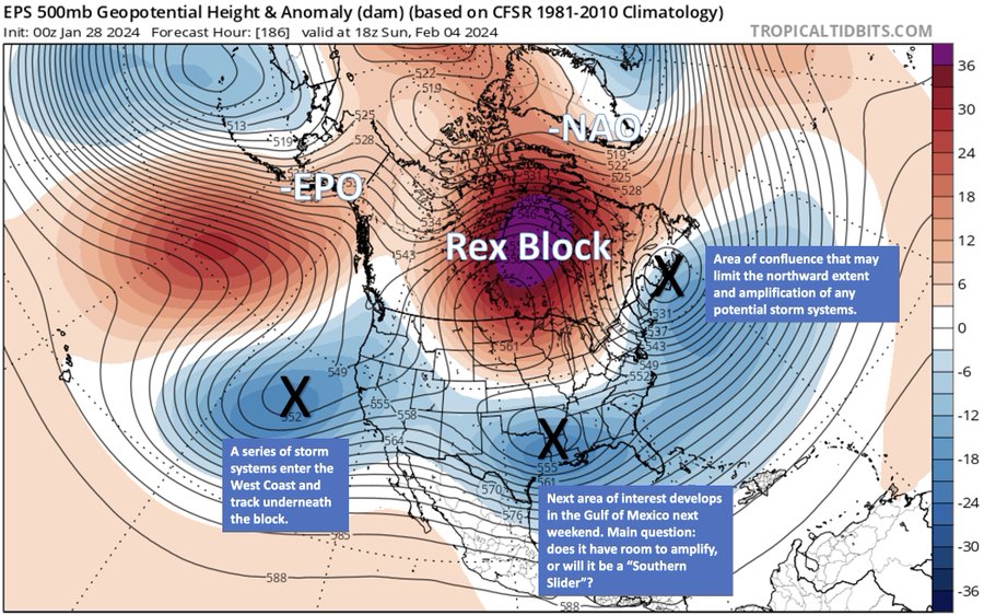
Andrew Markowitz: “This looks like the next potential window for winter weather on the East Coast. Somewhat untraditional pattern with a Rex Block over the Hudson Bay and the jet stream undercutting it to the south. Confluence over New England is a limiting factor, this screams Mid-Atlantic to SE.”
-
2
-
-
-
1 minute ago, WinstonSalemArlington said:
I know how this forum breaks down geography. But DT didn’t post this on this forum. Although it’s hotly debated, many consider NC part of the Mid-Atlantic. It’s even been debated here for years, but that’s not an invitation to revisit that debate. I posted that because of the substantive analysis by DT.
-
14 minutes ago, GaWx said:
But our SE subforum of AmericanWx has not only NC but also VA. So, even VA is included in many other cases as SE, not mid Atlantic. Some do count VA as being in the southern Mid Atlantic. If DT’s considering NC as S Mid Atlantic, he’s off imo.
The link below has VA in pink, which it is calling S Mid Atlantic:
https://en.m.wikipedia.org/wiki/Mid-Atlantic_(United_States)
I know how this forum breaks down geography. But DT didn’t post this on this forum. Although it’s hotly debated, many consider NC part of the Mid-Atlantic. It’s even been debated here for years, but that’s not an invitation to revisit that debate.
-
10 minutes ago, GaWx said:
Regarding the bolded, that would just make the already frustrated NC folks that much madder as that’s exactly what happened in the middle of this month. The sanitarium thread would be overwhelmed!
Why? DT and many other people include North Carolina into the definition of “southern Mid-Atlantic.”
-
2
-
-
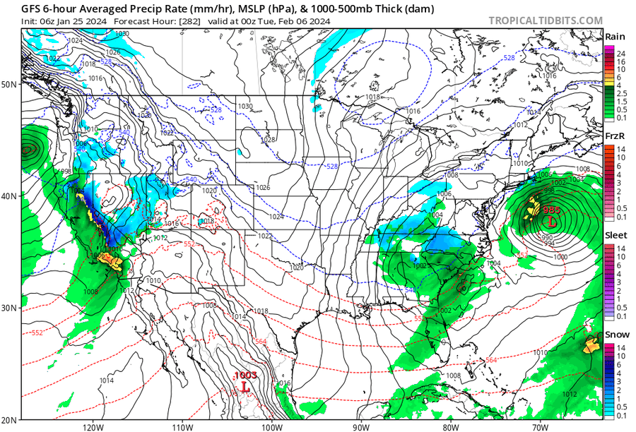
DT ALERT*:
⚠️**ALERT ** MAJOR CHANGES AT 500mb ACROSS NORTH AMERICA WILL END MILD PATTERN MUCH SOONER THAN INTIALLY THOUGHT⚠️
...as I said in the Tuesday edition of THIS WEEK IN WEEK ... this is called UNDERCUTTING
... rare PAMELA ANDERSON Pattern change ...
NEXT WEEK things are looking VERY different than what they appeared only 3-4 days ago. The 12z Models are showing some important changes.
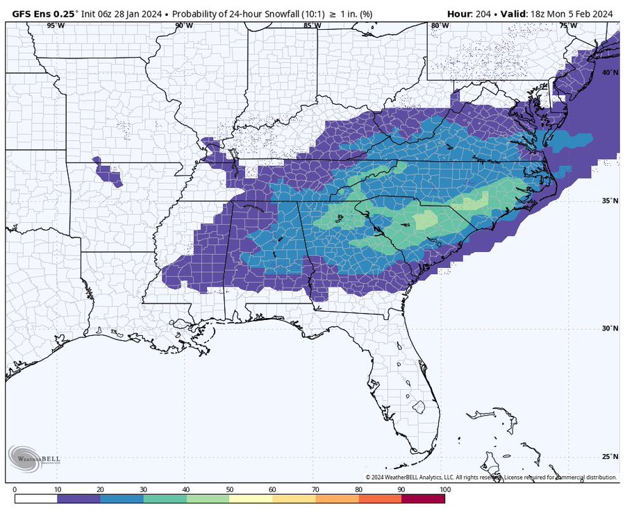
…TENN VALLEY southern Mid Atlantic snowstorm FEB 4-5?
https://x.com/wxrisksnowstorm/status/1750697773140255145?s=46&t=5ny5bPgiX5Vy3bQMvYTY5g
-
1
-
1
-
 1
1
-
-
February 10
-
12 days
-
1
-
1
-
-
Eric Webb:
I’m still not buying the idea of a “torch” in early Feb over much of the Eastern US.
Although we are getting a jet extension here, the southward shift of the Pacific Jet favors undercutting of the Canadian Ridge, keeping temps more seasonable east and south of the Great Lakes….
I still can’t quite figure out where the “true" beginning of spring lies in the longer-term over the Eastern US
Even out to near the middle of March, we still might be stuck in this -NAO/east-southeastern US trough-type look.
Imho, once we get past next week's Pacific Jet extension, we're in it for the long haul.”
-
5
-
1
-
-
January so far
-
1
-
1
-
-
Eric Webb: “
Over the next several weeks, we're repeating the same pattern progression we had in late Dec thru mid-Jan, except the cold(er) pattern on the backend of next week's Pacific Jet extension likely lasts longer (per usual for El Nino)
Aside from Nino climo, +IOD collapse favors a slower/stronger bout of Indian Ocean forcing late in Feb into Mar, helping to keep the gravy train going.
Remember that unlike Dec-Jan, Indian Ocean convection in Feb-Mar actually signals cold in the eastern US.”
-
3
-
1
-
-
Low of 19 today in Wilmington, NC. First time in the teens there in two years - Jan 2022.
-
1
-
-
11 at GSO
-
1
-
-
Nikhil Trivedi: “In summary, I’d expect the Eastern US to be mild through Jan 29 with a brief storm window Jan 29-31. We’re mild again to start Feb, with snow chances returning as we near mid Feb. The magnitude of the storm threats rely on what the NAO ends up doing.”
-
-
Western Ridge
-
1
-
2
-
-
-
Could this be the most depressed this Forum has ever been?
-
1 hour ago, GaWx said:
At Raleigh, these four moderate or stronger El Niño winters had no measurable SN Dec and Jan but soon afterward the pattern abruptly changed between Feb 6 and Feb 14:
1913-14:
- After an even shorter and less intense cold snap in mid Jan than the current one, the 3.5 week long period Jan 15-Feb 7 averaged 6 AN, which included 5 highs between 66 and 73 Jan 28-Feb 4. Then suddenly they plunged to average 10 BN Feb 8-Mar 23 with freezes on 26 of 44 days and 4 significant winter storms, which included 17.2” of SN.
1918-9:- 5 AN Jan 14-Feb 8 including 6 highs of 65-70 Jan 19-31
- 3.3” SN fell Feb 9
1923-4:- After 3 days of highs of 66-68 Feb 3-5 and AN Jan 29-Feb 5th, Feb 6th-29th averaged 7 BN along with 2.4” of SN. Another 2.1” fell in March.
1951-2:
- 5 AN Dec 29-Feb 13 including 6 highs in 70s
- 5 BN Feb 14-Mar 18 with 4.7” SN
Phenomenal post!
-
2
-
1
-


Winter 2023-4 Post-Mortem Thread
in Southeastern States
Posted
National Disaster