

Stovepipe
-
Posts
4,255 -
Joined
-
Last visited
Content Type
Profiles
Blogs
Forums
American Weather
Media Demo
Store
Gallery
Posts posted by Stovepipe
-
-
9 minutes ago, PowellVolz said:
I love a March surprises but it’s gonna be 70+ for 3 days this week, so we don’t need any surprises now.
.I've seen enough. I hereby declare kayaking season.

-
 4
4
-
-
2 minutes ago, John1122 said:
Today I observed rain, thunder and 9 cars on I-75 with flats from potholes.
I had to head up to Jacksboro today and man, I nearly broke an axel. I've never seen the interstate in such bad shape. I was also fortunate enough to get stuck at the Caryville on-ramp while they shut I-75 down to patch some holes. Also, it's amazing how much fog builds over there around Cove Lake. Campbell county really is another world lol.
-
2
-
 1
1
-
-
Got another huge bonfire going. I don't want this to end. May have to move to Canada.
-
9
-
-
You know it's been a helluva week of winter weather when I can't even be bothered to keep track of amounts anymore.

-
5
-
4
-
-
Really happy with the snow today. Been coming down at a pretty good rate for central valley NW flow.
-
4
-
-
I'm preparing for a power outage. Got candles, battery packs, and DC lighting ready to go. Propane stoves and pellet fire pit if needed.
-
2
-
-
Just walked to the road to take garbage out and yep, slicker than snot. Packed snow from tire tracks is hard to walk on. My car has a layer of glaze on it. Currently 29.5, I briefly topped out at 32 this afternoon. It'll be interesting to see if it drops any more. Glad I'm not having to drive in it, whew.
-
2
-
-
Well, with zero radar returns overhead we're still spitting out steady fine ice pellets at 21 degrees. This is certainly one for the record books.
-
4
-
-
Ripping sleet now. Unbelievable.
-
2
-
-
I've never seen anything like this in my life. Somehow it's still managing to snow on this glacier at 12:30am.
-
5
-
-
Biggest flakes of the event hitting here now. Got dimes, nickels, and even a quarter or two mixing in with those heavy returns. My gut tells me this is the last blast but who knows. Again, very very very grateful.
-
6
-
-
Slowed down a bit here, looks like a bit more is gonna roll through on radar. Damn near 24 hours of snowfall, can't complain at all. Got a porch fire going in the solo stove. Just gonna soak it all in.
-
5
-
-
Just now, 1234snow said:
6”
Yeah, that's gonna leave a mark. Congrats!
-
1
-
-
It just keeps pounding.


-
8
-
 2
2
-
-
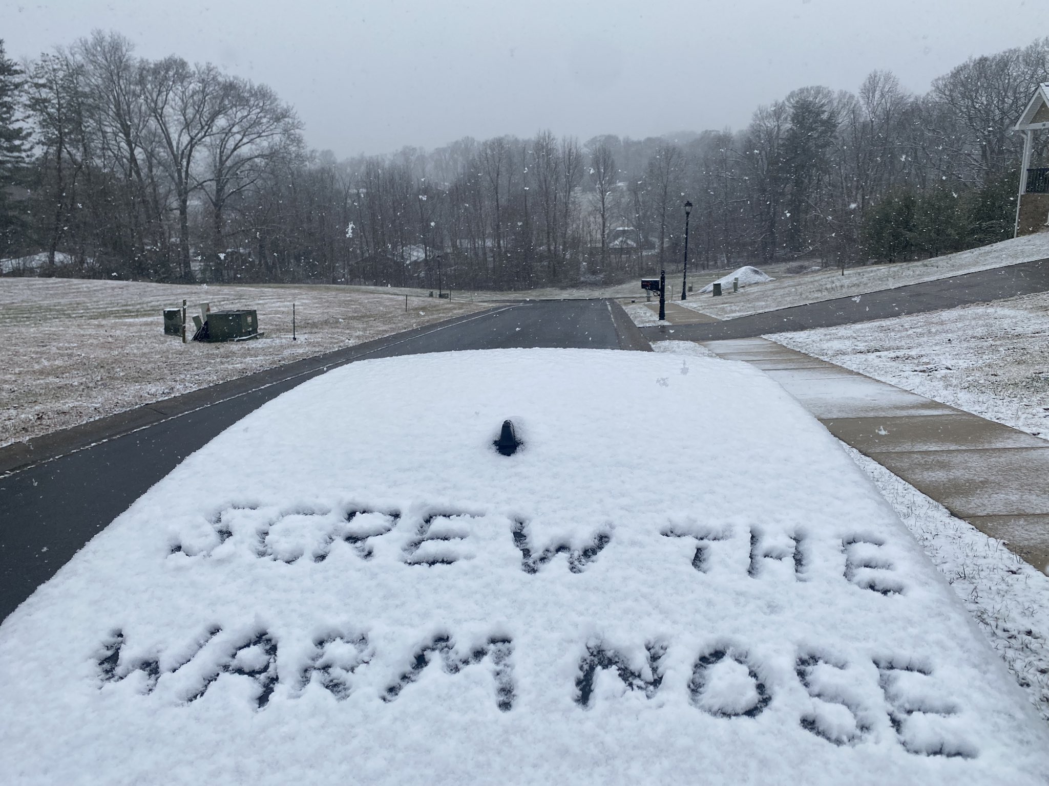
5 minutes ago, tnweathernut said:
Not my picture but summarizes my feelings well regarding the entire day today where rain has been occurring or mixing in.
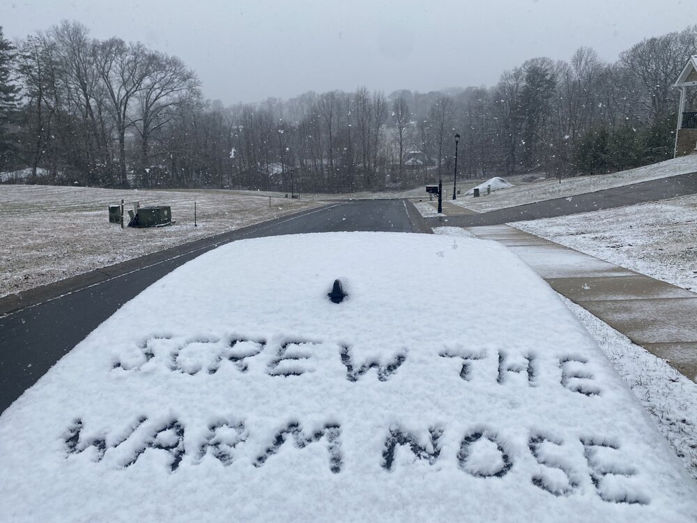
I'm really sorry about the warm nose. But this pic relates to me as I've been measuring my accums by peeing my name in the snow and timing how long it takes to fill in. Yes I'm a weirdo. And yes it's snowing very hard here.
-
5
-
-
Sand blasting pixie dust here at the moment but radar says that's about to change. Temp still dropping, down to 25.5.
-
4
-
-
The temp is dropping here, currently 26, wind has picked up, still at about the heaviest snow of the day. I measured about 7 inches in spots.
-
3
-
-
4 minutes ago, Carvers Gap said:
For several days, the NAM busted badly in the eastern valley as it didn't have any snow east of the Plateau. Globals did much better over here. The final run of the GFS before the event is probably going to verify for the most part with the exception of the foothills which mostmodels basically failed w/ until the last minute.. The Canadian sniffed out the problems in the eastern foothills first. Once the NAM came on board yesterday, it also had it. The HRRR also had it to some extent when it came into range. It is also worth pointing out that the NAM doing well in middle and west TN while not doing well here is easily explainable. It was closer in time to the event and those areas got cold quickly(better ratios). On this end, we were still several hours behind from a modeling standpoint...and it overdid accums on the Plateau and Cumberlands which was feedback. I do think the NC lee side low caused it problems. Once it lost that feedback(and we got closer in time), it did much better. It didn't dial-in here until about 12-16 hours to go. The other problem is that as the system backed and slowed, the NAM tended to feedback. The ICON is probably gonna be the big winner in all of this statewide, and that is probably a shock to most - me for sure. The 3k NAM was particularly good. The 12k NAM was terrible. The RAP and HRRR have been really good as well. I don't like the RAP, but it has done decently this go around.
As MRX noted, no model had the warm air pushing to I-81 in NE TN.....personally, I think the front stalled at dawn at the Plateau and then daytime temps caused issues. The front stalling on the Plateau is not unusual. As Tellico noted the other day, Knoxville has a nice pathway for cold air from the Plateau. Chattanooga and TRI do not. The big red flag was when temps in NE TN yesterday beat forecast highs by 8 degrees. That produced a lot of warm air to scour as we got cloudy at dark, and warm air couldn't scour. Then it go banked against the Apps this AM.
The NAM itself is I think a false positive. It got some things right, but for the wrong reason IMO. It got incorrectly amped and missed the track, but its snow totals worked out. Why? The cold air moved aggressively into middle and west TN and allowed rates to be crazy good. I have roughy 4" of snow right now. My ratio might be 8:1. If it was colder, I would likely have double that. So, whichever model moved the cold in most aggressively is correct...and I don't which one that is....probably the RGEM? The other thing is that the over-amping of the NAM gave it some semblance of expanding the precip shield. Its precip shield was juiced due to feedback and had a bad track in the East - plenty of snow fell east of the Apps which it didn't have. In reality, that precip shield was going to fill in as the rush of cold air squeezed every drop of moisture out of the air - it was impressive. The entry point of heavy precip was decently modeled and didn't change much.
Still looking through some of the reports from middle and west TN which are incredibly helpful. I think the main bust(and let's be honest, nobody cares if a model busts and they get more snow than shown), is the foothills...and that may take some time to figure out.
You are an absolute treasure in this forum, thank you for that post and all that you do. This is incredibly useful information to reflect on going forward.
-
5
-
-
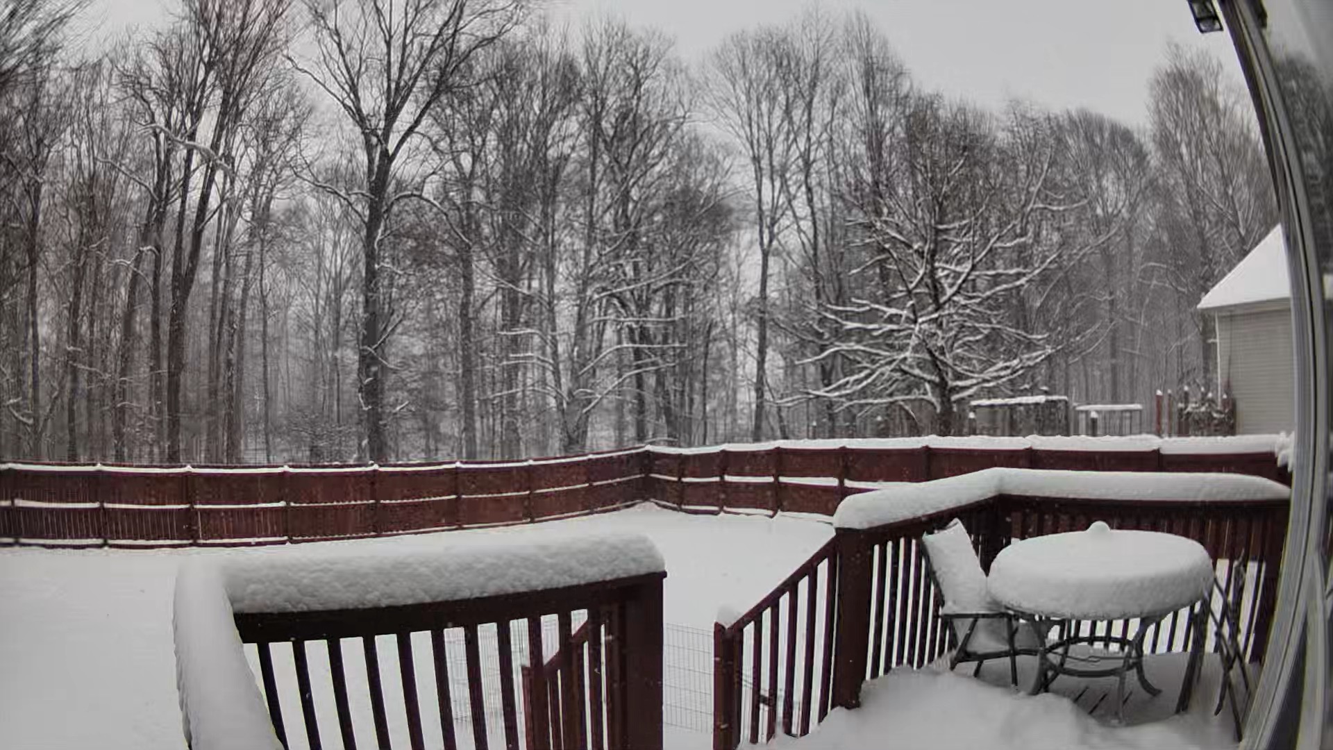
I'm gonna go ahead and say this is the best snow experience I've had since moving to east TN in 1994. Not necessarily the biggest flakes or heaviest convective bands but damn good. I was here for Jan/Feb 96. March 2022 was some of the hardest I've seen fall and possibly the most accumulation at my area. But this long duration event is a thing of beauty. I'm over the 6 inch mark currently and the scene outside is picture perfect dime ripping heavy snow with fatty radar returns on the way. Best east TN storm for me. Very very grateful.
-
11
-
 3
3
-
-
Yeah, heaviest snow of the day here too, ripping dimes out there!

-
6
-
-
1 minute ago, Olhausen said:
I’m in White House. Gonna be over 6 inches when all said and done.

There we go, I'm glad you got pasted, thanks for the pic!
-
1
-
-
2 minutes ago, AMZ8990 said:
Did you see the freaking video on twitter of a dude being pulled on a car hood behind a truck on I-240 last night in Memphis?
I did not, but am not surprised in the least. I hope John posts more shenanigans from the scanner. People lose their got dang minds when it snows around here.
-
2
-
-
3 minutes ago, Silas Lang said:
Snow really started picking up in intensity now.
Yeah the wind and flake size increased with this band, friggin awesome.
-
3
-
-
7 minutes ago, Greyhound said:
Got mine prepped and ready in case I NEED to get out. Still debating if I want to get out and play though……
.It's the dumbasses that make it not fun out there, otherwise I'd love to be cruising around in the Subaru.
-
2
-
February 2024 mid/ long range
in Tennessee Valley
Posted
Best week of winter I've had since moving to east TN in 1994. No complaints here at all. Now to find some fish that are biting.